ATL: FRANCINE - Remnants - Discussion

Moderator: S2k Moderators

Message
Author
User avatar
NDG
S2K Supporter
S2K Supporter
Posts: 15446
Joined: Sun Jul 09, 2006 10:14 pm
Location: Orlando, FL

Re: ATL: FRANCINE - Tropical Storm - Discussion

#421 Postby NDG » Mon Sep 09, 2024 4:22 pm

Hurrilurker wrote:Organization looks great and coming together rapidly but there's still a huge slot of dry air in there it needs to mix out.


I'm sure the time of the day may have a lot to do with it.
0 likes   

User avatar
Ubuntwo
Category 5
Category 5
Posts: 1406
Age: 31
Joined: Thu Oct 05, 2017 10:41 pm

Re: ATL: FRANCINE - Tropical Storm - Discussion

#422 Postby Ubuntwo » Mon Sep 09, 2024 4:23 pm

cheezyWXguy wrote:Dry air entrainment during this phase is common, and microwave/radar show that everything under the hood is organizing. Pressure is probably the same or a little lower than the recon pass earlier, guess we’ll see when it gets there. Unless new convection doesn’t form in the eyewall overnight, I don’t think anything we are seeing suggests this to be a weakening storm.

I agree, though it wouldn’t surprise me to see winds the same or even slightly lower in the very short term. This is usually a period of axisymmetrization, where the storm develops a more balanced wind structure - usually a prerequisite to RI.
3 likes   
Kendall -> SLO -> PBC

Memorable Storms: Katrina (for its Florida landfall...) Wilma Matthew Irma

User avatar
WaveBreaking
Category 2
Category 2
Posts: 578
Joined: Sun Jun 30, 2024 11:33 am
Location: US

Re: ATL: FRANCINE - Tropical Storm - Discussion

#423 Postby WaveBreaking » Mon Sep 09, 2024 4:36 pm

Ubuntwo wrote:
cheezyWXguy wrote:Dry air entrainment during this phase is common, and microwave/radar show that everything under the hood is organizing. Pressure is probably the same or a little lower than the recon pass earlier, guess we’ll see when it gets there. Unless new convection doesn’t form in the eyewall overnight, I don’t think anything we are seeing suggests this to be a weakening storm.

I agree, though it wouldn’t surprise me to see winds the same or even slightly lower in the very short term. This is usually a period of axisymmetrization, where the storm develops a more balanced wind structure - usually a prerequisite to RI.


Yeah, reminds me of when Ian had that skeletal look to it before starting its RI phase before Cuba. Not saying that it will pull off what Ian did tho.
2 likes   
I am NOT a professional meteorologist, so take all of my posts with a grain of salt. My opinions are mine and mine alone.

User avatar
Teban54
Category 5
Category 5
Posts: 3206
Joined: Sat May 19, 2018 1:19 pm

Re: ATL: FRANCINE - Tropical Storm - Discussion

#424 Postby Teban54 » Mon Sep 09, 2024 4:56 pm

Even though the SE quad is obviously less convectively active at the moment, it gives some gorgeous visible imagery.

Image

Image
4 likes   

xironman
S2K Supporter
S2K Supporter
Posts: 2522
Joined: Sun Jun 10, 2007 4:53 pm
Location: NoVA

Re: ATL: FRANCINE - Tropical Storm - Discussion

#425 Postby xironman » Mon Sep 09, 2024 5:00 pm

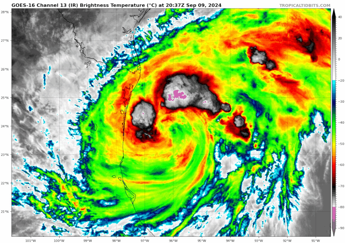
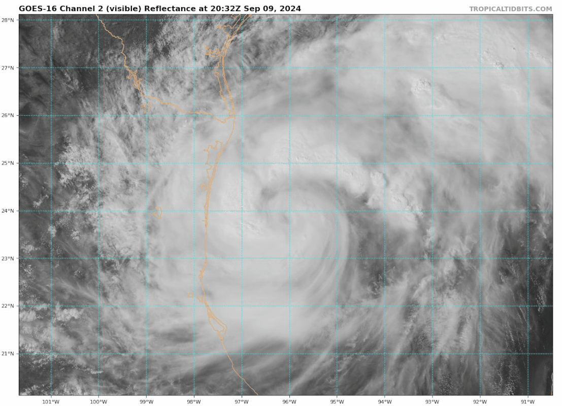
Teban54 wrote:Even though the SE quad is obviously less convectively active at the moment, it gives some gorgeous visible imagery.


Those mesos swinging around the proto eyewall should take car of that
0 likes   

Visioen
S2K Supporter
S2K Supporter
Posts: 286
Joined: Sat Sep 02, 2017 2:08 pm
Location: Belgium, Europe

Re: ATL: FRANCINE - Tropical Storm - Discussion

#426 Postby Visioen » Mon Sep 09, 2024 5:01 pm

Is it doing an EWRC yet

:spam:
1 likes   

User avatar
Teban54
Category 5
Category 5
Posts: 3206
Joined: Sat May 19, 2018 1:19 pm

Re: ATL: FRANCINE - Tropical Storm - Discussion

#427 Postby Teban54 » Mon Sep 09, 2024 5:01 pm

Ubuntwo wrote:
cheezyWXguy wrote:Dry air entrainment during this phase is common, and microwave/radar show that everything under the hood is organizing. Pressure is probably the same or a little lower than the recon pass earlier, guess we’ll see when it gets there. Unless new convection doesn’t form in the eyewall overnight, I don’t think anything we are seeing suggests this to be a weakening storm.

I agree, though it wouldn’t surprise me to see winds the same or even slightly lower in the very short term. This is usually a period of axisymmetrization, where the storm develops a more balanced wind structure - usually a prerequisite to RI.

This was also well-anticipated by the hurricane models. HAFS-A and B, the only two models that correctly showed the 995 mb pressure around 17z, had slow or negligible deepening in the following 12-18 hours before starting RI.
2 likes   

sphelps8681
Category 2
Category 2
Posts: 785
Joined: Thu Aug 16, 2007 5:37 pm
Location: Somewhere over the rainbow

Re: ATL: FRANCINE - Tropical Storm - Discussion

#428 Postby sphelps8681 » Mon Sep 09, 2024 5:01 pm

Is it possible for another eyewall reformation? Or is it done. Thanks.
0 likes   

User avatar
NDG
S2K Supporter
S2K Supporter
Posts: 15446
Joined: Sun Jul 09, 2006 10:14 pm
Location: Orlando, FL

Re: ATL: FRANCINE - Tropical Storm - Discussion

#429 Postby NDG » Mon Sep 09, 2024 5:02 pm

Teban54 wrote:
Ubuntwo wrote:
cheezyWXguy wrote:Dry air entrainment during this phase is common, and microwave/radar show that everything under the hood is organizing. Pressure is probably the same or a little lower than the recon pass earlier, guess we’ll see when it gets there. Unless new convection doesn’t form in the eyewall overnight, I don’t think anything we are seeing suggests this to be a weakening storm.

I agree, though it wouldn’t surprise me to see winds the same or even slightly lower in the very short term. This is usually a period of axisymmetrization, where the storm develops a more balanced wind structure - usually a prerequisite to RI.

This was also well-anticipated by the hurricane models. HAFS-A and B, the only two models that correctly showed the 995 mb pressure around 17z, had slow or negligible deepening in the following 12-18 hours before starting RI.


Very impressed with HAFS so far.
0 likes   

Visioen
S2K Supporter
S2K Supporter
Posts: 286
Joined: Sat Sep 02, 2017 2:08 pm
Location: Belgium, Europe

Re: ATL: FRANCINE - Tropical Storm - Discussion

#430 Postby Visioen » Mon Sep 09, 2024 5:04 pm

sphelps8681 wrote:Is it possible for another eyewall reformation? Or is it done. Thanks.

I think you mean center reformation. It's done.
1 likes   

User avatar
LadyBug72
Tropical Storm
Tropical Storm
Posts: 118
Joined: Mon Jun 01, 2020 3:39 pm
Location: about 20 miles from Galveston, Tx

Re: ATL: FRANCINE - Tropical Storm - Discussion

#431 Postby LadyBug72 » Mon Sep 09, 2024 5:06 pm

sphelps8681 wrote:Is it possible for another eyewall reformation? Or is it done. Thanks.


Meteorologist Eric Graves said another reformation would be extremely rare given how deep the new center is.
1 likes   
Formerly known as the user: Nikki

Alicia 83, Allison 01, Rita 05, Ike 08, Harvey 17, Nicholas 21, Coastal Texas Derecho 24, Beryl 24

User avatar
WiscoWx02
Category 1
Category 1
Posts: 391
Joined: Sat Jul 31, 2021 8:09 pm

Re: ATL: FRANCINE - Tropical Storm - Discussion

#432 Postby WiscoWx02 » Mon Sep 09, 2024 5:13 pm

The dry air entrainment struggle has begun and will likely continue to plague the system until landfall. Category 1 is the likely ceiling thanks to entrainment. Models have been seeing this more and more today, with the dry air struggle being clearly show on the Euro’s 700-300 hPa Relative Humidity scheme…GFS shows it as well.
0 likes   

User avatar
Hypercane_Kyle
Category 5
Category 5
Posts: 3352
Joined: Sat Mar 07, 2015 7:58 pm
Location: Cape Canaveral, FL

Re: ATL: FRANCINE - Tropical Storm - Discussion

#433 Postby Hypercane_Kyle » Mon Sep 09, 2024 5:19 pm

WiscoWx02 wrote:The dry air entrainment struggle has begun and will likely continue to plague the system until landfall. Category 1 is the likely ceiling thanks to entrainment. Models have been seeing this more and more today, with the dry air struggle being clearly show on the Euro’s 700-300 hPa Relative Humidity scheme…GFS shows it as well.


Not sure we're seeing dry air issues... this looks like natural diurnal effects.
3 likes   
My posts are my own personal opinion, defer to the National Hurricane Center (NHC) and other NOAA products for decision making during hurricane season.

xironman
S2K Supporter
S2K Supporter
Posts: 2522
Joined: Sun Jun 10, 2007 4:53 pm
Location: NoVA

Re: ATL: FRANCINE - Tropical Storm - Discussion

#434 Postby xironman » Mon Sep 09, 2024 5:19 pm

WiscoWx02 wrote:The dry air entrainment struggle has begun and will likely continue to plague the system until landfall. Category 1 is the likely ceiling thanks to entrainment. Models have been seeing this more and more today, with the dry air struggle being clearly show on the Euro’s 700-300 hPa Relative Humidity scheme…GFS shows it as well.


I don't see significant dry air until Wed
2 likes   

User avatar
ConvergenceZone
Category 5
Category 5
Posts: 5194
Joined: Fri Jul 29, 2005 1:40 am
Location: Northern California

Re: ATL: FRANCINE - Tropical Storm - Discussion

#435 Postby ConvergenceZone » Mon Sep 09, 2024 5:20 pm

WiscoWx02 wrote:The dry air entrainment struggle has begun and will likely continue to plague the system until landfall. Category 1 is the likely ceiling thanks to entrainment. Models have been seeing this more and more today, with the dry air struggle being clearly show on the Euro’s 700-300 hPa Relative Humidity scheme…GFS shows it as well.


If what you are saying is true, then why did the NHC just upgrade the landfall to a strong Cat 2? almost Cat 3?
9 likes   

User avatar
NDG
S2K Supporter
S2K Supporter
Posts: 15446
Joined: Sun Jul 09, 2006 10:14 pm
Location: Orlando, FL

Re: ATL: FRANCINE - Tropical Storm - Discussion

#436 Postby NDG » Mon Sep 09, 2024 5:23 pm

Plenty of good data is going to be going into tonight's 0z models' runs.

Image
2 likes   

User avatar
Blinhart
Category 5
Category 5
Posts: 2081
Age: 48
Joined: Thu Sep 08, 2011 3:13 pm
Location: Crowley, La.

Re: ATL: FRANCINE - Tropical Storm - Discussion

#437 Postby Blinhart » Mon Sep 09, 2024 5:28 pm

WiscoWx02 wrote:The dry air entrainment struggle has begun and will likely continue to plague the system until landfall. Category 1 is the likely ceiling thanks to entrainment. Models have been seeing this more and more today, with the dry air struggle being clearly show on the Euro’s 700-300 hPa Relative Humidity scheme…GFS shows it as well.


Where are you getting all this??? all models are saying Cat 2 is most likely and Cat 3 isn't still out of realm of possibility.
7 likes   
Personal Forecast Disclaimer:
The posts in this forum are NOT official forecast and should not be used as such. They are just the opinion of the poster and may or may not be backed by sound meteorological data. They are NOT endorsed by any professional institution or storm2k.org. For official information, please refer to the NHC and NWS products.

User avatar
Category5Kaiju
Category 5
Category 5
Posts: 4097
Joined: Thu Dec 24, 2020 12:45 pm
Location: Seattle

Re: ATL: FRANCINE - Tropical Storm - Discussion

#438 Postby Category5Kaiju » Mon Sep 09, 2024 5:39 pm

WiscoWx02 wrote:The dry air entrainment struggle has begun and will likely continue to plague the system until landfall. Category 1 is the likely ceiling thanks to entrainment. Models have been seeing this more and more today, with the dry air struggle being clearly show on the Euro’s 700-300 hPa Relative Humidity scheme…GFS shows it as well.


The NHC just updated the possible landfall intensity, which is now at Category 2 strength.

Is there a specific source you're getting this info? Don't get me wrong, I'd be extremely happy if this system underperforms and hits land as a minimal strength system, but unfortunately the trends have not been going in that direction.
Last edited by Category5Kaiju on Mon Sep 09, 2024 5:53 pm, edited 1 time in total.
1 likes   
Unless explicitly stated, all info in my posts is based on my own opinions and observations. Tropical storms and hurricanes can be extremely dangerous. Do not think you can beat Mother Nature. Refer to an accredited weather research agency or meteorologist if you need to make serious decisions regarding an approaching storm.

BobHarlem
Category 5
Category 5
Posts: 2108
Joined: Thu Oct 20, 2005 6:11 pm

Re: ATL: FRANCINE - Tropical Storm - Discussion

#439 Postby BobHarlem » Mon Sep 09, 2024 5:41 pm

WiscoWx02 wrote:The dry air entrainment struggle has begun and will likely continue to plague the system until landfall. Category 1 is the likely ceiling thanks to entrainment. Models have been seeing this more and more today, with the dry air struggle being clearly show on the Euro’s 700-300 hPa Relative Humidity scheme…GFS shows it as well.


I'm not seeing any dry air on the water vapor getting in, don't confuse it with structural issues of it winding up (and daytime warming). It could get the dry air later but not until around landfall time, by then the momentum will already have been established and surge, etc.

Image

Outflow is good, any dry air getting in from the outside is getting mixed out at all levels, which the WV shows plainly here:

Image
4 likes   

TomballEd
Category 2
Category 2
Posts: 699
Age: 61
Joined: Wed Aug 16, 2023 4:52 pm
Location: Spring/Klein area, not Tomball

Re: ATL: FRANCINE - Tropical Storm - Discussion

#440 Postby TomballEd » Mon Sep 09, 2024 5:49 pm

A storm this time of year would often head W or NW, but the jet is very far S. This usually happens closer to the Equinox, I assume it is temporary. Ian strengthening despite shear and dry air shows how much baroclinic processes can maintain a storm or at least reduce its decay in otherwise less favorable conditions. I'm not sure looking at long range BRO radar dry air is already affecting the core. GFS doesn't get the dry air to the core until just before landfall.
1 likes   


Return to “2024”

Who is online

Users browsing this forum: No registered users and 2 guests