

Seeing radial fingers on IR now.
https://www.tropicaltidbits.com/sat/sat ... product=ir
NATL: MELISSA - Aftermath - Discussion
Moderator: S2k Moderators
Re: NATL: MELISSA - Tropical Storm - Discussion
Hopefully there is an EWRC underway while on approach to Jamaica
0 likes
-
ScottNAtlanta

- Category 5

- Posts: 2535
- Joined: Sat May 25, 2013 3:11 pm
- Location: Atlanta, GA
Re: NATL: MELISSA - Tropical Storm - Discussion
cheezyWXguy wrote:GCANE wrote:Visible Satellite showing rapid convergence at the mid-levels.
This will work down to the surface before sunset.
https://www.tropicaltidbits.com/sat/sat ... roduct=vis
I wouldn’t be surprised if this drill down process were attempting to take place right now, that mlc looks vigorous, especially with upper level outflow beginning to increase radially from the center of that main burst. The current llc centered on the nw side of this burst seems to be losing influence. I wonder how long it will be before recon starts seeing evidence of this process.
Recon really is hitting that area. They've looped around and are going back to it
1 likes
The posts in this forum are NOT official forecast and should not be used as such. They are just the opinion of the poster and may or may not be backed by sound meteorological data. They are NOT endorsed by any professional institution or storm2k.org. For official information, please refer to the NHC and NWS products.

Re: NATL: MELISSA - Tropical Storm - Discussion
aspen wrote:11am cone now shows a 130 kt landfall in Jamaica.
If this verifies this would be the strongest landfalling hurricane on record in Jamaica.
2 likes

Re: NATL: MELISSA - Tropical Storm - Discussion
ljmac75 wrote:aspen wrote:11am cone now shows a 130 kt landfall in Jamaica.
If this verifies this would be the strongest landfalling hurricane on record in Jamaica.
The advisory also had an ominous note about why:
Every single Google DeepMind member shows the
system become a Category 4 hurricane or higher, and the uncertainty
is more related on the timing of when RI occurs. [...] The latest NHC intensity forecast is
on the higher end of the model solutions, but more or less in line
with the latest GDMI guidance.
system become a Category 4 hurricane or higher, and the uncertainty
is more related on the timing of when RI occurs. [...] The latest NHC intensity forecast is
on the higher end of the model solutions, but more or less in line
with the latest GDMI guidance.
7 likes
TC naming lists: retirements and intensity
Most aggressive Advisory #1's in North Atlantic (cr. kevin for starting the list)
Most aggressive Advisory #1's in North Atlantic (cr. kevin for starting the list)
-
cycloneye

- Admin

- Posts: 149686
- Age: 69
- Joined: Thu Oct 10, 2002 10:54 am
- Location: San Juan, Puerto Rico
Re: NATL: MELISSA - Tropical Storm - Discussion
Hey folks. The winds are going up now as the AF plane continues the mission.
Peak Flight-Level Winds: 59kt at 15:58z
Peak SFMR: 58kt at 15:57z
Peak SFMR: 58kt at 15:57z
6 likes
Visit the Caribbean-Central America Weather Thread where you can find at first post web cams,radars
and observations from Caribbean basin members Click Here
and observations from Caribbean basin members Click Here


Re: NATL: MELISSA - Tropical Storm - Discussion
Recon is observing 50~60 kt flight-level winds, and Melissa's satellite presentation is still improving. If that trend persists, I think it's quite possible that the NHC will go with 45 kts on the 18z advisory, which would be in line with their forecasts from last night.
0 likes
NATL: MELISSA - Tropical Storm - Discussion
Looks like it survived the Caribbean Graveyard (to say the least)...
1 likes
-
Sciencerocks
- Category 5
- Posts: 10189
- Age: 40
- Joined: Thu Jul 06, 2017 1:51 am


Re: NATL: MELISSA - Tropical Storm - Discussion
sasha_B wrote:Recon is observing 50~60 kt flight-level winds, and Melissa's satellite presentation is still improving. If that trend persists, I think it's quite possible that the NHC will go with 45 kts on the 18z advisory, which would be in line with their forecasts from last night.
Special advisory:
12:30 PM EDT Fri Oct 24
Location: 15.6°N 74.5°W
Moving: ESE at 2 mph
Min pressure: 999 mb
Max sustained: 60 mph
2 likes
-
cheezyWXguy

- Category 5
- Posts: 6282
- Joined: Mon Feb 13, 2006 12:29 am
- Location: Dallas, TX
Re: NATL: MELISSA - Tropical Storm - Discussion
Recon suggests we are seeing more of a “meeting in the middle” scenario where the mlc and llc are converging, rather than a scenario where the mlc drills down to the surface and the old llc is discarded. Intensification looks to be occurring faster now.
2 likes
Re: NATL: MELISSA - Tropical Storm - Discussion
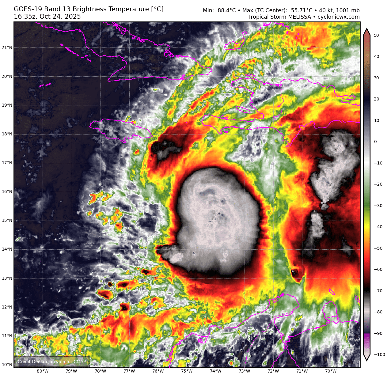
Tropical Storm Melissa Tropical Cyclone Update
NWS National Hurricane Center Miami FL AL132025
1230 PM EDT Fri Oct 24 2025
...AIRCRAFT DATA INDICATES THAT MELISSA IS STRENGTHENING...
Air Force Reserve reconnaissance aircraft data indicates that
Melissa is strengthening, and maximum sustained winds are now
estimated to be 60 mph (95 km/h) with higher gusts. The minimum
pressure from aircraft dropsonde data has dropped to 999 mb
(29.50 inches).
SUMMARY OF 1230 PM EDT...1630 UTC...INFORMATION
---------------------------------------------------
LOCATION...15.6N 74.5W
ABOUT 220 MI...355 KM SE OF KINGSTON JAMAICA
ABOUT 250 MI...405 KM SW OF PORT AU PRINCE HAITI
MAXIMUM SUSTAINED WINDS...60 MPH...95 KM/H
PRESENT MOVEMENT...ESE OR 105 DEGREES AT 2 MPH...4 KM/H
MINIMUM CENTRAL PRESSURE...999 MB...29.50 INCHES
$$
Forecaster Papin
0 likes
Re: NATL: MELISSA - Tropical Storm - Discussion
Does Melissa have the potential to affect Florida?
0 likes

-
Iceresistance

- Category 5
- Posts: 9605
- Age: 22
- Joined: Sat Oct 10, 2020 9:45 am
- Location: Tecumseh, OK/Norman, OK
Re: NATL: MELISSA - Tropical Storm - Discussion
4 likes
Bill 2015 & Beta 2020
Winter 2020-2021
All observations are in Tecumseh, OK unless otherwise noted.
Winter posts are focused mainly for Oklahoma & Texas.
Take any of my forecasts with a grain of salt, refer to the NWS, SPC, and NHC for official information
Never say Never with weather! Because ANYTHING is possible!
Winter 2020-2021
All observations are in Tecumseh, OK unless otherwise noted.
Winter posts are focused mainly for Oklahoma & Texas.
Take any of my forecasts with a grain of salt, refer to the NWS, SPC, and NHC for official information
Never say Never with weather! Because ANYTHING is possible!
Who is online
Users browsing this forum: No registered users and 75 guests