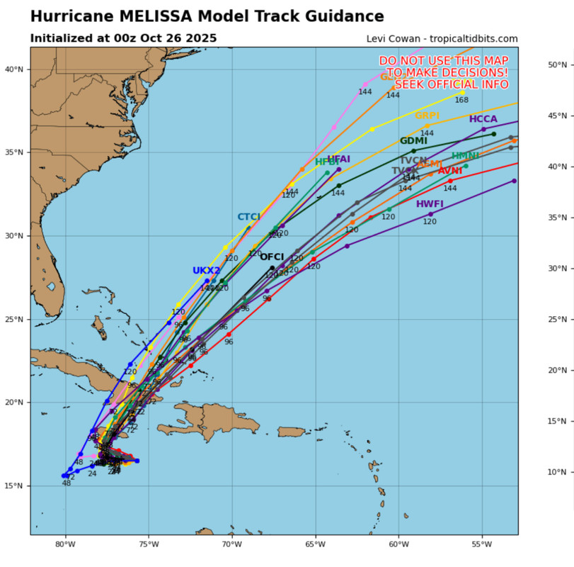
NATL: MELISSA - Models

Current storms and invests:

Moderators: hurricanetrack, S2k Moderators


The posts in this forum are NOT official forecasts and should not be used as such. They are just the opinion of the poster and may or may not be backed by sound meteorological data. They are NOT endorsed by any professional institution or STORM2K. For official information, please refer to products from the National Hurricane Center and National Weather Service.

Help Support Storm2K
Message
Author
User avatar
mitchell
Category 1
Category 1
Posts: 436
Joined: Wed Mar 19, 2003 8:22 am
Location: Delaware
Contact:

Re: NATL: MELISSA - Models

#421 Postby mitchell » Sat Oct 25, 2025 10:14 am

BobHarlem wrote:
Blown Away wrote:If Melissa’s core misses Jamaica to the east, which I think will happen, was the GFS closest to being correct all along being the persistent right outlier?


5 days ago, the GFS had it northeast of the DR right now. No way to say anything but the GFS handled it horribly. Euro was slightly north of where it was now. 6z GFS is still too far east.


Yes - I remember a couple days ago noticing that the GFS still had it ejecting NNE across Haiti/DR and nowhere near Jamaica while virtually every other model had it drifting slowly west towards Jamaica. GFS run from just 2 days ago (in which it would be landfalling in Haiti now):

Image
1 likes   

User avatar
cycloneye
Admin
Admin
Posts: 148227
Age: 69
Joined: Thu Oct 10, 2002 10:54 am
Location: San Juan, Puerto Rico

Re: NATL: MELISSA - Models

#422 Postby cycloneye » Sat Oct 25, 2025 10:51 am

What a big change from GFS. Now is south of Jamaica.

Image
0 likes   
Visit the Caribbean-Central America Weather Thread where you can find at first post web cams,radars
and observations from Caribbean basin members Click Here

User avatar
Blown Away
S2K Supporter
S2K Supporter
Posts: 10245
Joined: Wed May 26, 2004 6:17 am

Re: NATL: MELISSA - Models

#423 Postby Blown Away » Sat Oct 25, 2025 10:56 am

Image

12z ICON shifts to W end of Jamaica.
0 likes   
Hurricane Eye Experience: David 79, Irene 99, Frances 04, Jeanne 04, Wilma 05… Hurricane Brush Experience: Andrew 92, Erin 95, Floyd 99, Matthew 16, Irma 17, Ian 22, Nicole 22…

LarryWx
S2K Supporter
S2K Supporter
Posts: 6835
Joined: Sun Sep 07, 2003 2:04 pm
Location: GA

Re: NATL: MELISSA - Models

#424 Postby LarryWx » Sat Oct 25, 2025 12:58 pm

12Z Euro: goes back to an extent to the pre 0Z/6Z runs by being a bit further S of Jamaica thus helping it to get stronger (962) and thus it hits Jamaica at 971 instead of 986-8. It then goes back to a NE move over Jamaica and exits at 977 vs 992 of 0Z/6Z. As a result, the 20” line goes back further W to center of Jamaica.
0 likes   
Personal Forecast Disclaimer:
The posts in this forum are NOT official forecasts and should not be used as such. They are just the opinion of the poster and may or may not be backed by sound meteorological data. They are NOT endorsed by any professional institution or storm2k.org. For official information, please refer to the NHC and NWS products.

User avatar
Kazmit
Category 5
Category 5
Posts: 2242
Age: 22
Joined: Mon Jul 25, 2016 8:49 am
Location: Bermuda

Re: NATL: MELISSA - Models

#425 Postby Kazmit » Sat Oct 25, 2025 1:44 pm

Only took the GFS this long to show what the Euro has been showing for five days. :lol:
3 likes   
Igor 2010, Sandy 2012, Fay 2014, Gonzalo 2014, Joaquin 2015, Nicole 2016, Humberto 2019, Imelda 2025

I am only a tropical weather enthusiast. My predictions are not official and may or may not be backed by sound meteorological data. For official information, please refer to the NHC and NWS products.

TomballEd
Category 5
Category 5
Posts: 1065
Age: 61
Joined: Wed Aug 16, 2023 4:52 pm
Location: Spring/Klein area, not Tomball

Re: NATL: MELISSA - Models

#426 Postby TomballEd » Sat Oct 25, 2025 2:51 pm

LarryWx wrote:12Z Euro: goes back to an extent to the pre 0Z/6Z runs by being a bit further S of Jamaica thus helping it to get stronger (962) and thus it hits Jamaica at 971 instead of 986-8. It then goes back to a NE move over Jamaica and exits at 977 vs 992 of 0Z/6Z. As a result, the 20” line goes back further W to center of Jamaica.


I know you know this but models with 9 or 12 km resolution probably will be a bit too high with central pressure. (I'd probably split the difference between the HAFS B and the Euro) I do suspect the delay in RI means the possibility of a Cat 5 landfall is greatly reduced although a major seems a near certainty, although the big killer, the floods and mudslides won't be helped much.
1 likes   

tolakram
Admin
Admin
Posts: 20147
Age: 62
Joined: Sun Aug 27, 2006 8:23 pm
Location: Florence, KY (name is Mark)

Re: NATL: MELISSA - Models

#427 Postby tolakram » Sat Oct 25, 2025 3:06 pm

The GFS only corrected once shear was gone. That shear induced bias with an overly vigorous MLC is really really bad, except for the 1 time it actually worked out. :lol:
5 likes   
M a r k
- - - - -
Join us in chat: Storm2K Chatroom Invite. Android and IOS apps also available.

The posts in this forum are NOT official forecasts and should not be used as such. Posts are NOT endorsed by any professional institution or STORM2K.org. For official information and forecasts, please refer to NHC and NWS products.

USTropics
Professional-Met
Professional-Met
Posts: 2725
Joined: Sun Aug 12, 2007 3:45 am
Location: Florida State University

Re: NATL: MELISSA - Models

#428 Postby USTropics » Sat Oct 25, 2025 8:11 pm

tolakram wrote:The GFS only corrected once shear was gone. That shear induced bias with an overly vigorous MLC is really really bad, except for the 1 time it actually worked out. :lol:


The only reason these graphs go to 400 and 700 km respectively, is because the GFS missed that badly. Like you said, the GFS known bias with convective parameterization over the displaced MLC to the north and deepening the system there (which tugged the LLC north under it) was exponentially worse because of the fine line in steering.

Image
6 likes   

User avatar
Blown Away
S2K Supporter
S2K Supporter
Posts: 10245
Joined: Wed May 26, 2004 6:17 am

Re: NATL: MELISSA - Models

#429 Postby Blown Away » Sat Oct 25, 2025 8:42 pm

Image

00z Early model cluster slight W shift from 18z.
0 likes   
Hurricane Eye Experience: David 79, Irene 99, Frances 04, Jeanne 04, Wilma 05… Hurricane Brush Experience: Andrew 92, Erin 95, Floyd 99, Matthew 16, Irma 17, Ian 22, Nicole 22…

User avatar
sponger
S2K Supporter
S2K Supporter
Posts: 1626
Joined: Thu Jul 22, 2004 11:26 am
Location: St Augustine

Re: NATL: MELISSA - Models

#430 Postby sponger » Sun Oct 26, 2025 3:53 am

Something has to be done about addressing the GFS deficiencies in hurricane modeling. Its performance the last five years seems abysmal.
3 likes   
The following post is NOT an official forecast and should not be used as such. It is just the opinion of the poster and may or may not be backed by sound meteorological data. It is NOT endorsed by any professional institution including storm2k.org For Official Information please refer to the NHC and NWS products.

jlauderdal
S2K Supporter
S2K Supporter
Posts: 7238
Joined: Wed May 19, 2004 5:46 am
Location: NE Fort Lauderdale
Contact:

Re: NATL: MELISSA - Models

#431 Postby jlauderdal » Sun Oct 26, 2025 5:00 am

sponger wrote:Something has to be done about addressing the GFS deficiencies in hurricane modeling. Its performance the last five years seems abysmal.

AI hurricane models are right around the corner and we can put the globals where they belong, which is in the back seat The gfs euro battle will end and the AI models will be something to provide consistently correct solutions.
2 likes   

User avatar
Kazmit
Category 5
Category 5
Posts: 2242
Age: 22
Joined: Mon Jul 25, 2016 8:49 am
Location: Bermuda

Re: NATL: MELISSA - Models

#432 Postby Kazmit » Sun Oct 26, 2025 7:50 am

Both HAFS models now show peak intensity at landfall after a levelling off period over the next 24 hours. HAFS-B has it around 150kts, while HAFS-A, shown here, has a 155kt landfall.

Image
3 likes   
Igor 2010, Sandy 2012, Fay 2014, Gonzalo 2014, Joaquin 2015, Nicole 2016, Humberto 2019, Imelda 2025

I am only a tropical weather enthusiast. My predictions are not official and may or may not be backed by sound meteorological data. For official information, please refer to the NHC and NWS products.

User avatar
Hypercane_Kyle
Category 5
Category 5
Posts: 3455
Joined: Sat Mar 07, 2015 7:58 pm
Location: Cape Canaveral, FL

Re: NATL: MELISSA - Models

#433 Postby Hypercane_Kyle » Sun Oct 26, 2025 9:04 am

HAFS-A shows Melissa making landfall at an unbelievable 154 knots. It's crazy to think we are as far as 60 hours from landfall for Melissa. A lot of time for EWRC, intensifications, etc.
3 likes   
My posts are my own personal opinion, defer to the National Hurricane Center (NHC) and other NOAA products for decision making during hurricane season.

USTropics
Professional-Met
Professional-Met
Posts: 2725
Joined: Sun Aug 12, 2007 3:45 am
Location: Florida State University

Re: NATL: MELISSA - Models

#434 Postby USTropics » Sun Oct 26, 2025 11:59 am

12z HAFS-A coming in (I'm a HAFS-A hugger for Melissa :lol:), it actually increases pressure some until about 8PM ET tonight (relative to what the run started at):
Image

A new RI period begins shortly after that, with a drop to 931mb in 12 hours (8AM ET):
Image
2 likes   

User avatar
kevin
Category 5
Category 5
Posts: 2852
Age: 27
Joined: Wed Aug 28, 2019 4:35 am

Re: NATL: MELISSA - Models

#435 Postby kevin » Sun Oct 26, 2025 12:13 pm

HAFS-B still shows an unbelievable landfall, 160 kt :double:.

Image
5 likes   

Michele B
S2K Supporter
S2K Supporter
Posts: 1123
Joined: Thu Aug 25, 2016 8:08 am
Location: SWFL

Re: NATL: MELISSA - Models

#436 Postby Michele B » Sun Oct 26, 2025 3:07 pm

USTropics wrote:12z HAFS-A coming in (I'm a HAFS-A hugger for Melissa :lol:), it actually increases pressure some until about 8PM ET tonight (relative to what the run started at):
https://i.imgur.com/2MItvl1.png

A new RI period begins shortly after that, with a drop to 931mb in 12 hours (8AM ET):
https://i.imgur.com/zDtdlx6.png


OMG. How horrible it will be for them.

Are HAFS-A and/or B the new AI ?
0 likes   
Cleo - 1964, Betsy - 1965, David - 1979, Andrew - 1992, Charlie (Francis, Ivan, Jeanne) - 2004, Irma - 2017, Ian - 2022, Milton - 2024

Sciencerocks
Category 5
Category 5
Posts: 10144
Age: 39
Joined: Thu Jul 06, 2017 1:51 am

Re: NATL: MELISSA - Models

#437 Postby Sciencerocks » Sun Oct 26, 2025 3:11 pm

kevin wrote:HAFS-B still shows an unbelievable landfall, 160 kt :double:.

https://i.imgur.com/cnLRhQN.png


certainly historic!
Image
0 likes   

User avatar
Gums
S2K Supporter
S2K Supporter
Posts: 172
Age: 82
Joined: Sun Oct 07, 2018 7:30 pm
Location: Niceville, FL

Re: NATL: MELISSA - Models

#438 Postby Gums » Sun Oct 26, 2025 3:24 pm

Salute!

Another Camille?

Only one I recall that had both the surge AND the wind. My Dad helped my Uncle a day or two after and said it was toothpicks... Andrew didn't have the surge due to ocean floor characteristics like Biloxi and Katrina. But Both Camille and Andrew had ferocious wind, then Michael in my neck of the woods 5 years ago. Shoreline topography really helped folks with Michael, and surprised many. Here.

Gums...
1 likes   

User avatar
cheezyWXguy
Category 5
Category 5
Posts: 6220
Joined: Mon Feb 13, 2006 12:29 am
Location: Dallas, TX

Re: NATL: MELISSA - Models

#439 Postby cheezyWXguy » Sun Oct 26, 2025 3:35 pm

USTropics wrote:12z HAFS-A coming in (I'm a HAFS-A hugger for Melissa :lol:), it actually increases pressure some until about 8PM ET tonight (relative to what the run started at):
https://i.imgur.com/2MItvl1.png

A new RI period begins shortly after that, with a drop to 931mb in 12 hours (8AM ET):
https://i.imgur.com/zDtdlx6.png

Now that’s been a few hours since you made this post, and now that Melissa has resumed intensification, do you have any ideas as to what particular reason for the hafs’ leveling off and resuming of intensification? Do you think it was able to accurately see the dry air intrusion we observed, and do you think it could be due to the storm’s western inflow channel being blocked from moist inflow by Jamaica to the north? Is the resuming of intensification due to that channel no longer being blocked now that the storm has moved sufficiently westward?
Hope that wasn’t too many questions :lol:
1 likes   

User avatar
tropicwatch
Category 5
Category 5
Posts: 3425
Age: 61
Joined: Sat Jun 02, 2007 10:01 am
Location: Panama City Florida
Contact:

Re: NATL: MELISSA - Models

#440 Postby tropicwatch » Sun Oct 26, 2025 3:42 pm

Gums wrote:Salute!

Another Camille?

Only one I recall that had both the surge AND the wind. My Dad helped my Uncle a day or two after and said it was toothpicks... Andrew didn't have the surge due to ocean floor characteristics like Biloxi and Katrina. But Both Camille and Andrew had ferocious wind, then Michael in my neck of the woods 5 years ago. Shoreline topography really helped folks with Michael, and surprised many. Here.

Gums...

Michel 2018 would be another.
0 likes   
Tropicwatch


Agnes 72', Eloise 75, Elena 85', Kate 85', Charley 86', Florence 88', Beryl 94', Dean 95', Erin 95', Opal 95', Earl 98', Georges 98', Ivan 2004', Arlene 2005', Dennis 2005', Ida 2009' Debby 2012' Irma 2017' Michael 2018'


Return to “Active Storms/Invests - Atlantic/EastPAC/CentralPAC/MED”

Who is online

Users browsing this forum: Beef Stew, dukeblue219, Kazmit and 130 guests