TC Bertha

Moderator: S2k Moderators

Message
Author
Brent
S2K Supporter
S2K Supporter
Posts: 38088
Age: 36
Joined: Sun May 16, 2004 10:30 pm
Location: Tulsa Oklahoma
Contact:

Re:

#4221 Postby Brent » Thu Jul 17, 2008 11:06 am

HURAKAN wrote:Image


Sheesh.

I've run out of things to say. :lol:
0 likes   

User avatar
Chacor
Category 5
Category 5
Posts: 10229
Joined: Mon Oct 02, 2006 10:43 pm
Location: Singapore

#4222 Postby Chacor » Thu Jul 17, 2008 11:10 am

Convection is attached to a front?

Image
0 likes   

User avatar
HURAKAN
Professional-Met
Professional-Met
Posts: 46086
Age: 38
Joined: Thu May 20, 2004 4:34 pm
Location: Key West, FL
Contact:

#4223 Postby HURAKAN » Thu Jul 17, 2008 11:23 am

Image

Very interesting.
0 likes   

cpdaman
Category 5
Category 5
Posts: 3131
Joined: Sat Jun 10, 2006 11:44 am
Location: SPB county (gulf stream)

Re: Tropical Storm Bertha in Western Atlantic

#4224 Postby cpdaman » Thu Jul 17, 2008 11:26 am

nice outflow to the NE and north now, appears that low's wind shear has turned favorable

appears to be robbing less moisture from her than last nite also
0 likes   

Frank2
Category 5
Category 5
Posts: 4061
Joined: Mon Jul 25, 2005 12:47 pm

Re: Tropical Storm Bertha in Western Atlantic

#4225 Postby Frank2 » Thu Jul 17, 2008 11:27 am

Ginger (1971) holds the record as the second longest at 27.25 days:

http://en.wikipedia.org/wiki/Hurricane_ ... %281971%29

Ginger looks like Bertha in the wikipedia.com photo...
0 likes   

User avatar
HURAKAN
Professional-Met
Professional-Met
Posts: 46086
Age: 38
Joined: Thu May 20, 2004 4:34 pm
Location: Key West, FL
Contact:

#4226 Postby HURAKAN » Thu Jul 17, 2008 2:01 pm

AL, 02, 2008071718, , BEST, 0, 339N, 578W, 50, 997, TS,

50 KNOTS

Image
0 likes   

User avatar
AnnularCane
S2K Supporter
S2K Supporter
Posts: 2862
Joined: Thu Jun 08, 2006 9:18 am
Location: Wytheville, VA

Re: Tropical Storm Bertha in Western Atlantic

#4227 Postby AnnularCane » Thu Jul 17, 2008 2:08 pm

Well, look who's perked up again. She certainly has 9 lives! :lol:

She is amazing.
0 likes   

User avatar
KWT
Category 5
Category 5
Posts: 31415
Joined: Tue Aug 17, 2004 11:02 am
Location: UK!!!

#4228 Postby KWT » Thu Jul 17, 2008 3:25 pm

Well convection has increased on Bertha's eastern side once again just when it looked like it was finished, really is fighting till the end!
ps, that does sort of look like a possible frontal system starting to develop to Bertha's E/NE but we will have to wait and see?!
0 likes   

User avatar
cycloneye
Admin
Admin
Posts: 145302
Age: 68
Joined: Thu Oct 10, 2002 10:54 am
Location: San Juan, Puerto Rico

Re: Tropical Storm Bertha in Western Atlantic

#4229 Postby cycloneye » Thu Jul 17, 2008 3:43 pm

From 5 PM Discussion:

TO CLARIFY A PREVIOUS DISCUSSION COMMENT...BERTHA COULD BECOME ONE
OF THE TOP 10 LONGEST-LIVED ATLANTIC STORMS...IN TERMS OF DAYS AS A
TROPICAL STORM OR GREATER...IF IT SURVIVES UNTIL SUNDAY.


Below was what they said at 11 AM:

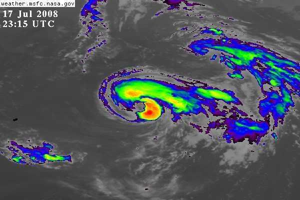
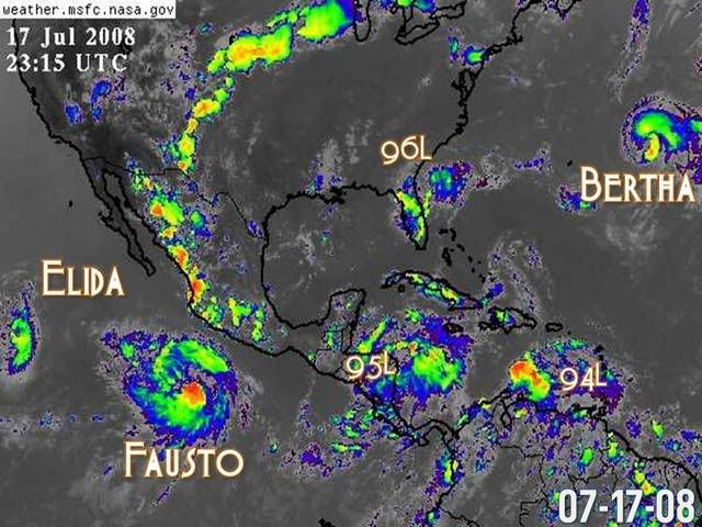
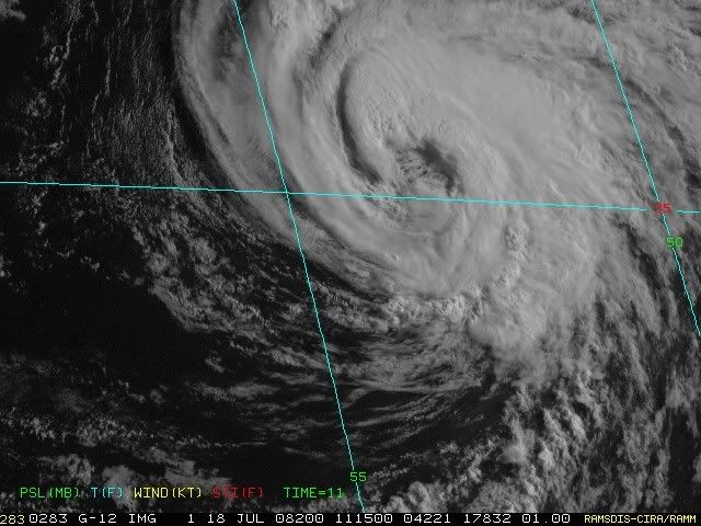
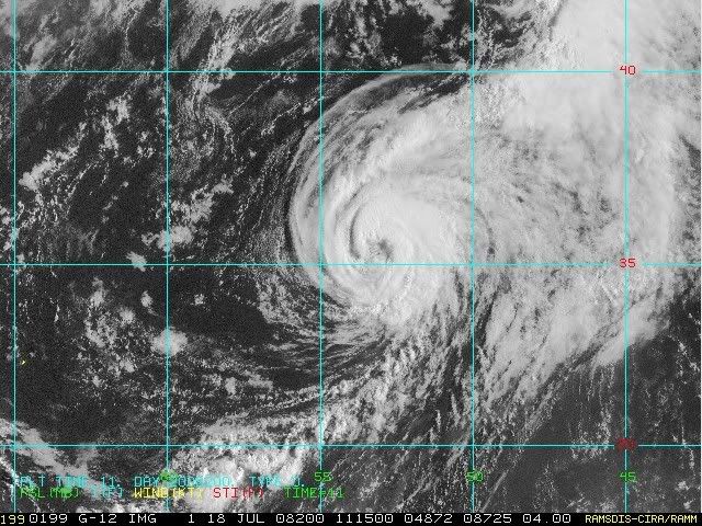
TROPICAL STORM BERTHA DISCUSSION NUMBER 58
NWS TPC/NATIONAL HURRICANE CENTER MIAMI FL AL022008
1100 AM EDT THU JUL 17 2008

BERTHA COULD BECOME ONE OF THE TOP 10 LONGEST-LIVED STORMS IN
HISTORY IF IT SURVIVES UNTIL THE WEEKEND.
0 likes   

User avatar
KWT
Category 5
Category 5
Posts: 31415
Joined: Tue Aug 17, 2004 11:02 am
Location: UK!!!

#4230 Postby KWT » Thu Jul 17, 2008 3:48 pm

Probably the biggest threat to its survival till Sunday wil be the extra tropical transition, I suspect its going to fall just a little bit short of that right now but I may be wrong!
0 likes   

User avatar
HURAKAN
Professional-Met
Professional-Met
Posts: 46086
Age: 38
Joined: Thu May 20, 2004 4:34 pm
Location: Key West, FL
Contact:

#4231 Postby HURAKAN » Thu Jul 17, 2008 4:01 pm

TROPICAL STORM BERTHA DISCUSSION NUMBER 59
NWS TPC/NATIONAL HURRICANE CENTER MIAMI FL AL022008
500 PM EDT THU JUL 17 2008

SATELLITE IMAGES INDICATE THAT BERTHA IS MAINTAINING ITS STRUCTURE
AS A TROPICAL STORM WITH DEFINED BANDING FEATURES AND OUTFLOW
ALOFT. CONVECTION HAS BEEN WELL-MAINTAINED...ESPECIALLY IN THE
NORTHEAST QUADRANT OF THE STORM. THERE HAS BEEN NO CHANGE IN THE
SATELLITE CLASSIFICATIONS SO THE INITIAL INTENSITY WILL REMAIN 50
KT. NO SIGNIFICANT INTENSITY FLUCTUATIONS ARE EXPECTED DURING THE
NEXT DAY OR SO AS THE STORM REMAINS UNDER THE INFLUENCE OF MODERATE
SHEAR AND WANING SSTS. THE EXTRATROPICAL TRANSITION PROCESS SHOULD
START SHORTLY AFTER 48 HR DUE TO AN INCREASE IN SHEAR AND MORE
RAPIDLY DECREASING SSTS...AND BY 120 HR...THE REMNANTS OF BERTHA
WILL LIKELY BE ABSORBED INTO A LARGER EXTRATROPICAL LOW.

THE STORM HAS MADE AN EASTWARD TURN AND IS MOVING ABOUT 090/10. A
BUILDING RIDGE TO THE EAST OF BERTHA SHOULD STEER THE STORM MORE TO
THE NORTHEAST TOMORROW...FOLLOWING CLOSE BEHIND A MIDDLE- TO
UPPER-LEVEL LOW TO ITS NORTH. MODEL GUIDANCE IS TIGHTLY CLUSTERED
ON AN ACCELERATING PATH OUT TO SEA. THE GFS HAS CHANGED FROM THE
SOUTH TO NORTH SIDE OF THE MODEL CONSENSUS...NOW SHOWING MORE
INTERACTION WITH A NEW MIDDLE-LATITUDE TROUGH IN A COUPLE OF DAYS.
THE OFFICIAL FORECAST LIES ON THE LEFT SIDE OF THE CONSENSUS AND IS
PRETTY CLOSE TO THE PREVIOUS ONE.

TO CLARIFY A PREVIOUS DISCUSSION COMMENT...BERTHA COULD BECOME ONE
OF THE TOP 10 LONGEST-LIVED ATLANTIC STORMS...IN TERMS OF DAYS AS A
TROPICAL STORM OR GREATER...IF IT SURVIVES UNTIL SUNDAY.


FORECAST POSITIONS AND MAX WINDS

INITIAL 17/2100Z 34.0N 57.2W 50 KT
12HR VT 18/0600Z 34.4N 55.6W 45 KT
24HR VT 18/1800Z 35.9N 53.3W 45 KT
36HR VT 19/0600Z 37.8N 51.0W 45 KT
48HR VT 19/1800Z 39.9N 48.3W 45 KT
72HR VT 20/1800Z 45.0N 41.0W 50 KT...EXTRATROPICAL
96HR VT 21/1800Z 53.5N 30.0W 50 KT...EXTRATROPICAL
120HR VT 22/1800Z...ABSORBED

$$
FORECASTER BLAKE
0 likes   

User avatar
HURAKAN
Professional-Met
Professional-Met
Posts: 46086
Age: 38
Joined: Thu May 20, 2004 4:34 pm
Location: Key West, FL
Contact:

#4232 Postby HURAKAN » Thu Jul 17, 2008 5:08 pm

Image

Yes, that's long-lived Bertha.
0 likes   

User avatar
KWT
Category 5
Category 5
Posts: 31415
Joined: Tue Aug 17, 2004 11:02 am
Location: UK!!!

#4233 Postby KWT » Thu Jul 17, 2008 5:11 pm

Have to admit this is a really impressive system, Bertha certainly has been one for the history books just like its older sibliing...Bertha 96.
0 likes   

User avatar
HURAKAN
Professional-Met
Professional-Met
Posts: 46086
Age: 38
Joined: Thu May 20, 2004 4:34 pm
Location: Key West, FL
Contact:

#4234 Postby HURAKAN » Thu Jul 17, 2008 6:46 pm

Image

Heavy convection developing over the SE quadrant.
0 likes   

User avatar
HURAKAN
Professional-Met
Professional-Met
Posts: 46086
Age: 38
Joined: Thu May 20, 2004 4:34 pm
Location: Key West, FL
Contact:

#4235 Postby HURAKAN » Thu Jul 17, 2008 7:05 pm

Image

The big picture.
0 likes   

User avatar
gotoman38
Category 5
Category 5
Posts: 1395
Joined: Fri Sep 12, 2003 1:15 pm
Location: near Durham, NC

Re: Tropical Storm Bertha in Western Atlantic

#4236 Postby gotoman38 » Thu Jul 17, 2008 8:53 pm

Big Bertha is kickin the L to her NE up N now and building E - impressive

Image
0 likes   

User avatar
HURAKAN
Professional-Met
Professional-Met
Posts: 46086
Age: 38
Joined: Thu May 20, 2004 4:34 pm
Location: Key West, FL
Contact:

#4237 Postby HURAKAN » Fri Jul 18, 2008 5:14 am

Image

Bertha is not letting go.
0 likes   

User avatar
KWT
Category 5
Category 5
Posts: 31415
Joined: Tue Aug 17, 2004 11:02 am
Location: UK!!!

#4238 Postby KWT » Fri Jul 18, 2008 5:16 am

Woah Bertha still looking real good right now, even the NHC states:

"THE INITIAL INTENSITY IS KEPT AT 50
KNOTS...BUT IT COULD BE A LITTLE BIT STRONGER."
0 likes   

User avatar
HURAKAN
Professional-Met
Professional-Met
Posts: 46086
Age: 38
Joined: Thu May 20, 2004 4:34 pm
Location: Key West, FL
Contact:

#4239 Postby HURAKAN » Fri Jul 18, 2008 6:52 am

Image

Image

Looking good.
0 likes   

User avatar
cycloneye
Admin
Admin
Posts: 145302
Age: 68
Joined: Thu Oct 10, 2002 10:54 am
Location: San Juan, Puerto Rico

Re: Tropical Storm Bertha in Western Atlantic

#4240 Postby cycloneye » Fri Jul 18, 2008 6:55 am

Amazing!
0 likes   


Return to “2008”

Who is online

Users browsing this forum: No registered users and 7 guests