

Wow tornado moving at 85 mph. Don't think I've ever seen that before.
Severe Weather Statement
National Weather Service Newport/Morehead City NC
751 PM EDT THU SEP 13 2018
NCC031-049-140015-
/O.CON.KMHX.TO.W.0006.000000T0000Z-180914T0015Z/
Craven NC-Carteret NC-
751 PM EDT THU SEP 13 2018
...A TORNADO WARNING REMAINS IN EFFECT UNTIL 815 PM EDT FOR
SOUTHEASTERN CRAVEN AND WEST CENTRAL CARTERET COUNTIES...
At 750 PM EDT, a severe thunderstorm capable of producing a tornado
was located over Great Neck, or 11 miles east of Havelock, moving
southwest at 85 mph.
HAZARD...Tornado.
SOURCE...Radar indicated rotation.
IMPACT...Flying debris will be dangerous to those caught without
shelter. Mobile homes will be damaged or destroyed. Damage
to roofs, windows, and vehicles will occur. Tree damage is
likely.
This dangerous storm will be near...
North Harlowe and Cherry Branch Ferry Terminal around 755 PM EDT.
Havelock and Newport around 800 PM EDT.
Broad Creek around 805 PM EDT.
ATL: FLORENCE - Post-Tropical - Discussion
Moderator: S2k Moderators
Re: ATL: FLORENCE - Hurricane - Discussion
meriland29 wrote:
Would that mean disruption or ERC?
There is no real eyewall to replace. Florence isn't the well put together major cane she was yesterday morning. As is generally the case with major storms after they encounter a protracted period of adverse conditions or a big landmass...there's generally no putting humpty dumpty back together again. (Gustav and Ike are good examples). She is a large spread out system and likely to remain so. Accordingly, modest changes in central pressure that would usually bump the intensity needle in other storms are unlikely to do so here. (Full disclosure...Flo has fooled me in the past)
1 likes

Re: ATL: FLORENCE - Hurricane - Discussion
Raebie wrote:I'm really surprised at the lack of tornados so far. Still too far offshore?
Well, it's 2018 after all.
This year is to tornados like 2013 was for atlantic hurricanes.
4 likes
-
wxman57

- Moderator-Pro Met

- Posts: 23175
- Age: 68
- Joined: Sat Jun 21, 2003 8:06 pm
- Location: Houston, TX (southwest)
Re: ATL: FLORENCE - Hurricane - Discussion
Recon is finding about 75 kts, possibly up to 80, making it a cat 1. That remnant eye wobbling around in a partial outer eyewall reminds me of Ike in 2008.
3 likes
-
meriland29

- Category 2

- Posts: 770
- Joined: Thu Aug 03, 2017 11:05 am
-
dukeblue219
- S2K Supporter

- Posts: 556
- Joined: Fri Sep 30, 2016 3:52 pm
Re: ATL: FLORENCE - Hurricane - Discussion
meriland29 wrote:Thought she was up to 105?
The 7pm update was corrected with an amended advisory. Sincd that happened, the 8pm is out and is correct at 100mph.
That said, it's simply the NHC's best figure for what the highest sustained winds are at a specific time. A hurricane is constantly varying to some extent, especially when interacting with land.
Last edited by dukeblue219 on Thu Sep 13, 2018 7:13 pm, edited 1 time in total.
0 likes
Re: ATL: FLORENCE - Hurricane - Discussion
meriland29 wrote:Thought she was up to 105?
Back down to 100 officially
0 likes

Re: ATL: FLORENCE - Hurricane - Discussion
tolakram wrote:meriland29 wrote:
Would that mean disruption or ERC?
The ERC never finished, and just like Ike, Florence is too big to really clear it out or intensify as far as wind speed goes. The wind field is expanding, meaning surge potential is rising. People keep focusing on raw wind speed which doesn't mean much of anything at this point. I liken it to water in a bathtub. Use only one finger and make a spinning motion as fast as you can, cat 5 speed, with just one finger. Now use your entire hand but go slower. You are moving a LOT more water.
I'm guilty of over comparing this to Ike, and Ike was in the gulf which can be more prone to surge because of the shape, but I feel like surge here along the coast is going to be really bad. Any drop in pressure most likely translates to a very small increase in wind speed over a very large area (rather than just a tiny eyewall).
That holds true for wind damage from slow moving storms as well, its energy expended over time that does wind roof damage. Trees roots don't do well in mud from extended rainfall either. Hope that troichodal motion doesn't leave these poor folks exposed for days.
1 likes
Re: ATL: FLORENCE - Hurricane - Discussion
8:00 PM:
33.9N 76.4W
100 MPH
Movement NW 5 mph
was NW movement predicted at this time?
33.9N 76.4W
100 MPH
Movement NW 5 mph
was NW movement predicted at this time?
0 likes

Re: ATL: FLORENCE - Hurricane - Discussion
NWS Wilmington NC Retweeted
NWS Eastern Region
NWS Eastern Region
@NWSEastern
·
32m
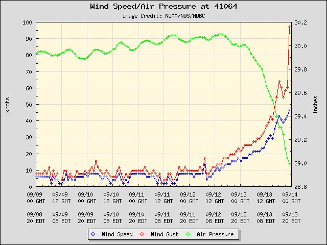
Wind gust of 97 knots or 112 mph at buoy 41064 located 30 miles southeast of New River Inlet NC.
NWS Eastern Region
NWS Eastern Region
@NWSEastern
·
32m
Wind gust of 97 knots or 112 mph at buoy 41064 located 30 miles southeast of New River Inlet NC.
0 likes
-
dukeblue219
- S2K Supporter
- Posts: 556
- Joined: Fri Sep 30, 2016 3:52 pm
Re: ATL: FLORENCE - Hurricane - Discussion
wx98 wrote:meriland29 wrote:Thought she was up to 105?
Back down to 100 officially
It was never 105mph. Not sure if the amendment was posted here but 7pm was incorrect briefly and fixed. They rarely update winds during those position updates unless there's major changes.
1 likes

Re: ATL: FLORENCE - Hurricane - Discussion
meriland29 wrote:Thought she was up to 105?
They dropped her back to 100. and pressure at 955, moving NW at 5 (supposedly)
0 likes
Personal Forecast Disclaimer:
The posts in this forum are NOT official forecast and should not be used as such. They are just the opinion of the poster and may or may not be backed by sound meteorological data. They are NOT endorsed by any professional institution or storm2k.org. For official information, please refer to the NHC and NWS products.
The posts in this forum are NOT official forecast and should not be used as such. They are just the opinion of the poster and may or may not be backed by sound meteorological data. They are NOT endorsed by any professional institution or storm2k.org. For official information, please refer to the NHC and NWS products.
-
MidnightRain

- Tropical Storm

- Posts: 110
- Joined: Tue Oct 11, 2011 8:26 pm
- Location: NW Florida
Re: ATL: FLORENCE - Hurricane - Discussion
Not a wise idea to be judging this by category. A large windfield and a widespread threat of storm surge along the coast, not a good setup. Some areas may experience tropical storm/hurricane conditions for a long time, this is not the usual situation when a storm is generally in and out in a matter of a few hours. Going to be a scary night for those in the Carolinas.
6 likes
The posts in this forum are NOT official forecast and should not be used as such. They are just the opinion of the poster and may or may not be backed by sound meteorological data. They are NOT endorsed by any professional institution or storm2k.org. For official information, please refer to the NHC and NWS products.
-
Rail Dawg
- S2K Supporter
- Posts: 326
- Joined: Mon Aug 27, 2012 5:02 pm
- Location: Where the eye makes landfall.
Re: ATL: FLORENCE - Hurricane - Discussion
Well this is what makes hurricane chasing so interesting.
Took the last available Econo Lodge motel room just east of Columbia, SC.
Gonna take the first shower in 5 days. Already refilled all the diesel and grabbed a few extra gallons of water.
Tomorrow morning early will look at this thing and decide whether to head back into the zone or keep bailing to Houston.
After 30 years chasing every major hurricane one learns that just when we think we know what we’re doing the hurricane will dictate otherwise.
6 likes
Although I have been a hurricane forecaster since 1980 that only means I've been wrong lots of times.
-
AnnularCane

- S2K Supporter
- Posts: 2964
- Joined: Thu Jun 08, 2006 9:18 am
- Location: Wytheville, VA
Re: ATL: FLORENCE - Hurricane - Discussion
MidnightRain wrote:Not a wise idea to be judging this by category. A large windfield and a widespread threat of storm surge along the coast, not a good setup. Some areas may experience tropical storm/hurricane conditions for a long time, this is not the usual situation when a storm is generally in and out in a matter of a few hours. Going to be a scary night for those in the Carolinas.
I'm already seeing "it's only a 2" posts. Not here (I don't think), but elsewhere.
4 likes
Re: ATL: FLORENCE - Hurricane - Discussion
NOAA NSSL
NOAA NSSL
@NOAANSSL
·
13m
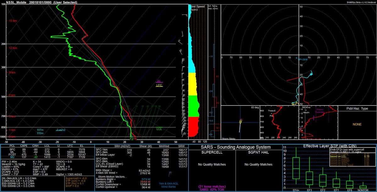
Sounding from 2244 UTC near Wilmington, NC
@NWSSPC
@NWSWilmingtonNC
@NWSRaleigh
@NWSMoreheadCity
@NHC_Atlantic
@HRD_AOML_NOAA
#hurricaneFlorence
Data is preliminary, experimental,
0 likes
-
AdamFirst

- S2K Supporter
- Posts: 2490
- Age: 36
- Joined: Thu Aug 14, 2008 10:54 am
- Location: Port Saint Lucie, FL
Re: ATL: FLORENCE - Hurricane - Discussion
Rail Dawg wrote:Well this is what makes hurricane chasing so interesting.
Took the last available Econo Lodge motel room just east of Columbia, SC.
Gonna take the first shower in 5 days. Already refilled all the diesel and grabbed a few extra gallons of water.
Tomorrow morning early will look at this thing and decide whether to head back into the zone or keep bailing to Houston.
After 30 years chasing every major hurricane one learns that just when we think we know what we’re doing the hurricane will dictate otherwise.
I wouldn't want to be trapped in this mess, the 'dirty storm' like you mentioned. Made the wise decision of getting out while you can. The surge is going to get ugly tonight on the coast and the flooding could very well trap you in the woods.
1 likes
Dolphins Marlins Canes Golden Panthers HEAT
Andrew 1992 - Irene 1999 - Frances 2004 - Jeanne 2004 - Wilma 2005 - Fay 2008 - Isaac 2012 - Matthew 2016 - Irma 2017 - Dorian 2019 - Ian 2022 - Nicole 2022 - Milton 2024
Andrew 1992 - Irene 1999 - Frances 2004 - Jeanne 2004 - Wilma 2005 - Fay 2008 - Isaac 2012 - Matthew 2016 - Irma 2017 - Dorian 2019 - Ian 2022 - Nicole 2022 - Milton 2024

Re: ATL: FLORENCE - Hurricane - Discussion

Drop with 86kt in lowest 150m
1 likes
Kendall -> SLO -> PBC
Memorable Storms: Katrina (for its Florida landfall...) Wilma Matthew Irma
Memorable Storms: Katrina (for its Florida landfall...) Wilma Matthew Irma

Re: ATL: FLORENCE - Hurricane - Discussion
CNN showed some downtown flooding in New Bern. Surge is high there but will get worse. Most reporters are off the islands, so there isn’t that much network coverage I can find but inside the intercoastal and from cities on the mainland. But you’d have to think that it’s about to get real for a day and a half to two days in parts of SE NC. With the storm not moving much and the direct onshore flow, not only can you not sleep on surge and its duration, but you have to seriously consider inland flooding due to wave after wave of rain. Hopefully some of the locals will go live and get some raw footage out there over the days 2 days.
Last edited by Steve on Thu Sep 13, 2018 7:30 pm, edited 2 times in total.
2 likes
Re: ATL: FLORENCE - Hurricane - Discussion
Brendan King CBS 6
Brendan King CBS 6
@ImBrendanKing
·
17m
RIGHT NOW: The ABC station in
#NewBern
was live on the air when they decided to evacuate due to flooding
Quote Tweet
JaimeMcCutcheon-WCTI
@jaimemccutcheon
So that really did just happen. The water started rising and we evacuated almost an entire TV station in about 15 minutes.
1 likes
Who is online
Users browsing this forum: No registered users and 138 guests