Global model runs discussion

Moderator: S2k Moderators

Message
Author
User avatar
ROCK
Category 5
Category 5
Posts: 9484
Age: 54
Joined: Tue Aug 17, 2004 7:30 am
Location: Kemah, Texas

Re: Global Model Runs Discussion

#4281 Postby ROCK » Mon Sep 03, 2012 1:38 am

Hurricaneman wrote:around 5 to 6 days from now the GFS shows a low forming in North Carolina and sliding offshore, could this be some homebrew tropical system, the poster somethingfunny picked out that possibility


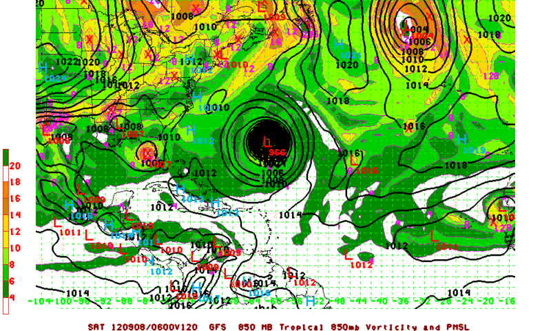
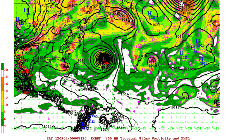
The EURO take the vort from Isacc across Florida and into the EGOM now....1008MB....at 120hr
0 likes   

User avatar
ROCK
Category 5
Category 5
Posts: 9484
Age: 54
Joined: Tue Aug 17, 2004 7:30 am
Location: Kemah, Texas

Re: Global Model Runs Discussion

#4282 Postby ROCK » Mon Sep 03, 2012 1:42 am

0Z NOGAPS is latching on to the low the EURO has in the medium range coming off of Africa

https://www.fnmoc.navy.mil/wxmap_cgi/cg ... t=Tropical
0 likes   

User avatar
NDG
S2K Supporter
S2K Supporter
Posts: 15446
Joined: Sun Jul 09, 2006 10:14 pm
Location: Orlando, FL

#4283 Postby NDG » Mon Sep 03, 2012 7:19 am

Both the Euro and GFS show the remnants of Isaac, or a piece of it, moving back to the NE GOM redeveloping, weak, then moving eastward across the Peninsula being picked up a trough at the end of the week.
The euro has been showing this solution off and on during the last couple days.

Image
Image
0 likes   

rainstorm

#4284 Postby rainstorm » Mon Sep 03, 2012 7:31 am

how does isaacs remains get all the way down there?
0 likes   

User avatar
NDG
S2K Supporter
S2K Supporter
Posts: 15446
Joined: Sun Jul 09, 2006 10:14 pm
Location: Orlando, FL

Re:

#4285 Postby NDG » Mon Sep 03, 2012 7:52 am

rainstorm wrote:how does isaacs remains get all the way down there?


It gets caught by the clockwise rotation of the ridge over TX sending it straight south towards the GOM.
0 likes   

HurricaneFan
Tropical Storm
Tropical Storm
Posts: 192
Age: 41
Joined: Tue Jan 18, 2011 6:16 pm
Location: Anguilla,Leeward Islands 18.3N 63.0W

Re: Global Model Runs Discussion

#4286 Postby HurricaneFan » Mon Sep 03, 2012 9:27 am

There looks to be a Tropical Wave between 30W and 35W flaring up a lot right now.
Are any models starting to pick up on this system for development?
And what track are they hinting at now?Will it follow Leslie or will it make it to the Lesser Antilles?
0 likes   

User avatar
Hurricane Alexis
Category 2
Category 2
Posts: 683
Age: 29
Joined: Thu Jun 14, 2012 7:59 pm
Location: Miami,Florida

Re: Global Model Runs Discussion

#4287 Postby Hurricane Alexis » Mon Sep 03, 2012 10:00 am

06z GFS also shows Isaac's remnants redeveloping a little, then crossing the peninsula.

Image

Extremely long range GFS.

Image
0 likes   
Personal Forecast Disclaimer:
The posts in this forum are NOT official forecast and should not be used as such. They are just the opinion of the poster and may or may not be backed by sound meteorological data. They are NOT endorsed by any professional institution or storm2k.org. For official information, please refer to the NHC and NWS products.

rainstorm

#4288 Postby rainstorm » Mon Sep 03, 2012 12:40 pm

http://tc.met.psu.edu/tcgengifs/GFS/201 ... /slp47.png

gfs shows another recurve, ugh. but with a high over se canada and a trough in the central plains it would probably end up further west. of course, 18z will be completely different in any case.
0 likes   

User avatar
ROCK
Category 5
Category 5
Posts: 9484
Age: 54
Joined: Tue Aug 17, 2004 7:30 am
Location: Kemah, Texas

Re: Global Model Runs Discussion

#4289 Postby ROCK » Mon Sep 03, 2012 6:36 pm

EURO was interesting.....if Isaas does drop off AL/MS as progged and doesnt get picked up by the trof then it will follow the IVAN II track....back into LA possibly.....what a double whammy if that were to happen!!
0 likes   

rainstorm

#4290 Postby rainstorm » Mon Sep 03, 2012 8:05 pm

as expected the 18z totally changed. hurricane to miami on this run

http://tc.met.psu.edu/tcgengifs/GFS/201 ... /slp47.png
0 likes   

Floridaman
Tropical Wave
Tropical Wave
Posts: 9
Age: 32
Joined: Tue Aug 28, 2012 12:54 pm
Location: Key West, Florida

Re:

#4291 Postby Floridaman » Mon Sep 03, 2012 8:13 pm

rainstorm wrote:as expected the 18z totally changed. hurricane to miami on this run

http://tc.met.psu.edu/tcgengifs/GFS/201 ... /slp47.png


What storm would this be?
0 likes   

User avatar
Hurricane Alexis
Category 2
Category 2
Posts: 683
Age: 29
Joined: Thu Jun 14, 2012 7:59 pm
Location: Miami,Florida

Re: Re:

#4292 Postby Hurricane Alexis » Mon Sep 03, 2012 8:17 pm

Floridaman wrote:
rainstorm wrote:as expected the 18z totally changed. hurricane to miami on this run

http://tc.met.psu.edu/tcgengifs/GFS/201 ... /slp47.png


What storm would this be?


Michael or Nadine, or maybe Oscar.
0 likes   
Personal Forecast Disclaimer:
The posts in this forum are NOT official forecast and should not be used as such. They are just the opinion of the poster and may or may not be backed by sound meteorological data. They are NOT endorsed by any professional institution or storm2k.org. For official information, please refer to the NHC and NWS products.

jaxfladude
Category 5
Category 5
Posts: 1249
Joined: Wed Aug 24, 2005 9:36 pm
Location: Jacksonville, Fla

#4293 Postby jaxfladude » Mon Sep 03, 2012 9:01 pm

I do not like some of these models, too many chances of another U.S.A. hit or any one else for that matter.....albeit long range models
I want the "Shut Down" ASAP!
--------------
The posts in this forum are NOT official forecast and should not be used as such. They are just the opinion of the poster and may or may not be backed by sound meteorological data. They are NOT endorsed by any professional institution or storm2k.org. For official information, please refer to the NHC and NWS products.
0 likes   
Stay safe y'all

User avatar
somethingfunny
ChatStaff
ChatStaff
Posts: 3926
Age: 37
Joined: Thu May 31, 2007 10:30 pm
Location: McKinney, Texas

Re: Global Model Runs Discussion

#4294 Postby somethingfunny » Tue Sep 04, 2012 1:07 am

0z GFS shows three little ducks lined up in a row.

Image
0 likes   
I am not a meteorologist, and any posts made by me are not official forecasts or to be interpreted as being intelligent. These posts are just my opinions and are probably silly opinions.

User avatar
somethingfunny
ChatStaff
ChatStaff
Posts: 3926
Age: 37
Joined: Thu May 31, 2007 10:30 pm
Location: McKinney, Texas

Re: Global Model Runs Discussion

#4295 Postby somethingfunny » Tue Sep 04, 2012 3:52 am

One of my favorite ways to check out the GFS at long range:

Image
0 likes   
I am not a meteorologist, and any posts made by me are not official forecasts or to be interpreted as being intelligent. These posts are just my opinions and are probably silly opinions.

rainstorm

#4296 Postby rainstorm » Tue Sep 04, 2012 7:03 am

0 likes   

User avatar
cycloneye
Admin
Admin
Posts: 145296
Age: 68
Joined: Thu Oct 10, 2002 10:54 am
Location: San Juan, Puerto Rico

Re:

#4297 Postby cycloneye » Tue Sep 04, 2012 7:14 am

rainstorm wrote:06z back to recurve.

http://tc.met.psu.edu/tcgengifs/GFS/201 ... /slp43.png


But not before it clips the Northern Leewards/VI/PR.
0 likes   
Visit the Caribbean-Central America Weather Thread where you can find at first post web cams,radars
and observations from Caribbean basin members Click Here

User avatar
ROCK
Category 5
Category 5
Posts: 9484
Age: 54
Joined: Tue Aug 17, 2004 7:30 am
Location: Kemah, Texas

Re: Global Model Runs Discussion

#4298 Postby ROCK » Tue Sep 04, 2012 12:10 pm

I seem to recall someone saying that there would not be as many storms in Sept than August....Well Michael is one....the 12ZGFS already sniffing out 2 canidates in the med/ short range.... :wink:
0 likes   

rainstorm

Re: Global Model Runs Discussion

#4299 Postby rainstorm » Tue Sep 04, 2012 12:24 pm

ROCK wrote:I seem to recall someone saying that there would not be as many storms in Sept than August....Well Michael is one....the 12ZGFS already sniffing out 2 canidates in the med/ short range.... :wink:


where?
0 likes   

rainstorm

#4300 Postby rainstorm » Tue Sep 04, 2012 12:48 pm

meanwhile, 12z has once again brought back the threat of an east coast cane.

http://tc.met.psu.edu/tcgengifs/GFS/201 ... /slp47.png
0 likes   


Return to “2015”

Who is online

Users browsing this forum: No registered users and 6 guests