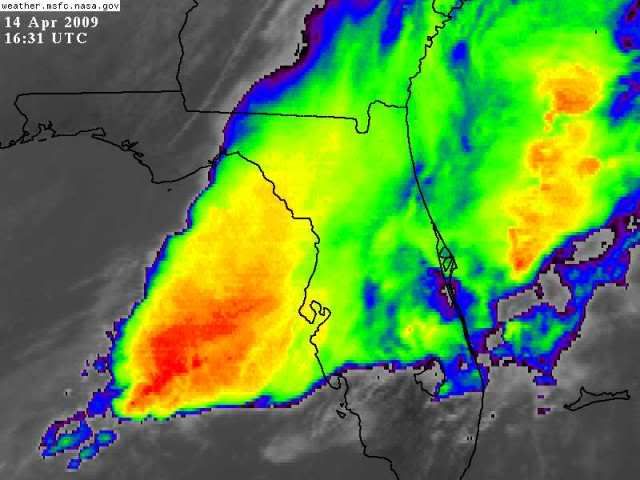
LOL my 630 estimate was 2 hours 2 early- but not bad for an amateur!!!
I have been tracking the same supercell all morning- it should hit Pinellas
coast around 815 AM by that radar above
Florida Weather
Moderator: S2k Moderators
Forum rules

The posts in this forum are NOT official forecast and should not be used as such. They are just the opinion of the poster and may or may not be backed by sound meteorological data. They are NOT endorsed by any professional institution or STORM2K.
-
Tampa Bay Hurricane

- Category 5

- Posts: 5597
- Age: 38
- Joined: Fri Jul 22, 2005 7:54 pm
- Location: St. Petersburg, FL
-
Tampa Bay Hurricane
- Category 5
- Posts: 5597
- Age: 38
- Joined: Fri Jul 22, 2005 7:54 pm
- Location: St. Petersburg, FL

Re: Florida Weather Thread:warming, have/have nots in rain conti
Sever T-storm Warning. Pinellas, Pasco, Hillsborough, Hernando.
0 likes
-
feederband

- S2K Supporter

- Posts: 3423
- Joined: Wed Oct 01, 2003 6:21 pm
- Location: Lakeland Fl
Re: Florida Weather Thread:warming, have/have nots in rain conti
Big thunderstrom rolling in right now...Nice to hear the thunder again...Hope nobody gets beat up though.
0 likes
-
JonathanBelles
- Professional-Met

- Posts: 11430
- Age: 35
- Joined: Sat Dec 24, 2005 9:00 pm
- Location: School: Florida State University (Tallahassee, FL) Home: St. Petersburg, Florida
- Contact:
Re: Florida Weather Thread:warming, have/have nots in rain conti
Doesn't appear to be plunging. Not sure if it will make it here. Hazy, partly sunny 80*
0 likes
-
Ed Mahmoud
Re: Florida Weather Thread:warming, have/have nots in rain conti
Is Mr. C working NWS MLB today?
SEVERE WEATHER STATEMENT
NATIONAL WEATHER SERVICE MELBOURNE FL
1046 AM EDT TUE APR 14 2009
FLC095-141500-
/O.CON.KMLB.TO.W.0005.000000T0000Z-090414T1500Z/
ORANGE-
1046 AM EDT TUE APR 14 2009
...A TORNADO WARNING REMAINS IN EFFECT UNTIL 1100 AM EDT FOR
SOUTHEASTERN ORANGE COUNTY...
AT 1043 AM EDT...NATIONAL WEATHER SERVICE DOPPLER RADAR CONTINUED TO
INDICATE A TORNADO. THIS STORM WAS LOCATED 10 MILES WEST OF LONE
CABBAGE FISH CAMP. THE STORM WAS MOVING EAST AT 35 MPH.
THOSE ACROSS SOUTHEAST SECTIONS OF ORANGE COUNTY SHOULD SEEK SAFE
SHELTER.
0 likes
Re:
NWS Miami not forecasting much in the way of precip this far south....10% chance of rain today, increases to 20% tonight and then decreases again....no severe weather mentioned...and as is often the case this time of year....regardless of temps around 90...if the energy of these systems bypasses south florida, severe weather just isn't going to happen.
What source did you get info on cold pool of air resulting in severe weather in south florida today? NWS Miami calling for mostly dry day....let alone severe weather.
THE NAM-WRF IS A GOOD MODEL MUCH OF THE TIME...BUT IT WAS OUT TO
LUNCH SUNDAY...OUT TO LUNCH MONDAY...AND BELIEVE IT IS STILL OUT
TO LUNCH FOR THIS AFTERNOON (LONG LUNCH!). IT LOOKS TOO AGGRESSIVE
AGAIN WITH CONVECTION DEVELOPING...ESPECIALLY SINCE THE AREA WILL
BE IN A STRONG S-SW WIND FLOW WITH NO SEA BREEZES PRESENT AND THUS
NO CONVERGENCE. SO WILL FOLLOW THE GFS...AS IT HAS BEEN HANDLING
THINGS BETTER THAN THE NAM AND NAM-WRF RECENTLY WITH REGARDS TO
THE MOISTURE FIELDS AND INSTABILITY. DUE TO THE LACK OF
CONVERGENCE...BELIEVE MOST (IF NOT ALL) AREAS WILL REMAIN DRY
THROUGH THIS AFTERNOON. HOWEVER...WILL CARRY SLIGHT CHANCE POPS
ACROSS THE AREA TODAY GIVEN THAT INSTABILITY WILL BE
INCREASING...AS WELL AS THE POSSIBILITY FOR CONVECTION FROM
CENTRAL FL AFFECTING NW AREAS VERY LATE IN THE DAY.
HOWEVER...AGAIN...BEST BET IS THAT IT WILL REMAIN DRY TODAY...AND
THUS ONLY THE SLIGHT CHANCE POPS.
COLD FRONT FINALLY REACHES THE AREA ON WEDNESDAY BUT BY THEN
ENERGY LIFTS FURTHER AWAY AND SO WE ARE LEFT WITH PROSPECTS OF
ISOLATED SHOWERS AND PERHAPS A THUNDERSTORM MAINLY ACROSS THE
SOUTHERN HALF OF THE AREA. THE FRONT IS SLOW TO MOVE OFF THE COAST
WED NIGHT...FINALLY SOUTH OF THE AREA BY THU WITH STRONG HIGH
PRESSURE BUILDING DOWN THE EASTERN SEABOARD FOR THE LATTER PART OF
THE WEEK. THIS RESULTS IN A PERIOD OF A COOLING/DRYING NE WIND
FLOW THROUGH SATURDAY WITH DEWPOINTS DROPPING INTO THE 50S. WINDS
BEGIN TO SWING AROUND TO SE BY SUN/MON AS ANOTHER SHORTWAVE DIVES
SE FROM THE CENTRAL STATES. BOTH GFS/ECMWF AGREE IN ANOTHER
FRONTAL PASSAGE A WEEK FROM TODAY.
Tampa Bay Hurricane wrote:Line of storms dissappated- BUST!!!
BUT there is HOPE!!!!
A large supercell cluster is about 200 miles west of
Tampa Bay and should arrive by 630 AM in the morning
ROCK AND ROLL BABY!!!! Let's GET SOME ACTION COME
ON!!!!!!!!!!!!
Also, with daytime heating and temperatures in the low
90s south florida could see some big storms tomorrow- as in
severe. Very cold pocket of air aloft tommorrow will fuel
severe thunderstorms over South Florida.
0 likes
-
Tampa Bay Hurricane
- Category 5
- Posts: 5597
- Age: 38
- Joined: Fri Jul 22, 2005 7:54 pm
- Location: St. Petersburg, FL
I had some wind gusts that looked like about 50 mph earlier- lasted
only a few seconds but it was very strong- conditions were like
that of a tropical storm. But it was wrapped in heavy rain- so it
was very hard to see- therefore my wind estimate may be
inaccurate. A lot of lightning is occuring still.
60 mph winds just north of me:
04/14/2009 0823 am
N Tarpon Springs, Pinellas County.
Thunderstorm wind gust e60.00 mph, reported by Fire Dept/Rescue.
Trees and power lines down in north Tarpon Springs.
0 likes
-
Tampa Bay Hurricane
- Category 5
- Posts: 5597
- Age: 38
- Joined: Fri Jul 22, 2005 7:54 pm
- Location: St. Petersburg, FL
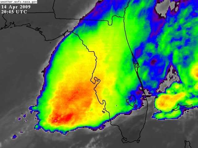
Re: Florida Weather Thread:warming, have/have nots in rain conti
From Fox 13 Tampa Bay News:
http://www.myfoxtampabay.com
Storm Damage:

Source: Fox 13 News Tampa Bay

Source: Fox 13 News Tampa Bay

Source: Fox 13 News Tampa Bay
http://www.myfoxtampabay.com
Storm Damage:

Source: Fox 13 News Tampa Bay

Source: Fox 13 News Tampa Bay

Source: Fox 13 News Tampa Bay
0 likes
Re: Florida Weather Thread:warming, have/have nots in rain conti
Plunging now. Think we'll get rain.
0 likes

-
Evil Jeremy

- S2K Supporter
- Posts: 5463
- Age: 32
- Joined: Mon Apr 10, 2006 2:10 pm
- Location: Los Angeles, CA
Re: Florida Weather Thread:warming, have/have nots in rain conti
Why is the NWS sticking a 20% of rain on Broward County? That mass of rain is huge and storms are already forming in SFl.
0 likes
Re: Florida Weather Thread:warming, have/have nots in rain conti
Storm about to move offshore ne broward
FLZ068-072-168-172-141745-
METRO PALM BEACH COUNTY FL-COASTAL PALM BEACH COUNTY FL-
METRO BROWARD COUNTY FL-COASTAL BROWARD COUNTY FL-
119 PM EDT TUE APR 14 2009
...STRONG THUNDERSTORM MOVING ACROSS DEERFIELD AND POMPANO BEACHES...
AT 117 PM EDT...NATIONAL WEATHER SERVICE DOPPLER RADAR INDICATED A
STRONG THUNDERSTORM NEAR POMPANO BEACH...MOVING NORTHEAST AT 20 MPH.
THIS STORM WILL AFFECT...
DEERFIELD BEACH...
NORTH POMPANO BEACH...
HILLSBORO BEACH...
AND SURROUNDING COMMUNITIES.
FREQUENT TO EXCESSIVE LIGHTNING...GUSTY WINDS TO 40 MPH...PEA-SIZED
HAIL...TORRENTIAL DOWNPOURS...OR A COMBINATION OF THESE ARE POSSIBLE.
LIGHTNING IS THE NUMBER ONE WEATHER RELATED KILLER IN FLORIDA. TREES
AND OPEN SHELTERS OFFER NO PROTECTION. WIND GUSTS OF UP TO 50 MPH CAN
DOWN SMALL TREE LIMBS AND BRANCHES...AND BLOW AROUND UNSECURED SMALL
OBJECTS. SEEK SHELTER IN A SAFE BUILDING UNTIL THE STORM PASSES.
LAT...LON 2619 8011 2625 8025 2634 8016 2632 8007
TIME...MOT...LOC 1718Z 239DEG 19KT 2625 8015
0 likes
-
JonathanBelles
- Professional-Met
- Posts: 11430
- Age: 35
- Joined: Sat Dec 24, 2005 9:00 pm
- Location: School: Florida State University (Tallahassee, FL) Home: St. Petersburg, Florida
- Contact:
-
JonathanBelles
- Professional-Met
- Posts: 11430
- Age: 35
- Joined: Sat Dec 24, 2005 9:00 pm
- Location: School: Florida State University (Tallahassee, FL) Home: St. Petersburg, Florida
- Contact:
-
Tampa Bay Hurricane
- Category 5
- Posts: 5597
- Age: 38
- Joined: Fri Jul 22, 2005 7:54 pm
- Location: St. Petersburg, FL
Re: Florida Weather Thread:warming, have/have nots in rain conti
It is windy. Drove to USF Tampa for a class. Also powerlines are bent over from this morning's tropical storm force blasts, mainly over north Tampa just north of USF Tampa.
0 likes
-
Tampa Bay Hurricane
- Category 5
- Posts: 5597
- Age: 38
- Joined: Fri Jul 22, 2005 7:54 pm
- Location: St. Petersburg, FL
Re: Florida Weather Thread:warming, have/have nots in rain conti
SUSTAINED MEDIUM TROPICAL STORM FORCE WINDS:
S 47 GUST 54 MPH Tampa, FL:
http://www.wunderground.com/weatherstat ... KFLTAMPA47
S 47 GUST 54 MPH Tampa, FL:
http://www.wunderground.com/weatherstat ... KFLTAMPA47
0 likes
Re: Florida Weather Thread:warming, have/have nots in rain conti
Holiday, Florida damage was two tornadoes.
Front approaching now with much needed rain.
Front approaching now with much needed rain.
0 likes
Return to “USA & Caribbean Weather”
Who is online
Users browsing this forum: No registered users and 30 guests