Texas Winter 2014-2015

Winter Weather Discussion

Moderator: S2k Moderators

Forum rules

The posts in this forum are NOT official forecast and should not be used as such. They are just the opinion of the poster and may or may not be backed by sound meteorological data. They are NOT endorsed by any professional institution or STORM2K.

Help Support Storm2K
Message
Author
User avatar
TeamPlayersBlue
Category 5
Category 5
Posts: 3462
Joined: Tue Feb 02, 2010 1:44 am
Location: Denver/Applewood, CO

Re: Re:

#4361 Postby TeamPlayersBlue » Wed Feb 11, 2015 11:52 pm

Ntxw wrote:
TeamPlayersBlue wrote:I remember, i drove into Dallas at around 3pm and East of Dallas on 20 was NOT FUN. I did slide much at all, but the roads were completely covered. My sports sedan wasnt a big fan. I have a pic somewhere of my front grill encased in snow from the drive. I also remember how the snow NEVER quit till about 3 am. it was crazy.


It was very crazy. One aspect of this storm that stuck out with me was the power of the subtropical jet. The storm itself wasn't that strong nor was the moisture plume with it that great. The night before it kicked out, the intense STJ was drawn up and dumped a quick 2-4 inches before the system even arrived. The relentless impulses came from the STJ that brought wave after wave of precip until the main system arrived the night before it ended which by then we were already approaching the 10 inch mark. The actual system itself got us over the foot.


yeah it was the storm befoe the storm
0 likes   
Personal Forecast Disclaimer:
The posts in this forum are NOT official forecast and should not be used as such. They are just the opinion of the poster and may or may not be backed by sound meteorological data. They are NOT endorsed by any professional institution or storm2k.org. For official information, please refer to the NHC and NWS products.

User avatar
TeamPlayersBlue
Category 5
Category 5
Posts: 3462
Joined: Tue Feb 02, 2010 1:44 am
Location: Denver/Applewood, CO

#4362 Postby TeamPlayersBlue » Thu Feb 12, 2015 12:13 am

Also, serious question, when was the last time we had a good line of storms come through as a cold front comes in? Used to have them all the time, this year they are non existent. Maybe they will come back in the spring.
0 likes   
Personal Forecast Disclaimer:
The posts in this forum are NOT official forecast and should not be used as such. They are just the opinion of the poster and may or may not be backed by sound meteorological data. They are NOT endorsed by any professional institution or storm2k.org. For official information, please refer to the NHC and NWS products.

Brent
S2K Supporter
S2K Supporter
Posts: 38236
Age: 37
Joined: Sun May 16, 2004 10:30 pm
Location: Tulsa Oklahoma
Contact:

Re:

#4363 Postby Brent » Thu Feb 12, 2015 12:49 am

Ntxw wrote:Today and tomorrow marks the 5 year anniversary of the greatest snowfall in DFW history. Relive it through the infamous 2009/2010 Texas winter thread. One of the most prolific bust in NWS FW busts. From nothing to 1-2 inches while 2-4 inches was already on the ground. From the GFS showing Nada the night before while the NAM was the lonely dog. It kept coming and it kept piling, they finally said 4-6 inches while over 8" was already on the ground. May we relive those days again and again...

viewtopic.php?f=22&t=106895&st=0&sk=t&sd=a&start=5800


I wasn't here for this, can we get a repeat? :roll: :P
0 likes   
#neversummer

Brent
S2K Supporter
S2K Supporter
Posts: 38236
Age: 37
Joined: Sun May 16, 2004 10:30 pm
Location: Tulsa Oklahoma
Contact:

Re: Texas Winter 2014-2015

#4364 Postby Brent » Thu Feb 12, 2015 2:03 am

Well this looks pretty good even if it a map for east of Texas:

Image

Image
0 likes   
#neversummer

User avatar
TexasF6
S2K Supporter
S2K Supporter
Posts: 816
Joined: Mon Aug 09, 2004 9:33 pm
Location: Austin, TX

#4365 Postby TexasF6 » Thu Feb 12, 2015 5:57 am

It's happening!!! And as for LUCY? This....

https://www.youtube.com/watch?v=l6J1MhmQRV8

Charlie Brown WINS!!!!!!!!!!!!!!!
0 likes   

User avatar
Portastorm
Storm2k Moderator
Storm2k Moderator
Posts: 9914
Age: 63
Joined: Fri Jul 11, 2003 9:16 am
Location: Round Rock, TX
Contact:

Re:

#4366 Postby Portastorm » Thu Feb 12, 2015 8:24 am

TexasF6 wrote:It's happening!!! And as for LUCY? This....

https://www.youtube.com/watch?v=l6J1MhmQRV8

Charlie Brown WINS!!!!!!!!!!!!!!!


Let's hope so, TexasF6! We do know now the much colder temps appear to be a lock. The chance of frozen stuff falling from the sky is a lot more dicey at this point.
0 likes   
Any forecasts under my name are to be taken with a grain of salt. Get your best forecasts from the National Weather Service and National Hurricane Center.

User avatar
wxman57
Moderator-Pro Met
Moderator-Pro Met
Posts: 23074
Age: 68
Joined: Sat Jun 21, 2003 8:06 pm
Location: Houston, TX (southwest)

Re:

#4367 Postby wxman57 » Thu Feb 12, 2015 8:26 am

TeamPlayersBlue wrote:Also, serious question, when was the last time we had a good line of storms come through as a cold front comes in? Used to have them all the time, this year they are non existent. Maybe they will come back in the spring.


This has been a very unusual winter in that most of our cold fronts have been "back-door" fronts, slipping in from the NNE-NE with no deep return flow off the Gulf ahead of them. To generate return flow, we need a southern storm track that moves lows/trofs from west-to-east across Texas. Over the last 4-6 weeks, we've had a ridge (high pressure) over the Rockies and no southern storm track.
0 likes   

User avatar
wxman57
Moderator-Pro Met
Moderator-Pro Met
Posts: 23074
Age: 68
Joined: Sat Jun 21, 2003 8:06 pm
Location: Houston, TX (southwest)

Re: Texas Winter 2014-2015

#4368 Postby wxman57 » Thu Feb 12, 2015 8:29 am

I agree that Texas should see a couple of cold days next week. Highs will struggle to reach freezing in D-FW on Wednesday. There is a chance for some light snow up there as the precip ends Tuesday. What's lacking is the passage of an upper-level trof/low once the cold air is in place. That's what is needed for significant snow amounts.

For Houston, it looks like a couple of freezes in the mid to upper 20s range with no precip in the cold air. Our high Wednesday may be around 40. Warming up to near 70 by the following weekend.
0 likes   

User avatar
Portastorm
Storm2k Moderator
Storm2k Moderator
Posts: 9914
Age: 63
Joined: Fri Jul 11, 2003 9:16 am
Location: Round Rock, TX
Contact:

Re: Texas Winter 2014-2015

#4369 Postby Portastorm » Thu Feb 12, 2015 8:34 am

wxman57 wrote:I agree that Texas should see a couple of cold days next week. Highs will struggle to reach freezing in D-FW on Wednesday. There is a chance for some light snow up there as the precip ends Tuesday. What's lacking is the passage of an upper-level trof/low once the cold air is in place. That's what is needed for significant snow amounts.

For Houston, it looks like a couple of freezes in the mid to upper 20s range with no precip in the cold air. Our high Wednesday may be around 40. Warming up to near 70 by the following weekend.


The Grey Goose-swilling meteorologists at the Portastorm Weather Center fully concur, sir.
0 likes   
Any forecasts under my name are to be taken with a grain of salt. Get your best forecasts from the National Weather Service and National Hurricane Center.

User avatar
srainhoutx
S2K Supporter
S2K Supporter
Posts: 6919
Age: 68
Joined: Sun Jan 14, 2007 11:34 am
Location: Haywood County, NC
Contact:

Re: Texas Winter 2014-2015

#4370 Postby srainhoutx » Thu Feb 12, 2015 9:37 am

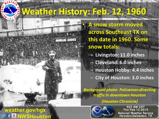
55 Years ago today a nice snowstorm impacted SE Texas and Houston. I recently received some old photos from my Mom of me playing in the snow during that event. I guess I need to scan them and share what a real snowstorm looked like in the Houston Area... :wink:


Image
0 likes   
Carla/Alicia/Jerry(In The Eye)/Michelle/Charley/Ivan/Dennis/Katrina/Rita/Wilma/Ike/Harvey

Member: National Weather Association
Wx Infinity Forums
http://wxinfinity.com/index.php

Facebook.com/WeatherInfinity
Twitter @WeatherInfinity

User avatar
TeamPlayersBlue
Category 5
Category 5
Posts: 3462
Joined: Tue Feb 02, 2010 1:44 am
Location: Denver/Applewood, CO

Re: Re:

#4371 Postby TeamPlayersBlue » Thu Feb 12, 2015 10:28 am

wxman57 wrote:
TeamPlayersBlue wrote:Also, serious question, when was the last time we had a good line of storms come through as a cold front comes in? Used to have them all the time, this year they are non existent. Maybe they will come back in the spring.


This has been a very unusual winter in that most of our cold fronts have been "back-door" fronts, slipping in from the NNE-NE with no deep return flow off the Gulf ahead of them. To generate return flow, we need a southern storm track that moves lows/trofs from west-to-east across Texas. Over the last 4-6 weeks, we've had a ridge (high pressure) over the Rockies and no southern storm track.


Very true. West to east track is crucial. Its been a few years since we have had that track. #NWFlow


Folks in SE Tx need that low pressure to slow down. Would hate to waste this cold air.
0 likes   
Personal Forecast Disclaimer:
The posts in this forum are NOT official forecast and should not be used as such. They are just the opinion of the poster and may or may not be backed by sound meteorological data. They are NOT endorsed by any professional institution or storm2k.org. For official information, please refer to the NHC and NWS products.

stormlover2013

Re: Texas Winter 2014-2015

#4372 Postby stormlover2013 » Thu Feb 12, 2015 10:42 am

Still 3 days out, I don't trust any model till Sunday atleast !!
0 likes   

User avatar
Ntxw
Storm2k Moderator
Storm2k Moderator
Posts: 22893
Joined: Wed Oct 21, 2009 6:34 pm
Location: DFW, Texas

#4373 Postby Ntxw » Thu Feb 12, 2015 10:44 am

The cold is coming, you best prepare for that. Especially if you were planning on winter being over like some of the plants. Storm well lots of details to work out there is room for either way. The models are not suggesting a change in the 500mb flow for sustained warmth thereafter as what was the GOA domain has been replaced by a ridge. They generally have a deep trof across the central CONUS. Unless you want to believe the surface depictions which I'm sure wxman57 does!
0 likes   
The above post and any post by Ntxw is NOT an official forecast and should not be used as such. It is just the opinion of the poster and may or may not be backed by sound meteorological data. It is NOT endorsed by any professional institution including Storm2k. For official information, please refer to NWS products.

  Help support Storm2K!
Help Support Storm2K

User avatar
Tireman4
S2K Supporter
S2K Supporter
Posts: 5858
Age: 60
Joined: Fri Jun 30, 2006 1:08 pm
Location: Humble, Texas
Contact:

Re:

#4374 Postby Tireman4 » Thu Feb 12, 2015 11:00 am

Ntxw wrote:The cold is coming, you best prepare for that. Especially if you were planning on winter being over like some of the plants. Storm well lots of details to work out there is room for either way. The models are not suggesting a change in the 500mb flow for sustained warmth thereafter as what was the GOA domain has been replaced by a ridge. They generally have a deep trof across the central CONUS. Unless you want to believe the surface depictions which I'm sure wxman57 does!


Agreed. For me, I will wait on the white stuff until 3 days out...cold..yes sir..:)
0 likes   

User avatar
srainhoutx
S2K Supporter
S2K Supporter
Posts: 6919
Age: 68
Joined: Sun Jan 14, 2007 11:34 am
Location: Haywood County, NC
Contact:

Re: Texas Winter 2014-2015

#4375 Postby srainhoutx » Thu Feb 12, 2015 11:34 am

The WPC Morning Update suggests early next week into Wednesday/Thursday may be very cold and unsettled. As the overnight ensembles suggested, the Western Upper Ridge looks to shift offshore of the West Coast allowing some very cold air to settle South across areas that have been very warm with near or record breaking warmth the past week. This very cold air is being pulled South into the Lower 48 due to a very strong upper low (Polar Vortex) developing across the Great Lakes into New England. The fly in the ointment will be what happens as the Upper Ridge builds North into Alaska producing a cross polar flow that sets up into the Great Basin/Inter Mountain West and the Great Plains on East. The ejection of Eastern Pacific moisture being pulled NE as a Upper Low near the Baja Peninsula begins its move E. What we do know today is that it is going to get cold and perhaps bring the coldest air of the Winter Season into our Region. What is not known is how quickly that Eastern Pacific moisture will arrive or how far South that moisture may spread E. As of today interest is growing that somewhere across our Region may experience winter precipitation in some form or fashion. If the cold shallow dense air travels South quickly as we typically experience, then attention turns to the potential for a bit more widespread Winter event that has the potential to extend well beyond our Region into the Eastern United States including the Northern Gulf Coast and the SE United States on up the Eastern Seaboard. There is a lot of potential for a major societal impact event beyond Texas and Louisiana, so it warrants our attention as the weekend nears and particularly early next week when the 'finer details' become a bit more certain. The 12Z GFS has a 1055+mb Arctic High dropping South out of Canada which is impressive by February standards.

EXTENDED FORECAST DISCUSSION
NWS WEATHER PREDICTION CENTER COLLEGE PARK MD
1042 AM EST THU FEB 12 2015

VALID 12Z SUN FEB 15 2015 - 12Z THU FEB 19 2015

...FRIGID ARCTIC BLASTS WITH STORMY WINTER WEATHER...

...GUIDANCE/UNCERTAINTY ASSESSMENT...

LATEST GUIDANCE CONTINUE TO OFFER BELOW NORMAL FORECAST SPREAD
INTO TUE/DAY 5. THIS LENDS PREFERENCE FOR A COMPOSITE BLEND OF
COMPATABLE 06 UTC GFS AND 00 UTC ECMWF/CANADIAN MODELS AS A
BASEMAP FOR WPC SURFACE FRONTS/PRESSURES AND 500 MB PROGS. THIS
BLEND OF DETERMINISTIC MODEL INPUT INCORPORATES MORE SMALLER SCALE
DETAIL THAN NORMAL AS CONSISTENT WITH PREDICTABILITY.

FORECAST SPREAD INCREASES ENOUGH INTO DAYS 6/7 TO INCREASE
UNCERTAINTY TO AT LEAST AVERAGE LEVELS SO BY THEN USED A MUCH MORE
ENSEMBLE MEAN BASED FORECAST APPROACH WITH A 30/70 MIX OF THE 00
UTC ECMWF/ECMWF ENSEMBLE MEAN. THESE REPRESENT SOLUTIONS ON THE
AMPLIFIED SIDE OF THE FULL ENVELOPE OF GUIDANCE. WATER VAPOR LOOPS
SHOW QUITE AN AMPLIFYING UPSTREAM RIDGE PATTERN ALONG/OFF THE NOAM
WEST COAST ALONG WITH POTENT/WELL SPACED ERN PACIFIC AND DATELINE
LOWS FEEDING INTO THAT RIDGE. THE ECMWF IS A STARK OUTLIER
AMPLIFIED SOLUTION THOUGH SO PREFER TO LIMIT INCLUSION GIVEN
UNCERTAINTY AT LONGER TIME FRAMES.

...PATTERN OVERVIEW AND SENSIBLE WEATHER HIGHLIGHTS...

A DANGEROUS AND HIGHLY AMPLIFIED NERN US/CANADIAN MARITIMES POLAR
VORTEX SUN-MON WILL USHER IN DEEP COLD AIR ACROSS THE CENTRAL AND
ERN US IN THE WAKE OF A DEEP NERN US COASTAL LOW AND TRAILING
FRONT. THIS OFFERS AN AMPLE STORM THREAT FOR NEW ENGLAND IN
PARTICULAR ALONG WITH A HUGE WIND/WAVE EVENT SPREAD WELL INTO THE
WRN ATLANTIC. THIS COLD ONSET AIR ALSO SETS THE STAGE FOR A LARGE
SCALE WINTER WEATHER THREAT EARLY-MID NEXT WEEK.

MEANWHILE...MODELS AND ENSEMBLES HAVE TRENDED/COME INTO BETTER
AGREEMENT TODAY IN SHOWING THE UPSTREAM WRN US RIDGE RETROGRESSION
AND STRONG AMPLIFICATION OFFSHORE AND UP TOWARD ALASKA INTO EARLY
NEXT WEEK IN RESPONSE TO UPSTREAM DEEP PACIFIC LOW DEVELOPMENTS.
THIS SHOULD ALLOW UNSETTLING TROUGH DIGGING ALOFT WITH LOWERING
HEIGHTS AND COOLING THROUGH THE WRN AND CENTRAL US INTO EARLY-MID
NEXT WEEK ALONG WITH A POTENT COLD SURFACE HIGH INFUSIONS. THIS
SUPPORTS AN EMERGING SW US AND S-CENTRAL GREAT BASIN/ROCKIES SNOW
THREAT AIDED BY TERRAIN/UPSLOPE FETCH.

WRN NOAM FLOW AMPLIFICATION ALSO LEADS TO AN INCREASINGLY
FAVORABLE GULF OF MEXICO MOISTURE/WAA RETURN FLOW PATTERN MON-WED
INTO/OVER AMBIENT AND SLOWLY RECEEDING LOWER LEVEL COLD AIR ACROSS
THE EAST-CENTRAL US DOWNSTREAM ALONG/AHEAD OF A WAVY COLD FRONT.
PENDING STREAM INTERACTION EFFECTS AND SWEATING THE IMPORTANT
SMALLER SCALE DETAILS...THIS OFFERS SOME PROLONGED HEAVIER PERIODS
OF SNOW AND DANGEROUS/TRANSITIONAL HEAVY ICING ACROSS A
POTENTIALLY LARGE THREAT AREA IN VICINITY FROM THE S-CENTRAL
PLAINS/MS VALLEY MON NEWD ACROSS THE E-CENTRAL US AND ERN/NERN US
ON THE NRN PERIPHERY OF THE EXPANDING OVERALL PCPN SHIELD. WPC
WEATHER/PCPN TYPE GRIDS OFFER A GRAPHICAL DEPICTION AND A MORE
AMPLIFIED DAY 6/7 WPC SCENARIO LEAVES THE DOOR MORE OPEN FOR
POSSIBLE TRAILING SURFACE FRONTAL WAVE DEVELOPMENTS THAT COULD ADD
CONVERGENCE/PCPN THREAT.

SCHICHTEL
0 likes   
Carla/Alicia/Jerry(In The Eye)/Michelle/Charley/Ivan/Dennis/Katrina/Rita/Wilma/Ike/Harvey

Member: National Weather Association
Wx Infinity Forums
http://wxinfinity.com/index.php

Facebook.com/WeatherInfinity
Twitter @WeatherInfinity

User avatar
TeamPlayersBlue
Category 5
Category 5
Posts: 3462
Joined: Tue Feb 02, 2010 1:44 am
Location: Denver/Applewood, CO

Re: Texas Winter 2014-2015

#4376 Postby TeamPlayersBlue » Thu Feb 12, 2015 11:51 am

stormlover2013 wrote:Still 3 days out, I don't trust any model till Sunday atleast !!


Positive look is that the ridge begins building in only a couple of days. That should meet your forecast timeline :)
0 likes   
Personal Forecast Disclaimer:
The posts in this forum are NOT official forecast and should not be used as such. They are just the opinion of the poster and may or may not be backed by sound meteorological data. They are NOT endorsed by any professional institution or storm2k.org. For official information, please refer to the NHC and NWS products.

User avatar
wxman57
Moderator-Pro Met
Moderator-Pro Met
Posts: 23074
Age: 68
Joined: Sat Jun 21, 2003 8:06 pm
Location: Houston, TX (southwest)

Re: Texas Winter 2014-2015

#4377 Postby wxman57 » Thu Feb 12, 2015 11:54 am

12Z GFS is losing the cold air. Now forecasting only 32-33 for the low in the D-FW area (and Houston) on Wednesday with highs near 50 (vs. 31 for 6Z GFS). Now 42 for Thursday's low (40 in Houston).
0 likes   

User avatar
Tireman4
S2K Supporter
S2K Supporter
Posts: 5858
Age: 60
Joined: Fri Jun 30, 2006 1:08 pm
Location: Humble, Texas
Contact:

Re: Texas Winter 2014-2015

#4378 Postby Tireman4 » Thu Feb 12, 2015 11:55 am

wxman57 wrote:12Z GFS is losing the cold air. Now forecasting only 32-33 for the low in the D-FW area (and Houston) on Wednesday with highs near 50 (vs. 31 for 6Z GFS). Now 42 for Thursday's low (40 in Houston).


Yes, but is that not typical of GFS. Losing the air (cold) 3-5 days out?
0 likes   

User avatar
CaptinCrunch
S2K Supporter
S2K Supporter
Posts: 8738
Age: 57
Joined: Mon Nov 03, 2003 4:33 pm
Location: Kennedale, TX (Tarrant Co.)

#4379 Postby CaptinCrunch » Thu Feb 12, 2015 11:57 am

We all knew this warm pattern wouldn't last, seen it before. when I was working as an A/C tech back in 96 I remember having to change out a compressor on an A/C unit cause the temp was 95 on February 21, by February 26th we had ice and snow on the ground, about 3" as I can remember. It stayed cold well into March, and even saw a freeze in early April.
0 likes   

User avatar
TeamPlayersBlue
Category 5
Category 5
Posts: 3462
Joined: Tue Feb 02, 2010 1:44 am
Location: Denver/Applewood, CO

Re: Texas Winter 2014-2015

#4380 Postby TeamPlayersBlue » Thu Feb 12, 2015 12:01 pm

wxman57 wrote:12Z GFS is losing the cold air. Now forecasting only 32-33 for the low in the D-FW area (and Houston) on Wednesday with highs near 50 (vs. 31 for 6Z GFS). Now 42 for Thursday's low (40 in Houston).


With that 500 MB chart, i have no idea how Houston wouldnt get into the 30's lol
0 likes   
Personal Forecast Disclaimer:
The posts in this forum are NOT official forecast and should not be used as such. They are just the opinion of the poster and may or may not be backed by sound meteorological data. They are NOT endorsed by any professional institution or storm2k.org. For official information, please refer to the NHC and NWS products.


Return to “Winter Weather”

Who is online

Users browsing this forum: No registered users and 117 guests