ATL: Tropical Depression Fay
Moderator: S2k Moderators


-
Dean4Storms
- S2K Supporter

- Posts: 6358
- Age: 63
- Joined: Sun Aug 31, 2003 1:01 pm
- Location: Miramar Bch. FL

Re: ATL: Tropical Storm Fay Pet and Wildlife Reactions
greels wrote:Artist,,,,,
Exactly! The reason why this was pointed out to us,in particular, is that we do not have the all the "tools " you folks have back in the States to give us the immediate weather data we might like to have...the majority of the population here does not have access to internet, much less some of them....televisions...so...when it's back to the very basics...."watch the animals" so to speak .....
greels, that makes sense. Sometimes I think we do need to listen to the old timers (of which I am becoming
0 likes
-
Dean4Storms
- S2K Supporter
- Posts: 6358
- Age: 63
- Joined: Sun Aug 31, 2003 1:01 pm
- Location: Miramar Bch. FL


-
dolebot_Broward_NW
- Category 2

- Posts: 529
- Joined: Fri Sep 10, 2004 6:38 am
Re: 92L Personal forecasts
The posts in this forum are NOT official forecast and should not be used as such. They are just the opinion of the poster and may or may not be backed by sound meteorological data. They are NOT endorsed by any professional institution or storm2k.org. For official information, please refer to the NHC and NWS products.
This is not a real forecast, I'm not a real forecaster, please disregard this and listen to official sources.
My terribly unprofessional and even more ridiculously uneducated guessticast for Fay follows:
24 Hours - We see Fay at 21n, 76w 45kts
48 Hours - 23n,78w 50kts
72 hours - 24.5n, 80.5w 70kts
0 likes

-
BensonTCwatcher

- Category 5

- Posts: 1050
- Joined: Sat Aug 28, 2004 10:11 pm
- Location: Southport NC

-
Tampa Bay Hurricane

- Category 5
- Posts: 5597
- Age: 38
- Joined: Fri Jul 22, 2005 7:54 pm
- Location: St. Petersburg, FL

Re: ATL: Tropical Storm Fay
baynews9 met mike clay said don't let our guard down and dismiss this. That isn't his style as far as hype so he is serious. He agrees nothing is written in stone but warnings could go up as soon as sunday night. If it crosses cuba it could get ripped apart if it goes south in the open waters then watch out and eventhough it's currently progged to be a ts we cant rule out this becoming a hurricane. so keep an eye and prepare.
0 likes
-
SouthFLTropics

- Category 5
- Posts: 4258
- Age: 50
- Joined: Thu Aug 14, 2003 8:04 am
- Location: Port St. Lucie, Florida
Re:
Tampa Bay Hurricane wrote:That would bring 80 mph winds with gusts to 100 mph
up the west coast. The east coast, Keys, Miami would
see 60 mph winds gusts to 80 mph on that path of
Accuweather.
Based on that track the Keys would get more than 60mph winds. They would take a direct hit...Let's hope the intensity forecasts are wrong and that this girl won't decide to get cranky when she gets her feet wet again.
Edit: I see you edited your post
SFT
Last edited by SouthFLTropics on Fri Aug 15, 2008 6:02 pm, edited 1 time in total.
0 likes
-
storms in NC

- S2K Supporter
- Posts: 2338
- Joined: Thu Jul 28, 2005 2:58 pm
- Location: Wallace,NC 40 miles NE of Wilm
- Contact:
The stronger she get the more to the north she will go? Is that right? And by the looks right now not going to be weak long. But then again there was Dean and went west
Last edited by storms in NC on Fri Aug 15, 2008 6:03 pm, edited 1 time in total.
0 likes
-
Rainband
-
Tampa Bay Hurricane
- Category 5
- Posts: 5597
- Age: 38
- Joined: Fri Jul 22, 2005 7:54 pm
- Location: St. Petersburg, FL
-
Pearl River

- S2K Supporter
- Posts: 825
- Age: 67
- Joined: Fri Dec 09, 2005 6:07 pm
- Location: SELa
Re: ATL: Tropical Storm Fay
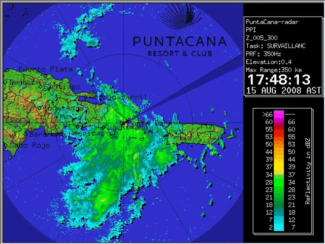
http://www.insmet.cu/asp/genesis.asp?TB0=PLANTILLAS&TB1=RADARES
I think this is as close as you will get to radar from Haiti.
I think this is as close as you will get to radar from Haiti.
Last edited by Pearl River on Fri Aug 15, 2008 6:07 pm, edited 1 time in total.
0 likes
-
Matt-hurricanewatcher
Re: ATL: Tropical Storm Fay
4pm pst/7pm est
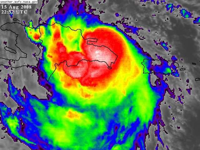
My center est is near the black spot near 18.5/69.2 moving westward. This is based on surface obs and satellite.
Next update from me in 2 hours. In off topic news it is 100 degree's at my house. WOW hot!
My center est is near the black spot near 18.5/69.2 moving westward. This is based on surface obs and satellite.
Next update from me in 2 hours. In off topic news it is 100 degree's at my house. WOW hot!
0 likes
Who is online
Users browsing this forum: No registered users and 189 guests