

As NDG has mentioned, ridging to the north of Dorian has been underestimated by both the GFS and the EURO in the short term. My phone won’t let me upload trend GIFs but just toggle 500mb height anomalies for the 00z euro vs. 24 hours ago and the 00z GFS and the 06z GFS vs. their estimates from 6 hours before. Note the increase in heights in the southeast and off the coast. This will probably aid in slightly more westward motion than some suites are forecasting in the next 60 hours.
Models agree that the shortwave passing over the eastern US on Monday should lower heights ahead of it and beneath it, leading to Dorian’s stall and drift NNW before a second shortwave on Wednesday pulls the storm ENE. South trends in the short term are awful for the Bahamas but may actually help avoid a US landfall, because the ENE movement would occur further south of the Carolinas. However, this hinges on the strength / amplitude of these troughs, as weaker troughing would allow Dorian to drift further west towards FL / the Southeast before a route to recurve opens up. Not to mention the strength / orientation of the ridging east / SE of Dorian which will be modified by Dorian’s own outflow. Sheesh, plenty to watch over the next 5 days.
ATL: DORIAN - Models
Moderator: S2k Moderators
Re: ATL: DORIAN - Models
Last edited by Siker on Sat Aug 31, 2019 9:27 am, edited 1 time in total.
6 likes

Re: ATL: DORIAN - Models
USTropics wrote:06z UKMET ensembles haven't changed:
https://i.imgur.com/NTwABVo.png
OK, went from 1 into Louisiana to 2.
0 likes
Personal Forecast Disclaimer:
The posts in this forum are NOT official forecast and should not be used as such. They are just the opinion of the poster and may or may not be backed by sound meteorological data. They are NOT endorsed by any professional institution or storm2k.org. For official information, please refer to the NHC and NWS products.
The posts in this forum are NOT official forecast and should not be used as such. They are just the opinion of the poster and may or may not be backed by sound meteorological data. They are NOT endorsed by any professional institution or storm2k.org. For official information, please refer to the NHC and NWS products.
Re: ATL: DORIAN - Models
USTropics wrote:06z UKMET ensembles haven't changed:
https://i.imgur.com/NTwABVo.png
What is the green one that hits PBC east to west..is that the ensemble mean?
0 likes
-
USTropics
- Professional-Met

- Posts: 2738
- Joined: Sun Aug 12, 2007 3:45 am
- Location: Florida State University
Re: ATL: DORIAN - Models
caneseddy wrote:USTropics wrote:06z UKMET ensembles haven't changed:
https://i.imgur.com/NTwABVo.png
What is the green one that hits PBC east to west..is that the ensemble mean?
That is the mean of all ensemble members.
1 likes
-
AutoPenalti
- Category 5

- Posts: 4091
- Age: 29
- Joined: Mon Aug 17, 2015 4:16 pm
- Location: Ft. Lauderdale, Florida
Re: ATL: DORIAN - Models
Is that the new UKMET? I thought the operational was right of the ensemble mean.
0 likes
The posts in this forum are NOT official forecasts and should not be used as such. They are just the opinion of the poster and may or may not be backed by sound meteorological data. They are NOT endorsed by any professional institution or STORM2K. For official information, please refer to products from the NHC and NWS.
Model Runs Cheat Sheet:
GFS (5:30 AM/PM, 11:30 AM/PM)
HWRF, GFDL, UKMET, NAVGEM (6:30-8:00 AM/PM, 12:30-2:00 AM/PM)
ECMWF (1:45 AM/PM)
TCVN is a weighted averaged

Re: ATL: DORIAN - Models
USTropics wrote:06z UKMET ensembles haven't changed:
https://i.imgur.com/NTwABVo.png
Forgive my ignorance but why does the UKM model take it off the coast if most of it's ensemble members have it hitting Florida directly?
0 likes
-
USTropics
- Professional-Met
- Posts: 2738
- Joined: Sun Aug 12, 2007 3:45 am
- Location: Florida State University
Re: ATL: DORIAN - Models
jfk08c wrote:USTropics wrote:06z UKMET ensembles haven't changed:
https://i.imgur.com/NTwABVo.png
Forgive my ignorance but why does the UKM model take it off the coast if most of it's ensemble members have it hitting Florida directly?
Ensemble members are given different starting variables, to give an idea if x trough is weaker/stronger and y ridge is weaker/stronger, what are the possible outcomes?
2 likes
-
chris_fit

- Category 5
- Posts: 3261
- Age: 43
- Joined: Wed Sep 10, 2003 11:58 pm
- Location: Tampa Bay Area, FL
Re: ATL: DORIAN - Models
USTropics wrote:06z UKMET ensembles haven't changed:
https://i.imgur.com/NTwABVo.png
I'd say that it did change, leaning more left than at the 00Z
1 likes
-
USTropics
- Professional-Met
- Posts: 2738
- Joined: Sun Aug 12, 2007 3:45 am
- Location: Florida State University
Re: ATL: DORIAN - Models
AutoPenalti wrote:Is that the new UKMET? I thought the operational was right of the ensemble mean.
06z/18z UKMET operational is run out to 60 hours only, the ensembles are run out to 168 hours though. You can find them here when they update:
https://ruc.noaa.gov/hfip/tceps/tceps.php?model=ncep
1 likes
-
USTropics
- Professional-Met
- Posts: 2738
- Joined: Sun Aug 12, 2007 3:45 am
- Location: Florida State University
Re: ATL: DORIAN - Models
chris_fit wrote:USTropics wrote:06z UKMET ensembles haven't changed:
https://i.imgur.com/NTwABVo.png
I'd say that it did change, leaning more left than at the 00Z
Let me rephrase, the mean of the ensemble members hasn't changed from the 00z run:

1 likes
-
Aric Dunn
- Category 5
- Posts: 21238
- Age: 43
- Joined: Sun Sep 19, 2004 9:58 pm
- Location: Ready for the Chase.
- Contact:
Re: ATL: DORIAN - Models
USTropics wrote:chris_fit wrote:USTropics wrote:06z UKMET ensembles haven't changed:
https://i.imgur.com/NTwABVo.png
I'd say that it did change, leaning more left than at the 00Z
Let me rephrase, the mean of the ensemble members hasn't changed from the 00z run:
https://i.imgur.com/90VpT8m.gif
not much change slightly left..
but some of the members are very intereting.
0 likes
Note: If I make a post that is brief. Please refer back to previous posts for the analysis or reasoning. I do not re-write/qoute what my initial post said each time.
If there is nothing before... then just ask
Space & Atmospheric Physicist, Embry-Riddle Aeronautical University,
I believe the sky is falling...
If there is nothing before... then just ask
Space & Atmospheric Physicist, Embry-Riddle Aeronautical University,
I believe the sky is falling...
-
stormlover2013
-
gatorcane

- S2K Supporter

- Posts: 23708
- Age: 48
- Joined: Sun Mar 13, 2005 3:54 pm
- Location: Boca Raton, FL
Re: ATL: DORIAN - Models
06Z EPS

More ensembles into SE Florida than 00Z. We are not off the hook in South Florida. And those UKMET ensembles are mostly into SE Florida. See graphic further up.
More ensembles into SE Florida than 00Z. We are not off the hook in South Florida. And those UKMET ensembles are mostly into SE Florida. See graphic further up.
1 likes
-
HurricaneFrances04
- Category 2

- Posts: 597
- Joined: Mon Jun 25, 2012 8:09 am
- Location: Fort Lauderdale, Florida
Re: ATL: DORIAN - Models
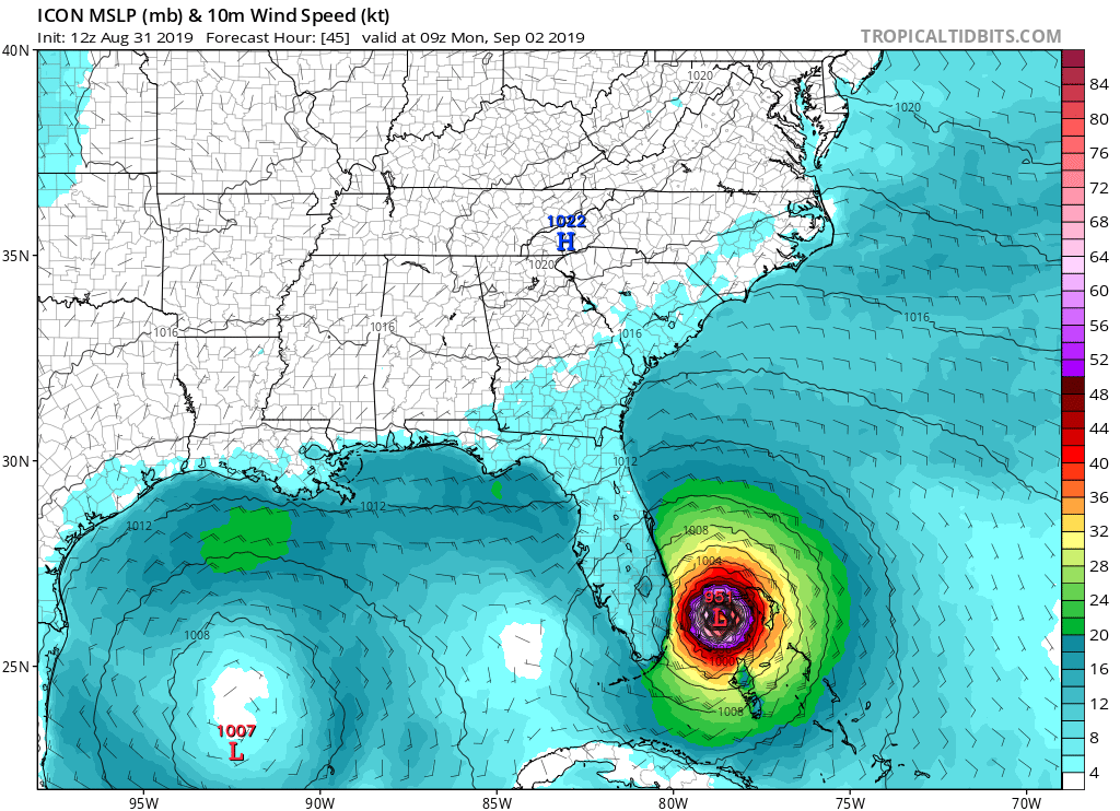
12Z ICON is south of the 6Z. Pretty much due west through 24 hours.
0 likes

Re: ATL: DORIAN - Models
I counted only 2 out 51 ECM ensemble members hitting Florida on the 00z run versus about 14 or so on the 06z run. Also the overall orientation of the tracks are definitely more northerly on 00z versus more N-NW on most recent run. It may not mean much yet, but the 06z UK ensemble mean shifted slightly south at landfall and west closer to Tampa. So while overall offshore tracks look good at the moment, we need to closely monitor the situation over the next few days.
0 likes
-
gatorcane
- S2K Supporter
- Posts: 23708
- Age: 48
- Joined: Sun Mar 13, 2005 3:54 pm
- Location: Boca Raton, FL
Re: ATL: DORIAN - Models
HurricaneFrances04 wrote:12Z ICON is south of the 6Z. Pretty much due west through 24 hours.
Heading west:
0 likes
-
AutoPenalti
- Category 5
- Posts: 4091
- Age: 29
- Joined: Mon Aug 17, 2015 4:16 pm
- Location: Ft. Lauderdale, Florida
Re: ATL: DORIAN - Models
Oh boy here we go...
0 likes
The posts in this forum are NOT official forecasts and should not be used as such. They are just the opinion of the poster and may or may not be backed by sound meteorological data. They are NOT endorsed by any professional institution or STORM2K. For official information, please refer to products from the NHC and NWS.
Model Runs Cheat Sheet:
GFS (5:30 AM/PM, 11:30 AM/PM)
HWRF, GFDL, UKMET, NAVGEM (6:30-8:00 AM/PM, 12:30-2:00 AM/PM)
ECMWF (1:45 AM/PM)
TCVN is a weighted averaged
Re: ATL: DORIAN - Models
gatorcane wrote:HurricaneFrances04 wrote:12Z ICON is south of the 6Z. Pretty much due west through 24 hours.
Heading west:
https://i.postimg.cc/9Ftfx3mc/icon-mslp-wind-seus-16.png
And this could be the next 24 hours of models where everything starts moving a little more West. Just like yesterday was a move East.
2 likes
Personal Forecast Disclaimer:
The posts in this forum are NOT official forecast and should not be used as such. They are just the opinion of the poster and may or may not be backed by sound meteorological data. They are NOT endorsed by any professional institution or storm2k.org. For official information, please refer to the NHC and NWS products.
The posts in this forum are NOT official forecast and should not be used as such. They are just the opinion of the poster and may or may not be backed by sound meteorological data. They are NOT endorsed by any professional institution or storm2k.org. For official information, please refer to the NHC and NWS products.

Re: ATL: DORIAN - Models
Keeping a close eye on that 26N 74W mark. It is foretasted to pass north of that.
1 likes
Who is online
Users browsing this forum: No registered users and 32 guests