ATL: Ex-Tropical Storm FIONA - Discussion
Moderator: S2k Moderators


Re: ATL: INVEST 97L - Discussion
90 percent is bold, especially given the relative lack of deep convection...but I reckon it has to develop sooner or later. FWIW, it's about the same distance, maybe a bit farther, than Fran was from Edouard in 1996
0 likes
-
ConvergenceZone
.gif)
- Category 5

- Posts: 5241
- Joined: Fri Jul 29, 2005 1:40 am
- Location: Northern California
-
dexterlabio
- Category 5
- Posts: 3511
- Joined: Sat Oct 24, 2009 11:50 pm
Re: ATL: INVEST 97L - Discussion
ECMWF shows a recurve for Fiona. At least the tension lies bit low for now. 
0 likes
Personal Forecast Disclaimer:
The posts in this forum are NOT official forecast and should not be used as such. They are just the opinion of the poster and may or may not be backed by sound meteorological data. They are NOT endorsed by any professional institution or storm2k.org. For official information, please refer to the NHC and NWS products.
The posts in this forum are NOT official forecast and should not be used as such. They are just the opinion of the poster and may or may not be backed by sound meteorological data. They are NOT endorsed by any professional institution or storm2k.org. For official information, please refer to the NHC and NWS products.
-
Brent
- S2K Supporter

- Posts: 38765
- Age: 37
- Joined: Sun May 16, 2004 10:30 pm
- Location: Tulsa Oklahoma
- Contact:
Re:
ConvergenceZone wrote:Looks like we might get a well deserved break after Fiona...The tropics have really been busy the last couple of weeks. Once Fiona develops, it might be two week lull or so before it picks back up later in September...
I'd be very surprised if we had a lull at peak season.
0 likes
#neversummer

Re: ATL: INVEST 97L - Discussion
Brent wrote:SHOWER AND THUNDERSTORM ACTIVITY HAS BECOME A LITTLE MORE
CONCENTRATED NEAR THE CENTER OF A LOW PRESSURE SYSTEM LOCATED ABOUT
1150 MILES EAST OF THE LESSER ANTILLES. UPPER-LEVEL WINDS ARE
CONDUCIVE FOR DEVELOPMENT...AND A TROPICAL DEPRESSION COULD FORM AT
ANY TIME DURING THE NEXT DAY OR TWO. THERE IS A HIGH CHANCE...90
PERCENT...OF THIS SYSTEM BECOMING A TROPICAL CYCLONE DURING THE
NEXT 48 HOURS AS IT MOVES GENERALLY WESTWARD AT ABOUT 20 MPH.
I don't know why they would rise it to 90% when it still looks like that...sparse convection. They didn't decrease it when it looked horrible from Saturday but when there is a small puff of moderate convection it goes to 90%??
0 likes
-
ConvergenceZone
- Category 5
- Posts: 5241
- Joined: Fri Jul 29, 2005 1:40 am
- Location: Northern California
Re: Re:
Brent wrote:ConvergenceZone wrote:Looks like we might get a well deserved break after Fiona...The tropics have really been busy the last couple of weeks. Once Fiona develops, it might be two week lull or so before it picks back up later in September...
I'd be very surprised if we had a lull at peak season.
I'm just basing that entirely on the Models Brent....
0 likes
Re: Re:
Brent wrote:ConvergenceZone wrote:Looks like we might get a well deserved break after Fiona...The tropics have really been busy the last couple of weeks. Once Fiona develops, it might be two week lull or so before it picks back up later in September...
I'd be very surprised if we had a lull at peak season.
If that happened it wouldn't be much of a hurricane season. To meet expectations from before this season started, this September will have to be the busiest on record with very active months afterwards.
0 likes
Navy keeps issuing TCFAs. Latest one below.
WTNT21 KNGU 300000
MSGID/GENADMIN/NAVMARFCSTCEN NORFOLK VA//
SUBJ/TROPICAL CYCLONE FORMATION ALERT//
RMKS/1. FORMATION OF A TROPICAL CYCLONE IS POSSIBLE WITHIN 100 NM
EITHER SIDE OF A LINE FROM 13.4N 38.5W TO 14.4N 46.0W OVER THE
NEXT 24 HOURS. AVAILABLE DATA DOES NOT JUSTIFY THE ISSUANCE OF A NUMBERED
TROPICAL CYCLONE WARNING AT THIS TIME.
2. REMARKS: AN ASCAT PASS AT 1229 ZULU SHOWS A SURFACE CIRCULATION
CENTERED AT 13.8N 32.6W. MODELS SHOW THIS SYSTEM AS BECOMING BETTER
ORGANIZED AS IT MOVES WEST-NORTHWEST UNDER AN AREA OF WEAK WIND SHEAR.
THIS, IN CONJUNCTION WITH A WEAK UPPER LEVEL ANTICYCLONE AND WARM SEA
SURFACE TEMPERATURES OF 83 TO 85 DEGREES FAHRENHEIT SHOULD HELP TO
ENHANCE THE DEVELOPMENT OF THIS TROPICAL FEATURE.
3. THIS ALERT WILL BE REISSUED, UPGRADED TO A WARNING OR ALLOWED TO
EXPIRE BY 310000Z.//

Latest microwave:

WTNT21 KNGU 300000
MSGID/GENADMIN/NAVMARFCSTCEN NORFOLK VA//
SUBJ/TROPICAL CYCLONE FORMATION ALERT//
RMKS/1. FORMATION OF A TROPICAL CYCLONE IS POSSIBLE WITHIN 100 NM
EITHER SIDE OF A LINE FROM 13.4N 38.5W TO 14.4N 46.0W OVER THE
NEXT 24 HOURS. AVAILABLE DATA DOES NOT JUSTIFY THE ISSUANCE OF A NUMBERED
TROPICAL CYCLONE WARNING AT THIS TIME.
2. REMARKS: AN ASCAT PASS AT 1229 ZULU SHOWS A SURFACE CIRCULATION
CENTERED AT 13.8N 32.6W. MODELS SHOW THIS SYSTEM AS BECOMING BETTER
ORGANIZED AS IT MOVES WEST-NORTHWEST UNDER AN AREA OF WEAK WIND SHEAR.
THIS, IN CONJUNCTION WITH A WEAK UPPER LEVEL ANTICYCLONE AND WARM SEA
SURFACE TEMPERATURES OF 83 TO 85 DEGREES FAHRENHEIT SHOULD HELP TO
ENHANCE THE DEVELOPMENT OF THIS TROPICAL FEATURE.
3. THIS ALERT WILL BE REISSUED, UPGRADED TO A WARNING OR ALLOWED TO
EXPIRE BY 310000Z.//
Latest microwave:
0 likes
-
jlauderdal
- S2K Supporter
- Posts: 7240
- Joined: Wed May 19, 2004 5:46 am
- Location: NE Fort Lauderdale
- Contact:
Re: ATL: INVEST 97L - Discussion
Cyclenall wrote:Brent wrote:SHOWER AND THUNDERSTORM ACTIVITY HAS BECOME A LITTLE MORE
CONCENTRATED NEAR THE CENTER OF A LOW PRESSURE SYSTEM LOCATED ABOUT
1150 MILES EAST OF THE LESSER ANTILLES. UPPER-LEVEL WINDS ARE
CONDUCIVE FOR DEVELOPMENT...AND A TROPICAL DEPRESSION COULD FORM AT
ANY TIME DURING THE NEXT DAY OR TWO. THERE IS A HIGH CHANCE...90
PERCENT...OF THIS SYSTEM BECOMING A TROPICAL CYCLONE DURING THE
NEXT 48 HOURS AS IT MOVES GENERALLY WESTWARD AT ABOUT 20 MPH.
I don't know why they would rise it to 90% when it still looks like that...sparse convection. They didn't decrease it when it looked horrible from Saturday but when there is a small puff of moderate convection it goes to 90%??
they base their percentage on what they think could happen in the next 48 hrs, not how it looks initially although that goes into their overall reasoning of the forecast, in this case they may see the convection and say ok we have convection and based on that its worth raising another 10%. Also, forecasters are human and at the end of the day different forecasters interpret the parameters differently, they are dealing with a large menu of parameters and assigning a percentage, that formula is ripe for a difference of opinion.
0 likes
-
ColinDelia

- S2K Supporter
- Posts: 918
- Joined: Mon Aug 29, 2005 5:52 am
- Location: The Beach, FL
Has a lot going for it today.
Moving into waters with higher oceanic heat content

The SAL is much weaker to the west of the storm than the east

The convective potential has been increasing and is forecast to increase steadily throughout the day today
CAPE at 0z

Forecast CAPE at 6z
http://www.atmos.albany.edu/student/jan ... lot_42.gif
Forecast CAPE at 12z
http://www.atmos.albany.edu/student/jan ... lot_43.gif
Forecast CAPE at 18z
http://www.atmos.albany.edu/student/jan ... lot_44.gif
Moving into waters with higher oceanic heat content
The SAL is much weaker to the west of the storm than the east
The convective potential has been increasing and is forecast to increase steadily throughout the day today
CAPE at 0z
Forecast CAPE at 6z
http://www.atmos.albany.edu/student/jan ... lot_42.gif
Forecast CAPE at 12z
http://www.atmos.albany.edu/student/jan ... lot_43.gif
Forecast CAPE at 18z
http://www.atmos.albany.edu/student/jan ... lot_44.gif
0 likes
-
ColinDelia
- S2K Supporter
- Posts: 918
- Joined: Mon Aug 29, 2005 5:52 am
- Location: The Beach, FL
Ships only takes this to 52 knots now - predicting considerable shear in a few days.
TIME (HR) 0 6 12 18 24 36 48 60 72 84 96 108 120
V (KT) NO LAND 25 26 28 29 32 38 45 50 52 52 50 49 47
V (KT) LAND 25 26 28 29 32 38 45 50 52 52 50 49 47
V (KT) LGE mod 25 26 27 29 31 35 40 44 49 51 50 47 43
SHEAR (KT) 2 1 1 4 5 10 18 21 27 28 36 33 24
This assumes the BAMM track.
TIME (HR) 0 6 12 18 24 36 48 60 72 84 96 108 120
V (KT) NO LAND 25 26 28 29 32 38 45 50 52 52 50 49 47
V (KT) LAND 25 26 28 29 32 38 45 50 52 52 50 49 47
V (KT) LGE mod 25 26 27 29 31 35 40 44 49 51 50 47 43
SHEAR (KT) 2 1 1 4 5 10 18 21 27 28 36 33 24
This assumes the BAMM track.
0 likes
-
SootyTern
- S2K Supporter
- Posts: 316
- Age: 57
- Joined: Sun Sep 05, 2004 5:09 pm
- Location: NYC (formerly Homestead, FL)
Re:
Steve wrote:>>Steve nice interpretation of the models from prior runs....I do think its a valid point as to a more westward solution given the lack of organization....
Thanks ROCK. Generally I would agree. It's just that the 12z's didn't like our general point that weaker systems would tend to go west. European was farthest east through 72 and 96 hours but it was stronger than GEM or GFS. After 120, ECMWF was the strongest and farthest west. CMC was the second strongest and was still west of GFS. GFS was the weakest and the most east at that point and getting ready to recurve. So the weakest model ends up staying farthest east while two stronger models respectively ended up more westerly (SC/NC for GEM, LA for ECMWF). We have it down from earlier today, so we can re-visit on Wed. and Thursday to see which of these three had the best handle and where they were going with it.
Steve you think the difference in strength is causing the storm to be either further east or west or does the different position cause the difference in strength (ie better conditions for a fast west track?)
Also the track for 97L seems to be south of Dani/Earl so upwelling shouldn't be what is keeping it in check for now.
0 likes
-
WeatherGuesser
- Category 5
- Posts: 2672
- Joined: Tue Jun 29, 2010 6:46 am
-
ColinDelia
- S2K Supporter
- Posts: 918
- Joined: Mon Aug 29, 2005 5:52 am
- Location: The Beach, FL


Re:
ConvergenceZone wrote:Looks like we might get a well deserved break after Fiona...The tropics have really been busy the last couple of weeks. Once Fiona develops, it might be two week lull or so before it picks back up later in September...
you've been saying this for weeks.
0 likes


Re: ATL: INVEST 97L - Discussion
Core looks good.
However, MIMIC-TPW seems to show a possible boundary-layer dry-air entrainment in the near future.
As long as mid-level moisture is high and it runs into high CAPE / LI air, it should be able to eventually shake it off.
Also, convection is deep and there is enough stratiform precep being generated that is should survive the run thru dry-air.
Given the fact it needs to fight off some short term dry air, spin-up may be a little later in coming.
This may be significant in terms of forecast track.
A weaker system would steer it more westerly.
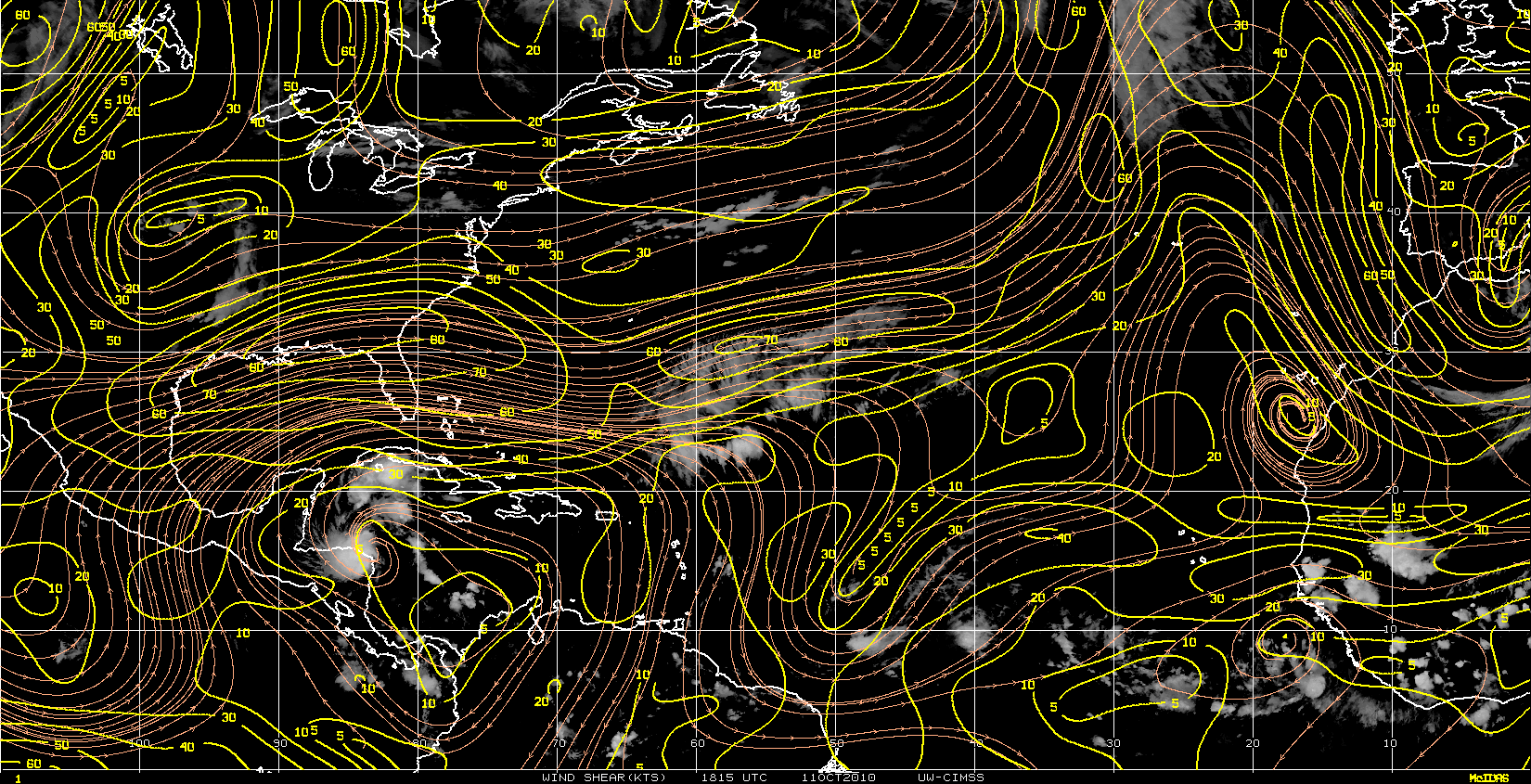
The anti-cyclone overhead is keeping it nicely protected from shear.
http://cimss.ssec.wisc.edu/tropic/real- ... t72hrs.gif


However, MIMIC-TPW seems to show a possible boundary-layer dry-air entrainment in the near future.
As long as mid-level moisture is high and it runs into high CAPE / LI air, it should be able to eventually shake it off.
Also, convection is deep and there is enough stratiform precep being generated that is should survive the run thru dry-air.
Given the fact it needs to fight off some short term dry air, spin-up may be a little later in coming.
This may be significant in terms of forecast track.
A weaker system would steer it more westerly.
The anti-cyclone overhead is keeping it nicely protected from shear.
http://cimss.ssec.wisc.edu/tropic/real- ... t72hrs.gif
0 likes
8AM TWO:
1. SHOWERS AND THUNDERSTORMS ARE GRADUALLY BECOMING BETTER ORGANIZED IN
ASSOCIATION WITH A LOW PRESSURE SYSTEM LOCATED ABOUT 1050 MILES
EAST OF THE LESSER ANTILLES. IF THIS TREND CONTINUES...A TROPICAL
DEPRESSION COULD FORM LATER TODAY OR TONIGHT AS THIS SYSTEM MOVES
GENERALLY WESTWARD AT ABOUT 20 MPH. THERE IS A HIGH CHANCE...90
PERCENT...OF THIS SYSTEM BECOMING A TROPICAL CYCLONE DURING THE
NEXT 48 HOURS.
0 likes


Who is online
Users browsing this forum: No registered users and 17 guests