ATL: ISAIAS - Models

Moderator: S2k Moderators

Message
Author
sma10
Category 5
Category 5
Posts: 1710
Joined: Tue Aug 02, 2005 1:13 pm

Re: ATL: INVEST 92L - Models

#461 Postby sma10 » Sun Jul 26, 2020 5:51 pm

SFLcane wrote:
cycloneye wrote:
SFLcane wrote::eek: 950’s

https://iili.io/dTsjwb.gif


Hi Adrian. Do you have the link to this experimental model?


Hi my friend sure do. I am following this model since it did so well last season. It has a major hurricane 950’s just of FL coastline. We shall see.

https://storm.aoml.noaa.gov/basin/?projectName=BASIN


Thanks for the link. Do we know when this will go "live"? Do we know if it has performed better than the HWRF this season?
0 likes   

User avatar
TheProfessor
Professional-Met
Professional-Met
Posts: 3506
Age: 28
Joined: Tue Dec 03, 2013 10:56 am
Location: Wichita, Kansas

Re: ATL: INVEST 92L - Models

#462 Postby TheProfessor » Sun Jul 26, 2020 5:58 pm

It's not a matter of models having trouble with storms that haven't consolidated and formed a LLC, it's more of the fact that before an LLC forms the models are estimating the location of where the LLC will form and since that's a forecast, it can have error. It's especially true with these large circulations. If the models are 50 miles off of where the center actually forms that could be the difference between a re-curve and a storm hitting the northern gulf down the road. That's why it's important to have the center nailed first. I've seen models have great consensus in the long range only for variability to increase in the medium range because something in the short term changed. Obviously if the models do nail where the actual center forms and most of them are correct with 92L becoming a hurricane then they can and most likely will be correct from this far out, but we've seen enough missteps only 2-3 days out with the models this year to be cautious about consensus that's 7-10 days away.
17 likes   
An alumnus of The Ohio State University.

Your local National Weather Service office is your best source for weather information.

User avatar
aspen
Category 5
Category 5
Posts: 8818
Joined: Sat Oct 12, 2019 7:10 pm
Location: Connecticut, USA

Re: ATL: INVEST 92L - Models

#463 Postby aspen » Sun Jul 26, 2020 6:20 pm

18z GFS is still weak. My best guess is that dry air gets into the broad circulation. It and 12z CMC and 18z ICON show a moderate TS in 4-5 days passing just north of Barbuda.
0 likes   
Irene '11 Sandy '12 Hermine '16 5/15/2018 Derecho Fay '20 Isaias '20 Elsa '21 Henri '21 Ida '21

I am only a meteorology enthusiast who knows a decent amount about tropical cyclones. Look to the professional mets, the NHC, or your local weather office for the best information.

supercane4867
Category 5
Category 5
Posts: 4966
Joined: Wed Nov 14, 2012 10:43 am

Re: ATL: INVEST 92L - Models

#464 Postby supercane4867 » Sun Jul 26, 2020 6:37 pm

18z HMON makes more sense than HWRF in terms of intensity and structure. Very broad and loose TS with low central pressure.

Image
0 likes   

HurricaneFrances04
Category 2
Category 2
Posts: 597
Joined: Mon Jun 25, 2012 8:09 am
Location: Fort Lauderdale, Florida

Re: ATL: INVEST 92L - Models

#465 Postby HurricaneFrances04 » Sun Jul 26, 2020 6:46 pm

Image
0 likes   

User avatar
SFLcane
S2K Supporter
S2K Supporter
Posts: 10163
Age: 47
Joined: Sat Jun 05, 2010 1:44 pm
Location: Lake Worth Florida

Re: ATL: INVEST 92L - Models

#466 Postby SFLcane » Sun Jul 26, 2020 6:47 pm

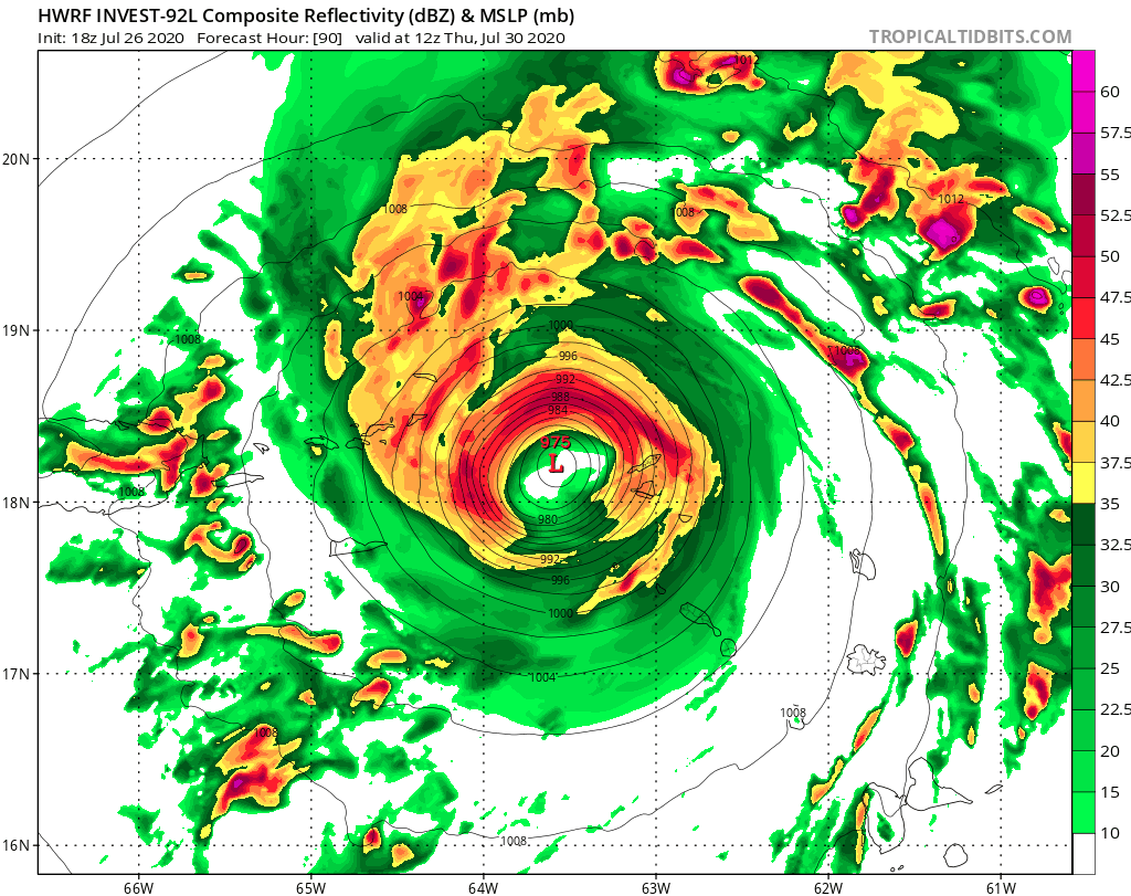
Luis, HWRF has a hurricane coming for you heading westward :eek:

Image
1 likes   

User avatar
Evil Jeremy
S2K Supporter
S2K Supporter
Posts: 5463
Age: 32
Joined: Mon Apr 10, 2006 2:10 pm
Location: Los Angeles, CA

Re: ATL: INVEST 92L - Models

#467 Postby Evil Jeremy » Sun Jul 26, 2020 7:01 pm

HurricaneFrances04 wrote:https://i.imgur.com/CR1LRXU.png


Here are Irma GFS ensembles from when Irma (a Cat 2 at this point, far more established for a model to latch on to, than an invest) was at 92L's longitude.

Image

Long. Week. Ahead.
12 likes   
Frances 04 / Jeanne 04 / Katrina 05 / Wilma 05 / Fay 08 / Debby 12 / Andrea 13 / Colin 16 / Hermine 16 / Matthew 16 / Irma 17

User avatar
SFLcane
S2K Supporter
S2K Supporter
Posts: 10163
Age: 47
Joined: Sat Jun 05, 2010 1:44 pm
Location: Lake Worth Florida

Re: ATL: INVEST 92L - Models

#468 Postby SFLcane » Sun Jul 26, 2020 7:02 pm

Evil Jeremy wrote:
HurricaneFrances04 wrote:https://i.imgur.com/CR1LRXU.png


Here are Irma GFS ensembles from when Irma (a Cat 2 at this point, far more established for a model to latch on to, than an invest) was at 92L's longitude.

https://pbs.twimg.com/media/DIp94JiVYAEzYOD?format=jpg

Long. Week. Ahead.


Sure thing..thank you for this.
2 likes   

User avatar
Blown Away
S2K Supporter
S2K Supporter
Posts: 10145
Joined: Wed May 26, 2004 6:17 am

Re: ATL: INVEST 92L - Models

#469 Postby Blown Away » Sun Jul 26, 2020 7:12 pm

SFLcane wrote:
Evil Jeremy wrote:
HurricaneFrances04 wrote:https://i.imgur.com/CR1LRXU.png


Here are Irma GFS ensembles from when Irma (a Cat 2 at this point, far more established for a model to latch on to, than an invest) was at 92L's longitude.

https://pbs.twimg.com/media/DIp94JiVYAEzYOD?format=jpg

Long. Week. Ahead.


Sure thing..thank you for this.


Honestly, I think every CV storm that has impacted the Caribbean and CONUS had a few model cycles of recurves.
4 likes   
Hurricane Eye Experience: David 79, Irene 99, Frances 04, Jeanne 04, Wilma 05... EYE COMING MY WAY IN 2024…
Hurricane Brush Experience: Andrew 92, Erin 95, Floyd 99, Matthew 16, Irma 17, Ian 22, Nicole 22…

AutoPenalti
Category 5
Category 5
Posts: 4030
Age: 29
Joined: Mon Aug 17, 2015 4:16 pm
Location: Ft. Lauderdale, Florida

Re: ATL: INVEST 92L - Models

#470 Postby AutoPenalti » Sun Jul 26, 2020 7:12 pm

Evil Jeremy wrote:
HurricaneFrances04 wrote:https://i.imgur.com/CR1LRXU.png


Here are Irma GFS ensembles from when Irma (a Cat 2 at this point, far more established for a model to latch on to, than an invest) was at 92L's longitude.

https://pbs.twimg.com/media/DIp94JiVYAEzYOD?format=jpg

Long. Week. Ahead.

and that SW dive was far more “SW” than modeled.
1 likes   
The posts in this forum are NOT official forecasts and should not be used as such. They are just the opinion of the poster and may or may not be backed by sound meteorological data. They are NOT endorsed by any professional institution or STORM2K. For official information, please refer to products from the NHC and NWS.


Model Runs Cheat Sheet:
GFS (5:30 AM/PM, 11:30 AM/PM)
HWRF, GFDL, UKMET, NAVGEM (6:30-8:00 AM/PM, 12:30-2:00 AM/PM)
ECMWF (1:45 AM/PM)

TCVN
is a weighted averaged

User avatar
cycloneye
Admin
Admin
Posts: 145313
Age: 68
Joined: Thu Oct 10, 2002 10:54 am
Location: San Juan, Puerto Rico

Re: ATL: INVEST 92L - Models

#471 Postby cycloneye » Sun Jul 26, 2020 7:15 pm

Adrian.Yikes, that band of eyewall in north coast is in my house. :eek:

Image
2 likes   
Visit the Caribbean-Central America Weather Thread where you can find at first post web cams,radars
and observations from Caribbean basin members Click Here

User avatar
CyclonicFury
Category 5
Category 5
Posts: 2025
Age: 26
Joined: Sun Jul 02, 2017 12:32 pm
Location: NC
Contact:

Re: ATL: INVEST 92L - Models

#472 Postby CyclonicFury » Sun Jul 26, 2020 7:16 pm

18z Euro keeps this very weak and opens it up into a wave in the eastern Caribbean.
1 likes   
NCSU B.S. in Meteorology Class of 2021. Tropical weather blogger at http://www.cyclonicfury.com. My forecasts and thoughts are NOT official, for official forecasts please consult the National Hurricane Center.

User avatar
SFLcane
S2K Supporter
S2K Supporter
Posts: 10163
Age: 47
Joined: Sat Jun 05, 2010 1:44 pm
Location: Lake Worth Florida

Re: ATL: INVEST 92L - Models

#473 Postby SFLcane » Sun Jul 26, 2020 7:22 pm

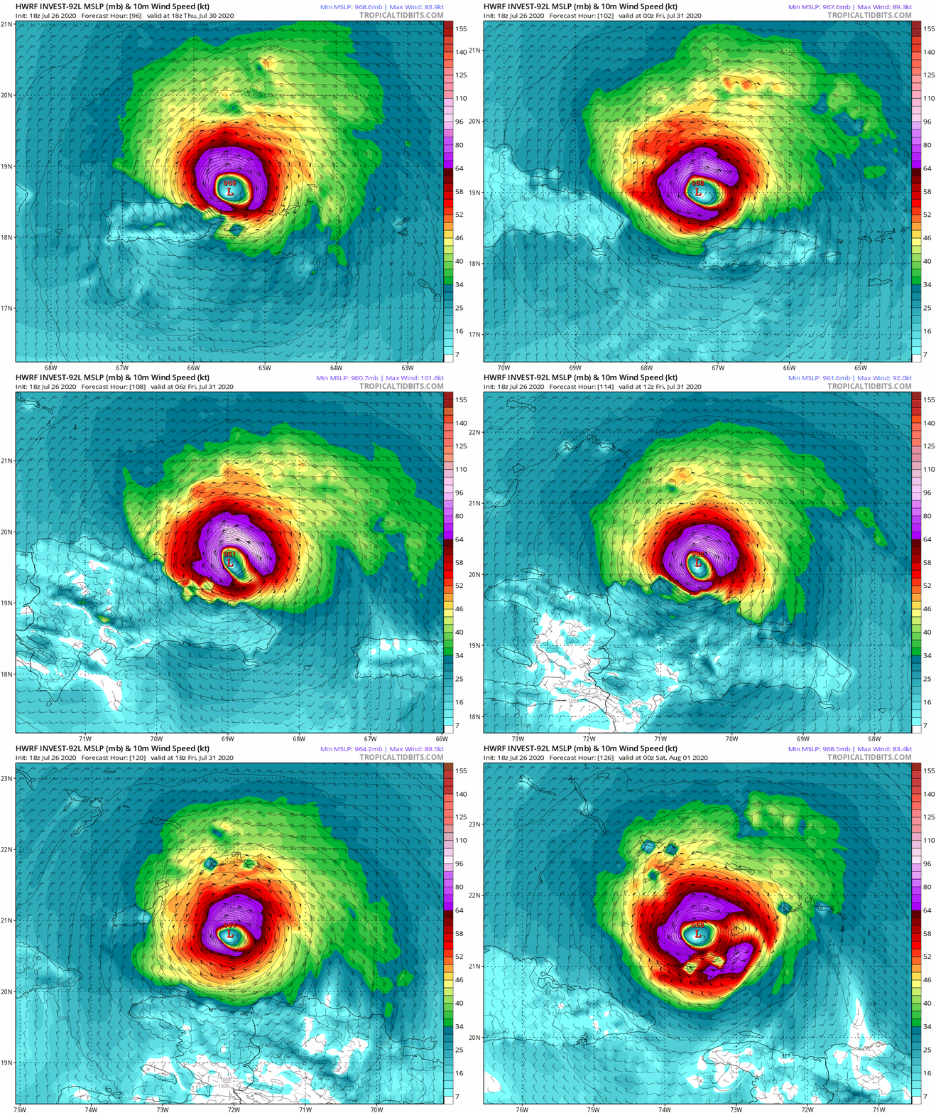
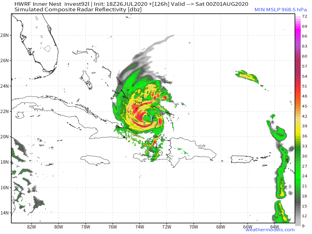
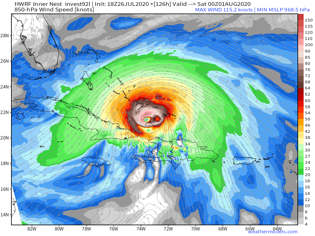
HWRF is way south heading WNW. :eek:

Image
0 likes   

User avatar
Kazmit
Category 5
Category 5
Posts: 2124
Age: 22
Joined: Mon Jul 25, 2016 8:49 am
Location: Williamsburg, VA / Bermuda

Re: ATL: INVEST 92L - Models

#474 Postby Kazmit » Sun Jul 26, 2020 7:23 pm

SFLcane wrote:HWRF is way south heading WNW. :eek:

https://iili.io/dTZBwu.gif

Only thing I can think of when I see this is a particular storm from a few years ago.
1 likes   
Igor 2010, Sandy 2012, Fay 2014, Gonzalo 2014, Joaquin 2015, Nicole 2016, Humberto 2019

I am only a tropical weather enthusiast. My predictions are not official and may or may not be backed by sound meteorological data. For official information, please refer to the NHC and NWS products.

User avatar
SFLcane
S2K Supporter
S2K Supporter
Posts: 10163
Age: 47
Joined: Sat Jun 05, 2010 1:44 pm
Location: Lake Worth Florida

Re: ATL: INVEST 92L - Models

#475 Postby SFLcane » Sun Jul 26, 2020 7:26 pm

:eek:

Image

Image
3 likes   

User avatar
CyclonicFury
Category 5
Category 5
Posts: 2025
Age: 26
Joined: Sun Jul 02, 2017 12:32 pm
Location: NC
Contact:

Re: ATL: INVEST 92L - Models

#476 Postby CyclonicFury » Sun Jul 26, 2020 7:31 pm

I have some doubts of the HWRF verifying after its dismal performance with Gonzalo. It did fairly well with Hanna though...
3 likes   
NCSU B.S. in Meteorology Class of 2021. Tropical weather blogger at http://www.cyclonicfury.com. My forecasts and thoughts are NOT official, for official forecasts please consult the National Hurricane Center.

User avatar
SFLcane
S2K Supporter
S2K Supporter
Posts: 10163
Age: 47
Joined: Sat Jun 05, 2010 1:44 pm
Location: Lake Worth Florida

Re: ATL: INVEST 92L - Models

#477 Postby SFLcane » Sun Jul 26, 2020 7:34 pm

CyclonicFury wrote:I have some doubts of the HWRF verifying after its dismal performance with Gonzalo. It did fairly well with Hanna though...


Not looking at intensity just track for now. Many days ahead
1 likes   

SconnieCane
Category 4
Category 4
Posts: 998
Joined: Thu Aug 02, 2018 5:29 pm
Location: Madison, WI

Re: ATL: INVEST 92L - Models

#478 Postby SconnieCane » Sun Jul 26, 2020 7:49 pm

AutoPenalti wrote:
Evil Jeremy wrote:
HurricaneFrances04 wrote:https://i.imgur.com/CR1LRXU.png


Here are Irma GFS ensembles from when Irma (a Cat 2 at this point, far more established for a model to latch on to, than an invest) was at 92L's longitude.

https://pbs.twimg.com/media/DIp94JiVYAEzYOD?format=jpg

Long. Week. Ahead.

and that SW dive was far more “SW” than modeled.


Irma also started off quite a bit further north than 92L is now, it needed that SW turn just to get down to 15 degrees before turning back WNW.

Of course, just a couple of weeks later Maria came into the islands south of where Irma did and still missed the CONUS to the east, so that doesn't mean a whole lot.
1 likes   

User avatar
chaser1
S2K Supporter
S2K Supporter
Posts: 5464
Age: 64
Joined: Sat Oct 15, 2005 5:59 pm
Location: Longwood, Fl

Re: ATL: INVEST 92L - Models

#479 Postby chaser1 » Sun Jul 26, 2020 7:59 pm

cycloneye wrote:Adrian.Yikes, that band of eyewall in north coast is in my house. :eek:

https://i.imgur.com/5AiiXrr.png


Luquillo area?
0 likes   
Andy D

(For official information, please refer to the NHC and NWS products.)

HurricaneFrances04
Category 2
Category 2
Posts: 597
Joined: Mon Jun 25, 2012 8:09 am
Location: Fort Lauderdale, Florida

Re: ATL: INVEST 92L - Models

#480 Postby HurricaneFrances04 » Sun Jul 26, 2020 8:07 pm

Evil Jeremy wrote:
HurricaneFrances04 wrote:https://i.imgur.com/CR1LRXU.png


Here are Irma GFS ensembles from when Irma (a Cat 2 at this point, far more established for a model to latch on to, than an invest) was at 92L's longitude.

https://pbs.twimg.com/media/DIp94JiVYAEzYOD?format=jpg

Long. Week. Ahead.


I remember Irma being a good recruve candidate, but forgot how far east those early runs were. Even the EURO was pretty far east that same cycle https://twitter.com/EricBlake12/status/903557983858290688
2 likes   


Return to “2020”

Who is online

Users browsing this forum: No registered users and 4 guests