SE TX/SW LA weather: Much cooler and WET after Tuesday
Moderator: S2k Moderators
Forum rules

The posts in this forum are NOT official forecast and should not be used as such. They are just the opinion of the poster and may or may not be backed by sound meteorological data. They are NOT endorsed by any professional institution or STORM2K.
Re: SE TX/SW LA weather: Hot and dry, temps 90's to 100+!
Looks like it will. It has picked up a lot of speed as well. At around 5:00 it was still in the Dallal area and West of Austin. Reports having it moving 30 miles an hour, so I expect the fun to begin here in a couple of hours.
0 likes
-
jasons2k

- Storm2k Executive

- Posts: 8290
- Age: 52
- Joined: Wed Jul 06, 2005 12:32 pm
- Location: The Woodlands, TX
Re: SE TX/SW LA weather: Hot and dry, temps 90's to 100+!
I got a quick .74" earlier with more on the way - nice way to start June as we sure do need all we can get 
0 likes
Re: SE TX/SW LA weather: Hot and dry, temps 90's to 100+!
No warnings yet, but a little info on the line:
Effective: 21:06 CDT on 06-02-2010
Expires: 22:30 CDT on 06-02-2010
Event: Special Weather Statement
Alert: ...SIGNIFICANT WEATHER ADVISORY...
AT 856 PM CDT...NATIONAL WEATHER SERVICE DOPPLER RADAR INDICATED
STRONG THUNDERSTORMS ALONG A LINE EXTENDING FROM BUFFALO TO HEARNE
TO NEAR LA GRANGE...MOVING EAST AT 35 MPH.
NICKEL SIZE HAIL...WINDS UP TO 50 MPH...FREQUENT CLOUD TO GROUND
LIGHTNING...BRIEF HEAVY DOWNPOURS...ARE POSSIBLE WITH THESE STORMS.
LOCATIONS IN THE PATH OF THESE STORMS INCLUDE...WELLBORN...
WASHINGTON...WADSWORTH...VANDERBILT...SHERIDAN...SHELBY...ROCK
ISLAND...ROANS PRAIRIE...QUARRY...NORTH ZULCH...NEW ULM...NADA...
MORALES...MONAVILLE...MILLICAN...LOUISE...LAKE TEXANA DAM...KURTEN...
INDUSTRY...INDEPENDENCE...IOLA...GARWOOD...FRELSBURG...EGYPT...
CORDELE...CAT SPRING...CARLOS...BEDIAS...ANDERSON...WIXON VALLEY...
SNOOK...SEALY...SAN FELIPE...PRAIRIE VIEW...PINE ISLAND...PATTISON...
NORMANGEE...NAVASOTA...MADISONVILLE...HEMPSTEAD...EL CAMPO...EDNA...
EAGLE LAKE...COLUMBUS...COLLEGE STATION...CALDWELL...BURTON...
BRYAN...BROOKSHIRE...BRENHAM AND BELLVILLE.
GUSTY WINDS MAY CAUSE SMALL TREE BRANCHES TO BE BROKEN...AND
UNSECURED OBJECTS TO BLOW AROUND. AVOID TALL OUTDOOR OBJECTS THAT
CAN ATTRACT LIGHTNING. IF YOU ARE OUTDOORS AND HEAR THUNDER...YOU ARE
CLOSE ENOUGH TO BE STRUCK BY LIGHTNING. SEEK SHELTER IN A STURDY
STRUCTURE OR AUTOMOBILE UNTIL THESE STORMS HAVE PASSED.
Instructions:
Target Area: Austin
Brazos
Burleson
Colorado
Fort Bend
Grimes
Jackson
Madison
Waller
Washington
Wharton
0 likes
-
vbhoutex

- Storm2k Executive
- Posts: 29149
- Age: 74
- Joined: Wed Oct 09, 2002 11:31 pm
- Location: Cypress, TX
- Contact:
Re: SE TX/SW LA weather: Hot and dry, temps 90's to 100+!
The line of storms is into Columbus now and moving E at 27 mph according to local ocm Tim Heller. Expected into W Houston/Katy area around 11:30 pm. Last time I looked it appears to me it might be weakening some. We need the rain, but not any severe weather. I guess I'll be up late tonight.
0 likes
Skywarn, C.E.R.T.
Please click below to donate to STORM2K to help with the expenses of keeping the site going:

Please click below to donate to STORM2K to help with the expenses of keeping the site going:
-
Yankeegirl

- Category 5

- Posts: 3417
- Age: 50
- Joined: Sun May 23, 2004 11:59 pm
- Location: Cy-Fair, Northwest Houston
- Contact:
-
Yankeegirl
- Category 5
- Posts: 3417
- Age: 50
- Joined: Sun May 23, 2004 11:59 pm
- Location: Cy-Fair, Northwest Houston
- Contact:
-
vbhoutex
- Storm2k Executive
- Posts: 29149
- Age: 74
- Joined: Wed Oct 09, 2002 11:31 pm
- Location: Cypress, TX
- Contact:
Re: SE TX/SW LA weather: Hot and dry, temps 90's to 100+!
Definitely has weakened from earlier, but it looks like we will get a longer rain. The coverage seems to extend a good deal further West than it did earlier when it was a more intense line. Leading edge now almost into the Beltway which is a couple of miles West of me. Hearing a lot of thunder.
Just looked at radar again. It appears we have a small cell intensifying quickly just to my SW. It shouldn't last long, but it could be intense for a little while.
edit:6/03-8:05 am-1.29" of rain last night
Just looked at radar again. It appears we have a small cell intensifying quickly just to my SW. It shouldn't last long, but it could be intense for a little while.
edit:6/03-8:05 am-1.29" of rain last night
0 likes
Skywarn, C.E.R.T.
Please click below to donate to STORM2K to help with the expenses of keeping the site going:
Please click below to donate to STORM2K to help with the expenses of keeping the site going:
-
jasons2k
- Storm2k Executive
- Posts: 8290
- Age: 52
- Joined: Wed Jul 06, 2005 12:32 pm
- Location: The Woodlands, TX
Re: SE TX/SW LA weather: Hot and dry, temps 90's to 100+!
.34" overnight for me
Looks like the ULL is just to our W/SW, spinning and elongating some...
Looks like the ULL is just to our W/SW, spinning and elongating some...
0 likes
-
southerngale

- Retired Staff

- Posts: 27418
- Joined: Thu Oct 10, 2002 1:27 am
- Location: Southeast Texas (Beaumont area)

 my Cowboys
 -
srainhoutx

- S2K Supporter

- Posts: 6919
- Age: 68
- Joined: Sun Jan 14, 2007 11:34 am
- Location: Haywood County, NC
- Contact:
Re: SE TX/SW LA weather: Hot and dry, temps 90's to 100+!
Interesting discussion from FWD concerning Upper Low and its location and what they are thinking regarding this vertically stacked system. Not much in the way of rainfall for my lawn, but something is better than nothing at all. More rain chances for the next couple of days it appears...
AREA FORECAST DISCUSSION...UPDATED
NATIONAL WEATHER SERVICE FORT WORTH TX
1103 AM CDT THU JUN 3 2010
.UPDATE...
VISIBLE SATELLITE IMAGERY SHOWS SOME INTERESTING FEATURES THIS
MORNING THAT WILL CONTINUE TO AFFECT NORTH TEXAS WEATHER OVER THE
NEXT 24 HOURS. THE MOST SIGNIFICANT IS THE CIRCULATION ACROSS
SOUTHEAST TEXAS. THIS SYSTEM IS A WELL DEFINED NEARLY VERTICALLY
STACKED CYCLONE IN THE MID/UPPER LEVELS WITH A SURFACE REFLECTION
OF LOW PRESSURE LOCATED NEAR HUNTSVILLE. SOME OF THE SURFACE
FEATURES ARE A BIT CONVOLUTED DUE TO THE INTENSE OVERNIGHT
CONVECTION WHICH HAS DISTORTED THE WIND FIELD TO SOME DEGREE.
HOWEVER IT APPEARS THAT THIS FEATURE HAS BEEN TAKING ON MORE
TROPICAL LIKE CHARACTERISTICS OVER THE LAST SEVERAL HOURS GIVEN
THE VERTICAL ORIENTATION OF THE LOW AND MODEL INDICATIONS OF A
WARMING MID LEVEL CORE. THIS IS CONCERNING BECAUSE CONVECTIVE
ACTIVITY HAS BEEN REGENERATING JUST NORTH OF A PRONOUNCED CYCLONIC
CENTER NEAR CLL AS INDICATED BY GRK 88D DATA. THIS ACTIVITY IS
MOVING WESTWARD AND WILL LIKELY BECOME MORE EFFICIENT AT RAINFALL
PRODUCTION ESPECIALLY IF DEEPER MOISTURE TO THE EAST CAN BE
INGESTED INTO THE SYSTEM. WILL HAVE TO MONITOR FOR POTENTIAL HEAVY
RAINFALL ACROSS THE SOUTHEAST COUNTIES THROUGH THIS AFTERNOON.
GIVEN LATEST TRENDS...HAVE RAISED POPS ACROSS THE SOUTHEAST
COUNTIES THROUGH THE AFTERNOON. LATEST 12Z GUIDANCE KEEPS A CLOSED
CIRCULATION AND SLOWLY MOVES IT EAST THROUGH THE WEEKEND...SO THIS
BEARS CLOSE WATCHING DUE TO THE POTENTIAL FOR VERY HEAVY RAINFALL
IN SOME AREAS.
THE OTHER FEATURE OF IMPORTANCE IS A SOUTHWARD MOVING OUTFLOW
BOUNDARY WHICH APPEARS TO HAVE MADE IT INTO THE NORTHERN PORTIONS
OF THE METROPLEX OVER THE LAST HOUR. THUNDERSTORM ACTIVITY COULD
DEVELOP ALONG THIS BOUNDARY LATER THIS AFTERNOON WITH ADDITIONAL
HEATING...HOWEVER MID/HIGH CLOUDINESS FROM LOW TO THE SOUTH IS
OVERSPREADING NORTH TEXAS AND MAY LIMIT THIS AFTERNOON HEATING TO
SOME DEGREE. OTHER THAN RAISING POPS IN THE SOUTHEAST...HAVE ALSO
MADE SOME ADJUSTMENTS DOWNWARD TO FORECAST HIGHS ACROSS THE
SOUTHERN HALF WHERE CLOUD COVER WILL LIKELY HANG AROUND FOR A WHILE.
91/DUNN
0 likes
Carla/Alicia/Jerry(In The Eye)/Michelle/Charley/Ivan/Dennis/Katrina/Rita/Wilma/Ike/Harvey
Member: National Weather Association
Wx Infinity Forums
http://wxinfinity.com/index.php
Facebook.com/WeatherInfinity
Twitter @WeatherInfinity
Member: National Weather Association
Wx Infinity Forums
http://wxinfinity.com/index.php
Facebook.com/WeatherInfinity
Twitter @WeatherInfinity
-
PTrackerLA

- Category 5
- Posts: 5281
- Age: 42
- Joined: Thu Oct 10, 2002 8:40 pm
- Location: Lafayette, LA
Re: SE TX/SW LA weather: Hot and dry, temps 90's to 100+!
Quite an impressive low on radar and satellite. If this were to make it into the gulf you would have to keep and eye on it. The latest NAM and GFS give us several inches of rain over the next two days with this system so hopefully we can finally start to catch up on our deficits. There has been plenty of rain 'around' lately but not so much for Lafayette. Wouldn't surprise me if some areas experience flooding with this system as this is the sort of set up that allows training showers/thunderstorms.
0 likes
-
jasons2k
- Storm2k Executive
- Posts: 8290
- Age: 52
- Joined: Wed Jul 06, 2005 12:32 pm
- Location: The Woodlands, TX
Re: SE TX/SW LA weather: Hot and dry, temps 90's to 100+!
Here is an update from Jeff Lindner as well:
I'm really wondering how they analyze a stacked low near Huntsville. On satellite and radar it looks (to me) like it's centered over NW Harris County. Maybe the pros see something I don't see.
Carefully watching stacked circulation over SE TX late this morning. Warm core center has developed with excessive rainfall focused on the northern side of the surface low noted near Huntsville. Circulation appears to be taking on warm core features similar to a tropical cyclone where excessive rainfall develops in bands during the day and near the core during the night. Will need to keep a close eye on this slow moving/meandering system for the next 24 hours or so.
I'm really wondering how they analyze a stacked low near Huntsville. On satellite and radar it looks (to me) like it's centered over NW Harris County. Maybe the pros see something I don't see.
0 likes
-
vbhoutex
- Storm2k Executive
- Posts: 29149
- Age: 74
- Joined: Wed Oct 09, 2002 11:31 pm
- Location: Cypress, TX
- Contact:
Re: SE TX/SW LA weather: Hot and dry, temps 90's to 100+!
jasons wrote:Here is an update from Jeff Lindner as well:Carefully watching stacked circulation over SE TX late this morning. Warm core center has developed with excessive rainfall focused on the northern side of the surface low noted near Huntsville. Circulation appears to be taking on warm core features similar to a tropical cyclone where excessive rainfall develops in bands during the day and near the core during the night. Will need to keep a close eye on this slow moving/meandering system for the next 24 hours or so.
I'm really wondering how they analyze a stacked low near Huntsville. On satellite and radar it looks (to me) like it's centered over NW Harris County. Maybe the pros see something I don't see.
I understand what you are saying and agree that it looks like the low center is somewhere around NW Harris or W Montgomery County. However my guess is that NWS is using pressures from different stations to find the low center.
I certainly don't like the thought of this being a warm core tropical like low. It makes me shudder ala Allison, especially with there already being excessive rainfall already reported.
0 likes
Skywarn, C.E.R.T.
Please click below to donate to STORM2K to help with the expenses of keeping the site going:
Please click below to donate to STORM2K to help with the expenses of keeping the site going:

Re: SE TX/SW LA weather: Hot and dry, temps 90's to 100+!
I agree with Jeff's update. I was thinking the same with impressive satellite image. This may become a very impressive
tropical-like rain event before its all said and done.
tropical-like rain event before its all said and done.
0 likes
The following post is NOT an official forecast and should not be used as such. It is just the opinion of the poster and may or may not be backed by sound meteorological data. It is NOT endorsed by any professional institution including storm2k.org For Official Information please refer to the NHC and NWS products.
-
srainhoutx
- S2K Supporter
- Posts: 6919
- Age: 68
- Joined: Sun Jan 14, 2007 11:34 am
- Location: Haywood County, NC
- Contact:
Re: SE TX/SW LA weather: Hot and dry, temps 90's to 100+!
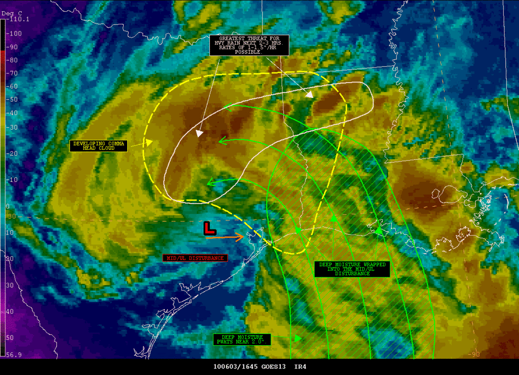
This could get interesting...
SATELLITE PRECIPITATION ESTIMATES..DATE/TIME 06/03/10 1714Z
SATELLITE ANALYSIS BRANCH/NESDIS---NPPU---TEL.301-763-8678
LATEST DATA USED: GOES-13 1615Z JBN
.
LOCATION...MISSISSIPPI...LOUISIANA...ARKANSAS...TEXAS...
.
ATTN WFOS...JAN...LIX...LCH...SHV...HGX...FWD...EWX...
ATTN RFCS...LMRFC...WGRFC...
.
EVENT...MOD/HVY RAIN ASSOCIATED WITH CONVECTION
.
SATELLITE ANALYSIS AND TRENDS...LATEST GOES WV IMAGERY SHOWS A MID/UL
DISTURBANCE OVER SE TX THAT IS SLOWLY MOVING E. DEEP MOISTURE IS BEING
PULLED INTO THIS SYSTEM FROM THE GULF OF MEXICO AS SEEN BY A VERY SMALL
MOISTURE PLUME OBER SE TX/WRN LA. PWATS IN THIS AREA ARE AVERAGING NEAR
2.0" ACROSS SE TX/WRN LA WHICH IS ABOUT 150% OF NORMAL FOR THIS TIME
OF YEAR. IR IMAGERY SHOWS A DEVELOPING COMMA HEAD CLOUD FEATURE ON THE
NRN/NERN SIDE OF THE DISTURBANCE WHERE CLOUD TOPS ARE SHOWING A STRONG
COOLING/EXPANDING TREND. THESE COOLING/EXPANDING CLOUD TOPS ARE ASSOCIATED
WITH CONVECTION THAT APPEARS TO BE ORGANIZING INTO SINGLE WSW/ENE ORIENTED
BAND THAT EXTENDS INTO NRN LA. THIS BAND IS THEN BEING PULLED TOWARD THE
MID/UL DISTURBANCE. THIS COULD LEAD TO SOME TRAINING CONVECTION ACROSS THE
DISCUSSION AREA WITH THE HEAVIEST RAIN BEING CONCENTRATED INTO A SINGLE
CONVECTIVE BAND EXTENDING FROM MILAM COUNTY IN TX ENE TO JACKSON/WINN
PARISHES IN LA THE NEXT FEW HRS. RAIN FALL RATES MAY EASILY BE IN THE
1-1.5"/HR RANGE WITH THIS CONVECTION BASED ON THE AVAILABLE MOISTURE
AND COOLING/EXPANDING TAKING PLACE IN IR IMAGERY. THE CONVECTION SHOULD
PERSIST FOR THE NEXT SEVERAL HRS AS THE MID/UL DISTURBANCE CONTINUES TO
TAP INTO THE DEEP MOISTURE IN PLACE OVER THE REGION. THIS SHOULD RESULT
IN MOD/HVY RAIN ACROSS PARTS OF SE TX/WRN LA.
.
AN ANNOTATED SATELLITE GRAPHIC SHOWING THE THREAT FOR HVY RAIN WILL BE
AVAILABLE SHORTLY AT THE WEB ADDRESS LISTED BELOW.
.
SHORT TERM OUTLOOK VALID 17Z-20Z...MEDIUM CONFIDENCE FACTOR IN THE SHORT
TERM OUTLOOK BASED ON RECENT TRENDS IN SATELLITE IMAGERY. CLOUDS TOPS
ARE SHOWING A GOOD COOLING/EXPANDING TREND IN IR IMAGERY SUGGESTING
THAT THE COMMA HEAD FEATURE ASSOCIATED WITH THE MID/UL DISTURBANCE IS
BECOMING BETTER ORGANIZED. RAIN RATES ARE PROBABLY INCREASING AS WELL
AS CONVECTION BECOMES ORGANIZED INTO A BAND FEATURE. THIS SHOULD ALLOW
FOR A SWATH OF HVY RAIN ACROSS PARTS OF SE TX/WRN LA WHERE THIS BAND
SETS UP AN PERSISTS FOR A TIME.
0 likes
Carla/Alicia/Jerry(In The Eye)/Michelle/Charley/Ivan/Dennis/Katrina/Rita/Wilma/Ike/Harvey
Member: National Weather Association
Wx Infinity Forums
http://wxinfinity.com/index.php
Facebook.com/WeatherInfinity
Twitter @WeatherInfinity
Member: National Weather Association
Wx Infinity Forums
http://wxinfinity.com/index.php
Facebook.com/WeatherInfinity
Twitter @WeatherInfinity
-
TeamPlayersBlue

- Category 5
- Posts: 3531
- Joined: Tue Feb 02, 2010 1:44 am
- Location: Denver/Applewood, CO
nice pic, it does look very interesting and when i saw the radar, the first thing i thought was "if i didnt know any better, i would have thought a strong tropical storm made landfall overnight."
With it taking on warm core/ tropical characteristics, this feature will grab more attention no doubt. I would expect the area just ESE of the low to begin to fill in with moisture. The whole area is filled with clouds so that may hold back the Low from blowing up.
Here in Sugar Land it has been dumping with rain for about the last 30 minutes. No rain gauge here . Just temp and humidity, promise to upgrade when i graduate this summer
With it taking on warm core/ tropical characteristics, this feature will grab more attention no doubt. I would expect the area just ESE of the low to begin to fill in with moisture. The whole area is filled with clouds so that may hold back the Low from blowing up.
Here in Sugar Land it has been dumping with rain for about the last 30 minutes. No rain gauge here
0 likes
Personal Forecast Disclaimer:
The posts in this forum are NOT official forecast and should not be used as such. They are just the opinion of the poster and may or may not be backed by sound meteorological data. They are NOT endorsed by any professional institution or storm2k.org. For official information, please refer to the NHC and NWS products.
The posts in this forum are NOT official forecast and should not be used as such. They are just the opinion of the poster and may or may not be backed by sound meteorological data. They are NOT endorsed by any professional institution or storm2k.org. For official information, please refer to the NHC and NWS products.
-
srainhoutx
- S2K Supporter
- Posts: 6919
- Age: 68
- Joined: Sun Jan 14, 2007 11:34 am
- Location: Haywood County, NC
- Contact:
Re: SE TX/SW LA weather: Hot and dry, temps 90's to 100+!
Heavy tropical rains in NW Harris County. My yard has finally received some beneficial rainfall. 
0 likes
Carla/Alicia/Jerry(In The Eye)/Michelle/Charley/Ivan/Dennis/Katrina/Rita/Wilma/Ike/Harvey
Member: National Weather Association
Wx Infinity Forums
http://wxinfinity.com/index.php
Facebook.com/WeatherInfinity
Twitter @WeatherInfinity
Member: National Weather Association
Wx Infinity Forums
http://wxinfinity.com/index.php
Facebook.com/WeatherInfinity
Twitter @WeatherInfinity
-
jasons2k
- Storm2k Executive
- Posts: 8290
- Age: 52
- Joined: Wed Jul 06, 2005 12:32 pm
- Location: The Woodlands, TX
Re: SE TX/SW LA weather: Hot and dry, temps 90's to 100+!
Hmm, just saw this from NWS HGX, even though it's from 12:30
.AVIATION...
A LOW CONFIDENCE FORECAST. UPPER LOW OVER HOUSTON WILL DRIFT SLOWLY
EAST SOUTHEAST. MODELS TYPICALLY HANDLE THESE SYSTEMS VERY POORLY.
BOTH NAM/GFS HAVE TRENDED WETTER ON THE 12Z RUN. GIVEN LARGE EXPANSE
OF PRECIP...EVEN IF LOW MOVES TOWARD TX/LA BORDER AS ADVERTISED
THINK SWATH OF PRECIP AND SCATTERED CONVECTION WILL STILL AFFECT
HOUSTON TERMINALS THROUGH THE DAY FRIDAY. HAVE TEMPOED SHRA/TSRA
THROUGH 22Z...THEN GENERALLY KEPT VCSH/VCTS FOR THE REMAINDER OF THE
PERIOD. CONFIDENCE IS HIGHEST THAT NORTHWEST AREAS AROUND KCLL WILL
DRY OUT THIS EVENING SO KEPT THIS AREA DRY AFTER 02Z. PERIODS OF
MVFR CEILINGS ARE LIKELY THROUGH FRIDAY MORNING AS LOW CLOUDS WRAP
AROUND THE UPPER LOW. WEST TO NORTHWEST WINDS OF 8-12 KTS ARE
EXPECTED.
0 likes
-
jasons2k
- Storm2k Executive
- Posts: 8290
- Age: 52
- Joined: Wed Jul 06, 2005 12:32 pm
- Location: The Woodlands, TX
NWS does not seem too bullish or concerned with the rainfall/flooding potential overnight.
I am not a pro met, but in my opinion, this has "gotcha" written all over it. It's these stationary warm-core systems that can dump tremendous amounts of rain somewhere, especially where storms train or core rains setup. I think there should a flood watch because somebody is going to get dumped-on overnight. And my non-scientific theory is that since there isn't much concern over this....watch out! Somebody will wake-up tomorrow and wonder what happened.
I am not a pro met, but in my opinion, this has "gotcha" written all over it. It's these stationary warm-core systems that can dump tremendous amounts of rain somewhere, especially where storms train or core rains setup. I think there should a flood watch because somebody is going to get dumped-on overnight. And my non-scientific theory is that since there isn't much concern over this....watch out! Somebody will wake-up tomorrow and wonder what happened.
0 likes
Return to “USA & Caribbean Weather”
Who is online
Users browsing this forum: No registered users and 96 guests