
Texas Summer 2019
Moderator: S2k Moderators
Forum rules

The posts in this forum are NOT official forecast and should not be used as such. They are just the opinion of the poster and may or may not be backed by sound meteorological data. They are NOT endorsed by any professional institution or STORM2K.
-
bubba hotep

- S2K Supporter

- Posts: 6014
- Joined: Wed Dec 28, 2016 1:00 am
- Location: Collin County Texas
Re: Texas Summer 2019
Need to watch these cells to the NE of DFW or any new cells that develop for the potential to grow upscale into svr clusters with some supercell features. SPC mesoanalysis is showing upwards of 4,000 surface based CAPE and SCP over 4 for the NE burbs. Large hail would be a concern along with high winds.
0 likes
Winter time post are almost exclusively focused on the DFW area.
-
bubba hotep
- S2K Supporter
- Posts: 6014
- Joined: Wed Dec 28, 2016 1:00 am
- Location: Collin County Texas
Re: Texas Summer 2019
Some what rare svr storms coming in from the NE.
1 likes
Winter time post are almost exclusively focused on the DFW area.
Re: Texas Summer 2019
bubba hotep wrote:Some what rare svr storms coming in from the NE.
Definitely a different look on radar. They are taking their sweet time to get here though.
0 likes


Re: Texas Summer 2019
Sneaky move to attack from the northeast like that. Maybe the cell north of Sherman could end up impacting the metro area.
Edit: Or even one of the closer storms.
Edit: Or even one of the closer storms.
0 likes

Re: Texas Summer 2019
This is your typical summer rains that you see in Florida and other places closer to the big ponds, on occasion here when there is a ridge to the north and retrograding weakness. Probably limited severe if any, but tropical like torrential downpours...slow movers if lucky to see one.
1 likes
The above post and any post by Ntxw is NOT an official forecast and should not be used as such. It is just the opinion of the poster and may or may not be backed by sound meteorological data. It is NOT endorsed by any professional institution including Storm2k. For official information, please refer to NWS products.
Help support Storm2K!
-
Haris

- Category 5

- Posts: 1814
- Joined: Mon Nov 27, 2017 8:19 pm
- Location: ( Bee Cave) West Austin, Texas
Re: Texas Summer 2019
Low pressure looks to track right over me. Fun
2 likes
Weather geek and a storm spotter in West Austin. Not a degreed meteorologist. Big snow fan. Love rain and cold! Despise heat!
-
Brent
- S2K Supporter
- Posts: 38740
- Age: 37
- Joined: Sun May 16, 2004 10:30 pm
- Location: Tulsa Oklahoma
- Contact:
Re: Texas Summer 2019
Nice thunder here not a lot of rain so far but for July eve I'll take it 
Edit total downpour now almost sounds like hail
And now i see some pea sized hail
Edit total downpour now almost sounds like hail
And now i see some pea sized hail
2 likes
#neversummer
Re: Texas Summer 2019
DFW airport dropped from 96 to 83.
Southeast style summer ftw.
Southeast style summer ftw.
4 likes
The above post and any post by Ntxw is NOT an official forecast and should not be used as such. It is just the opinion of the poster and may or may not be backed by sound meteorological data. It is NOT endorsed by any professional institution including Storm2k. For official information, please refer to NWS products.
Help support Storm2K!
Help support Storm2K!
Re: Texas Summer 2019
Ntxw wrote:DFW airport dropped from 96 to 83.
Southeast style summer ftw.
The outflow came through Irving earlier and made it feel pleasant outside. A little rain has started falling but nothing heavy. From my view, Las Colinas to my east is seeing heavier rain.
1 likes
-
bubba hotep
- S2K Supporter
- Posts: 6014
- Joined: Wed Dec 28, 2016 1:00 am
- Location: Collin County Texas
Re: Texas Summer 2019
Brent wrote:Nice thunder here not a lot of rain so far but for July eve I'll take it
Edit total downpour now almost sounds like hail
And now i see some pea sized hail
The first storm coming in from the NE collapsed and spit an outflow right before moving in and I thought that was it. Then that other cell popped up and moved in from the north. It slammed us with some hail and high wind.

Got a lightning strike that was a bit too close and I nearly dropped my phone
7 likes
Winter time post are almost exclusively focused on the DFW area.
-
weatherdude1108
- Category 5
- Posts: 4228
- Joined: Tue Dec 13, 2011 1:04 pm
- Location: Northwest Austin/Cedar Park, TX
Re: Texas Summer 2019
Under a significant weather advisory here. 50mph gusts and pea hail.
I hear wind outside and see lightning in distance. I'll post in the morning.
Special Weather Statement
National Weather Service Austin/San Antonio TX
1114 PM CDT Sat Jun 29 2019
TXZ171>173-188-190>194-209-300515-
Blanco TX-Gillespie TX-Williamson TX-Bastrop TX-Llano TX-Fayette TX-
Hays TX-Burnet TX-Lee TX-Travis TX-
1114 PM CDT Sat Jun 29 2019
...SIGNIFICANT WEATHER ADVISORY FOR WILLIAMSON...NORTHERN HAYS...
TRAVIS...NORTHERN BLANCO...NORTHEASTERN GILLESPIE...LLANO...
BASTROP...LEE...CENTRAL FAYETTE AND BURNET COUNTIES UNTIL 1215 AM
CDT...
At 1111 PM CDT, Doppler radar was tracking strong thunderstorms along
a line extending from 7 miles northeast of Tow to near Dime Box.
Movement was southwest at 40 mph.
Wind gusts up to 50 mph will be possible with these storms. Some pea
size hail will also be possible.
Locations impacted include...
Austin, Round Rock, Cedar Park, Georgetown, Pflugerville, Taylor,
Elgin, Bastrop, Burnet, Marble Falls, Kingsland, Giddings,
Smithville, Llano, Dripping Springs, Granger, Bertram, Lexington,
Round Mountain and Serenada.
2 likes
The preceding post is NOT an official forecast, and should not be used as such. It is only the opinion of the poster and may or may not be backed by sound meteorological data. It is NOT endorsed by any professional institution including storm2k.org. For Official Information please refer to the NHC and NWS products.
-
weatherdude1108
- Category 5
- Posts: 4228
- Joined: Tue Dec 13, 2011 1:04 pm
- Location: Northwest Austin/Cedar Park, TX
Re: Texas Summer 2019
Got about an inch of rain in the wee hours this morning. 1.6 inches since Thursday. I will gladly take this, especially approaching July.
2 likes
The preceding post is NOT an official forecast, and should not be used as such. It is only the opinion of the poster and may or may not be backed by sound meteorological data. It is NOT endorsed by any professional institution including storm2k.org. For Official Information please refer to the NHC and NWS products.
-
Haris
- Category 5
- Posts: 1814
- Joined: Mon Nov 27, 2017 8:19 pm
- Location: ( Bee Cave) West Austin, Texas
Re: Texas Summer 2019
Rumbles of thunder and heavy rainfall this morning, 66f.
Love it. Is it July ???
Love it. Is it July ???
3 likes
Weather geek and a storm spotter in West Austin. Not a degreed meteorologist. Big snow fan. Love rain and cold! Despise heat!
-
South Texas Storms

- Professional-Met

- Posts: 4256
- Joined: Thu Jun 24, 2010 12:28 am
- Location: Houston, TX
Re: Texas Summer 2019
The MCS made it to SA early this morning bringing another 1-2 inches of rain there which is awesome! I hope this pattern lasts all summer! But unfortunately I think we may dry up as we head later into July and August.
0 likes

Re: Texas Summer 2019
Radar filling in a little bit around and in DFW? Cell movement is...odd.
0 likes
Graduate Meteorology Student at the University of Oklahoma!
All opinions independent of employers and the university.
All opinions independent of employers and the university.
-
weatherdude1108
- Category 5
- Posts: 4228
- Joined: Tue Dec 13, 2011 1:04 pm
- Location: Northwest Austin/Cedar Park, TX
Re: Texas Summer 2019
I guess I'll go into hibernation after Wednesday, at least until late next week, when there MAY be some showers/storms along a front, I guess. The time of year is against the odds of this happening. Been a nice wet period.
Welcome to July.
Bob Rose:
Monday, July 1, 2019 3:10 PM
July weather is starting off warm, humid and fairly quiet across Central and South Texas. However, scattered rain showers and thunderstorms will be possible this afternoon and each afternoon Tuesday through Thursday as a moist and moderately unstable atmosphere continues in place. Monday's weather maps showed a trough of low pressure in the upper atmosphere stretching from Northeast Texas to the Lower Rio Grande Valley. This trough is predicted to remain over the area for the next couple of days, pulling abundant moisture inland from the Gulf of Mexico. Weak atmospheric lift associated with the upper trough combined with warming afternoon temperatures is expected to cause the development of scattered rain and storms.
This afternoon, the most favorable area for rain and thunderstorms is forecast to be along and east of Interstate 35. Here, the probability for rain will generally be near 30 percent. To the west, just a slight chance for rain is forecast across the Hill Country. For locations that do happen to see rain, totals should average only around a quarter inch. Some of today's thunderstorms may produce strong and gusty winds, but the overall severe weather threat will be low. The rain activity should diminish around sunset. Today's sky will be partly cloudy and temperatures should peak around 90 degrees.
Forecast solutions call for an area of tropical moisture to surge north into Texas Tuesday into Wednesday. This increased amount of moisture will lead to a better coverage of rain showers and thunderstorms for locations along and east of Interstate 35 Tuesday afternoon and evening. The probability for rain here will generally be near 30-40 percent. Across the Hill Country, the probability for rain will continue at 20 percent. For locations that do see rain, totals are predicted to average between 0.25 and 0.5 inches, with isolated totals to near 1 inch possible. Expect a partly to mostly cloudy sky with high temperatures near 90 degrees.
For Wednesday, the probability for afternoon and evening rain and thunderstorms is forecast to be near 50-60 percent for locations along and east of Interstate and near 20-30 percent across the Hill Country. Rain amounts are again predicted to average between 0.25 and 0.5 inches, with isolated totals to near 1 inch possible. Under a partly to mostly cloudy sky, high temperatures should again be around 90 degrees.
The chance for rain is forecast to decrease to 20 percent Thursday as the upper trough lifts to the northwest and the flow of Gulf moisture decreases. Some brief, spotty afternoon showers will be possible, but coverage should be fairly low. Rain amounts, if any, will total less than a quarter inch. In general, weather conditions on Independence Day should be mostly sunny and warm, with high temperatures mostly in the low 90s. Any showers that do happen to develop should diminish by evening, limiting impacts to evening fireworks shows.
A mostly sunny, dry and warm pattern is predicted to take shape Friday as a weak ridge of high pressure spreads over Texas out of the Southeastern US. The ridge is forecast to remain over our area this weekend and through much of next week, producing a weather pattern fairly typical of early July. The sky will be mostly sunny and temperatures will be fairly hot. High temperatures Friday will be in the low to mid-90s, warming to the middle 90s over the weekend.
The outlook for next week calls for few changes early in the week with some possible changes late week. The ridge of high pressure is forecast to be centered over Texas Monday and Tuesday, but is predicted to shift to the Desert Southwest for the second half of next week. With the ridge shifting west, it will open the door for weak cold front to possibly sink south into Texas late next week. Forecasts indicate a small area of rain showers and thunderstorms may accompany the cold front. High temperatures next week are forecast to be mostly in the middle to upper 90s.
Tropical Weather Update
Weather conditions remain very quiet across the tropical Atlantic. There are no features in place which pose a threat for tropical clone development for at least the next 5 days. Satellite images show a large area of Saharan dust located between the west coast of Africa and the Lesser Antilles. This area of dust creates a stable atmosphere and limits the development of tropical cyclones.
In the eastern tropical Pacific, tropical storm Barbara was located about 930 miles south-southwest of the southern tip of Baja, California, moving to the west at 16 mph. Maximum sustained winds are near 70 mph and Barbara is expected to become a hurricane later today, gathering significant strength during the next day or two. Barbara is forecast to continue moving off to the west-northwest over the next few days, having no impact on Mexico.
June Weather Recap
June weather was wetter than normal, with temperatures averaging not too far from the long-term climatological normal. Fortunately, there was only one period of extremely hot temperatures around June 8th. Periods of rain and clouds had a moderating effect on the temperature.
June temperatures averaged near normal to slightly above normal across most of the region. The warmest area, relative to normal, was across the middle Texas coast where readings averaged 1-2 degrees above normal. For comparison, during June 2018, temperatures averaged 2-4 degrees above normal.
In Austin, the June temperature at Camp Mabry averaged 88.2 degrees, which is exactly normal. The highest temperature for the month was 98 degrees on the 8th and 9th. There have not been any triple digit temperatures recorded so far this year. For comparison, In June 2018, Camp Mabry's temperature 4.3 degrees above normal and there were 11 triple-digit readings. Austin-Bergstrom's June temperature averaged 82.3 degrees, which is 1.3 degrees above normal. The highest temperature recorded was 98 degrees on June 8th. Austin-Bergstrom has not recorded any triple-digit temperatures so far this year. For comparison, in June 2018, Austin-Bergstrom's temperature averaged 4.4 degrees above normal and there were 4 triple-digit temperatures.
Rainfall was above normal at most locations across the region during June. In fact, many locations saw totals between 2-3 inches above normal. The greatest departure from normal was across Wharton and Matagorda Counties, where June totals were more than 8 inches above normal.
https://www.lcra.org/water/river-and-we ... ather.aspx
1 likes
The preceding post is NOT an official forecast, and should not be used as such. It is only the opinion of the poster and may or may not be backed by sound meteorological data. It is NOT endorsed by any professional institution including storm2k.org. For Official Information please refer to the NHC and NWS products.
-
Texas Snowman

- Storm2k Moderator

- Posts: 6197
- Joined: Fri Jan 25, 2008 11:29 am
- Location: Denison, Texas
Re: Texas Summer 2019
Lightning, thunder and rain in Denison.
On July 1st, no less.
We’re in month #7 now and the year is more than half over. Let the march towards fall and winter begin.

On July 1st, no less.
We’re in month #7 now and the year is more than half over. Let the march towards fall and winter begin.
2 likes
The above post and any post by Texas Snowman is NOT an official forecast and should not be used as such. It is just the opinion of the poster and may or may not be backed by sound meteorological data. It is NOT endorsed by any professional institution including storm2k.org. For official information, please refer to NWS products.
-
Brent
- S2K Supporter
- Posts: 38740
- Age: 37
- Joined: Sun May 16, 2004 10:30 pm
- Location: Tulsa Oklahoma
- Contact:
Re: Texas Summer 2019
Texas Snowman wrote:Lightning, thunder and rain in Denison.
On July 1st, no less.
We’re in month #7 now and the year is more than half over. Let the march towards fall and winter begin.
Raining for the 3rd time today here
On July 1st
The countdown to fall and winter is on
2 likes
#neversummer
-
bubba hotep
- S2K Supporter
- Posts: 6014
- Joined: Wed Dec 28, 2016 1:00 am
- Location: Collin County Texas
Re: Texas Summer 2019
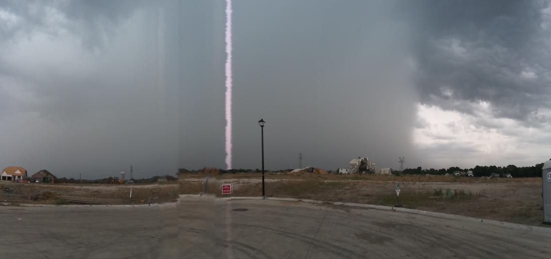
Nice storm to my NW earlier this evening.

3 likes
Winter time post are almost exclusively focused on the DFW area.
-
weatherdude1108
- Category 5
- Posts: 4228
- Joined: Tue Dec 13, 2011 1:04 pm
- Location: Northwest Austin/Cedar Park, TX
Re: Texas Summer 2019
Just thought I'd check the long-range on a whim. Didn't expect this decent QPF. Intriguing(?). The GEFS is more believable.


0 likes
The preceding post is NOT an official forecast, and should not be used as such. It is only the opinion of the poster and may or may not be backed by sound meteorological data. It is NOT endorsed by any professional institution including storm2k.org. For Official Information please refer to the NHC and NWS products.
Return to “USA & Caribbean Weather”
Who is online
Users browsing this forum: Google Adsense [Bot] and 76 guests