WPAC: GONI - Post-Tropical
Moderator: S2k Moderators

Re: WPAC: GONI - Typhoon
2020OCT31 004000 7.6 905.0 158.0 7.6 7.8 7.8 NO LIMIT OFF OFF OFF OFF 18.07 -80.52 EYE 9 IR 24.4 15.20 -128.66 ARCHER HIM-8 22.6
0 likes
Very useful information on the Dvorak Technique --
https://severe.worldweather.wmo.int/TCF ... kBeven.pdf
https://severe.worldweather.wmo.int/TCF ... kBeven.pdf

Re: WPAC: GONI - Typhoon
160 knots, not even Hagibis or Halong got this during operational 
0 likes
ヤンデレ女が寝取られるているのを見たい!!!
ECMWF ensemble NWPAC plots: https://ecmwfensnwpac.imgbb.com/
Multimodel NWPAC plots: https://multimodelnwpac.imgbb.com/
GFS Ensemble NWPAC plots (16 & 35 day forecast): https://gefsnwpac.imgbb.com/
Plots updated automatically
ECMWF ensemble NWPAC plots: https://ecmwfensnwpac.imgbb.com/
Multimodel NWPAC plots: https://multimodelnwpac.imgbb.com/
GFS Ensemble NWPAC plots (16 & 35 day forecast): https://gefsnwpac.imgbb.com/
Plots updated automatically
-
euro6208
Re: WPAC: GONI - Typhoon
Weather Dude wrote:22W GONI 201031 0000 15.3N 128.8E WPAC 160 895
Sub 900mb!
Remember that's just an estimate.
It was likely a sub 900mb typhoon for quite some time now. Very compact typhoon so the pressure gradient is very tight. It could be anywhere from 890mb to 870mb.
0 likes
-
ElectricStorm

- Category 5

- Posts: 5141
- Age: 25
- Joined: Tue Aug 13, 2019 11:23 pm
- Location: Norman, OK
Re: WPAC: GONI - Typhoon
euro6208 wrote:Weather Dude wrote:22W GONI 201031 0000 15.3N 128.8E WPAC 160 895
Sub 900mb!
Remember that's just an estimate.
It was likely a sub 900mb typhoon for quite some time now. Very compact typhoon so the pressure gradient is very tight. It could be anywhere from 890mb to 870mb.
I highly doubt is 870 but it could be in the 880's. Really wish recon was out there
0 likes
B.S Meteorology, University of Oklahoma '25
Please refer to the NHC, NWS, or SPC for official information.
Please refer to the NHC, NWS, or SPC for official information.
Re: WPAC: GONI - Typhoon
Hayabusa wrote:160 knots, not even Hagibis or Halong got this during operational
Indeed. Was good to see both storms get a boost in post season analysis. Both were handled well there, especially Halong (165/888).
2 likes
Very useful information on the Dvorak Technique --
https://severe.worldweather.wmo.int/TCF ... kBeven.pdf
https://severe.worldweather.wmo.int/TCF ... kBeven.pdf
Re: WPAC: GONI - Typhoon
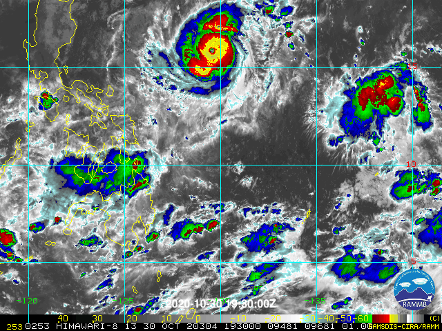
Goni is expanding looks like it is trying to get that eye done
0 likes
ヤンデレ女が寝取られるているのを見たい!!!
ECMWF ensemble NWPAC plots: https://ecmwfensnwpac.imgbb.com/
Multimodel NWPAC plots: https://multimodelnwpac.imgbb.com/
GFS Ensemble NWPAC plots (16 & 35 day forecast): https://gefsnwpac.imgbb.com/
Plots updated automatically
ECMWF ensemble NWPAC plots: https://ecmwfensnwpac.imgbb.com/
Multimodel NWPAC plots: https://multimodelnwpac.imgbb.com/
GFS Ensemble NWPAC plots (16 & 35 day forecast): https://gefsnwpac.imgbb.com/
Plots updated automatically
-
Iceresistance

- Category 5
- Posts: 9579
- Age: 22
- Joined: Sat Oct 10, 2020 9:45 am
- Location: Tecumseh, OK/Norman, OK
Re: WPAC: GONI - Typhoon
Weather Dude wrote:euro6208 wrote:What is preventing this from getting an 8.0 dvorak?
Probably not a thick enough/fully complete CDG ring?
The CDG ring on Windy.com is around 90-95% complete.
0 likes
Bill 2015 & Beta 2020
Winter 2020-2021
All observations are in Tecumseh, OK unless otherwise noted.
Winter posts are focused mainly for Oklahoma & Texas.
Take any of my forecasts with a grain of salt, refer to the NWS, SPC, and NHC for official information
Never say Never with weather! Because ANYTHING is possible!
Winter 2020-2021
All observations are in Tecumseh, OK unless otherwise noted.
Winter posts are focused mainly for Oklahoma & Texas.
Take any of my forecasts with a grain of salt, refer to the NWS, SPC, and NHC for official information
Never say Never with weather! Because ANYTHING is possible!
Re: WPAC: GONI - Typhoon
Eye temp cooling, WMG pixels gone. CDO starting to warm a bit too; inner eyewall losing the battle finally.
0 likes
Very useful information on the Dvorak Technique --
https://severe.worldweather.wmo.int/TCF ... kBeven.pdf
https://severe.worldweather.wmo.int/TCF ... kBeven.pdf
-
euro6208
Re: WPAC: GONI - Typhoon
Highteeld wrote:Hayabusa wrote:160 knots, not even Hagibis or Halong got this during operational
Indeed. Was good to see both storms get a boost in post season analysis. Both were handled well there, especially Halong (165/888).
Good candidate for an increase post season.
0 likes
-
mrbagyo

- Category 5
- Posts: 3963
- Age: 33
- Joined: Thu Apr 12, 2012 9:18 am
- Location: 14.13N 120.98E
- Contact:
Re: WPAC: GONI - Typhoon
It's moving SW holy mackerel

5 likes
The posts in this forum are NOT official forecast and should not be used as such. They are just the opinion of the poster and may or may not be backed by sound meteorological data. They are NOT endorsed by any professional institution or storm2k.org. For official information, please refer to RSMC, NHC and NWS products.
-
tolakram
- Admin

- Posts: 20179
- Age: 62
- Joined: Sun Aug 27, 2006 8:23 pm
- Location: Florence, KY (name is Mark)
Re: WPAC: GONI - Typhoon
0 likes
M a r k
- - - - -
Join us in chat: Storm2K Chatroom Invite. Android and IOS apps also available.
The posts in this forum are NOT official forecasts and should not be used as such. Posts are NOT endorsed by any professional institution or STORM2K.org. For official information and forecasts, please refer to NHC and NWS products.

Re: WPAC: GONI - Typhoon
Reminds me a lot of Wilma on visible when it peaked. The wobbling of the eye and the spiral of deep convection on IR show this is finally succumbing to the outer eyewall. Hopefully this leaves Goni vulnerable to the expected increase in shear.
1 likes
Irene '11 Sandy '12 Hermine '16 5/15/2018 Derecho Fay '20 Isaias '20 Elsa '21 Henri '21 Ida '21
I am only a meteorology enthusiast who knows a decent amount about tropical cyclones. Look to the professional mets, the NHC, or your local weather office for the best information.
I am only a meteorology enthusiast who knows a decent amount about tropical cyclones. Look to the professional mets, the NHC, or your local weather office for the best information.
-
euro6208
Re: WPAC: GONI - Typhoon
1900hurricane wrote:How do you estimate this storm? It's so small that nothing works right.
One thing is for sure. This is not the normal cat 5.
0 likes
Re: WPAC: GONI - Typhoon
Wilma 2.0

3 likes
Irene '11 Sandy '12 Hermine '16 5/15/2018 Derecho Fay '20 Isaias '20 Elsa '21 Henri '21 Ida '21
I am only a meteorology enthusiast who knows a decent amount about tropical cyclones. Look to the professional mets, the NHC, or your local weather office for the best information.
I am only a meteorology enthusiast who knows a decent amount about tropical cyclones. Look to the professional mets, the NHC, or your local weather office for the best information.
-
ElectricStorm
- Category 5
- Posts: 5141
- Age: 25
- Joined: Tue Aug 13, 2019 11:23 pm
- Location: Norman, OK
Re: WPAC: GONI - Typhoon
New JTWC forecast out. Anything south of that line is likely a Cat 5 landfall. This EWRC is the only hope...
0 likes
B.S Meteorology, University of Oklahoma '25
Please refer to the NHC, NWS, or SPC for official information.
Please refer to the NHC, NWS, or SPC for official information.


Re: WPAC: GONI - Typhoon
Weather Dude wrote:New JTWC forecast out. Anything south of that line is likely a Cat 5 landfall. This EWRC is the only hope...
I’ve seen comparisons to Haiyan being mentioned...this better not have a successful eyewall meld. The 18z HWRF is the best-case scenario, and even that has a Cat 3 landfall near Manila.
0 likes
Irene '11 Sandy '12 Hermine '16 5/15/2018 Derecho Fay '20 Isaias '20 Elsa '21 Henri '21 Ida '21
I am only a meteorology enthusiast who knows a decent amount about tropical cyclones. Look to the professional mets, the NHC, or your local weather office for the best information.
I am only a meteorology enthusiast who knows a decent amount about tropical cyclones. Look to the professional mets, the NHC, or your local weather office for the best information.
-
dexterlabio
- Category 5
- Posts: 3503
- Joined: Sat Oct 24, 2009 11:50 pm
Re: WPAC: GONI - Typhoon
Although Wilma was impressive that it was a large system but its original was rather microsmall..I believe Goni's small eye is even larger in comparison
0 likes
Personal Forecast Disclaimer:
The posts in this forum are NOT official forecast and should not be used as such. They are just the opinion of the poster and may or may not be backed by sound meteorological data. They are NOT endorsed by any professional institution or storm2k.org. For official information, please refer to the NHC and NWS products.
The posts in this forum are NOT official forecast and should not be used as such. They are just the opinion of the poster and may or may not be backed by sound meteorological data. They are NOT endorsed by any professional institution or storm2k.org. For official information, please refer to the NHC and NWS products.
-
euro6208
Re: WPAC: GONI - Typhoon
UW - CIMSS
ADVANCED DVORAK TECHNIQUE
ADT-Version 9.0
Tropical Cyclone Intensity Algorithm
----- Current Analysis -----
Date : 31 OCT 2020 Time : 011000 UTC
Lat : 15:10:48 N Lon : 128:30:35 E
CI# /Pressure/ Vmax
7.6 / 902.6mb/158.0kt
Final T# Adj T# Raw T#
7.6 7.6 7.6
Estimated radius of max. wind based on IR : 8 km
Center Temp : +13.7C Cloud Region Temp : -80.1C
Scene Type : EYE
Subtropical Adjustment : OFF
Extratropical Adjustment : OFF
Positioning Method : ARCHER POSITIONING
Ocean Basin : WEST PACIFIC
Dvorak CI > MSLP Conversion Used : CKZ Method
Tno/CI Rules : Constraint Limits : NO LIMIT
Weakening Flag : OFF
Rapid Dissipation Flag : OFF
C/K/Z MSLP Estimate Inputs :
- Average 34 knot radii : 103nmi
- Environmental MSLP : 1006mb
Satellite Name : HIM-8
Satellite Viewing Angle : 22.7 degrees
****************************************************
0 likes
Who is online
Users browsing this forum: No registered users and 10 guests