Ninety knots roughly equates to 105 mph, But with a pressure of 970 mb I wouldn't be surprised if the next advisory has the winds at 110 mph. The likelihood of Cat3 intensity later today was mentioned in an earlier comment or two, but I think Cat4 by sometime this afternoon is a real possibility.
ATL: ERIN - Hurricane - Discussion
Moderators: hurricanetrack, S2k Moderators

The posts in this forum are NOT official forecasts and should not be used as such. They are just the opinion of the poster and may or may not be backed by sound meteorological data. They are NOT endorsed by any professional institution or STORM2K. For official information, please refer to products from the National Hurricane Center and National Weather Service.
Re: ATL: ERIN - Hurricane - Discussion
Best Track:
Ninety knots roughly equates to 105 mph, But with a pressure of 970 mb I wouldn't be surprised if the next advisory has the winds at 110 mph. The likelihood of Cat3 intensity later today was mentioned in an earlier comment or two, but I think Cat4 by sometime this afternoon is a real possibility.
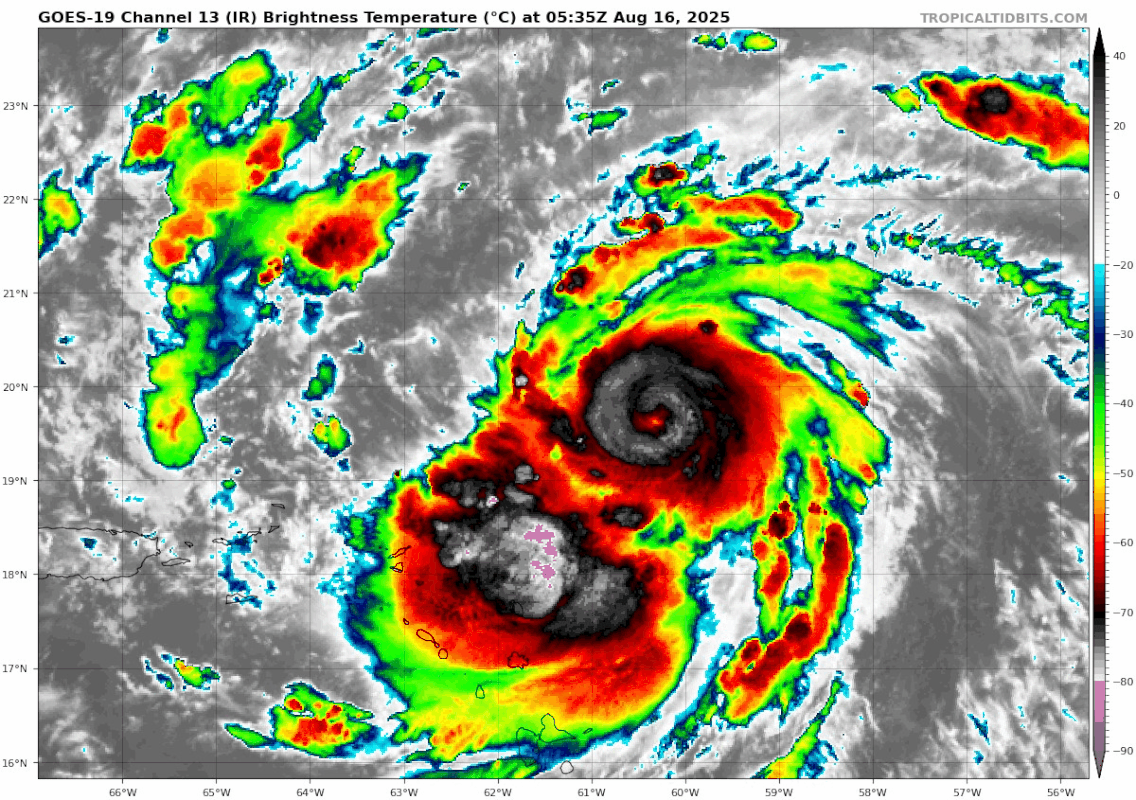
AL, 05, 2025081606, , BEST, 0, 196N, 604W, 90, 970, HU
Ninety knots roughly equates to 105 mph, But with a pressure of 970 mb I wouldn't be surprised if the next advisory has the winds at 110 mph. The likelihood of Cat3 intensity later today was mentioned in an earlier comment or two, but I think Cat4 by sometime this afternoon is a real possibility.
0 likes
Re: ATL: ERIN - Hurricane - Discussion
Holy cow I did not expect it to become a major this fast. Should be flirting with Cat 5 status later today assuming no major disruptions occur.
1 likes
Irene '11 Sandy '12 Hermine '16 5/15/2018 Derecho Fay '20 Isaias '20 Elsa '21 Henri '21 Ida '21
I am only a meteorology enthusiast who knows a decent amount about tropical cyclones. Look to the professional mets, the NHC, or your local weather office for the best information.
- Kingarabian
- S2K Supporter
- Posts: 16074
- Joined: Sat Aug 08, 2009 3:06 am
- Location: Honolulu, Hawaii
Re: ATL: ERIN - Hurricane - Discussion
Put on a show the last 24 hours. Very impressive.
1 likes
RIP Kobe Bryant
-
- S2K Supporter
- Posts: 7199
- Joined: Wed May 19, 2004 5:46 am
- Location: NE Fort Lauderdale
- Contact:
Re: ATL: ERIN - Hurricane - Discussion
Kingarabian wrote:Put on a show the last 24 hours. Very impressive.
The intensification modeling has been good the last 36 hours, the cant be discounted ICON continues to be left and this morning the center is well off to the south of the track, it all matters downstream especially at with these intensities, saw a 915 core off new foundland modeled, would be difficult that far north to get that deep.
1 likes
Re: ATL: ERIN - Hurricane - Discussion
946.9mb extrapolated and ~120 kt peak FL from NOAA2. Looks like we already have a Cat 4, or at the very least a high-end 3.
2 likes
Irene '11 Sandy '12 Hermine '16 5/15/2018 Derecho Fay '20 Isaias '20 Elsa '21 Henri '21 Ida '21
I am only a meteorology enthusiast who knows a decent amount about tropical cyclones. Look to the professional mets, the NHC, or your local weather office for the best information.
- weeniepatrol
- Category 5
- Posts: 1295
- Joined: Sat Aug 22, 2020 5:30 pm
- Location: WA State
Re: ATL: ERIN - Hurricane - Discussion
GCANE wrote:GCANE wrote:60 hrs out and 75% chance of a Cat4, 35% for Cat5.
Peaks around 8AM Monday north of Hispaniola.
Right about where the CoC and ULL, driving the poleward outflow channel, are at the same latitude.
https://rammb-data.cira.colostate.edu/tc_realtime/products/storms/2025al05/problcat/2025al05_problcat_202508150600.png
https://www.nhc.noaa.gov/storm_graphics/AT05/refresh/AL052025_5day_cone_no_line_and_wind+png/151736_5day_cone_no_line_and_wind.png
Forgot to mention that a straight due-north course induces a secondary Coriolis force which may strengthen Erin more than what the models are forecasting.
This is a little known effect and not built into the models.
Hmmm. I wonder if GFS has incorporated this secondary Coriolis effect.
Has Erin in the 930's from 25N to 35N when it is tracking due north.
1 likes
Re: RE: Re: ATL: ERIN - Hurricane - Discussion
Wow, yeah that pressure gradient is super tight and symmetrical. She's overachieving at the moment.aspen wrote:946.9mb extrapolated and ~120 kt peak FL from NOAA2. Looks like we already have a Cat 4.
3 likes
- cycloneye
- Admin
- Posts: 146094
- Age: 69
- Joined: Thu Oct 10, 2002 10:54 am
- Location: San Juan, Puerto Rico
Re: ATL: ERIN - Hurricane - Discussion
A very noticable jog to the west.


4 likes
Visit the Caribbean-Central America Weather Thread where you can find at first post web cams,radars
and observations from Caribbean basin members Click Here
Re: ATL: ERIN - Hurricane - Discussion
Erin is now a category 4 hurricane
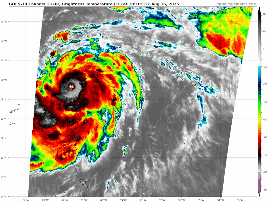
, looks like it'a gonna be one of those storms. Astonishing.

341
WTNT65 KNHC 160951
TCUAT5
Hurricane Erin Tropical Cyclone Update
NWS National Hurricane Center Miami FL AL052025
550 AM AST Sat Aug 16 2025
...NOAA HURRICANE HUNTERS FIND ERIN A DANGEROUS CATEGORY 4
HURRICANE...
The NOAA Hurricane Hunters are currently investigating Erin and on
the first pass through the hurricane they found that maximum
sustained winds have increased to 130 mph (215 km/h) with higher
gusts. This makes Erin a Category 4 hurricane on the
Saffir-Simpson Hurricane Wind Scale. The minimum pressure has
fallen to 948 mb (27.99 inches). The next intermediate advisory
will be issued at 800 AM AST (1200 UTC).
SUMMARY OF 550 AM AST...0950 UTC...INFORMATION
----------------------------------------------
LOCATION...19.6N 61.5W
ABOUT 150 MI...240 KM NE OF ANGUILLA
MAXIMUM SUSTAINED WINDS...130 MPH...215 KM/H
PRESENT MOVEMENT...WNW OR 285 DEGREES AT 20 MPH...31 KM/H
MINIMUM CENTRAL PRESSURE...948 MB...27.99 INCHES
$$
Forecaster Cangialosi/Gibbs/Kelly
4 likes
- weeniepatrol
- Category 5
- Posts: 1295
- Joined: Sat Aug 22, 2020 5:30 pm
- Location: WA State
Re: ATL: ERIN - Hurricane - Discussion
F. CLOSED
G. C7
G. C7
Pinhole eye
Additionally…
FREQUENT LIGHTNING
Last edited by weeniepatrol on Sat Aug 16, 2025 5:16 am, edited 1 time in total.
3 likes
Re: ATL: ERIN - Hurricane - Discussion
In the last 12 hours Erin has intensified from 70 kt to 115 kt and a 45 mb pressure drop. As far as I know this is pretty much unprecedented in the open MDR. Most ERIs take place in the WCar or Gulf (Wilma, Milton). Even Beryl only has a 30kt wind increase in 12 hours, while Erin has intensified by 45 kt in the same time period. She's gonna be one for the history books. Let's all hope that the models are right and this avoids all land.
Edit: the only hurricane I can think of that has exceeded Erin in terms of ERI in the open MDR is Lee which had a 50 kt increase in 12 hours. Even though that might also be beaten if Erin keeps going like this.
Last edited by kevin on Sat Aug 16, 2025 5:15 am, edited 2 times in total.
4 likes
Re: ATL: ERIN - Hurricane - Discussion
MIMIC-TPW showing Erin just starting to tap into the Amazon juice.
Still tracking into the anti-cyclone. Just about stacked now.
SAL has decreased significantly.
Just about a perfect 355K PV ring around this creating nearly ideal outflow in all quads.
Very likely will get an EWRC sometime in the next 24 hrs.
Still tracking into the anti-cyclone. Just about stacked now.
SAL has decreased significantly.
Just about a perfect 355K PV ring around this creating nearly ideal outflow in all quads.
Very likely will get an EWRC sometime in the next 24 hrs.
0 likes
-
- S2K Supporter
- Posts: 7199
- Joined: Wed May 19, 2004 5:46 am
- Location: NE Fort Lauderdale
- Contact:
Re: ATL: ERIN - Hurricane - Discussion
That northerly flow hitting the PR mountains, looks like a very efficient setup for a flood.
0 likes
- weeniepatrol
- Category 5
- Posts: 1295
- Joined: Sat Aug 22, 2020 5:30 pm
- Location: WA State
Re: ATL: ERIN - Hurricane - Discussion
Last edited by weeniepatrol on Sat Aug 16, 2025 5:28 am, edited 4 times in total.
6 likes
Re: ATL: ERIN - Hurricane - Discussion
Kermit's fix has Erin about 16nm south of forecast track.
0 likes
- Hypercane_Kyle
- Category 5
- Posts: 3376
- Joined: Sat Mar 07, 2015 7:58 pm
- Location: Cape Canaveral, FL
Re: ATL: ERIN - Hurricane - Discussion
Reminds me a bit of Maria. Huge relief this one is missing major landmasses.


3 likes
My posts are my own personal opinion, defer to the National Hurricane Center (NHC) and other NOAA products for decision making during hurricane season.
Return to “Active Storms/Invests - Atlantic/EastPAC/CentralPAC/MED”
Who is online
Users browsing this forum: BobHarlem and 136 guests