NATL: MELISSA - Aftermath - Discussion
Moderator: S2k Moderators
-
Hypercane_Kyle

- Category 5

- Posts: 3465
- Joined: Sat Mar 07, 2015 7:58 pm
- Location: Cape Canaveral, FL
Re: NATL: MELISSA - Tropical Storm - Discussion
Melissa finally has an inner core. Rapid intensification is about to begin.
1 likes
My posts are my own personal opinion, defer to the National Hurricane Center (NHC) and other NOAA products for decision making during hurricane season.


Re: NATL: MELISSA - Tropical Storm - Discussion
Soo, after perusing the comments as best as I could to see if anyone had already posted Dr. Cowan's latest update and finding no such post, here it is:
Link: https://youtu.be/0UcuBGeplGU
Link: https://youtu.be/0UcuBGeplGU
5 likes
-
CrazyC83
- Professional-Met

- Posts: 34316
- Joined: Tue Mar 07, 2006 11:57 pm
- Location: Deep South, for the first time!
Re: NATL: MELISSA - Tropical Storm - Discussion
Hypercane_Kyle wrote:Melissa finally has an inner core. Rapid intensification is about to begin.
I'm thinking tomorrow is the day it goes up, up and away.
0 likes
Re: NATL: MELISSA - Tropical Storm - Discussion
Here's a collection of live video streams from Jamaica cameras
https://www.youtube.com/@SeeJamaica/streams
Folks are definitely busy there, and sometimes one of the cameras shows a supermarket (that's slammed). Another is a stream from the 200+ year old one lane flat bridge in Bog Walk over a river (probably will flood).
https://www.youtube.com/@SeeJamaica/streams
Folks are definitely busy there, and sometimes one of the cameras shows a supermarket (that's slammed). Another is a stream from the 200+ year old one lane flat bridge in Bog Walk over a river (probably will flood).
3 likes

Re: NATL: MELISSA - Tropical Storm - Discussion
MarioProtVI wrote:DRCL (which NHC 95% of the time follows) has a 135 kt point at 72 hours, and then 120 kt just inland of Jamaica at 96. This all but screams they’re going to heavily allude to the fact that Melissa will likely reach Cat 5 before making landfall in Jamaica. Probably “conservative” as well, because that’s a whole day in between borderline C5 and landfall.
Yep, they went with a 135 kt peak ahead of landfall for 5pm.
They also went with a slightly higher current intensity of 55 kt/995 mbar.
1 likes
Irene '11 Sandy '12 Hermine '16 5/15/2018 Derecho Fay '20 Isaias '20 Elsa '21 Henri '21 Ida '21
I am only a meteorology enthusiast who knows a decent amount about tropical cyclones. Look to the professional mets, the NHC, or your local weather office for the best information.
I am only a meteorology enthusiast who knows a decent amount about tropical cyclones. Look to the professional mets, the NHC, or your local weather office for the best information.
Re: NATL: MELISSA - Tropical Storm - Discussion
Almost last visibles of the day
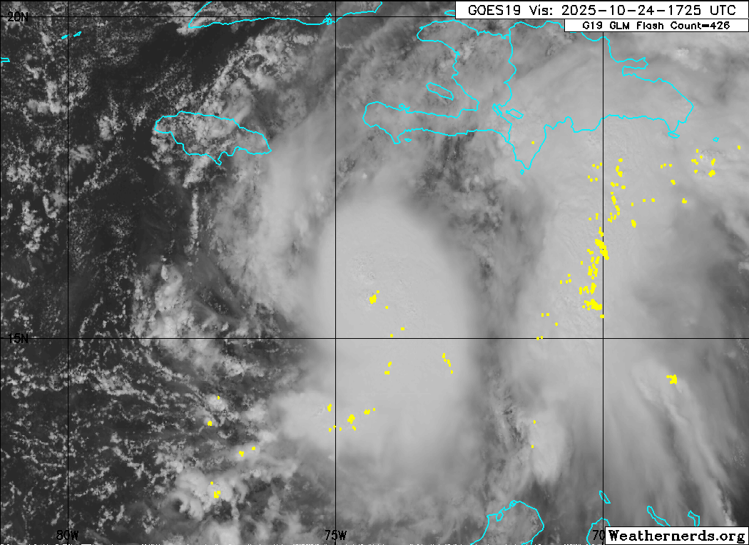
Last edited by BobHarlem on Fri Oct 24, 2025 3:58 pm, edited 2 times in total.
3 likes
-
Iceresistance

- Category 5
- Posts: 9605
- Age: 22
- Joined: Sat Oct 10, 2020 9:45 am
- Location: Tecumseh, OK/Norman, OK
Re: NATL: MELISSA - Tropical Storm - Discussion
I'm starting to get scared now, NHC has 140 mph over Jamaica on the cone
2 likes
Bill 2015 & Beta 2020
Winter 2020-2021
All observations are in Tecumseh, OK unless otherwise noted.
Winter posts are focused mainly for Oklahoma & Texas.
Take any of my forecasts with a grain of salt, refer to the NWS, SPC, and NHC for official information
Never say Never with weather! Because ANYTHING is possible!
Winter 2020-2021
All observations are in Tecumseh, OK unless otherwise noted.
Winter posts are focused mainly for Oklahoma & Texas.
Take any of my forecasts with a grain of salt, refer to the NWS, SPC, and NHC for official information
Never say Never with weather! Because ANYTHING is possible!
Re: NATL: MELISSA - Tropical Storm - Discussion
The forecast now shows a 135 kt peak in 60 h, and there is a distinct possibility that Melissa could become a Category 5 hurricane during this time period. In fact, the latest 12z Google DeepMind ensemble distribution shows the majority of its members reaching this lofty intensity.

6 likes
Irene '11 Sandy '12 Hermine '16 5/15/2018 Derecho Fay '20 Isaias '20 Elsa '21 Henri '21 Ida '21
I am only a meteorology enthusiast who knows a decent amount about tropical cyclones. Look to the professional mets, the NHC, or your local weather office for the best information.
I am only a meteorology enthusiast who knows a decent amount about tropical cyclones. Look to the professional mets, the NHC, or your local weather office for the best information.
-
Hypercane_Kyle
- Category 5
- Posts: 3465
- Joined: Sat Mar 07, 2015 7:58 pm
- Location: Cape Canaveral, FL
Re: NATL: MELISSA - Tropical Storm - Discussion
Iceresistance wrote:I'm starting to get scared now, NHC has 140 mph over Jamaica on the cone
The NHC forecast is as close to as them saying "we think Melissa will hit Jamacia as a Category 5" as they will say for a system for that's only a tropical storm.
1 likes
My posts are my own personal opinion, defer to the National Hurricane Center (NHC) and other NOAA products for decision making during hurricane season.

Re: NATL: MELISSA - Tropical Storm - Discussion
Chances are increasing for a historic cat 4/5 landfall on Jamaica. Let's hope Melissa somehow still misses Jamaica, but I'm starting to doubt it now: the center relocation has resolved one of the big short-term uncertainties about Melissa's behavior. She looks primed for RI so if she were to hit Jamaica perhaps the only savior could be a last-minute EWRC still in progress during landfall.
I'm not gonna act hypocritical, of course I'll also be amazed if Melissa becomes a generational storm in terms of intensity. These extraordinary showcases of nature are the reason many of us track storms. But let's all also remember that there are millions of people who are in a very dangerous situation.
I'm not gonna act hypocritical, of course I'll also be amazed if Melissa becomes a generational storm in terms of intensity. These extraordinary showcases of nature are the reason many of us track storms. But let's all also remember that there are millions of people who are in a very dangerous situation.
6 likes

Re: NATL: MELISSA - Tropical Storm - Discussion
BobHarlem wrote:Here's a collection of live video streams from Jamaica cameras
https://www.youtube.com/@SeeJamaica/streams
Folks are definitely busy there, and sometimes one of the cameras shows a supermarket (that's slammed). Another is a stream from the 200+ year old one lane flat bridge in Bog Walk over a river (probably will flood).
I guess the good news might be if the track shifts far enough south Jamaica might stay out of the core winds for a couple days. Just a foot or two of rain to soften up the soil so the tree roots won't hold. Then with less land interaction a stronger Melissa will be ready to make a faster pass NE over the island.
Its too easy for complacency to set in with the 5 day wait before the hook NE so that might be why the Governor is holding off on the final evacuation orders.
1 likes

Re: NATL: MELISSA - Tropical Storm - Discussion
Hypercane_Kyle wrote:Iceresistance wrote:I'm starting to get scared now, NHC has 140 mph over Jamaica on the cone
The NHC forecast is as close to as them saying "we think Melissa will hit Jamacia as a Category 5" as they will say for a system for that's only a tropical storm.
Even when just going by what's explicitly in the forecast, it also has Melissa at 135 kts for 12 hours (60-72h), and the next forecast point 12 hours later (96h) is already inland over Jamaica (albeit just barely). Melissa can adhere to this forecast precisely while still peaking at Cat 5, or even landfallint in Jamaica as such, during any of this 24-hour period.
Edit: Weakening just before landfall is also not always a good thing. Maria's last-minute EWRC prior to hitting Puerto Rico, while avoiding a Cat 5 landfall for meteorological records, made its impacts arguably much worse.
4 likes
TC naming lists: retirements and intensity
Most aggressive Advisory #1's in North Atlantic (cr. kevin for starting the list)
Most aggressive Advisory #1's in North Atlantic (cr. kevin for starting the list)
Re: NATL: MELISSA - Tropical Storm - Discussion

6 likes
TC naming lists: retirements and intensity
Most aggressive Advisory #1's in North Atlantic (cr. kevin for starting the list)
Most aggressive Advisory #1's in North Atlantic (cr. kevin for starting the list)
NATL: MELISSA - Tropical Storm - Discussion
Strengthening Dvorak...Increase in spiral shape...
3 likes
-
Iceresistance
- Category 5
- Posts: 9605
- Age: 22
- Joined: Sat Oct 10, 2020 9:45 am
- Location: Tecumseh, OK/Norman, OK
Re: NATL: MELISSA - Tropical Storm - Discussion
3 likes
Bill 2015 & Beta 2020
Winter 2020-2021
All observations are in Tecumseh, OK unless otherwise noted.
Winter posts are focused mainly for Oklahoma & Texas.
Take any of my forecasts with a grain of salt, refer to the NWS, SPC, and NHC for official information
Never say Never with weather! Because ANYTHING is possible!
Winter 2020-2021
All observations are in Tecumseh, OK unless otherwise noted.
Winter posts are focused mainly for Oklahoma & Texas.
Take any of my forecasts with a grain of salt, refer to the NWS, SPC, and NHC for official information
Never say Never with weather! Because ANYTHING is possible!
Re: NATL: MELISSA - Tropical Storm - Discussion
https://x.com/WeathermanAAA_/status/1981831269282619830
(Note that I believe this record only considers systems whose initial intensity on the advisory was exact 55 kt, not even 50 or 60, etc.)
It's also worth noting that this projection ties for one of the most aggressive intensification rates ever issued for a 55kt system, reaching the record maximum percentile for hours 12-48.
(Note that I believe this record only considers systems whose initial intensity on the advisory was exact 55 kt, not even 50 or 60, etc.)
5 likes
TC naming lists: retirements and intensity
Most aggressive Advisory #1's in North Atlantic (cr. kevin for starting the list)
Most aggressive Advisory #1's in North Atlantic (cr. kevin for starting the list)
-
Hurricane Mike
- Category 2

- Posts: 675
- Joined: Tue Apr 10, 2018 7:44 am
Re: NATL: MELISSA - Tropical Storm - Discussion
5:30pm video on Melissa
https://www.youtube.com/watch?v=o9Z-otdemj8
https://www.youtube.com/watch?v=o9Z-otdemj8
2 likes
-
ScottNAtlanta

- Category 5
- Posts: 2535
- Joined: Sat May 25, 2013 3:11 pm
- Location: Atlanta, GA
Re: NATL: MELISSA - Tropical Storm - Discussion
I've decided that we are moving the curse of the "I" storm to the "M" storms
12 likes
The posts in this forum are NOT official forecast and should not be used as such. They are just the opinion of the poster and may or may not be backed by sound meteorological data. They are NOT endorsed by any professional institution or storm2k.org. For official information, please refer to the NHC and NWS products.
-
Iceresistance
- Category 5
- Posts: 9605
- Age: 22
- Joined: Sat Oct 10, 2020 9:45 am
- Location: Tecumseh, OK/Norman, OK
Re: NATL: MELISSA - Tropical Storm - Discussion
6 likes
Bill 2015 & Beta 2020
Winter 2020-2021
All observations are in Tecumseh, OK unless otherwise noted.
Winter posts are focused mainly for Oklahoma & Texas.
Take any of my forecasts with a grain of salt, refer to the NWS, SPC, and NHC for official information
Never say Never with weather! Because ANYTHING is possible!
Winter 2020-2021
All observations are in Tecumseh, OK unless otherwise noted.
Winter posts are focused mainly for Oklahoma & Texas.
Take any of my forecasts with a grain of salt, refer to the NWS, SPC, and NHC for official information
Never say Never with weather! Because ANYTHING is possible!
Who is online
Users browsing this forum: Google Adsense [Bot] and 56 guests