Texas Spring 2026
Moderator: S2k Moderators
Forum rules

The posts in this forum are NOT official forecast and should not be used as such. They are just the opinion of the poster and may or may not be backed by sound meteorological data. They are NOT endorsed by any professional institution or STORM2K.
-
HockeyTx82
- S2K Supporter

- Posts: 2797
- Joined: Tue Oct 27, 2009 11:17 am
- Location: Ponder, TX
Re: Texas Spring 2026
1.08" IMBY last night.
0 likes
Don't hold me accountable for anything I post on this forum. Leave the real forecasting up to the professionals.
Location: Ponder, TX (all observation posts are this location unless otherwise noted)
Location: Ponder, TX (all observation posts are this location unless otherwise noted)


Re: Texas Spring 2026
In the world of ENSO, El Nino is starting to take hold with low frequency signal in the tropics. Pretty evident with the MJO looking like it will set over the Pacific again and again. It's coming, and it's going to control everything weather soon for us.

2 likes
The above post and any post by Ntxw is NOT an official forecast and should not be used as such. It is just the opinion of the poster and may or may not be backed by sound meteorological data. It is NOT endorsed by any professional institution including Storm2k. For official information, please refer to NWS products.
Help support Storm2K!
-
txtwister78

- Category 5

- Posts: 2204
- Joined: Wed Jan 30, 2019 12:56 pm
- Location: San Antonio
Re: Texas Spring 2026
wxman22 wrote:txtwister78 wrote:wxman22 wrote:
The Enhanced Risk looks to be verifying to me the whole line is severe warned.What were you expecting? Tornado warning issued now also We have warnings on top of warnings here.Right now the storm chaser for one of the local news station is reporting winds of 75 mph live.
And you don't need a lot of instability up here due to the large amount of shear we get. It meets enhanced risk criteria to me. And enhanced risk is more about quantity of severe storms ( Numerous severe thunderstorms) and that is verifying. We weren’t talking about a moderate risk outbreak lol. I do agree with you though on Friday being interesting.
https://i.postimg.cc/7Zk8zBsv/IMG-0729.png
https://i.postimg.cc/43H6T5gS/IMG-0730.gif
Well for one, I wasn't talking about the enhanced risk (yes I know what it means) or coming into today with an "expectation" of anything other than parts of the state getting some much needed rain. This was never a day that screamed "big severe weather outbreak" hence my instability comment (lol). I was reacting to the Tornado Watch issued by SPC and basically saying good thing things aren't going in that direction (radar/real-time wise).
The instability comment wasn't meant to suggest there wouldn't be severe weather today. Of course instability alone doesn't negate the prospect of severe weather (obviously) but it certainly can impact the range storms have to work with dynamically when parameters are higher than they were today as we saw?
Thus far we've had one very large hail report and one high wind report and no tornadoes. So yeah, I'd say that's a pretty good indicator again as severe weather days can go in Texas and witb a Tornado Watch posted of a "more bark than bite" end result and btw that's also why I said "that's a good thing". Take that comment as a positive one my friend. That's all. More to track going forward.
Boo! I want a tornado LOL joking of course.Sorry if I came across “gruff” last night.
No worries and unfortunately they're too many people on the web/social media world these days not joking when it comes to the Tornado aspect. That's so odd/cringe to me (definitely not like wanting/hoping for snow Lol)?Anyway don't get me started on that one...lol
Just glad folks are cashing in on some much needed rain up north. Much more to come across the state from the looks of things.
1 likes

-
Iceresistance

- Category 5
- Posts: 9591
- Age: 22
- Joined: Sat Oct 10, 2020 9:45 am
- Location: Tecumseh, OK/Norman, OK
Re: Texas Spring 2026
HockeyTx82 wrote:1.08" IMBY last night.
I had around an inch as well, rain gauge said .6, but the wind was crazy
0 likes
Bill 2015 & Beta 2020
Winter 2020-2021
All observations are in Tecumseh, OK unless otherwise noted.
Winter posts are focused mainly for Oklahoma & Texas.
Take any of my forecasts with a grain of salt, refer to the NWS, SPC, and NHC for official information
Never say Never with weather! Because ANYTHING is possible!
Winter 2020-2021
All observations are in Tecumseh, OK unless otherwise noted.
Winter posts are focused mainly for Oklahoma & Texas.
Take any of my forecasts with a grain of salt, refer to the NWS, SPC, and NHC for official information
Never say Never with weather! Because ANYTHING is possible!
Re: Texas Spring 2026
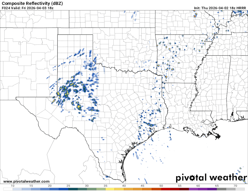
wxman22 wrote:The HRRR looks very wet tomorrow evening/night.
https://i.postimg.cc/j2r37xNQ/floop-hrrr-2026040218-refcmp-us-sc.gif
I noticed the Euro since a few runs ago was sending 2 rounds of linear activity, beautiful! It's been a beautiful day today, something about a warm day after rain everything is lush. I'm ready for things to be different with many opportunities for rain.
About this time next week the flow will be directly out of the EPAC with a highway of mid level moisture streaming in from the Pacific. The pineapple express looks like it may be arriving!
Excessive rainfall may become a concern.

1 likes
The above post and any post by Ntxw is NOT an official forecast and should not be used as such. It is just the opinion of the poster and may or may not be backed by sound meteorological data. It is NOT endorsed by any professional institution including Storm2k. For official information, please refer to NWS products.
Help support Storm2K!
Help support Storm2K!
-
HockeyTx82
- S2K Supporter
- Posts: 2797
- Joined: Tue Oct 27, 2009 11:17 am
- Location: Ponder, TX
Re: Texas Spring 2026
Ntxw wrote:wxman22 wrote:The HRRR looks very wet tomorrow evening/night.
https://i.postimg.cc/j2r37xNQ/floop-hrrr-2026040218-refcmp-us-sc.gif
I noticed the Euro since a few runs ago was sending 2 rounds of linear activity, beautiful! It's been a beautiful day today, something about a warm day after rain everything is lush. I'm ready for things to be different with many opportunities for rain.
About this time next week the flow will be directly out of the EPAC with a highway of mid level moisture streaming in from the Pacific. The pineapple express looks like it may be arriving!
Excessive rainfall may become a concern.
https://i.imgur.com/MfyA2KN.png
Well that might put a dent into camping that weekend at Lake Bridgeport.....
0 likes
Don't hold me accountable for anything I post on this forum. Leave the real forecasting up to the professionals.
Location: Ponder, TX (all observation posts are this location unless otherwise noted)
Location: Ponder, TX (all observation posts are this location unless otherwise noted)
Return to “USA & Caribbean Weather”
Who is online
Users browsing this forum: HockeyTx82 and 162 guests