ATL: Tropical Depression Fay
Moderator: S2k Moderators

Re: ATL: Tropical Storm Fay
It is interesting, most storms don't come out the other side of Hispanola a stronger storm...
0 likes
Re: ATL: Tropical Storm Fay
LCfromFL wrote:Nervous mama here...my daughter is leaving for FSU (Tallahassee) tomorrow. Sorority Recruitment (Rush Week) starts on Monday - my daughter is rushing. She'll be staying at my aunt's house in northern Tallahassee until she is able to move into her apartment on Wednesday (yeah the timing really bites). I'd assume that some of the FSU buildings are designated as shelters? Obviously she won't stay if this thing turns major and continues on that course towards Tallahassee...
As an FSU grad who went through a couple of storms up there, I can tell you she will be just fine. FSU does have some pretty strong buildings on campus and does have an emergency plan for these scenarios. Some of those buildings on campus are like bomb shelters and unfortunately that's why they look ugly. Send her away, besides you can't let her miss out on her first hurricane party! right?
0 likes
-
Blown Away

- S2K Supporter

- Posts: 10253
- Joined: Wed May 26, 2004 6:17 am
Re: ATL: Tropical Storm Fay
Fay looks like she is moving slower than last night, I know the NHC says 14 mph, it just doesn't look like that on satellite.
http://www.ssd.noaa.gov/goes/flt/t1/loop-vis.html
http://www.ssd.noaa.gov/goes/flt/t1/loop-vis.html
Last edited by Blown Away on Sat Aug 16, 2008 7:35 am, edited 1 time in total.
0 likes

Re: ATL: Tropical Storm Fay
I agree. Since it's not that well developed, it has the luxury of sort of adapting to the topography. When the system is stacked and the center crosses over a 10000ft mountain, that is definitely very disruptive. But if it's not stacked well, I think the LLC can just end up establishing itself away from the unfavorable terrain. It certainly won't help it organize, but I think it takes less of a toll on it when it's not well formed.
Lowpressure wrote:Fay has been difficult to follow to this point. I still think the final LLC has yet to be determined, but that thunderstrom cluster of the southern coast is very impressive, even considering the sun angle. Upper air dynamics and pattern look like a much stronger storm. Most storms seem to have a better LLC and wait until the upper dynamics come into place. Fay is just the opposite. It will be very interesting to follow this with such dynamics in place that mountain ranges did not hinder the system. Maybe no real LLC is why is did so well over DR, nothing to really disrupt.
0 likes
-
storms in NC

- S2K Supporter
- Posts: 2338
- Joined: Thu Jul 28, 2005 2:58 pm
- Location: Wallace,NC 40 miles NE of Wilm
- Contact:
Re: ATL: Tropical Storm Fay
Lowpressure wrote:Fay has been difficult to follow to this point. I still think the final LLC has yet to be determined, but that thunderstrom cluster of the southern coast is very impressive, even considering the sun angle. Upper air dynamics and pattern look like a much stronger storm. Most storms seem to have a better LLC and wait until the upper dynamics come into place. Fay is just the opposite. It will be very interesting to follow this with such dynamics in place that mountain ranges did not hinder the system. Maybe no real LLC is why is did so well over DR, nothing to really disrupt.
I think you are right. I have been looking and watching hurricanes for a long time. I have never had trouble finding the center. I didn't see it yesterday and I don't see it today. I do see and have seen the middle low. That is it.
A small side note. I think you will start to see fay start to turn to the north sooner than most think. So south fl would need to watch this.
Last edited by storms in NC on Sat Aug 16, 2008 7:39 am, edited 1 time in total.
0 likes
-
cycloneye

- Admin

- Posts: 149372
- Age: 69
- Joined: Thu Oct 10, 2002 10:54 am
- Location: San Juan, Puerto Rico
Re: ATL: Tropical Storm Fay
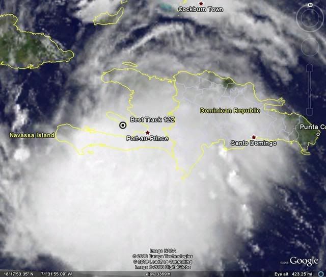
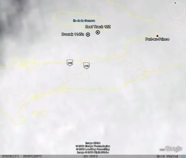
12:00 UTC Best Track:
AL, 06, 2008081612, , BEST, 0, 187N, 729W, 40, 1008, TS, 34, NEQ, 90, 60, 0, 75,
ftp://ftp.tpc.ncep.noaa.gov/atcf/tcweb/
AL, 06, 2008081612, , BEST, 0, 187N, 729W, 40, 1008, TS, 34, NEQ, 90, 60, 0, 75,
ftp://ftp.tpc.ncep.noaa.gov/atcf/tcweb/
0 likes

Re:
gatorcane wrote::uarrow:
Undoubtedly east coast sea breezes will kick in later on today so it may just be a macro-climate influence.
or maybe the mid-level winds will work down to the surface and create more ESE winds
Last night there were absolutely no winds down here, dead warm humid air. That was kind of odd.
0 likes

Re:
gatorcane wrote:Well the heights across FL must be above the low-levels. I'm checking out observations across the SE Coast of FL and the winds are WEAK. That almost always indicates weak ridging around Southern FL. If storms pass us by to the south, almost always you see winds out of the E or SE much strong than that. I will monitor these winds over the next couple of days
NAPLES PTCLDY 77 74 90 NE3 30.01R
W PALM BEACH PTCLDY 77 71 82 CALM 30.00S
FT LAUDER-EXEC CLEAR 78 75 90 CALM 30.01R
FT LAUDERDALE PTCLDY 81 73 76 NW3 30.00S
POMPANO BEACH CLEAR 78 76 93 CALM 30.01R
OPA LOCKA CLEAR 79 75 87 N5 30.01R
MIAMI PTCLDY 81 75 82 VRB3 30.01R
WEST KENDALL PTCLDY 74 74 100 CALM 30.01R
HOMESTEAD PTCLDY 77 74 90 CALM 30.01R FOG
Currently, the ML subtropical ridge extending into southern FL is very weak over the state, though it is stronger in the central and eastern Bahamas on eastward.
0 likes
-
canetracker

- S2K Supporter
- Posts: 751
- Age: 63
- Joined: Wed Jul 27, 2005 8:49 pm
- Location: Suburbia New Orleans...Harahan, LA
Re: ATL: Tropical Storm Fay
ronjon wrote:I'm wondering if the MLC is offshore south of the Haitian peninsula and the LLC futher north. If so, still not co-located and probably won't strengthen significantly until they do.
I am wondering that as well. The LLC could be around the NHC estimates and the MLC could be south of Hispaniola.
0 likes


-
cycloneye
- Admin
- Posts: 149372
- Age: 69
- Joined: Thu Oct 10, 2002 10:54 am
- Location: San Juan, Puerto Rico
Re: ATL: Tropical Storm Fay
HURAKAN,put the dvorak position: Its in the water.
16/1145 UTC 18.7N 73.0W T2.5/2.5 FAY -- Atlantic Ocean
http://www.ssd.noaa.gov/PS/TROP/positions.html
16/1145 UTC 18.7N 73.0W T2.5/2.5 FAY -- Atlantic Ocean
http://www.ssd.noaa.gov/PS/TROP/positions.html
0 likes

-
Weatherfreak14

- Category 5

- Posts: 1381
- Joined: Sat Sep 24, 2005 3:40 pm
- Location: Beaufort, SC
- Contact:
Re: ATL: Tropical Storm Fay
There is an ULL on the Westeren side of cuba, it looks like its staying in place... It was in the exact spot about 11pm last night, this could turn fay north very soon since fay is weak and will start to feel it.
0 likes

-
DESTRUCTION5

- Category 5
- Posts: 4430
- Age: 44
- Joined: Wed Sep 03, 2003 11:25 am
- Location: Stuart, FL
Re: Re:
CronkPSU wrote:KatDaddy wrote:That is S of all guidance models. I would expect a shift W with the next model outputs
why?
Looks right where the NHC wants it to be to me?
0 likes
-
Blown Away
- S2K Supporter
- Posts: 10253
- Joined: Wed May 26, 2004 6:17 am
Re:
KatDaddy wrote:That is S of all guidance models. I would expect a shift W with the next model outputs
Not really, it's N of the GFS and a little S of the GFDL, like 10 miles.
0 likes
Who is online
Users browsing this forum: No registered users and 29 guests