ATL: TROPICAL LOW ex-FRED (ex-07L)

Moderator: S2k Moderators

Message
Author
User avatar
brunota2003
S2K Supporter
S2K Supporter
Posts: 9476
Age: 34
Joined: Sat Jul 30, 2005 9:56 pm
Location: Stanton, KY...formerly Havelock, NC
Contact:

Re: Re:

#501 Postby brunota2003 » Wed Sep 09, 2009 5:40 pm

caribepr wrote:"AST is the same as EDT...as EST would be the same time as CDT"

Just a note...AST, Atlantic Standard Time, is only the same as EST, Eastern Standard Time, when daylight savings time is not in effect, because we do not have daylight savings time in the AST zone, so there is an hour's difference then. Central Daylight Time...too far west for me to think about, but it's not the same as EST..

Yes it is...right now it is 6:40 EDT, which is 5:40 CDT...if you subtract the hour from EDT to get EST, you have 5:40...Granted, you'll never see it written in EST in an advisory, unless daylight savings time is over...you'll always see 5 pm EDT, or 4 pm Central (CDT).

But I dont think it really matters :lol: as long as it is clear that 5 pm EDT is the same as 5 pm AST.
0 likes   

leanne_uk
Tropical Storm
Tropical Storm
Posts: 214
Age: 42
Joined: Fri Sep 04, 2009 4:38 pm
Location: Loughborough countryside, Leicestershire, UK

#502 Postby leanne_uk » Wed Sep 09, 2009 5:50 pm

Am i right in thinking that the sustained winds have increased a little since the last advisory?

Not sure as I am keeping track on the mobile and its a pain webpage flicking lol.
0 likes   

User avatar
brunota2003
S2K Supporter
S2K Supporter
Posts: 9476
Age: 34
Joined: Sat Jul 30, 2005 9:56 pm
Location: Stanton, KY...formerly Havelock, NC
Contact:

Re:

#503 Postby brunota2003 » Wed Sep 09, 2009 5:54 pm

leanne_uk wrote:Am i right in thinking that the sustained winds have increased a little since the last advisory?

Not sure as I am keeping track on the mobile and its a pain webpage flicking lol.

I dont think they've increased quite yet...the ERC has not quite finished, so I'd expect the winds are still around 115 mph...I wonder why ERC's vary so much though? I've seen hurricanes drop two or three categories because of an ERC, and then this one only dropped 5 mph, from 120 to 115 mph.
0 likes   

Derek Ortt

#504 Postby Derek Ortt » Wed Sep 09, 2009 6:07 pm

I dont think this is weakening due to an EWRC

MM5 and ARW showed this evolution (though starting tomorrow)... this is getting sheared already

could be dissipated in 3 days even
0 likes   

ozonepete
Professional-Met
Professional-Met
Posts: 4743
Joined: Mon Sep 07, 2009 3:23 pm
Location: From Ozone Park, NYC / Now in Brooklyn, NY

Re: Re:

#505 Postby ozonepete » Wed Sep 09, 2009 6:07 pm

brunota2003 wrote:
leanne_uk wrote:Am i right in thinking that the sustained winds have increased a little since the last advisory?

Not sure as I am keeping track on the mobile and its a pain webpage flicking lol.

I dont think they've increased quite yet...the ERC has not quite finished, so I'd expect the winds are still around 115 mph...I wonder why ERC's vary so much though? I've seen hurricanes drop two or three categories because of an ERC, and then this one only dropped 5 mph, from 120 to 115 mph.


They vary because of the other factors involved: mid-level dry air, shear and SSTs are the most important. If these don't change much, the ERC can be pretty rapid and "efficient", so that little wind energy is lost. If any or all of those other factors get involved, the ERC can cause a lot of energy loss as the thunderstorms in the newly developing eyewall get disrupted too much. On top of that, if any of those factors change during the whole process, the tropical cyclone can regain either all of its strength and then go on to become stronger or it may never regain any of its strength or weaken. Fred here may be a very good example. Right now it's still got all three factors just mentioned going for it, which is probably why it didn't weaken very much. But there is some moderately dry air to its west right now and southwesterly shear is getting close from the west also. As it's just completing its ERC, if any of that dry air gets pulled into its circulation over the next few hours, it will cause some of those Tstorms to ingest the dry air which will cause them to collapse. As they collapse they'll bring cool air down to the surface, which in turn will get ingested into the other thunderstorms' updrafts, and they will weaken also. That would cause a very efficient ERC to get "wasted" and be followed by a weakening. You can see how this gets very complicated and how many different scenarios might arise.
0 likes   

Aric Dunn
Category 5
Category 5
Posts: 21238
Age: 42
Joined: Sun Sep 19, 2004 9:58 pm
Location: Ready for the Chase.
Contact:

#506 Postby Aric Dunn » Wed Sep 09, 2009 6:14 pm

I love the models This year.....never can be consistent..
0 likes   

leanne_uk
Tropical Storm
Tropical Storm
Posts: 214
Age: 42
Joined: Fri Sep 04, 2009 4:38 pm
Location: Loughborough countryside, Leicestershire, UK

Re: Re:

#507 Postby leanne_uk » Wed Sep 09, 2009 6:24 pm

ozonepete wrote:
brunota2003 wrote:
leanne_uk wrote:Am i right in thinking that the sustained winds have increased a little since the last advisory?

Not sure as I am keeping track on the mobile and its a pain webpage flicking lol.

I dont think they've increased quite yet...the ERC has not quite finished, so I'd expect the winds are still around 115 mph...I wonder why ERC's vary so much though? I've seen hurricanes drop two or three categories because of an ERC, and then this one only dropped 5 mph, from 120 to 115 mph.


They vary because of the other factors involved: mid-level dry air, shear and SSTs are the most important. If these don't change much, the ERC can be pretty rapid and "efficient", so that little wind energy is lost. If any or all of those other factors get involved, the ERC can cause a lot of energy loss as the thunderstorms in the newly developing eyewall get disrupted too much. On top of that, if any of those factors change during the whole process, the tropical cyclone can regain either all of its strength and then go on to become stronger or it may never regain any of its strength or weaken. Fred here may be a very good example. Right now it's still got all three factors just mentioned going for it, which is probably why it didn't weaken very much. But there is some moderately dry air to its west right now and southwesterly shear is getting close from the west also. As it's just completing its ERC, if any of that dry air gets pulled into its circulation over the next few hours, it will cause some of those Tstorms to ingest the dry air which will cause them to collapse. As they collapse they'll bring cool air down to the surface, which in turn will get ingested into the other thunderstorms' updrafts, and they will weaken also. That would cause a very efficient ERC to get "wasted" and be followed by a weakening. You can see how this gets very complicated and how many different scenarios might arise.


So we are just on a wait and see right now as to what will become of our lovely Fred.
I however have to get some sleep so look forward to the morning to see whats been happening :)

Thanks for explaining all that to me too its helped a great deal :)
0 likes   

ozonepete
Professional-Met
Professional-Met
Posts: 4743
Joined: Mon Sep 07, 2009 3:23 pm
Location: From Ozone Park, NYC / Now in Brooklyn, NY

Re: ATL: HURRICANE FRED (07L)

#508 Postby ozonepete » Wed Sep 09, 2009 6:45 pm

:uarrow: You're welcome. Fred will still be there tomorrow. :)
0 likes   

User avatar
somethingfunny
ChatStaff
ChatStaff
Posts: 3926
Age: 37
Joined: Thu May 31, 2007 10:30 pm
Location: McKinney, Texas

Re: Re:

#509 Postby somethingfunny » Wed Sep 09, 2009 6:58 pm

brunota2003 wrote:
leanne_uk wrote:Am i right in thinking that the sustained winds have increased a little since the last advisory?

Not sure as I am keeping track on the mobile and its a pain webpage flicking lol.

I dont think they've increased quite yet...the ERC has not quite finished, so I'd expect the winds are still around 115 mph...I wonder why ERC's vary so much though? I've seen hurricanes drop two or three categories because of an ERC, and then this one only dropped 5 mph, from 120 to 115 mph.


I sure hope the Cape Verde Islands don't set their clocks to AST, because if that were the case they'd have sunrise at 3am and sunset at 3pm. It's odd to see Fred's visible floater come back up when it's only an hour or two past midnight here in Texas.

What a beautiful treat Fred has become. Right? (said Fred)....he's too sexy for his shear! Not really... when storms spin up very quickly they have a tendency to spin down just as fast and conditions look very hostile ahead. At this point, Fred doesn't even appear to be a threat to the Azores or Canaries...but it will still bear watching. Do the longer range models show this being picked up by an extratropical system and impacting Europe, or is Fred destined to just meander around before dissipating near 35W/25N?
0 likes   

User avatar
somethingfunny
ChatStaff
ChatStaff
Posts: 3926
Age: 37
Joined: Thu May 31, 2007 10:30 pm
Location: McKinney, Texas

Re: ATL: HURRICANE FRED (07L) - Computer Models

#510 Postby somethingfunny » Wed Sep 09, 2009 7:05 pm

Frank2 wrote:Well, only "bye" as it concerns any land areas (aside from the Canary Islands or Azores - I hear TWC might be sending Jim Cantore to one of them)...

LOL

P.S. Also, the models are as clustered as they were with Bill (and Bill was much further west), so it's pretty obvious that Fred is a squish-fish and will likely peak in the next 12-24 hours or so (if not already)...

Frank


At this point Fred doesn't even look like he'll be a threat to those islands. Excuse my ignorance for not finding this answer myself, but are the models forecasting Fred or its extratropical remnants to be picked up by a trough/non-tropical low and impact Europe down the pike, or does it look like Fred will simply meander and be sheared apart before dissipating in the mid-Atlantic?
0 likes   

Derek Ortt

#511 Postby Derek Ortt » Wed Sep 09, 2009 7:20 pm

totally dissipate closer to 25N 60W
0 likes   

ozonepete
Professional-Met
Professional-Met
Posts: 4743
Joined: Mon Sep 07, 2009 3:23 pm
Location: From Ozone Park, NYC / Now in Brooklyn, NY

Re: ATL: HURRICANE FRED (07L)

#512 Postby ozonepete » Wed Sep 09, 2009 7:21 pm

:uarrow:

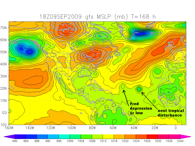
There are a lot of scenarios, but here's one from the GFS tropical model for next Wednesday afternoon on the 16th. It shows the remnants of Fred (or much less likely a depression) having been steered westward by a new ridge. There's also a new tropical cyclone behind it. Since 7 days out is extremely unreliable, I wouldn't put too much faith in it right now, but some of the other models also show this scenario. Just way too early too tell. But I wouldn't expect to see anything left of it by that time.

Image
Last edited by ozonepete on Wed Sep 09, 2009 7:24 pm, edited 1 time in total.
0 likes   

User avatar
cycloneye
Admin
Admin
Posts: 145322
Age: 68
Joined: Thu Oct 10, 2002 10:54 am
Location: San Juan, Puerto Rico

Re: ATL: HURRICANE FRED (07L)

#513 Postby cycloneye » Wed Sep 09, 2009 7:23 pm

SSD dvorak numbers continue to go down.

09/2345 UTC 15.0N 33.5W T4.5/5.5 FRED -- Atlantic

http://www.ssd.noaa.gov/PS/TROP/tdpositions.html
0 likes   

User avatar
wxman57
Moderator-Pro Met
Moderator-Pro Met
Posts: 22979
Age: 67
Joined: Sat Jun 21, 2003 8:06 pm
Location: Houston, TX (southwest)

Re: ATL: HURRICANE FRED (07L)

#514 Postby wxman57 » Wed Sep 09, 2009 7:31 pm

Well, Fred's on his way out now. Bye, Fred.
0 likes   

User avatar
cycloneye
Admin
Admin
Posts: 145322
Age: 68
Joined: Thu Oct 10, 2002 10:54 am
Location: San Juan, Puerto Rico

Re: ATL: HURRICANE FRED (07L)

#515 Postby cycloneye » Wed Sep 09, 2009 7:41 pm

00 UTC Best Track=95kts

AL, 07, 2009091000, , BEST, 0, 150N, 335W, 95, 965, HU

ftp://ftp.tpc.ncep.noaa.gov/atcf/tcweb/ ... 009.invest
0 likes   

User avatar
brunota2003
S2K Supporter
S2K Supporter
Posts: 9476
Age: 34
Joined: Sat Jul 30, 2005 9:56 pm
Location: Stanton, KY...formerly Havelock, NC
Contact:

#516 Postby brunota2003 » Wed Sep 09, 2009 7:46 pm

Wow...the inner core really fell apart...it only has 50% of an eyewall according to microwave images (the southern half is completely gone). I wonder if it was actually closer to Charley's strength earlier before the attempted ERC.
0 likes   

User avatar
AdamFirst
S2K Supporter
S2K Supporter
Posts: 2491
Age: 36
Joined: Thu Aug 14, 2008 10:54 am
Location: Port Saint Lucie, FL

#517 Postby AdamFirst » Wed Sep 09, 2009 7:55 pm

What's going on with the satellite? Hasn't updated in hours.
0 likes   

cyclonic chronic

#518 Postby cyclonic chronic » Wed Sep 09, 2009 8:04 pm

http://cimss.ssec.wisc.edu/tropic/real- ... hr_03.html

u can see dry air getting drawn into the S.-S.W. side of fred at about 1800 hrs today. IMO the dry mid-level air the NHC has been talkin bout has taken its toll on the R.I. since he spun up so fast, the way down should be quick too!! still nice last 24 hrs. fred!!
0 likes   

Derek Ortt

#519 Postby Derek Ortt » Wed Sep 09, 2009 8:16 pm

there was no attempted EWRC. It was just blasted apart by shear
0 likes   

ozonepete
Professional-Met
Professional-Met
Posts: 4743
Joined: Mon Sep 07, 2009 3:23 pm
Location: From Ozone Park, NYC / Now in Brooklyn, NY

Re:

#520 Postby ozonepete » Wed Sep 09, 2009 8:21 pm

Derek Ortt wrote:there was no attempted EWRC. It was just blasted apart by shear


There was clearly an attempted ERC. And that ERC was blasted by the DRY air, not shear. I still don't see any significant shear effects, i.e. central thunderstorms being blown away from the low level center.
0 likes   


Return to “2009”

Who is online

Users browsing this forum: No registered users and 5 guests