MELOR passing just to the west of Tokyo:
Temp 72 °F
Mostly Cloudy
Humidity: 83%
Dew Point: 66 °F
Wind: 41 mph from the South
Wind Gust: 61 mph
Pressure: 29.18 in (Steady)
Visibility: 3.7 miles
WPAC : TROPICAL STORM MELOR (20W)
Moderator: S2k Moderators
-
ozonepete
- Professional-Met

- Posts: 4743
- Joined: Mon Sep 07, 2009 3:23 pm
- Location: From Ozone Park, NYC / Now in Brooklyn, NY
Re: WPAC : TYPHOON MELOR (20W)
0 likes
-
ozonepete
- Professional-Met
- Posts: 4743
- Joined: Mon Sep 07, 2009 3:23 pm
- Location: From Ozone Park, NYC / Now in Brooklyn, NY
Re: WPAC : TYPHOON MELOR (20W)
Here's more from University of Wyoming METAR translations:
A windy morning in Tokyo.
Note that at 2230Z they had winds of 43 knots gusting to 59 knots. That's 49 mph gusting to 68 mph. Also we can see from the data that the eye/center passed over Tokyo. Note that the wind direction went from northwest to calm and then south, implying the center passed over them from southeast to north or northwest.
Code: Select all
Observations for TOKYO, Japan (RJTT)
Location: 35.55N 139.78E 8 meters
2300Z 6 Oct 2009 to 2330Z 7 Oct 2009
STN     TIME ALTM   TMP DEW RH  DIR SPD GUS VIS  CLOUDS                  Weather
     DD/HHMM inHg   F   F   %   deg kt  kt  mile
==== ======= ====== === === === === === === ==== ======= ======= ======= ============
RJTT 07/2330  29.18  72  66  83 190  36  53  3.7  FEW008  SCT025  BKN090
RJTT 07/2300  29.18  72  68  88 180  37  50  1.5  FEW008  SCT015  BKN025 RWF
RJTT 07/2230  29.18  73  66  78 170  43  59  3.1  FEW008  SCT015  BKN020 RWF
RJTT 07/2200  29.20  70  68  94 140  15  26  6.2  FEW008  SCT015  BKN020 RW-
RJTT 07/2130  29.23  63  59  88       2      6.2  FEW002  BKN010  BKN020 RW-
RJTT 07/2100  29.29  61  59  94 270   7      1.2  FEW002  SCT004  BKN010 RW+F
RJTT 07/2030  29.32  63  59  88 330  11      1.2  FEW003  SCT007  BKN020 RW+F
RJTT 07/2000  29.32  61  59  94 340   5      3.1  FEW005  SCT008  BKN025 RWF
RJTT 07/1930  29.35  61  59  94 320  18      1.5  FEW006  SCT008  BKN020 RWF
RJTT 07/1900  29.38  61  59  94 290  21      0.8  FEW002  SCT006  BKN008 RW+F
A windy morning in Tokyo.
Note that at 2230Z they had winds of 43 knots gusting to 59 knots. That's 49 mph gusting to 68 mph. Also we can see from the data that the eye/center passed over Tokyo. Note that the wind direction went from northwest to calm and then south, implying the center passed over them from southeast to north or northwest.
0 likes
-
ozonepete
- Professional-Met
- Posts: 4743
- Joined: Mon Sep 07, 2009 3:23 pm
- Location: From Ozone Park, NYC / Now in Brooklyn, NY
Re: WPAC : TYPHOON MELOR (20W)
Tokyo at 00Z:
Pressure still dropping.
Code: Select all
Wind  from the S (190 degrees) at 47 MPH (41 KT) gusting to 64 MPH (56 KT)
Visibility  4 mile(s)
Sky conditions  mostly cloudy
Temperature  73 F (23 C)
Dew Point  64 F (18 C)
Relative Humidity  73%
Pressure (altimeter)  29.15 in. Hg (0987 hPa)
ob  RJTT 080000Z 19041G56KT 7000 FEW010 SCT025 BKN080 23/18 Q0987
Pressure still dropping.
0 likes
-
Tiger Beer
- Tropical Wave

- Posts: 1
- Joined: Wed Oct 07, 2009 8:24 pm
Re: WPAC : TYPHOON MELOR (20W)
I'm in Japan now. I was just searcing for Super Typhoon Melor and found this website.
I'm in Niigata, which isn't where the full brunt of it is hitting, but very strong winds here nontheless. Very dark as well.
I'm in Niigata, which isn't where the full brunt of it is hitting, but very strong winds here nontheless. Very dark as well.
0 likes
-
cycloneye

- Admin

- Posts: 149275
- Age: 69
- Joined: Thu Oct 10, 2002 10:54 am
- Location: San Juan, Puerto Rico
Re: WPAC : SEVERE TROPICAL STORM MELOR (20W)
Downgraded to severe tropical storm by jma.
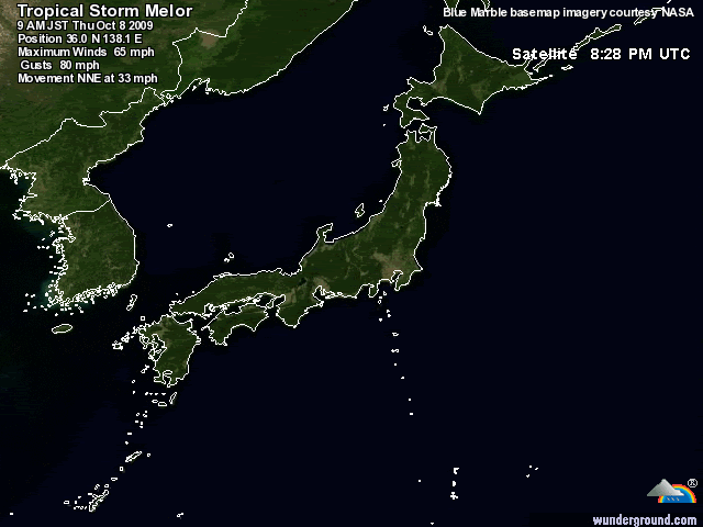
STS 0918 (Melor)
Issued at 01:05 UTC, 8 October 2009
<Analyses at 08/00 UTC>
Scale Large
Intensity -
Center position N36°05'(36.1°)
E138°50'(138.8°)
Direction and speed of movement NE 50km/h(26kt)
Central pressure 975hPa
Maximum sustained wind speed 30m/s(60kt)
Maximum wind gust speed 45m/s(85kt)
Area of 50kt winds or more SE220km(120NM)
NW170km(90NM)
Area of 30kt winds or more E650km(350NM)
W430km(230NM
0 likes
Visit the Caribbean-Central America Weather Thread where you can find at first post web cams,radars
and observations from Caribbean basin members Click Here
and observations from Caribbean basin members Click Here

-
brunota2003

- S2K Supporter

- Posts: 9476
- Age: 35
- Joined: Sat Jul 30, 2005 9:56 pm
- Location: Stanton, KY...formerly Havelock, NC
- Contact:

Re: WPAC : TYPHOON MELOR (20W)
breeze wrote:Weather Watcher wrote:Has anyone heard from Infdidoll yet?
I pray that you are doing ok.
Please let us know
I keep finding myself checking in to see if Infdidoll has posted, as well. I feel hopeful that
base personnel has taken care of them. I'm hoping all of our members from Japan are safe!
I'm still here! I took some video which I posted up on YouTube of the hours before the storm. The video doesn't seem to do it as much justice, as it seems like most storm videos really don't. I guess it's different when you are standing outside feeling the pressure change, the sound of the wind and watching how fast the clouds are moving. http://www.youtube.com/watch?v=YmfBjflIBXo
At around 6:30 p.m. the other day, I posted that the storm wasn't all that bad and it seemed like all that changed within the time span of a half hour! I hadn't seen things change so rapidly since I lived in the midwest during tornado season. The last video I got was at 8:00p.m.. I had to take it out the front door of my apartment because I'd already secured the back sliding doors. Through the window in my bedroom, I could see waves slamming into the wall outside and spraying over the edge. I was shocked because we live in an area where we just don't really have waves, at all, normally. By 10:00, the wind gusts were so strong that I wouldn't even open the front door. I'm small and wasn't about to fight a war with strong winds and a large door.
It grew progressively louder and I brought a mattress out into our living room for the kids and tried to keep them occupied. They were already asking, "What's that noise?!" It was so loud I was up until 4:30 in the morning. We were lucky and kept power through the whole thing, but we live off the military bases. I've heard you're more likely to lose power on base than off base. I will say that the Japanese really know how to build for these storms. Our building felt really secure and not losing power, I was able to keep in touch with family and my husband who is in Virginia for training (he left the morning it hit). You could feel the floor vibrate from wind gusts going under the building. We didn't get much rain, though...so I guess we got 'Typhoon Lite' - a lot of wind, no rain.
I'm glad I didn't listen to the current TCCOR...which only had us at a level 3 (initiate general clean-up around homes and offices). I'm certain I'd be missing some lawn furniture. I brought everything in after a plastic chair raced from one end of the balcony to the other. Overall, for a first typhoon experience, it wasn't bad. The thought of what COULD have happened was worse, especially being alone with 2 kids. As far as damage, we did have grating secured over one of the openings in our balcony that was ripped off and a we had a screen separated from the frame, but that was it. The storm surge created some pretty big waves. I'm waiting for the Okinawan surfers to come out in full force.
Thanks for the updates and advice, everyone! It's a beautiful day here so we'll enjoy it until the next one...and I hear Okinawa usually has 5-6 typhoons in the area per year. I hear we're behind this season....may be more catching up to do...Now to go clean all that sea spray all my windows which are now completely filthy!
0 likes
-
JonathanBelles
- Professional-Met
- Posts: 11430
- Age: 35
- Joined: Sat Dec 24, 2005 9:00 pm
- Location: School: Florida State University (Tallahassee, FL) Home: St. Petersburg, Florida
- Contact:
"The thought of what COULD have happened was worse, especially being alone with 2 kids." --Infdidoll
I wanted to quote that to make a point. With Hurricanes or Typhoons, you did the right thing. You prepared for the worst, and hoped for the best. This is what needs to be done for all tropical systems, no matter where you live.
We are glad you are ok Infdidoll!!
I wanted to quote that to make a point. With Hurricanes or Typhoons, you did the right thing. You prepared for the worst, and hoped for the best. This is what needs to be done for all tropical systems, no matter where you live.
We are glad you are ok Infdidoll!!
0 likes


Re: WPAC : SEVERE TROPICAL STORM MELOR (20W)
Wow! What an experience you had! Thanks so much for letting us know you're ok, Infdidoll!
It's good to see you've got a beautiful day to enjoy, and I'm glad things weren't as bad as
they could have been, after all!
It's good to see you've got a beautiful day to enjoy, and I'm glad things weren't as bad as
they could have been, after all!
0 likes
-
ozonepete
- Professional-Met
- Posts: 4743
- Joined: Mon Sep 07, 2009 3:23 pm
- Location: From Ozone Park, NYC / Now in Brooklyn, NY
Re: WPAC : SEVERE TROPICAL STORM MELOR (20W)
I'm really glad too! Really glad to hear you did the right things and survived it OK. Just remember to evacuate if they ever tell you to. Never second guess it.
0 likes
Re: WPAC : SEVERE TROPICAL STORM MELOR (20W)
Thanks for the kind thoughts! My fear is going away the more I learn to be prepared. Morakot came close...this one came even closer...Thank God for gradual acclimations, right? But the excitement might not be over...Looks like something brewing on the horizon according to the JTWC...I saw this on satellite images earlier and thought, "That looks like the beginning of another one...."
May be time for a new thread for a new system soon...
WTPN21 PGTW 080230
MSGID/GENADMIN/NAVMARFCSTCEN PEARL HARBOR HI/JTWC//
SUBJ/TROPICAL CYCLONE FORMATION ALERT//
RMKS/
1. FORMATION OF A SIGNIFICANT TROPICAL CYCLONE IS POSSIBLE WITHIN
150 NM EITHER SIDE OF A LINE FROM 14.3N 143.4E TO 19.1N 142.0E
WITHIN THE NEXT 06 TO 24 HOURS. AVAILABLE DATA DOES NOT JUSTIFY
ISSUANCE OF NUMBERED TROPICAL CYCLONE WARNINGS AT THIS TIME. WINDS
IN THE AREA ARE ESTIMATED TO BE 20 TO 25 KNOTS. METSAT IMAGERY AT
080200Z INDICATES THAT A CIRCULATION CENTER IS LOCATED NEAR 15.0N
143.3E. THE SYSTEM IS MOVING NORTH-NORTHWESTWARD AT 08 KNOTS.
2. REMARKS: THE AREA OF CONVECTION PREVIOUSLY LOCATED NEAR 14.2N
143.6E IS NOW LOCATED NEAR 15.0N 143.3E, APPROXIMATELY 120 NM
NORTHWEST OF GUAM. ANIMATED MULTISPECTRAL SATELLITE IMAGERY AND
A 072031Z SSMI IMAGE INDICATE A CONSOLIDATING LOW-LEVEL
CIRCULATION CENTER (LLCC) WITH FORMATIVE CONVECTIVE BANDING AND
DEEP CONVECTION OVER THE NORTHERN SEMI-CIRCLE. A 072046Z QUIKSCAT
IMAGE INDICATES 15 TO 20 KNOT UNFLAGGED WINDS AROUND A SYMMETRIC
LLCC WITH STRONGER WINDS TO THE NORTHEAST. ANIMATED WATER VAPOR
IMAGERY DEPICTS FAIR OUTFLOW INTO A TROPICAL UPPER TROPOSPHERIC
TROUGH (TUTT) CELL TO THE NORTH WITH WEAK VERTICAL WIND SHEAR AND
DIFFLUENT SOUTHERLY FLOW OVER THE LLCC. MAXIMUM SUSTAINED SURFACE
WINDS ARE ESTIMATED AT 20 TO 25 KNOTS. MINIMUM SEA LEVEL PRESSURE
IS ESTIMATED TO BE NEAR 1002 MB. THE POTENTIAL FOR THE DEVELOPMENT
OF A SIGNIFICANT TROPICAL CYCLONE WITHIN THE NEXT 24 HOURS IS GOOD.
3. THIS ALERT WILL BE REISSUED, UPGRADED TO WARNING OR CANCELLED
BY 090230Z.//
NNNN
0 likes
-
theavocado

- Professional-Met
- Posts: 162
- Age: 49
- Joined: Sun Mar 22, 2009 8:54 pm
- Location: NOLA
Re: WPAC : SEVERE TROPICAL STORM MELOR (20W)
Infdidoll wrote:May be time for a new thread for a new system soon...
I think the board is one step ahead of you, that's 92W.
0 likes
-
helmingstay
- Tropical Wave
- Posts: 4
- Joined: Mon Oct 05, 2009 11:13 pm
Re: WPAC : SEVERE TROPICAL STORM MELOR (20W)
Any reports of the wave action and storm surge along the east coast? I'm still shocked at the lack of news from Tokyo...
0 likes
Re: WPAC : SEVERE TROPICAL STORM MELOR (20W)
theavocado wrote:Infdidoll wrote:May be time for a new thread for a new system soon...
I think the board is one step ahead of you, that's 92W.
I should have had faith! haha...Saw it right after I posted that.
0 likes
-
alan1961

- Category 2

- Posts: 771
- Joined: Mon Mar 20, 2006 11:58 am
- Location: Derby, Derbyshire, England
- Contact:
Re: WPAC : SEVERE TROPICAL STORM MELOR (20W)
High waves flooded 30 houses in Kanagawa
Typhoon Melor has caused high waves on the Pacific coast in Kanagawa Prefecture, flooding some houses.
Hayama town's fire department says high waves went over the breakwater and reached a residential area in Isshiki district, flooding about 30 houses on Thursday.
The Yokohama Meteorological Observatory says the typhoon caused high waves on the Miura Peninsula, where the town is located, just when it was high tide in the region.
Local authorities are asking people to move to higher ground such as upstairs in their homes, as the sea remains rough.
http://www.nhk.or.jp/daily/english/fixe ... 1_256k.asx
Strong gusts of wind hit Ibaraki Prefecture
Due to the typhoon moving through central Japan, strong gusts of wind have hit two separate locations in Ibaraki Prefecture, north of Tokyo.
Gusts of wind whipped Tsuchiura City at around 5 AM on Thursday morning.
They blew away the roofs of about 50 homes as well as numerous sign boards, broke off electric polls, and smashed car windows.
As of 8:10 AM, about 1,990 households are suffering from loss of power in the region.
Gusts of wind also hit Ryugasaki City at 5 AM, causing damage to some houses.
Separately, about 150 households have been flooded in Saitama and Chiba Prefectures, due to the strong storm.
http://www.nhk.or.jp/daily/english/fixe ... 0_256k.asx
http://www.fnn-news.com/en/news/headlin ... 64305.html (japanese language)
http://news.bbc.co.uk/1/hi/world/asia-p ... 296131.stm
Last edited by alan1961 on Thu Oct 08, 2009 5:40 am, edited 1 time in total.
0 likes
-
alan1961
- Category 2
- Posts: 771
- Joined: Mon Mar 20, 2006 11:58 am
- Location: Derby, Derbyshire, England
- Contact:
Re: WPAC : SEVERE TROPICAL STORM MELOR (20W)
Is El Nino behind spate of Pacific typhoons? (CNN)
http://edition.cnn.com/2009/TECH/10/07/ ... cnnSTCText
http://edition.cnn.com/2009/TECH/10/07/ ... cnnSTCText
0 likes
Who is online
Users browsing this forum: No registered users and 22 guests