ATL: ANDREA - Post-Tropical
Moderator: S2k Moderators

Re: ATL: INVEST 91L
N2FSU wrote:Whatever this is, I'm about in the middle of it. Aboard the Carnival Paradise sailing back to Tampa.
Present position 24.3/84.8. Rough ride with constant heavy rain, visibility looks to be about 1/4 mi at the surface. Can't give you the winds because they have had the winds and present GPS position disabled the whole cruise. No sun today. Oh well, it's 5 o'clock somewhere!
Wow! Thanks for posting! I hope it does not get any worse.
0 likes
-
northjaxpro

- S2K Supporter

- Posts: 8900
- Joined: Mon Sep 27, 2010 11:21 am
- Location: Jacksonville, FL
Yeah, the Jax NWS just posted Flood Watch within the past hour. The Jax NWS mets in their late morning AFD is anticipating a landfall across the Suwannee River basin region by late tomorrow. However, this system will be sheared mostly, so if the coc makes landfall around Cedar Key, that would put much of the heaviest rain and possible severe weather across Jax area and south down the east coast to Daytona. It makes sense to hoist the flood watch at this point for sure.
0 likes
NEVER, EVER SAY NEVER in the tropics and weather in general, and most importantly, with life itself!!
________________________________________________________________________________________
Fay 2008 Beryl 2012 Debby 2012 Colin 2016 Hermine 2016 Julia 2016 Matthew 2016 Irma 2017 Dorian 2019
________________________________________________________________________________________
Fay 2008 Beryl 2012 Debby 2012 Colin 2016 Hermine 2016 Julia 2016 Matthew 2016 Irma 2017 Dorian 2019

Re: ATL: INVEST 91L
I see the inflow that some of you are speaking of but that looks like just inflow to another MLC low level clouds just north of there are moving from southeast to northwest
0 likes
The following post is NOT an official forecast and should not be used as such. It is just the opinion of the poster and may or may not be backed by sound meteorological data. It is NOT endorsed by any professional institution including storm2k.org For Official Information please refer to the NHC and NWS products.
-
wxman57

- Moderator-Pro Met

- Posts: 23117
- Age: 68
- Joined: Sat Jun 21, 2003 8:06 pm
- Location: Houston, TX (southwest)
Re:
northjaxpro wrote:It is forecast to make landfall within the next 36 hours, although this could change of course.
Remember, this system has all convection well east of the center. "Landfall" is defined as when the center reaches the coast. However, heavy rain/squalls will begin moving inland this afternoon not in 36 hrs.
0 likes

-
Aric Dunn
- Category 5

- Posts: 21238
- Age: 43
- Joined: Sun Sep 19, 2004 9:58 pm
- Location: Ready for the Chase.
- Contact:
Re: ATL: INVEST 91L
clearly there is a broad closed circ. and a very sharp hook the flow. that vort being pulled back toward the convection maybe be what takes over. it should get some energy assist from the strong inflow and begin to tighten up as it approaches the convection. the fact that there has not been another vort being spit out leads me to believe this be at least partly the case.
0 likes
Note: If I make a post that is brief. Please refer back to previous posts for the analysis or reasoning. I do not re-write/qoute what my initial post said each time.
If there is nothing before... then just ask
Space & Atmospheric Physicist, Embry-Riddle Aeronautical University,
I believe the sky is falling...
If there is nothing before... then just ask
Space & Atmospheric Physicist, Embry-Riddle Aeronautical University,
I believe the sky is falling...
Re: ATL: INVEST 91L
I'm sure this is partly why 91L looks show shabby.

0 likes
The following post is NOT an official forecast and should not be used as such. It is just the opinion of the poster and may or may not be backed by sound meteorological data. It is NOT endorsed by any professional institution including storm2k.org For Official Information please refer to the NHC and NWS products.
-
northjaxpro
- S2K Supporter
- Posts: 8900
- Joined: Mon Sep 27, 2010 11:21 am
- Location: Jacksonville, FL
Re: Re:
wxman57 wrote:northjaxpro wrote:It is forecast to make landfall within the next 36 hours, although this could change of course.
Remember, this system has all convection well east of the center. "Landfall" is defined as when the center reaches the coast. However, heavy rain/squalls will begin moving inland this afternoon not in 36 hrs.
I know wxman57. I just referenced this in my recent post just above yours wxman. You overlooked it.
0 likes
NEVER, EVER SAY NEVER in the tropics and weather in general, and most importantly, with life itself!!
________________________________________________________________________________________
Fay 2008 Beryl 2012 Debby 2012 Colin 2016 Hermine 2016 Julia 2016 Matthew 2016 Irma 2017 Dorian 2019
________________________________________________________________________________________
Fay 2008 Beryl 2012 Debby 2012 Colin 2016 Hermine 2016 Julia 2016 Matthew 2016 Irma 2017 Dorian 2019
Re: ATL: INVEST 91L
MGC wrote:91L don't look any better this morning than it did yesterday. Broad area of low pressure, with convection displaced well to the east. Dry air and shear are issues. IMO 91L does not meet the criteria to be designate a tropical cyclone at this time.....of course who knows what the NHC will do.......MGC
Sorry to disagree with you, compared to 24 hrs ago 91L looks much better, not that it has the best presentation on satellite that a tropical system should have but for this time of the year this is almost as good as it gets.
24 hrs ago the deep convection was well removed from the COC, this morning is much closer with a possible LLC trying to develop even closer.
0 likes
-
Meow
Re: ATL: INVEST 91L
AN AIR FORCE RESERVE RECONNAISSANCE
AIRCRAFT IS SCHEDULED TO INVESTIGATE THIS DISTURBANCE THIS
AFTERNOON...IF NECESSARY.
Maybe we will see Subtropical Storm Andrea within one day.
AIRCRAFT IS SCHEDULED TO INVESTIGATE THIS DISTURBANCE THIS
AFTERNOON...IF NECESSARY.
Maybe we will see Subtropical Storm Andrea within one day.
0 likes
-
HURRICANELONNY
- Category 5
- Posts: 1390
- Joined: Wed May 07, 2003 6:48 am
- Location: HOLLYWOOD.FL
Re: ATL: INVEST 91L
The good news is most of the rain will be in area's needing rain. Looking at radar most of the moisture is staying north and west of S. Fl. My area doesn't need more rain. Were above normal and my grass is lush green. 
0 likes
hurricanelonny
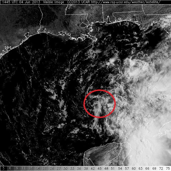
The circulation is either elongated W to E now or their is a new circulation closer to 87W long, the wind direction at buoy 42003 has been more from the east during the past 2 hours or so, it should had been more from the straight SE for the low pressure center to be located SW of it.
http://www.ndbc.noaa.gov/show_plot.php? ... _label=CDT
http://www.ndbc.noaa.gov/show_plot.php? ... _label=CDT
0 likes
-
wxman57
- Moderator-Pro Met
- Posts: 23117
- Age: 68
- Joined: Sat Jun 21, 2003 8:06 pm
- Location: Houston, TX (southwest)
Re: ATL: INVEST 91L
NDG, looks like an outflow boundary now moving west through that area you circled in red. I don't see much of any LLC there. Still looks like a giant, broad (200+ miles) across circulation to me.
Added: Or, it's spitting out another small vortex to the west now. I don't see much significant convergence toward that point just west of the convection. Convection is dropping off now, too, and shifting farther east. Don't think it qualifies for a TD yet.
Added: Or, it's spitting out another small vortex to the west now. I don't see much significant convergence toward that point just west of the convection. Convection is dropping off now, too, and shifting farther east. Don't think it qualifies for a TD yet.
0 likes

Re: ATL: INVEST 91L
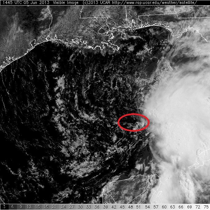
Might go straight to TS warning status if the NHC holds off till late this afternoon. Latest VIS SAT clearly shows a devloping LLC on the edge of convection. Looks very similar to TS Debby last year at this time.
http://www.aviationweather.gov/adds/satellite/displaySat.php?region=TPA&isingle=multiple&itype=vis
http://www.aviationweather.gov/adds/satellite/displaySat.php?region=TPA&isingle=multiple&itype=vis
0 likes
Re: ATL: INVEST 91L
wxman57 wrote:NDG, looks like an outflow boundary now moving west through that area you circled in red. I don't see much of any LLC there. Still looks like a giant, broad (200+ miles) across circulation to me.
Added: Or, it's spitting out another small vortex to the west now. I don't see much significant convergence toward that point just west of the convection. Convection is dropping off now, too, and shifting farther east. Don't think it qualifies for a TD yet.
Yes, you are correct, my red circle was to point out the broad COC overall, not that it is an LLC, if there is an LLC forming it will be east of this broad circulation, IMO.
0 likes
-
cycloneye

- Admin

- Posts: 148685
- Age: 69
- Joined: Thu Oct 10, 2002 10:54 am
- Location: San Juan, Puerto Rico
Re: ATL: INVEST 91L - Recon
Dave,this afternoon mission is a go.
REPRPD
WEATHER RECONNAISSANCE FLIGHTS
CARCAH, NATIONAL HURRICANE CENTER, MIAMI, FL.
1230 PM EDT WED 05 JUNE 2013
SUBJECT: TROPICAL CYCLONE PLAN OF THE DAY (TCPOD)
VALID 06/1100Z TO 07/1100Z JUNE 2013
TCPOD NUMBER.....13-005
I. ATLANTIC REQUIREMENTS
1. SUSPECT AREA -- GULF OF MEXICO
FLIGHT ONE -- TEAL 72
A. 06/1800Z
B. AFXXX 0301A CYCLONE
C. 06/1645Z
D. 28.3N 85.8W
E. 06/1730Z TO 06/2300Z
F. SFC TO 10,000 FT
FLIGHT TWO -- TEAL 73
A. 07/0600Z
B. AFXXX 0401A CYCLONE
C. 07/0345Z
D. 29.3N 83.7W
E. 07/0530 TO 07/1000Z
F. SFC TO 10,000 FT
2. OUTLOOK FOR SUCCEEDING DAY: PSBL FIX MISSION
NEAR 33.0N AND 78.0W AT 07/1800Z
0 likes
Visit the Caribbean-Central America Weather Thread where you can find at first post web cams,radars
and observations from Caribbean basin members Click Here
and observations from Caribbean basin members Click Here
-
wxman57
- Moderator-Pro Met
- Posts: 23117
- Age: 68
- Joined: Sat Jun 21, 2003 8:06 pm
- Location: Houston, TX (southwest)
Re: ATL: INVEST 91L
Here's the broad circulation I'm seeing on satellite & in the obs. There could be another small vortex in the NE part of the circled area, but it appears to be separating from the convection to the east (it may be moving westward). Hard to tell. Don't see much point in sending recon out today. Obs and satellite images tell the story.

0 likes
Who is online
Users browsing this forum: No registered users and 12 guests