Texas Fall 2013

U.S. & Caribbean Weather Discussions and Severe Weather Events

Moderator: S2k Moderators

Forum rules

The posts in this forum are NOT official forecast and should not be used as such. They are just the opinion of the poster and may or may not be backed by sound meteorological data. They are NOT endorsed by any professional institution or STORM2K.

Help Support Storm2K
Message
Author
User avatar
NDG
S2K Supporter
S2K Supporter
Posts: 15446
Joined: Sun Jul 09, 2006 10:14 pm
Location: Orlando, FL

Re:

#501 Postby NDG » Tue Nov 19, 2013 6:30 pm

Ntxw wrote:The euro is still very on for wintry precip for pretty much the NW and northern half of Texas, quite impressive actually (foot in some places). I think the reason it has so much is it may be mixing some of it with sleet. This will be interesting, I don't think the GFS has a handle on the cold air mass just yet and ecmwf is in it's kill mid range zone, big highs 1050+ don't come and go quietly. Once the upper low passes overhead that's prime time and it may not be the only threat before this month is out, Rex Block.

93 was mentioned and I think it's a good month to compare, the atmosphere is in a very Nino like state in the north Pacific

It's either going to rain a cold rain in the 30s or be a big wintry mess


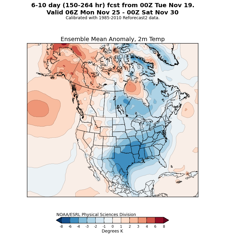
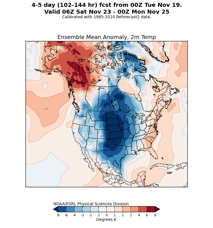
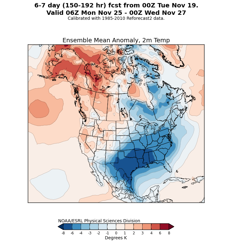
I totally agree in that the GFS may not be handling the cold that well, to me it is moving the Arctic air at the surface eastward too fast, the ensemble reforecast map below has the core of the cold air finding a home in TX & the lower MS river valley a bit longer than what the GFS shows.
Image
Image
Image
0 likes   

User avatar
Ntxw
Storm2k Moderator
Storm2k Moderator
Posts: 22785
Joined: Wed Oct 21, 2009 6:34 pm
Location: DFW, Texas

#502 Postby Ntxw » Tue Nov 19, 2013 6:38 pm

:uarrow: This is why HPC is upping the probabilities of freezing rain I bet. These are pretty hefty values for being several days out.

Image

Image

And this is not a good time for something like this since people will start heading out on the roads once the kids on are break for Thanksgiving travel.
0 likes   
The above post and any post by Ntxw is NOT an official forecast and should not be used as such. It is just the opinion of the poster and may or may not be backed by sound meteorological data. It is NOT endorsed by any professional institution including Storm2k. For official information, please refer to NWS products.

  Help support Storm2K!
Help Support Storm2K

User avatar
TeamPlayersBlue
Category 5
Category 5
Posts: 3445
Joined: Tue Feb 02, 2010 1:44 am
Location: Denver/Applewood, CO

Re: Texas Fall 2013

#503 Postby TeamPlayersBlue » Tue Nov 19, 2013 6:42 pm

Ntxw wrote:
NDG wrote::uarrow: I hate to agree on the saying that ridging in the gulf of Alaska is due to the "warm" waters, to me it makes more sense to say that the "warmer waters" is due to the ridging in the gulf of Alaska, besides we are talking SSTs in the gulf of Alaska are currently only in the 40s and 50s, JMO.


Definitely, it's the chicken or the egg came first question. It's a feed back, regardless which started it one helps the other continue until something breaks the cycle. And it's about anomalies. It's cold yes, but it's relative to average and relative to other areas. The milder eastern north Pacific is counter acted by the cooler northwest Pacific and that's where the feedback begins, one magnets lower pressures and thus pumps more ridging down stream.


My amateur mind set always thought the location of the HP's in the Pacific or Atlantic had to do with the core of warm SST's in the Pacific and the Carribbean. Hence the VERY strong HP's in the Atlantic every summer from the warm GOM and Carribbean but hey, thats for some other thread. :)
0 likes   
Personal Forecast Disclaimer:
The posts in this forum are NOT official forecast and should not be used as such. They are just the opinion of the poster and may or may not be backed by sound meteorological data. They are NOT endorsed by any professional institution or storm2k.org. For official information, please refer to the NHC and NWS products.

User avatar
Ntxw
Storm2k Moderator
Storm2k Moderator
Posts: 22785
Joined: Wed Oct 21, 2009 6:34 pm
Location: DFW, Texas

Re: Texas Fall 2013

#504 Postby Ntxw » Tue Nov 19, 2013 6:59 pm

TeamPlayersBlue wrote:My amateur mind set always thought the location of the HP's in the Pacific or Atlantic had to do with the core of warm SST's in the Pacific and the Carribbean. Hence the VERY strong HP's in the Atlantic every summer from the warm GOM and Carribbean but hey, thats for some other thread. :)


Kind of the same outcome but a little bit different in the northern latitudes and time of year. There's a polar and arctic jet involved vs in the tropics where high pressure just dominates in the summer. In the far north pressures are lower and lower pressures is associated with cooler air (cooler sst's and back to the chicken or egg). And since the waters up there raw are much colder it's about which areas is warmer (or cooler) relative to another area.

This is why you can get a big storm on the arctic front in winter even after already being cold. It's not all about hot and cold air clashing it's about is one air mass warmer (or cooler) than the other. The difference makes a difference!
0 likes   
The above post and any post by Ntxw is NOT an official forecast and should not be used as such. It is just the opinion of the poster and may or may not be backed by sound meteorological data. It is NOT endorsed by any professional institution including Storm2k. For official information, please refer to NWS products.


  Help support Storm2K!

Help Support Storm2K


Jarodm12
Category 1
Category 1
Posts: 337
Joined: Sat Jan 29, 2011 8:05 pm

#505 Postby Jarodm12 » Tue Nov 19, 2013 7:28 pm

i dont understand why the nam shows all of this really dense cold air coming down off the rockies and bottle necks it in the pan handle from 60 to 80 hours? why is it not making any south eastward progression?
0 likes   

User avatar
ravyrn
S2K Supporter
S2K Supporter
Posts: 1000
Age: 42
Joined: Sun Aug 31, 2008 5:10 am
Location: Alderbranch, TX

Re: Texas Fall 2013

#506 Postby ravyrn » Tue Nov 19, 2013 10:47 pm

When would the precipitation impact the metroplex? If possible, be more specific than a certain day. Preferably, a day and time with like a +4/-4 hr period acceptable.

EDIT: Also, NWS FTW makes no mention of the freezing rain possibility for Friday/Saturday on their map, but do mention a Sunday possibility. But that HPC forecast is for the period between 6pm Thurs and 6pm Friday, yes?
0 likes   

User avatar
SouthernMet
Category 3
Category 3
Posts: 857
Joined: Sun Aug 29, 2010 8:23 pm
Location: fort worth, tx

Re: Texas Fall 2013

#507 Postby SouthernMet » Tue Nov 19, 2013 11:21 pm

Would be intrested to hear OrangeBlood's thoughts/analysis on this upcoming pattern, he usually has good insight & accurate observations.
0 likes   
Nothing that SouthernMet posts, is an official forecast,nor does it reflect views of STORM2K.. SouthernMet is just adding to the great discussions on STORM2K.. Refer to NWS for official forecasts.

orangeblood
S2K Supporter
S2K Supporter
Posts: 3714
Joined: Tue Dec 15, 2009 6:14 pm
Location: Fort Worth, TX

Re: Texas Fall 2013

#508 Postby orangeblood » Wed Nov 20, 2013 1:08 am

SouthernMet wrote:Would be intrested to hear OrangeBlood's thoughts/analysis on this upcoming pattern, he usually has good insight & accurate observations.


Glancing at the latest GFS and Canadian, all appear to be trending it the right direction for wintry weather in some parts of Texas. It appears North Texas has a brief shot at freezing rain late Friday night into Saturday morning. But the real fun and games start later on Sunday when the upper level energy comes out of the southwest, that second Arctic High coming down is the real deal and will more than likely be very difficult to erode away......At least more difficult than the models are currently showing.
Looking particularly at the partial thickness values, this is a shallow cold dense airmass so it looks more like a freezing rain/sleet type event. Canadian looks colder than the GFS with 1000-850 dm values approaching 129 near the metroplex late Sunday night with a fairly significant amount of precip moving through. To me, this would indicate a sleet event if enough low-level cold advection were still occurring. Haven't seen the new Euro yet, will look in the morning

The following post is NOT an official forecast and should not be used as such. It is just the opinion of the poster and may or may not be backed by sound meteorological data. It is NOT endorsed by any professional institution including storm2k.org. For official information, please refer to NWS products.
0 likes   

natlib
Tropical Storm
Tropical Storm
Posts: 159
Joined: Tue Dec 01, 2009 10:09 am
Location: San Angelo, TX

Re: Texas Fall 2013

#509 Postby natlib » Wed Nov 20, 2013 1:18 am

So I've got some playoff football to watch in Abilene on Saturday afternoon......I'd love to hear everyone's "unofficial" forecasts for what I can expect.
0 likes   

User avatar
Ntxw
Storm2k Moderator
Storm2k Moderator
Posts: 22785
Joined: Wed Oct 21, 2009 6:34 pm
Location: DFW, Texas

#510 Postby Ntxw » Wed Nov 20, 2013 7:28 am

I would expect a wintry mix of sorts in Abilene on Saturday especially Friday night. It will be cold, likely 30s all day there for your game and windy. I would be cautious Saturday night as the roads may freeze over. We won't have a handle on the cold air until we see it surge, it's shallow and it has beaten the models before even earlier this month.

Whether or not there is frozen precip, it's going to be very cold right on through Thanksgiving week. DFW may not make it past 50 until December. Monday-Tuesday may not get out of the 30s and just stays cold. Houston and Austin too remains in the chill, perhaps not quite that cold but 40s/50s looks good. Right now it looks like a chilly turkey day.
0 likes   
The above post and any post by Ntxw is NOT an official forecast and should not be used as such. It is just the opinion of the poster and may or may not be backed by sound meteorological data. It is NOT endorsed by any professional institution including Storm2k. For official information, please refer to NWS products.


  Help support Storm2K!

Help Support Storm2K


User avatar
vbhoutex
Storm2k Executive
Storm2k Executive
Posts: 29112
Age: 73
Joined: Wed Oct 09, 2002 11:31 pm
Location: Cypress, TX
Contact:

Re:

#511 Postby vbhoutex » Wed Nov 20, 2013 8:58 am

Ntxw wrote:I would expect a wintry mix of sorts in Abilene on Saturday especially Friday night. It will be cold, likely 30s all day there for your game and windy. I would be cautious Saturday night as the roads may freeze over. We won't have a handle on the cold air until we see it surge, it's shallow and it has beaten the models before even earlier this month.

Whether or not there is frozen precip, it's going to be very cold right on through Thanksgiving week. DFW may not make it past 50 until December. Monday-Tuesday may not get out of the 30s and just stays cold. Houston and Austin too remains in the chill, perhaps not quite that cold but 40s/50s looks good. Right now it looks like a chilly turkey day.

Are the soil temperatures that low in that area? I wouldn't be surprises with bridges and raised surfaces, but wonder about the roads in general freezing over. That being said. ALWAYS ERR ON THE SIDE OF CAUTION and BE CAREFUL if you do decide to go out in ANY ICY WEATHER.
As far as the weather in Houston on Thanksgiving, it would be nice for it to at least be cool. IIRC last year we were in shorts. :roll:
0 likes   
Skywarn, C.E.R.T.
Please click below to donate to STORM2K to help with the expenses of keeping the site going:
Image

User avatar
Ntxw
Storm2k Moderator
Storm2k Moderator
Posts: 22785
Joined: Wed Oct 21, 2009 6:34 pm
Location: DFW, Texas

#512 Postby Ntxw » Wed Nov 20, 2013 9:07 am

^I'm siding with caution. Abilene is not a dense urban center and freezes much quicker and they are higher up in elevation. I don't have a good sense on how cold this air mass really is but it may fall into the mid 20s there quickly which is usually cold enough no matter how warm.
0 likes   
The above post and any post by Ntxw is NOT an official forecast and should not be used as such. It is just the opinion of the poster and may or may not be backed by sound meteorological data. It is NOT endorsed by any professional institution including Storm2k. For official information, please refer to NWS products.


  Help support Storm2K!

Help Support Storm2K


ndale
Category 1
Category 1
Posts: 429
Joined: Tue Dec 29, 2009 11:12 am
Location: Pflugerville/Austin Tx

#513 Postby ndale » Wed Nov 20, 2013 9:10 am

I'm not that familiar with the HPC, does anyone know how accurate their forecast maps are regarding freezing rain probablility?
0 likes   
Any opinions stated are those of an amateur, please take with several grains of salt and for official forecast refer to the National Weather Service.

User avatar
vbhoutex
Storm2k Executive
Storm2k Executive
Posts: 29112
Age: 73
Joined: Wed Oct 09, 2002 11:31 pm
Location: Cypress, TX
Contact:

Re: Texas Fall 2013

#514 Postby vbhoutex » Wed Nov 20, 2013 9:13 am

Jeff Lindner's take on the incoming Arctic front. Mostly about SE TX, but mentions other areas too.
Rapidly changing conditions over the next several days as cold polar air floods into the US.

Today-early Friday:

Warm air advection will increase today as winds swing around to the ESE and SE allowing Gulf moisture to begin its return to the region. Short term models suggest a few showers may develop in this pattern across the coastal bend latter today and then spread northward into SE TX tonight into much of Thursday. Expect these showers to be mainly light and fast moving with rainfall amounts likely less than .25 of an inch. Surface dewpoints rise into the 60’s tonight and 70’s on Thursday and this over the cooler near shore waters may result in a bout of dense sea fog as early as Thursday morning and especially Friday morning.

Friday midday-Saturday:

Large 1050mb polar high originating out of a very cold NW Canada (current surface temperatures -20 to -30F) will plunge down the plains late this week sending a very cold and shallow arctic air mass into TX. Will go with the Canadian model as it is the fastest model as these shallow dense air masses tend to make very good progress even in the face of unfavorable upper level flow. Expect the front to blow through the Rio Grande plains before reaching Houston as the dense cold air dams against the slopes of the southern Rockies. High temperatures Friday will reach the 70’s before the front and rapidly fall into the 50’s with the front and into the 40’s a few hours post frontal passage. NW winds will howl in the 20-30mph range making wind chills in the 30’s by Friday evening. Expect a line of showers with the front and then rapid lifting of warm and moist air over the top of the shallow cold dome into Saturday. Even looks to be some mid-level instability in place Friday night for some elevated thunderstorms. Luckily surface temperatures and column profiles will keep everything liquid as it is only going to be cold near the surface…so all rain for Friday night into Saturday. Overrunning upglide pattern continues into Saturday as a large winter storm develops over the SW US. SW flow aloft will bring moisture back into the cold air at the surface over TX. Surface freezing line should remain well NW of our area (roughly from NW of Fort Worth to NW of Del Rio) so all liquid over the eastern part of the state. Highs on Saturday will hold in the low to mid 40’s under strong cold air advection and widespread rain and clouds. Highs on Sunday may reach into the low 50’s if there is any breaks in the clouds, but many areas may hold again in the 40’s as the cold air dome deepens.

Winds will also be a problem from Friday onward over the area and especially the Gulf. Cold air striking the still warm Gulf waters will help in downward momentum transfer and likely lead to near sustained Gale conditions Friday night into Saturday. Expect easily 35-40kts over the coastal waters and 25-30mph across inland locations. Winds may decrease some on Sunday before veering to the NE and E late Sunday as surface low pressure develops on the frontal boundary over the NW Gulf increasing winds again Monday and Tuesday.

Sunday-Tuesday:

Models have come into much better agreement on a winter storm solution for TX early next week. Large and cold upper level storm over the SW US will progress quickly into the state as early as late Sunday. This allows little time for the dense cold air mass to modify and has the potential to bring winter precipitation to much of W and NC TX Sunday night-Monday night. Models have also trended toward a coastal surface low formation solution off the middle TX coast by late Sunday which keeps NE winds in place across SE TX and the cold surface wedge locked in tight. Position of the track of the upper level storm supports a suppressed surface low track across our Gulf waters or offshore keeping the area within the cold sector. Expect widespread rain to develop again by late Sunday into Monday as the coastal trough forces lift and slings copious moisture back across the area. Temperatures will fall into the 30’s Sunday night and there is an outside chance that some of the rain could mix with sleet over our far northern counties Sunday night into Monday as the cold dome would be deeper at this point….but this is a low chance at the moment. Better chances for frozen precipitation will be NW of our area. Temperatures will then likely be steady in the 40’s all day Monday with widespread rainfall. Surface low deepening across the NW Gulf on Monday supports some strong E winds which could result in tidal run-up also. Storm system should progress east of the area by late Tuesday ending rainfall and clearing skies prior to Thanksgiving.

Rainfall amounts from Thursday-Tuesday will likely average 1-2 inches with isolated totals of 3-4 inches possible. Best chances for heavy rainfall will be Friday night with any elevated convection and again Monday night/Tuesday with the coastal storm.
0 likes   
Skywarn, C.E.R.T.
Please click below to donate to STORM2K to help with the expenses of keeping the site going:
Image

User avatar
Portastorm
Storm2k Moderator
Storm2k Moderator
Posts: 9914
Age: 63
Joined: Fri Jul 11, 2003 9:16 am
Location: Round Rock, TX
Contact:

Re: Texas Fall 2013

#515 Postby Portastorm » Wed Nov 20, 2013 10:50 am

First of all, where is weatherdude1108? I can't believe he didn't post about EWX's forecast discussion this morning and the mention of a wintry mix possibility Sunday evening?! :lol:

Second ... for ndale ... HPC is the Hydrometeorological Prediction Center. They're the NOAA guys/gals in Washington who do forecasts from a more national perspective. HPC is not a fly-by-night private sector outfit. They're legit.

Third and finally ... where is our friend wxman57?! Poor fella ... he must be hiding.
0 likes   
Any forecasts under my name are to be taken with a grain of salt. Get your best forecasts from the National Weather Service and National Hurricane Center.

User avatar
Tireman4
S2K Supporter
S2K Supporter
Posts: 5853
Age: 59
Joined: Fri Jun 30, 2006 1:08 pm
Location: Humble, Texas
Contact:

Re: Texas Fall 2013

#516 Postby Tireman4 » Wed Nov 20, 2013 11:05 am

Portastorm wrote:Third and finally ... where is our friend wxman57?! Poor fella ... he must be hiding.


I saw him on his bike riding past my library. Said, "to heck with this, I am riding south for the winter". LOL....
0 likes   

ouamber
Tropical Depression
Tropical Depression
Posts: 54
Joined: Wed Jan 04, 2012 4:29 pm

Re: Texas Fall 2013

#517 Postby ouamber » Wed Nov 20, 2013 3:56 pm

Hey everyone...does anyone have any clue as to where the low pressure system is going to eject to on Sunday-Tuesday time frame? The Canadian has it further north giving OK a good snow storm Sunday-Tuesday. What do you all see?
0 likes   

ndale
Category 1
Category 1
Posts: 429
Joined: Tue Dec 29, 2009 11:12 am
Location: Pflugerville/Austin Tx

Re: Texas Fall 2013

#518 Postby ndale » Wed Nov 20, 2013 4:45 pm

Portastorm wrote:First of all, where is weatherdude1108? I can't believe he didn't post about EWX's forecast discussion this morning and the mention of a wintry mix possibility Sunday evening?! :lol:

Second ... for ndale ... HPC is the Hydrometeorological Prediction Center. They're the NOAA guys/gals in Washington who do forecasts from a more national perspective. HPC is not a fly-by-night private sector outfit. They're legit.

Third and finally ... where is our friend wxman57?! Poor fella ... he must be hiding.


Thanks Portastorm, I was asking because the HPC shows a possibility of freezing rain almost to Austin on Friday and Saturday.
0 likes   
Any opinions stated are those of an amateur, please take with several grains of salt and for official forecast refer to the National Weather Service.

User avatar
wxman57
Moderator-Pro Met
Moderator-Pro Met
Posts: 22979
Age: 67
Joined: Sat Jun 21, 2003 8:06 pm
Location: Houston, TX (southwest)

Re: Texas Fall 2013

#519 Postby wxman57 » Wed Nov 20, 2013 4:53 pm

I don't think I'll be doing any biking this weekend...

Image
0 likes   

User avatar
somethingfunny
ChatStaff
ChatStaff
Posts: 3926
Age: 37
Joined: Thu May 31, 2007 10:30 pm
Location: McKinney, Texas

#520 Postby somethingfunny » Wed Nov 20, 2013 4:57 pm

I guess I ought to start paying attention, but my gut says that the Metroplex won't see anything of consequence from either of these systems. The second one will hopefully produce some snow within daytripping distance though!
0 likes   
I am not a meteorologist, and any posts made by me are not official forecasts or to be interpreted as being intelligent. These posts are just my opinions and are probably silly opinions.


Return to “USA & Caribbean Weather”

Who is online

Users browsing this forum: No registered users and 17 guests