
ATL: COLIN - Post-Tropical - Discussion
Moderator: S2k Moderators
-
Chris_in_Tampa
- Category 5

- Posts: 5101
- Age: 42
- Joined: Thu Jun 21, 2007 11:06 pm
- Location: Tampa, Florida, USA
- Contact:

Re: ATL: THREE - Tropical Depression - Discussion
NDG wrote:The weird thing is that it found lower pressures near the MLC than near the broad surface low but no LLC. yet.
It's not really that weird at all. There isn't a strong dominate surface low so the area that has the strongest sustained convection will probably have the lowest pressures.
0 likes

Re: ATL: THREE - Tropical Depression - Discussion
chaser1 wrote:NDG wrote:S-SSW winds is that the Recon is finding just to the west of the MLC, so nothing at the surface just yet underneath the MLC.
Exactly why I would've held off on an upgrade to T.D. Evidence of a sharp trough at the surface but no west winds. Meanwhile, with present upper level shear and limited banding or convection, I'd be remiss to label the broad surface low to the north as Depression either. Will a singular point that more clearly fits the definition of a T.D. form? I'd guess probably but not quite yet. If and when it does though, will quite possibly be at a point a bit east and south of the advisory
Plenty of west winds, is just a matter of time before an LLC forms, with ASCAT finding plenty of Tropical force winds around noon today.
0 likes
Re: ATL: THREE - Tropical Depression - Discussion
RL3AO wrote:NDG wrote:The weird thing is that it found lower pressures near the MLC than near the broad surface low but no LLC. yet.
It's not really that weird at all. There isn't a strong dominate surface low so the area that has the strongest sustained convection will probably have the lowest pressures.
I was just being sarcastic
0 likes
-
MGC

- S2K Supporter

- Posts: 5940
- Joined: Sun Mar 23, 2003 9:05 pm
- Location: Pass Christian MS, or what is left.
Re: ATL: THREE - Tropical Depression - Discussion
Looks a bit more organized. Still a sheared mess though. Might make it to TS....MGC
0 likes
-
TheAustinMan

- Category 5
- Posts: 1060
- Joined: Mon Jul 08, 2013 4:26 pm
- Location: Central TX / United States
Re: ATL: THREE - Recon
Gonzo upper-level aircraft will be flying around the area in tandem with AF307 to sample the upper-level environment around Tropical Depression Three, as well as investigating the wind shear as part of a larger research project dealing with sheared tropical cyclones.

0 likes
Treat my opinions with a grain of salt. For official information see your local weather service.
“It's tough to make predictions, especially about the future.”
“It's tough to make predictions, especially about the future.”

Re: ATL: THREE - Tropical Depression - Discussion
SeGaBob wrote:Does anyone think it'll get upgraded at 5pm?
Highly doubtful--they seem to be avoiding going into the strongest area so we're only getting sampling of the weaker winds. They'll probably wait until the strongest winds are either closer to the center or actually in the Gulf of Mexico before naming it.
0 likes
The above post is not official and should not be used as such. It is the opinion of the poster and may or may not be backed by sound meteorological data. It is not endorsed by any professional institution or storm2k.org. For official information, please refer to the NHC and NWS products.
-
CrazyC83
- Professional-Met

- Posts: 34315
- Joined: Tue Mar 07, 2006 11:57 pm
- Location: Deep South, for the first time!
Re: ATL: THREE - Recon
000
URNT15 KNHC 052023
AF307 0103A CYCLONE HDOB 30 20160605
201400 2155N 08604W 9663 00348 0055 +232 //// 182015 015 023 004 01
201430 2157N 08604W 9663 00353 0061 +228 //// 170016 016 024 005 01
201500 2158N 08605W 9664 00349 0061 +222 //// 170015 016 025 005 01
201530 2200N 08605W 9666 00348 //// +218 //// 172016 018 028 003 01
201600 2202N 08605W 9664 00351 0059 +230 +220 176017 018 014 001 00
201630 2203N 08605W 9665 00350 0061 +230 +224 174018 018 016 000 03
201700 2205N 08605W 9664 00354 0062 +230 +223 174016 018 013 000 00
201730 2207N 08605W 9664 00354 0063 +228 +222 178012 015 013 000 00
201800 2208N 08605W 9664 00355 0064 +230 +218 180010 011 014 000 00
201830 2210N 08605W 9666 00353 0064 +225 +225 168008 011 014 000 01
201900 2212N 08605W 9662 00358 //// +220 //// 163009 012 014 001 01
201930 2213N 08605W 9664 00355 //// +224 //// 168009 010 012 000 01
202000 2215N 08605W 9664 00355 0064 +220 +218 189012 014 013 002 01
202030 2217N 08605W 9664 00355 0065 +225 +218 184015 017 014 000 01
202100 2218N 08605W 9666 00354 0065 +225 +214 188017 018 014 001 03
202130 2220N 08605W 9664 00356 0065 +229 +204 182017 018 013 001 00
202200 2222N 08606W 9667 00353 0065 +227 +210 178017 017 014 001 00
202230 2223N 08606W 9664 00356 0065 +234 +203 184015 017 015 000 00
202300 2225N 08607W 9663 00356 0064 +231 +211 171012 014 016 000 00
202330 2226N 08608W 9664 00356 0064 +230 +213 170012 012 015 000 00
$$
;
Someone else please take over.
0 likes
-
cycloneye

- Admin

- Posts: 149418
- Age: 69
- Joined: Thu Oct 10, 2002 10:54 am
- Location: San Juan, Puerto Rico
Re: ATL: THREE - Recon

0 likes
Visit the Caribbean-Central America Weather Thread where you can find at first post web cams,radars
and observations from Caribbean basin members Click Here
and observations from Caribbean basin members Click Here
-
tropicwatch

- Category 5
- Posts: 3426
- Age: 62
- Joined: Sat Jun 02, 2007 10:01 am
- Location: The Villages, Florida
- Contact:
Re: ATL: THREE - Tropical Depression - Discussion
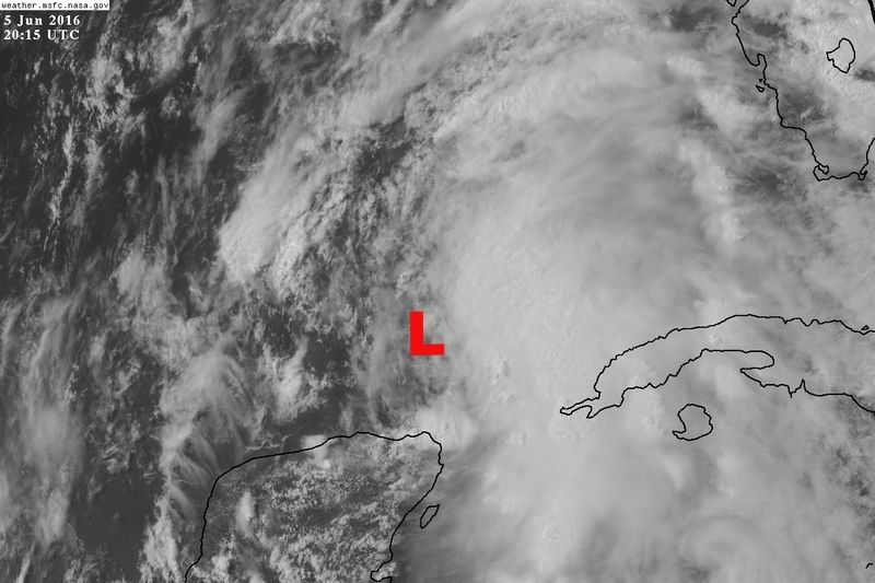
Kind of curious why they turned away from the heaviest convection and didn't sample it.
0 likes
Tropicwatch
Agnes 72', Eloise 75, Elena 85', Kate 85', Charley 86', Florence 88', Beryl 94', Dean 95', Erin 95', Opal 95', Earl 98', Georges 98', Ivan 2004', Arlene 2005', Dennis 2005', Ida 2009' Debby 2012' Irma 2017' Michael 2018'
Agnes 72', Eloise 75, Elena 85', Kate 85', Charley 86', Florence 88', Beryl 94', Dean 95', Erin 95', Opal 95', Earl 98', Georges 98', Ivan 2004', Arlene 2005', Dennis 2005', Ida 2009' Debby 2012' Irma 2017' Michael 2018'
Re: ATL: THREE - Tropical Depression - Discussion
Hammy wrote:SeGaBob wrote:Does anyone think it'll get upgraded at 5pm?
Highly doubtful--they seem to be avoiding going into the strongest area so we're only getting sampling of the weaker winds. They'll probably wait until the strongest winds are either closer to the center or actually in the Gulf of Mexico before naming it.
That ASCAT pass may be enough. If not they may wait until 8 or 11 for recon to finish up the sampling.
0 likes
-
northjaxpro

- S2K Supporter
- Posts: 8900
- Joined: Mon Sep 27, 2010 11:21 am
- Location: Jacksonville, FL
Re: ATL: THREE - Tropical Depression - Discussion
SeGaBob wrote:Does anyone think it'll get upgraded at 5pm?
Not yet in my view. No change at 5:00. NHC is waiting for Recon to find TS winds around a more dominant surface reflection, which has yet to be established. I am thinking maybe by the 11:00 p.m. tonight is when they will officially be able to determine a dominant LLC. If it occurs sooner, they will issue a special statement or advisory to name it Colin when it is warranted.
0 likes
NEVER, EVER SAY NEVER in the tropics and weather in general, and most importantly, with life itself!!
________________________________________________________________________________________
Fay 2008 Beryl 2012 Debby 2012 Colin 2016 Hermine 2016 Julia 2016 Matthew 2016 Irma 2017 Dorian 2019
________________________________________________________________________________________
Fay 2008 Beryl 2012 Debby 2012 Colin 2016 Hermine 2016 Julia 2016 Matthew 2016 Irma 2017 Dorian 2019

Re: ATL: THREE - Tropical Depression - Discussion
tolakram wrote:chaser1 wrote:NDG wrote:S-SSW winds is that the Recon is finding just to the west of the MLC, so nothing at the surface just yet underneath the MLC.
Exactly why I would've held off on an upgrade to T.D. Evidence of a sharp trough at the surface but no west winds. Meanwhile, with present upper level shear and limited banding or convection, I'd be remiss to label the broad surface low to the north as Depression either. Will a singular point that more clearly fits the definition of a T.D. form? I'd guess probably but not quite yet. If and when it does though, will quite possibly be at a point a bit east and south of the advisory
I think the working opinion is they upgraded in order to place warnings, not because they were certain there was an LLC. Next year they won't have to upgrade to warn. Their primary mission is to protect the public and in my opinion this was a good call, even though technically I think you are correct.
Agreed. For years this has been a complex dance playing out between a need to refine the science, then publically define the science, while at the same time protecting the public in the process.
0 likes
Andy D
(For official information, please refer to the NHC and NWS products.)
(For official information, please refer to the NHC and NWS products.)
Re: ATL: THREE - Tropical Depression - Discussion
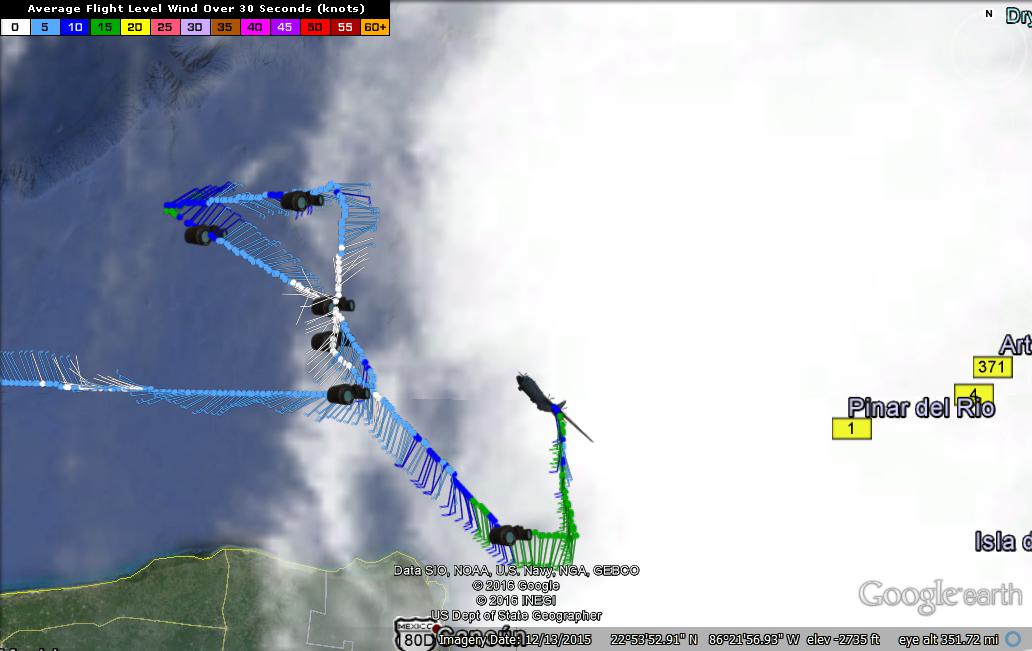
I think I see the surface low getting a bit closer now to the convection and MLC.
Last edited by NDG on Sun Jun 05, 2016 3:42 pm, edited 1 time in total.
0 likes
-
cycloneye
- Admin
- Posts: 149418
- Age: 69
- Joined: Thu Oct 10, 2002 10:54 am
- Location: San Juan, Puerto Rico
Re: ATL: THREE - Recon
URNT15 KNHC 052033
AF307 0103A CYCLONE HDOB 31 20160605
202400 2228N 08608W 9664 00355 0064 +227 +215 175013 013 018 001 00
202430 2230N 08609W 9664 00355 0064 +229 +212 178013 014 022 001 00
202500 2231N 08609W 9663 00356 0064 +224 +216 174015 015 022 003 00
202530 2233N 08610W 9665 00354 0065 +218 +217 173016 016 025 007 00
202600 2234N 08610W 9664 00355 0065 +218 +215 176016 016 027 006 00
202630 2236N 08611W 9664 00355 0065 +220 +216 171016 017 027 004 03
202700 2238N 08611W 9663 00356 0065 +219 +217 180016 017 027 004 00
202730 2239N 08611W 9664 00355 0065 +220 +217 185016 017 027 004 00
202800 2241N 08610W 9665 00355 0067 +217 //// 188016 016 028 004 01
202830 2243N 08610W 9663 00356 0067 +220 +220 179015 015 027 004 00
202900 2244N 08610W 9666 00354 0067 +219 //// 177013 014 028 007 01
202930 2246N 08609W 9662 00356 0066 +222 +222 170017 019 027 007 00
203000 2248N 08609W 9665 00358 0068 +222 //// 167017 019 028 008 01
203030 2249N 08609W 9668 00354 0068 +223 //// 154014 017 030 008 01
203100 2251N 08609W 9665 00356 0069 +223 +223 143014 015 032 011 00
203130 2253N 08608W 9656 00360 0066 +211 //// 149017 018 031 011 05
203200 2254N 08609W 9667 00353 0068 +223 +223 151016 017 029 006 00
203230 2256N 08610W 9664 00354 0065 +226 //// 148015 017 028 007 01
203300 2257N 08611W 9664 00353 0063 +224 //// 154014 015 023 006 01
203330 2259N 08612W 9664 00351 //// +222 //// 153014 014 022 003 01
0 likes
Visit the Caribbean-Central America Weather Thread where you can find at first post web cams,radars
and observations from Caribbean basin members Click Here
and observations from Caribbean basin members Click Here
-
cycloneye
- Admin
- Posts: 149418
- Age: 69
- Joined: Thu Oct 10, 2002 10:54 am
- Location: San Juan, Puerto Rico
Re: ATL: THREE - Recon

0 likes
Visit the Caribbean-Central America Weather Thread where you can find at first post web cams,radars
and observations from Caribbean basin members Click Here
and observations from Caribbean basin members Click Here
Re: ATL: THREE - Tropical Depression - Discussion
northjaxpro wrote:SeGaBob wrote:Does anyone think it'll get upgraded at 5pm?
Not yet in my view. No change at 5:00. NHC is waiting for Recon to find TS winds around a more dominant surface reflection, which has yet to be established. I am thinking maybe by the 11:00 p.m. tonight is when they will officially be able to determine a dominant LLC. If it occurs sooner, they will issue a special statement or advisory to name it Colin when it is warranted.
I'm even leaning toward thinking no upgrade will occur before tomorrow morning.
0 likes
Andy D
(For official information, please refer to the NHC and NWS products.)
(For official information, please refer to the NHC and NWS products.)
-
cycloneye
- Admin
- Posts: 149418
- Age: 69
- Joined: Thu Oct 10, 2002 10:54 am
- Location: San Juan, Puerto Rico
Re: ATL: THREE - Recon
URNT15 KNHC 052043
AF307 0103A CYCLONE HDOB 32 20160605
203400 2300N 08613W 9664 00353 //// +221 //// 156014 015 021 003 01
203430 2300N 08613W 9664 00353 0063 +220 +219 154014 014 022 002 01
203500 2303N 08614W 9664 00353 0063 +220 +217 151012 014 021 003 01
203530 2305N 08615W 9663 00354 0062 +221 +209 151012 013 022 004 00
203600 2306N 08616W 9666 00351 0062 +222 +208 147011 012 022 005 00
203630 2307N 08617W 9664 00350 0060 +224 +216 145011 011 022 004 00
203700 2309N 08618W 9663 00351 0059 +228 +222 134012 012 019 005 00
203730 2310N 08619W 9665 00349 0058 +230 +221 128011 012 021 005 00
203800 2312N 08619W 9663 00350 0058 +227 +221 124013 015 022 004 00
203830 2313N 08620W 9664 00350 0058 +225 +219 117015 015 023 006 00
203900 2315N 08621W 9663 00349 0057 +225 +224 115016 017 022 006 00
203930 2316N 08622W 9664 00348 0057 +225 +223 119018 018 022 006 00
204000 2318N 08623W 9664 00348 0056 +225 +215 119018 018 022 006 00
204030 2319N 08624W 9664 00348 0056 +225 +219 120018 018 021 006 00
204100 2320N 08625W 9663 00348 0055 +225 +221 121019 020 022 006 00
204130 2322N 08626W 9666 00345 0055 +226 +217 131016 019 021 004 00
204200 2323N 08627W 9663 00348 0054 +228 +214 138015 015 020 004 00
204230 2325N 08628W 9664 00345 0054 +227 +213 137016 016 022 003 00
204300 2326N 08629W 9664 00345 0054 +229 +207 138016 016 021 002 00
204330 2328N 08629W 9663 00347 0054 +226 +208 139016 016 020 003 00
0 likes
Visit the Caribbean-Central America Weather Thread where you can find at first post web cams,radars
and observations from Caribbean basin members Click Here
and observations from Caribbean basin members Click Here
-
cycloneye
- Admin
- Posts: 149418
- Age: 69
- Joined: Thu Oct 10, 2002 10:54 am
- Location: San Juan, Puerto Rico
Re: ATL: THREE - Recon

0 likes
Visit the Caribbean-Central America Weather Thread where you can find at first post web cams,radars
and observations from Caribbean basin members Click Here
and observations from Caribbean basin members Click Here
-
northjaxpro
- S2K Supporter
- Posts: 8900
- Joined: Mon Sep 27, 2010 11:21 am
- Location: Jacksonville, FL
Re: ATL: THREE - Tropical Depression - Discussion
chaser1 wrote:northjaxpro wrote:SeGaBob wrote:Does anyone think it'll get upgraded at 5pm?
Not yet in my view. No change at 5:00. NHC is waiting for Recon to find TS winds around a more dominant surface reflection, which has yet to be established. I am thinking maybe by the 11:00 p.m. tonight is when they will officially be able to determine a dominant LLC. If it occurs sooner, they will issue a special statement or advisory to name it Colin when it is warranted.
I'm even leaning toward thinking no upgrade will occur before tomorrow morning.
It is possible chaser1. As we typically see with these large monsoonal gyres, it can take quite awhile for these systems to pull together. I think sometime overnight Recon will be able to find a dominant LLC and declare it Colin.
0 likes
NEVER, EVER SAY NEVER in the tropics and weather in general, and most importantly, with life itself!!
________________________________________________________________________________________
Fay 2008 Beryl 2012 Debby 2012 Colin 2016 Hermine 2016 Julia 2016 Matthew 2016 Irma 2017 Dorian 2019
________________________________________________________________________________________
Fay 2008 Beryl 2012 Debby 2012 Colin 2016 Hermine 2016 Julia 2016 Matthew 2016 Irma 2017 Dorian 2019
Who is online
Users browsing this forum: No registered users and 21 guests