Texas Spring 2026

U.S. & Caribbean Weather Discussions and Severe Weather Events

Moderator: S2k Moderators

Forum rules

The posts in this forum are NOT official forecast and should not be used as such. They are just the opinion of the poster and may or may not be backed by sound meteorological data. They are NOT endorsed by any professional institution or STORM2K.

Help Support Storm2K
Message
Author
User avatar
wxman22
Category 5
Category 5
Posts: 1959
Joined: Mon Jan 30, 2006 12:39 am
Location: Wichita Falls, TX
Contact:

Re: Texas Spring 2026

#501 Postby wxman22 » Fri Apr 03, 2026 2:23 pm

That’s a large severe thunderstorm watch.

Image

Severe Thunderstorm Watch Number 93
NWS Storm Prediction Center Norman OK
240 PM CDT Fri Apr 3 2026

The NWS Storm Prediction Center has issued a

* Severe Thunderstorm Watch for portions of
Eastern Kansas
Western Missouri
Central Oklahoma
Western North Texas

* Effective this Friday afternoon and evening from 240 PM until
1000 PM CDT.

* Primary threats include...
Scattered large hail and isolated very large hail events to 3
inches in diameter likely
Scattered damaging wind gusts to 70 mph likely
A tornado or two possible

SUMMARY...Thunderstorms will intensify through the afternoon along a
cold front from western Oklahoma into eastern Kansas. Large hail
and damaging wind gusts will be possible with this activity. A
tornado or two is also possible.

The severe thunderstorm watch area is approximately along and 85
statute miles east and west of a line from 40 miles southwest of
Wichita Falls TX to 55 miles northeast of Kansas City MO. For a
complete depiction of the watch see the associated watch outline
update (WOUS64 KWNS WOU3).
Last edited by wxman22 on Fri Apr 03, 2026 2:49 pm, edited 2 times in total.
0 likes   

Stratton23
Category 5
Category 5
Posts: 3564
Joined: Fri Jul 21, 2023 10:59 pm
Location: Katy, Tx

Re: Texas Spring 2026

#502 Postby Stratton23 » Fri Apr 03, 2026 2:34 pm

Looks like the majority of rains over the next 2 weeks looks to be focused in north and ne texas, how unfortunate, but also not surprising at all
0 likes   

HockeyTx82
S2K Supporter
S2K Supporter
Posts: 2799
Joined: Tue Oct 27, 2009 11:17 am
Location: Ponder, TX

Re: Texas Spring 2026

#503 Postby HockeyTx82 » Fri Apr 03, 2026 3:11 pm

wxman22 wrote:That’s a large severe thunderstorm watch.

https://i.postimg.cc/x8dQDFbm/IMG-0735.gif

Severe Thunderstorm Watch Number 93
NWS Storm Prediction Center Norman OK
240 PM CDT Fri Apr 3 2026

The NWS Storm Prediction Center has issued a

* Severe Thunderstorm Watch for portions of
Eastern Kansas
Western Missouri
Central Oklahoma
Western North Texas

* Effective this Friday afternoon and evening from 240 PM until
1000 PM CDT.

* Primary threats include...
Scattered large hail and isolated very large hail events to 3
inches in diameter likely
Scattered damaging wind gusts to 70 mph likely
A tornado or two possible

SUMMARY...Thunderstorms will intensify through the afternoon along a
cold front from western Oklahoma into eastern Kansas. Large hail
and damaging wind gusts will be possible with this activity. A
tornado or two is also possible.

The severe thunderstorm watch area is approximately along and 85
statute miles east and west of a line from 40 miles southwest of
Wichita Falls TX to 55 miles northeast of Kansas City MO. For a
complete depiction of the watch see the associated watch outline
update (WOUS64 KWNS WOU3).


Yes I was thinking the same, that is a really large watch.
0 likes   
Don't hold me accountable for anything I post on this forum. Leave the real forecasting up to the professionals.

Location: Ponder, TX (all observation posts are this location unless otherwise noted)

User avatar
Edwards Limestone
S2K Supporter
S2K Supporter
Posts: 513
Age: 36
Joined: Tue Dec 28, 2021 11:05 am
Location: Smithson Valley, TX

Re: Texas Spring 2026

#504 Postby Edwards Limestone » Fri Apr 03, 2026 5:14 pm

Stratton23 wrote:Looks like the majority of rains over the next 2 weeks looks to be focused in north and ne texas, how unfortunate, but also not surprising at all


Yup, same story as always. At least someone is getting much needed rain.
0 likes   
The above post is NOT an official forecast and should not be used as such. It is just the opinion of the poster and may or may not be backed by sound meteorological data. It is NOT endorsed by any professional institution including Storm2k. For official information, please refer to NWS products.

User avatar
txtwister78
Category 5
Category 5
Posts: 2208
Joined: Wed Jan 30, 2019 12:56 pm
Location: San Antonio

Re: Texas Spring 2026

#505 Postby txtwister78 » Fri Apr 03, 2026 5:40 pm

Stratton23 wrote:Looks like the majority of rains over the next 2 weeks looks to be focused in north and ne texas, how unfortunate, but also not surprising at all


Not seeing that at all? Ensembles and CPC remain bullish for a good portion of the state so curious what you're basing that conclusion on
0 likes   

User avatar
txtwister78
Category 5
Category 5
Posts: 2208
Joined: Wed Jan 30, 2019 12:56 pm
Location: San Antonio

Re: Texas Spring 2026

#506 Postby txtwister78 » Fri Apr 03, 2026 5:44 pm

Edwards Limestone wrote:
Stratton23 wrote:Looks like the majority of rains over the next 2 weeks looks to be focused in north and ne texas, how unfortunate, but also not surprising at all


Yup, same story as always. At least someone is getting much needed rain.


Not really my friend. Totally different pattern ahead. Not going to happen all at once. Hang in there...lol
1 likes   

User avatar
South Texas Storms
Professional-Met
Professional-Met
Posts: 4260
Joined: Thu Jun 24, 2010 12:28 am
Location: Houston, TX

Re: Texas Spring 2026

#507 Postby South Texas Storms » Fri Apr 03, 2026 5:47 pm

txtwister78 wrote:
Stratton23 wrote:Looks like the majority of rains over the next 2 weeks looks to be focused in north and ne texas, how unfortunate, but also not surprising at all


Not seeing that at all? Ensembles and CPC remain bullish for a good portion of the state so curious what you're basing that conclusion on


Yeah the pattern looks great over the next few weeks across much of the state. We should see multiple opportunities to see some beneficial rainfall for the foreseeable future. The latest ensembles are in general agreement in showing widespread 2-4 inches over the next 2 weeks.
2 likes   

User avatar
txtwister78
Category 5
Category 5
Posts: 2208
Joined: Wed Jan 30, 2019 12:56 pm
Location: San Antonio

Re: Texas Spring 2026

#508 Postby txtwister78 » Fri Apr 03, 2026 6:12 pm

South Texas Storms wrote:
txtwister78 wrote:
Stratton23 wrote:Looks like the majority of rains over the next 2 weeks looks to be focused in north and ne texas, how unfortunate, but also not surprising at all


Not seeing that at all? Ensembles and CPC remain bullish for a good portion of the state so curious what you're basing that conclusion on


Yeah the pattern looks great over the next few weeks across much of the state. We should see multiple opportunities to see some beneficial rainfall for the foreseeable future. The latest ensembles are in general agreement in showing widespread 2-4 inches over the next 2 weeks.


Agreed. I thought I was missing something. Lol. Looks pretty good to me as well especially when you see that show up across all ensemble guidance as you mentioned. Bring it
1 likes   

User avatar
Iceresistance
Category 5
Category 5
Posts: 9594
Age: 22
Joined: Sat Oct 10, 2020 9:45 am
Location: Tecumseh, OK/Norman, OK

Re: Texas Spring 2026

#509 Postby Iceresistance » Fri Apr 03, 2026 10:16 pm

This storm is crazy sheesh

I was under the tornado warning earlier, but it missed me to the north
0 likes   
Bill 2015 & Beta 2020

Winter 2020-2021 :cold:

All observations are in Tecumseh, OK unless otherwise noted.

Winter posts are focused mainly for Oklahoma & Texas.

Take any of my forecasts with a grain of salt, refer to the NWS, SPC, and NHC for official information

Never say Never with weather! Because ANYTHING is possible!

HockeyTx82
S2K Supporter
S2K Supporter
Posts: 2799
Joined: Tue Oct 27, 2009 11:17 am
Location: Ponder, TX

Re: Texas Spring 2026

#510 Postby HockeyTx82 » Fri Apr 03, 2026 10:19 pm

Quite the storm passing through central Oklahoma
0 likes   
Don't hold me accountable for anything I post on this forum. Leave the real forecasting up to the professionals.

Location: Ponder, TX (all observation posts are this location unless otherwise noted)

User avatar
ElectricStorm
Category 5
Category 5
Posts: 5148
Age: 25
Joined: Tue Aug 13, 2019 11:23 pm
Location: Norman, OK

Re: Texas Spring 2026

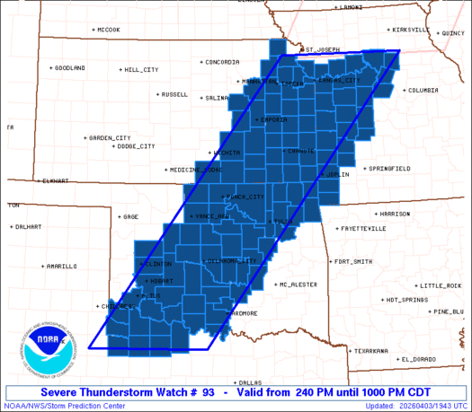
#511 Postby ElectricStorm » Fri Apr 03, 2026 10:33 pm

Much more potent than that underwhelming QLCS a couple days ago. New discrete cell near Ada could be a problem.

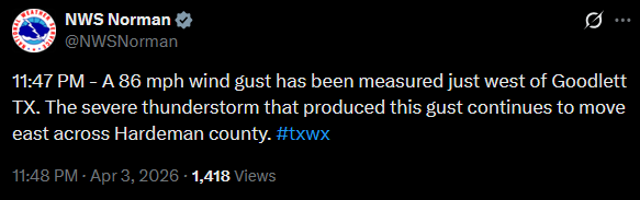
Slight risk days seem to produce quite a bit around here compared to some higher-end days lol

Late next week into next weekend could get interesting, long ways out but early guidance is suggesting the possibility for multiple severe weather days around that time.
2 likes   
B.S Meteorology, University of Oklahoma '25

Please refer to the NHC, NWS, or SPC for official information.

Brent
S2K Supporter
S2K Supporter
Posts: 38759
Age: 37
Joined: Sun May 16, 2004 10:30 pm
Location: Tulsa Oklahoma
Contact:

Re: Texas Spring 2026

#512 Postby Brent » Fri Apr 03, 2026 11:34 pm

Looks like there was apparently 90 mph winds or maybe even a weak tornado in OKC earlier
1 likes   
#neversummer

User avatar
wxman22
Category 5
Category 5
Posts: 1959
Joined: Mon Jan 30, 2006 12:39 am
Location: Wichita Falls, TX
Contact:

Re: Texas Spring 2026

#513 Postby wxman22 » Sat Apr 04, 2026 2:05 am

This squall line has a lot of wind energy. Its packing a punch right now winds been gusting up to 60 mph here for almost 20 mins now. An 86 mph wind gust was reported near Quanah.

Image
1 likes   

Brent
S2K Supporter
S2K Supporter
Posts: 38759
Age: 37
Joined: Sun May 16, 2004 10:30 pm
Location: Tulsa Oklahoma
Contact:

Re: Texas Spring 2026

#514 Postby Brent » Sat Apr 04, 2026 3:54 am

Definitely a tornado near Shawnee east of OKC

Down to 52 degrees here :double: again this weekend is looking colder than Christmas weekend :spam:
0 likes   
#neversummer

User avatar
Iceresistance
Category 5
Category 5
Posts: 9594
Age: 22
Joined: Sat Oct 10, 2020 9:45 am
Location: Tecumseh, OK/Norman, OK

Re: Texas Spring 2026

#515 Postby Iceresistance » Sat Apr 04, 2026 8:02 am

Rain gauge said 3.3 inches of rain, wettest night in years
1 likes   
Bill 2015 & Beta 2020

Winter 2020-2021 :cold:

All observations are in Tecumseh, OK unless otherwise noted.

Winter posts are focused mainly for Oklahoma & Texas.

Take any of my forecasts with a grain of salt, refer to the NWS, SPC, and NHC for official information

Never say Never with weather! Because ANYTHING is possible!

User avatar
wxman22
Category 5
Category 5
Posts: 1959
Joined: Mon Jan 30, 2006 12:39 am
Location: Wichita Falls, TX
Contact:

Re: Texas Spring 2026

#516 Postby wxman22 » Sat Apr 04, 2026 9:27 am

Received around 2 inches here.Bringing the total to over 4 inches for the week. :)
1 likes   

User avatar
Ntxw
Storm2k Moderator
Storm2k Moderator
Posts: 23514
Joined: Wed Oct 21, 2009 6:34 pm
Location: DFW, Texas

Re: Texas Spring 2026

#517 Postby Ntxw » Sat Apr 04, 2026 10:47 am

Over 2" of rain at DFW in another morning event, now 54F. Another beautiful day!
2 likes   
The above post and any post by Ntxw is NOT an official forecast and should not be used as such. It is just the opinion of the poster and may or may not be backed by sound meteorological data. It is NOT endorsed by any professional institution including Storm2k. For official information, please refer to NWS products.

  Help support Storm2K!
Help Support Storm2K


Return to “USA & Caribbean Weather”

Who is online

Users browsing this forum: Cpv17, Iceresistance, South Texas Storms, wxman22 and 104 guests