
Frequent thunder.
Moderator: S2k Moderators


000
FXUS62 KMFL 201857
AFDMFL
AREA FORECAST DISCUSSION
NATIONAL WEATHER SERVICE MIAMI FL
257 PM EDT MON JUL 20 2009
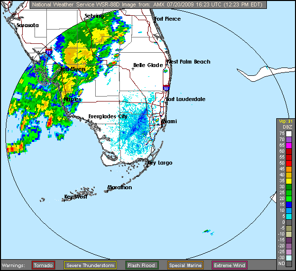
...HEAVY RAINFALL POSSIBLE TUESDAY NIGHT INTO WEDNESDAY NIGHT...
...THE LATEST SHORT RANGE MODELS ARE SHOWING THAT A UPPER LEVEL LOW
WILL DEVELOP IN THE THROUGH OF LOW PRESSURE OVER THE EASTERN GULF
OF MEXICO...AND DRIFT NORTHEAST ACROSS CENTRAL FLORIDA TUESDAY
THROUGH WEDNESDAY NIGHT. AT THE SAME TIME...THE NORTHERN PORTION
OF THE TROPICAL WAVE OVER THE CENTRAL BAHAMA ISLANDS WILL MOVE
NORTHWEST AND THROUGH SOUTH FLORIDA TUESDAY NIGHT. ANOTHER
TROPICAL WAVE OVER THE WINDWARD AND LEEWARD ISLAND WILL ALSO MOVE
NORTHWEST AND THROUGH SOUTH FLORIDA WEDNESDAY NIGHT. THIS WILL
KEEP THE SOUTHERLY WIND FLOW OVER THE CWA...AND ALLOW FOR DEEP
TROPICAL MOISTURE TO WORK INTO SOUTH FLORIDA FROM THE CARIBBEAN
SEA DURING THE NEXT 48 HOURS. RAINFALL AMOUNTS FROM THESE TROPICAL
WAVES WILL BE DISCUSS IN THE HYDROLOGY SECTION BELOW...
...
&&
.HYDROLOGY...
RAINFALL AMOUNTS OVER SOUTH FLORIDA FOR THE NEXT 48 HOURS...DUE
TO THE TWO TROPICAL WAVES AND THE UPPER LEVEL LOW MOVING ACROSS
CENTRAL FLORIDA...WILL RANGE FROM 1 TO 3 INCHES ON THE WEST COAST
METRO AREAS TO 2 TO 4 INCHES OVER THE EAST COAST METRO AREAS. SOME
ISOLATED AREAS COULD EVEN SEE BETWEEN 3 TO 5 INCHES OF RAINFALL
WITH THE HEAVIEST THUNDERSTORMS. THE PWAT VALUES WILL ALSO BE
ABOUT 2 INCHES STARTING TUESDAY NIGHT INTO WEDNESDAY NIGHT. SO
WILL MENTION HEAVY RAINFALL POSSIBLE TUESDAY NIGHT THROUGH
WEDNESDAY NIGHT IN THE ZONES.

artist wrote:interesting bit from the Miami NWS Forecast Discussion-
(never seen them include a hydrology forecast before)000
FXUS62 KMFL 201857
AFDMFL
AREA FORECAST DISCUSSION
NATIONAL WEATHER SERVICE MIAMI FL
257 PM EDT MON JUL 20 2009
...HEAVY RAINFALL POSSIBLE TUESDAY NIGHT INTO WEDNESDAY NIGHT...
...THE LATEST SHORT RANGE MODELS ARE SHOWING THAT A UPPER LEVEL LOW
WILL DEVELOP IN THE THROUGH OF LOW PRESSURE OVER THE EASTERN GULF
OF MEXICO...AND DRIFT NORTHEAST ACROSS CENTRAL FLORIDA TUESDAY
THROUGH WEDNESDAY NIGHT. AT THE SAME TIME...THE NORTHERN PORTION
OF THE TROPICAL WAVE OVER THE CENTRAL BAHAMA ISLANDS WILL MOVE
NORTHWEST AND THROUGH SOUTH FLORIDA TUESDAY NIGHT. ANOTHER
TROPICAL WAVE OVER THE WINDWARD AND LEEWARD ISLAND WILL ALSO MOVE
NORTHWEST AND THROUGH SOUTH FLORIDA WEDNESDAY NIGHT. THIS WILL
KEEP THE SOUTHERLY WIND FLOW OVER THE CWA...AND ALLOW FOR DEEP
TROPICAL MOISTURE TO WORK INTO SOUTH FLORIDA FROM THE CARIBBEAN
SEA DURING THE NEXT 48 HOURS. RAINFALL AMOUNTS FROM THESE TROPICAL
WAVES WILL BE DISCUSS IN THE HYDROLOGY SECTION BELOW...
...
&&
.HYDROLOGY...
RAINFALL AMOUNTS OVER SOUTH FLORIDA FOR THE NEXT 48 HOURS...DUE
TO THE TWO TROPICAL WAVES AND THE UPPER LEVEL LOW MOVING ACROSS
CENTRAL FLORIDA...WILL RANGE FROM 1 TO 3 INCHES ON THE WEST COAST
METRO AREAS TO 2 TO 4 INCHES OVER THE EAST COAST METRO AREAS. SOME
ISOLATED AREAS COULD EVEN SEE BETWEEN 3 TO 5 INCHES OF RAINFALL
WITH THE HEAVIEST THUNDERSTORMS. THE PWAT VALUES WILL ALSO BE
ABOUT 2 INCHES STARTING TUESDAY NIGHT INTO WEDNESDAY NIGHT. SO
WILL MENTION HEAVY RAINFALL POSSIBLE TUESDAY NIGHT THROUGH
WEDNESDAY NIGHT IN THE ZONES.


Extremeweatherguy wrote:Pretty cool picture I found on the News Channel 13 website...
http://www.cfnews13.com/uploadedImages/Stories/Weather/Local_Weather_Headlines/Ormond%20Funnel%20Cloud%20(Danny%20Phillips).jpg
fact789 wrote:I dont see that storm having any 40 mph winds. All its done here is interrupt pool time. XD

Return to “USA & Caribbean Weather”
Users browsing this forum: No registered users and 58 guests


.jpg)