Texas Winter 2013-2014
Moderator: S2k Moderators
Forum rules
 The posts in this forum are NOT official forecast and should not be used as such. They are just the opinion of the poster and may or may not be backed by sound meteorological data. They are NOT endorsed by any professional institution or STORM2K.

The posts in this forum are NOT official forecast and should not be used as such. They are just the opinion of the poster and may or may not be backed by sound meteorological data. They are NOT endorsed by any professional institution or STORM2K.

-
horselattitudesfarm

- Category 1

- Posts: 315
- Joined: Thu Jul 16, 2009 5:55 pm
- Location: Asheville, NC (formerly from Dallas, TX)
Re: Texas Winter 2013-2014
I have moved from the DFW area to western North Carolina and , wow!, what a difference 900 miles to the east makes. We are living under that huge trough and have had lows of 0 degrees a couple of times now. The ponds are frozen over and even the streams and rivers are getting sheets of ice on the edges. The weather here is very dynamic and changes much quicker than what I've seen in Dallas the last few years. The mountains seem to block some of the snow and cold that has been hitting the Ohio valley and places only 100 miles to our north are getting lots more snow.
0 likes

Re: Texas Winter 2013-2014
horselattitudesfarm wrote:I have moved from the DFW area to western North Carolina and , wow!, what a difference 900 miles to the east makes. We are living under that huge trough and have had lows of 0 degrees a couple of times now. The ponds are frozen over and even the streams and rivers are getting sheets of ice on the edges. The weather here is very dynamic and changes much quicker than what I've seen in Dallas the last few years. The mountains seem to block some of the snow and cold that has been hitting the Ohio valley and places only 100 miles to our north are getting lots more snow.
Of course it would be
0 likes
The above post and any post by Ntxw is NOT an official forecast and should not be used as such. It is just the opinion of the poster and may or may not be backed by sound meteorological data. It is NOT endorsed by any professional institution including Storm2k. For official information, please refer to NWS products.
Help support Storm2K!
Re: Texas Winter 2013-2014
The NAM and CMC seems to be the two wanting to kick things out while Euro, GFS, and Ukmet says nuh uh keeping it stuck in the baja and dry cold.
0 likes
The above post and any post by Ntxw is NOT an official forecast and should not be used as such. It is just the opinion of the poster and may or may not be backed by sound meteorological data. It is NOT endorsed by any professional institution including Storm2k. For official information, please refer to NWS products.
Help support Storm2K!
Help support Storm2K!
-
wxman57

- Moderator-Pro Met

- Posts: 23174
- Age: 68
- Joined: Sat Jun 21, 2003 8:06 pm
- Location: Houston, TX (southwest)
Re: Texas Winter 2013-2014
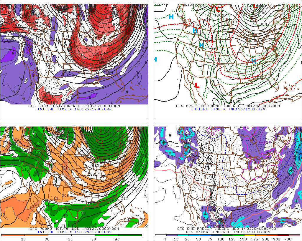
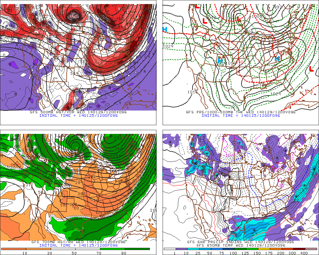
Overnight GFS is still quite dry for TX on Tue/Wed. Just cold and dry. NAM is trending that way. I do like the GFS forecast of low to mid 70s next weekend.
0 likes
Re: Texas Winter 2013-2014
wxman57 wrote:Overnight GFS is still quite dry for TX on Tue/Wed. Just cold and dry. NAM is trending that way. I do like the GFS forecast of low to mid 70s next weekend.
On a serious note, what do you think of the ECMWF/GEFS ensemble shuffling the ridging and longwave pattern to -EPO/-PNA?
0 likes
The above post and any post by Ntxw is NOT an official forecast and should not be used as such. It is just the opinion of the poster and may or may not be backed by sound meteorological data. It is NOT endorsed by any professional institution including Storm2k. For official information, please refer to NWS products.
Help support Storm2K!
Help support Storm2K!
-
wxman57
- Moderator-Pro Met
- Posts: 23174
- Age: 68
- Joined: Sat Jun 21, 2003 8:06 pm
- Location: Houston, TX (southwest)
Re: Texas Winter 2013-2014
Ntxw wrote:wxman57 wrote:Overnight GFS is still quite dry for TX on Tue/Wed. Just cold and dry. NAM is trending that way. I do like the GFS forecast of low to mid 70s next weekend.
On a serious note, what do you think of the ECMWF/GEFS ensemble shuffling the ridging and longwave pattern to -EPO/-PNA?
I think the first 90F day is looking like it won't occur in February...
0 likes
One can still dream, 1986 
0 likes
The above post and any post by Ntxw is NOT an official forecast and should not be used as such. It is just the opinion of the poster and may or may not be backed by sound meteorological data. It is NOT endorsed by any professional institution including Storm2k. For official information, please refer to NWS products.
Help support Storm2K!
Help support Storm2K!
-
Portastorm

- Storm2k Moderator

- Posts: 9955
- Age: 63
- Joined: Fri Jul 11, 2003 9:16 am
- Location: Round Rock, TX
- Contact:
Re: Texas Winter 2013-2014
wxman57 wrote:Overnight GFS is still quite dry for TX on Tue/Wed. Just cold and dry. NAM is trending that way. I do like the GFS forecast of low to mid 70s next weekend.
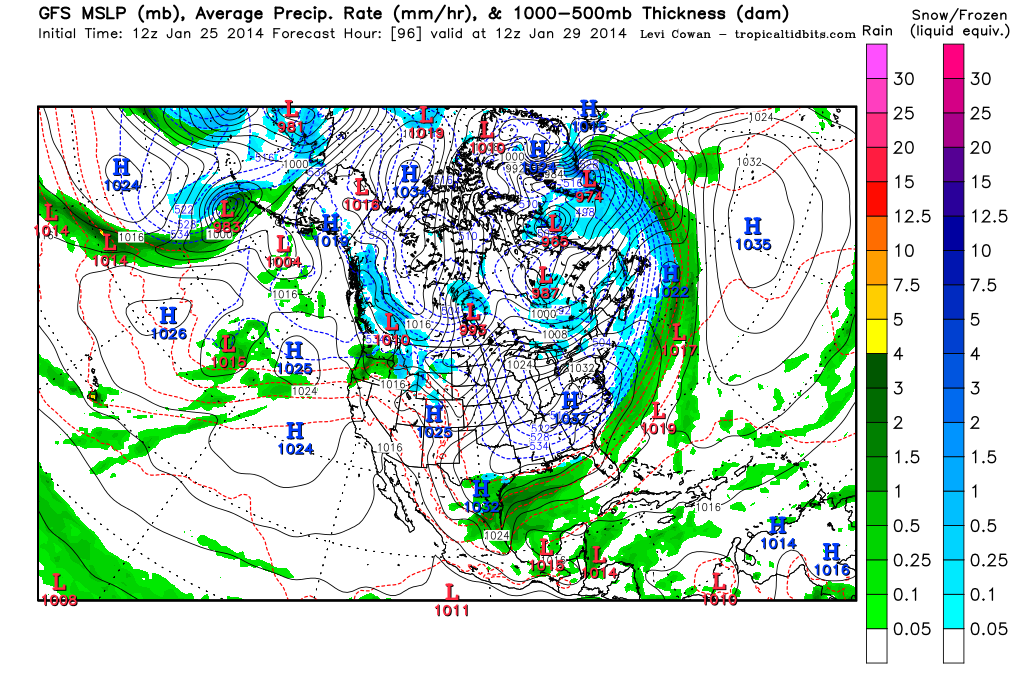
Let's see how you like the 3z SREF, the one showing anywhere from .50 to 1.25 QPF from Waco down I-35 to San Antonio to Laredo, over to Corpus and back to Houston, and up to Lufkin. In fact, it suggests another wintry slop mess for portions of central and south central Texas.

Uploaded with ImageShack.us
0 likes
Any forecasts under my name are to be taken with a grain of salt. Get your best forecasts from the National Weather Service and National Hurricane Center.

6z GFS has freezing rain, sleet, and some snow for most of south Texas beginning Tuesday morning and ending Wednesday morning. Let's see if it, the CMC, and NAM hold serve on their respective 12z runs. In addition, let's see if the 12z Euro begins to pick up the shortwave rounding the base of the trough. This definitely bears watching.
0 likes
-
Portastorm
- Storm2k Moderator
- Posts: 9955
- Age: 63
- Joined: Fri Jul 11, 2003 9:16 am
- Location: Round Rock, TX
- Contact:
Re: Texas Winter 2013-2014
On a comment on the NAM per wxman57's earlier post ... it is looking drier overall if one compares the 12z run to the overnight 0z. However, for those that would get precip under the NAM (those along the Texas coast), the precip amounts are actually HEAVIER in the 12z compared to the 0z run. That means if the cold air can get there, you folks along the coast might be in for some winter fun.
The model looks to develop a coastal trough and it is trending further south with the upper level energy inbound from Mexico.
I would point out that I think the NAM performed poorly with this past "event." We never had a coastal trough develop like the NAM and the SREF, even, suggested. It was just a mild-looking upper level system with good Pacific inflow. And the Euro wasn't all that great either. Actually, the GFS did quite well. So at this point, I'm kinda leaning towards the colder/drier (for most of the state) GFS scenario. But the model trends this weekend will be followed closely at the PWC.
Who knows, North Texas had their Icemageddon, we in South Central Texas just had ours, maybe it's South Texas' turn this time. Whaddya say Big O, Rgv20, and cctxhurricanewatcher?
0 likes
Any forecasts under my name are to be taken with a grain of salt. Get your best forecasts from the National Weather Service and National Hurricane Center.
-
ThunderSleetDreams

- S2K Supporter

- Posts: 1510
- Age: 43
- Joined: Tue Dec 20, 2011 4:42 pm
- Location: S of Weimar, TX
Re: Texas Winter 2013-2014
wxman57 wrote:Ntxw wrote:wxman57 wrote:Overnight GFS is still quite dry for TX on Tue/Wed. Just cold and dry. NAM is trending that way. I do like the GFS forecast of low to mid 70s next weekend.
On a serious note, what do you think of the ECMWF/GEFS ensemble shuffling the ridging and longwave pattern to -EPO/-PNA?
I think the first 90F day is looking like it won't occur in February...
Probably won't in March either given the trend. Maybe April
0 likes
#NeverSummer
I hibernate when it gets above 75 degrees!
I hibernate when it gets above 75 degrees!
Re: Texas Winter 2013-2014
Portastorm wrote:On a comment on the NAM per wxman57's earlier post ... it is looking drier overall if one compares the 12z run to the overnight 0z. However, for those that would get precip under the NAM (those along the Texas coast), the precip amounts are actually HEAVIER in the 12z compared to the 0z run. That means if the cold air can get there, you folks along the coast might be in for some winter fun.
The model looks to develop a coastal trough and it is trending further south with the upper level energy inbound from Mexico.
I would point out that I think the NAM performed poorly with this past "event." We never had a coastal trough develop like the NAM and the SREF, even, suggested. It was just a mild-looking upper level system with good Pacific inflow. And the Euro wasn't all that great either. Actually, the GFS did quite well. So at this point, I'm kinda leaning towards the colder/drier (for most of the state) GFS scenario. But the model trends this weekend will be followed closely at the PWC.
Who knows, North Texas had their Icemageddon, we in South Central Texas just had ours, maybe it's South Texas' turn this time. Whaddya say Big O, Rgv20, and cctxhurricanewatcher?
I sure wouldn't mind that (understatement).

0 likes
-
CYCLONE MIKE
- Category 5

- Posts: 2183
- Joined: Tue Aug 31, 2004 6:04 pm
- Location: Gonzales, LA
Re: Texas Winter 2013-2014
Portastorm wrote:On a comment on the NAM per wxman57's earlier post ... it is looking drier overall if one compares the 12z run to the overnight 0z. However, for those that would get precip under the NAM (those along the Texas coast), the precip amounts are actually HEAVIER in the 12z compared to the 0z run. That means if the cold air can get there, you folks along the coast might be in for some winter fun.
The model looks to develop a coastal trough and it is trending further south with the upper level energy inbound from Mexico.
I would point out that I think the NAM performed poorly with this past "event." We never had a coastal trough develop like the NAM and the SREF, even, suggested. It was just a mild-looking upper level system with good Pacific inflow. And the Euro wasn't all that great either. Actually, the GFS did quite well. So at this point, I'm kinda leaning towards the colder/drier (for most of the state) GFS scenario. But the model trends this weekend will be followed closely at the PWC.
Agree 100%, said this a few times in "our" thread. The nam never had the ice and sleet making it into la until it was already obvious. Kept evaporating and pushing offshore west of lake charles. Gfs did much better for us than any of the other models. Dont have any idea aboutnthe cmc though as to what it showed.
The 6z gfs did show some winter weather trying to break out over us but keeps it right along the coast whereas last night run showed nothing.
0 likes
12z GFS no phase and lags baja low, still mostly dry
0 likes
The above post and any post by Ntxw is NOT an official forecast and should not be used as such. It is just the opinion of the poster and may or may not be backed by sound meteorological data. It is NOT endorsed by any professional institution including Storm2k. For official information, please refer to NWS products.
Help support Storm2K!
Help support Storm2K!
-
srainhoutx

- S2K Supporter
- Posts: 6919
- Age: 68
- Joined: Sun Jan 14, 2007 11:34 am
- Location: Haywood County, NC
- Contact:
Re: Texas Winter 2013-2014
The 12Z GFS has trended a bit stronger with the closed core upper air disturbance crossing Mexico early next week and is not cutting that feature off ~vs~ what it has been suggesting. A more progressive disturbance that continues moving E would tend to favor increased over running and precip developing after the Arctic air mass is firmly entrenched across our Region. There are also hints of yet another Coastal trough developing which further increases the odds that more wintry weather may well be possible, albeit light. We will see.
0 likes
Carla/Alicia/Jerry(In The Eye)/Michelle/Charley/Ivan/Dennis/Katrina/Rita/Wilma/Ike/Harvey
Member: National Weather Association
Wx Infinity Forums
http://wxinfinity.com/index.php
Facebook.com/WeatherInfinity
Twitter @WeatherInfinity
Member: National Weather Association
Wx Infinity Forums
http://wxinfinity.com/index.php
Facebook.com/WeatherInfinity
Twitter @WeatherInfinity
-
stormlover2013
Re: Texas Winter 2013-2014
I agree, and u also have to look at the trends!! Models don't get a good clamp on it until about 30 hours or so, so if this trend keeps it up then here we go!!
0 likes
-
timmeister

- Tropical Storm

- Posts: 191
- Age: 63
- Joined: Thu Jan 06, 2011 11:17 am
- Location: Hattiesburg, MS
Re: Texas Winter 2013-2014
Portastorm wrote:On a comment on the NAM per wxman57's earlier post ... it is looking drier overall if one compares the 12z run to the overnight 0z. However, for those that would get precip under the NAM (those along the Texas coast), the precip amounts are actually HEAVIER in the 12z compared to the 0z run. That means if the cold air can get there, you folks along the coast might be in for some winter fun.
The model looks to develop a coastal trough and it is trending further south with the upper level energy inbound from Mexico.
Here is an excerpt from the Area Forecast Discussion issued by the NWS Jackson MS that's in agreement with your analysis:
MONDAY THROUGH WEDNESDAY NIGHT...ALL GUIDANCE IS IN STRONG AGREEMENT
THAT FRIGID ARCTIC AIR WILL MAKE A RETURN TO THE ARKLAMISS FOR THE
EARLY TO MID WEEK...AND THERE ARE GROWING INDICATIONS THAT THE RISK
FOR AT LEAST LIGHT WINTRY PRECIPITATION IS ON THE INCREASE FOR AT
LEAST AREAS ALONG AND SOUTH OF THE I-20 CORRIDOR.
AS HAS BEEN THE CASE WITH MOST COLD FRONTS THIS WINTER SEASON...
EXPECT AN EARLY MORNING ARRIVAL FOR THE FRONT MONDAY. THIS WILL
MAKE TEMPERATURES TRICKY GIVEN THE STRONG MIXING THAT WILL TEND TO
NEGATE THE SURFACE COLD ADVECTION SOME INITIALLY IN THE
MORNING...ALTHOUGH THERE SHOULD BE MORE CLOUD POTENTIAL AND EVEN A
FEW SHOWERS ALONG/AHEAD OF THE FRONTTHIS TIME AROUND WHICH COULD
HASTEN THE COOLING TREND. FALLING TEMPERATURES ARE EXPECTED FOR THE
MOST PART MONDAY AFTERNOON WITH STRONGER COLD ADVECTION EXPECTED
MONDAY NIGHT THAT WILL LIKELY SEND TEMPERATURES INTO THE TEENS ALONG
THE HIGHWAY 82 CORRIDOR. THERE MAY BE GREATER FUNNELING OF THE COLD
AIR THROUGH THE UPPER DELTA REGION AND HAVE CUT TEMPERATURES THERE A
BIT. ON THE OTHER HAND...THICKER CLOUD COVER OVER SOUTHERN PORTIONS
OF THE ARKLAMISS COULD KEEP TEMPERATURES UP A LITTLE AND HAVE RAISED
GUIDANCE VALUES THERE.
A STRONG BAROCLINIC ZONE WILL SET UP ACROSS THE GULF COAST STATES AS
THE FRONT CONTINUES TO PUSH SOUTH. WHILE THE GFS/ECMWF ARE BEARISH
WITH PRECIPITATION POTENTIAL MONDAY NIGHT AND TUESDAY...A NUMBER OF
MODELS (GEM/GEFS/SREF/NAM) INDICATE JUST ENOUGH BACKING OF THE MID
LEVEL FLOW/ISENTROPIC UPGLIDE WILL HELP TO BREAK OUT PRECIPITATION
ACROSS THE REGION. WITH CONTINUED COLD ADVECTION...THIS PRECIPITATION
WOULD LIKELY BE IN THE FORM OF SNOW...ALTHOUGH THE NAM SHOWS A
PRONOUNCED WARM LAYER ALOFT THAT WOULD INCREASE THE ODDS FOR
FREEZING RAIN AND SLEET MONDAY NIGHT. ALL GUIDANCE INDICATE THE
COLUMN WOULD BE COLD ENOUGH FOR ALL SNOW TUESDAY...AND THE GEM AND
SEVERAL GEFS/SREF MEMBERS ACTUALLY INDICATE THE POTENTIAL FOR A FEW
INCHES OF SNOW. BUT GIVEN THAT THE BULK OF GUIDANCE IS ON THE DRY
SIDE...WILL KEEP POPS LOW FOR NOW.
WILL NEED TO CLOSELY WATCH FOR MORE DIGGING OF THE LONGWAVE TROUGH
AND GREATER ENERGY ROUNDING ITS BASE THAT COULD INCREASE LIFT OVER
THE AREA. THE 06Z GFS INDICATES THAT HIGH PRECIPITABLE WATER > 1 INCH
WILL BE NEAR THE GULF COAST AND MASS FIELDS SUGGEST IT ONLY TAKE
SLIGHT PERTURBATIONS TO MAKE A BIG DIFFERENCE IN QPF AS WAS THE CASE
IN THE PAST EVENT OVER LA/SRN MS.
0 likes
Personal Forecast Disclaimer:
The posts in this forum are NOT official forecast and should not be used as such. They are just the opinion of the poster and may or may not be backed by sound meteorological data. They are NOT endorsed by any professional institution or storm2k.org. For official information, please refer to the NHC and NWS products.
The posts in this forum are NOT official forecast and should not be used as such. They are just the opinion of the poster and may or may not be backed by sound meteorological data. They are NOT endorsed by any professional institution or storm2k.org. For official information, please refer to the NHC and NWS products.

Who is online
Users browsing this forum: No registered users and 74 guests