2008 Severe Weather Thread

U.S. & Caribbean Weather Discussions and Severe Weather Events

Moderator: S2k Moderators

Forum rules

The posts in this forum are NOT official forecast and should not be used as such. They are just the opinion of the poster and may or may not be backed by sound meteorological data. They are NOT endorsed by any professional institution or STORM2K.

Help Support Storm2K
Message
Author
CrazyC83
Professional-Met
Professional-Met
Posts: 34002
Joined: Tue Mar 07, 2006 11:57 pm
Location: Deep South, for the first time!

Re: 2008 Severe Weather thread

#521 Postby CrazyC83 » Mon Apr 21, 2008 1:56 pm

Ed Mahmoud wrote:
brunota2003 wrote:Image
Obviously, Severe T-storm Warnings are the bright orange.

As for the Tor risk, I havent seen any signs of rotation on the radar, but my camera is always sitting on my desk with good batteries in it.


Does anyplace in the US combine hurricane and severe weather risks as well as the Carolinas.?.?


The southern parts of Dixie Alley (i.e. along and just to the south of the I-20 corridor).
0 likes   

Ed Mahmoud

Re: 2008 Severe Weather thread

#522 Postby Ed Mahmoud » Mon Apr 21, 2008 2:01 pm

I-20 is pretty far inland, Midland to Dallas to Atlanta, basically. Severe, yes, tropical cyclones, they are well inland.


I-10 corridor from Lake Charles to Jacksonville gets plenty of tropical action, and some severe weather, but its a little South of the best severe action.


Florida gets some severe weather, plus if you count waterspouts as severe weather, even more, and, of course, they are hurricane central USA, but for the best combination of it all, I say the Coastal Carolinas.

IMHO.
0 likes   

User avatar
brunota2003
S2K Supporter
S2K Supporter
Posts: 9476
Age: 34
Joined: Sat Jul 30, 2005 9:56 pm
Location: Stanton, KY...formerly Havelock, NC
Contact:

#523 Postby brunota2003 » Mon Apr 21, 2008 2:09 pm

Looks like the storms are slowly winding down for the moment, but here are the LSR's from the SPC so far:

Code: Select all

1715    88   W NEWPORT    CARTERET    NC   3479    7686   (MHX)
1810   150   SWANSBORO    ONSLOW    NC   3469   7713   (MHX)
1810   75   BRIDGETON    CRAVEN    NC   3512   7702   (MHX)
1844   175   POLLOCKSVILLE    JONES    NC   3501   7722   GOLF BALL SIZE HAIL COVERING THE ROADS FROM POLLOCKSVILLE TO THE CRAVEN COUNTY LINE. (MHX)
0 likes   

RL3AO
Moderator-Pro Met
Moderator-Pro Met
Posts: 16308
Joined: Thu Jun 14, 2007 10:03 pm
Location: NC

#524 Postby RL3AO » Mon Apr 21, 2008 2:56 pm

BULLETIN - EAS ACTIVATION REQUESTED
SEVERE THUNDERSTORM WARNING
NATIONAL WEATHER SERVICE RALEIGH NC
343 PM EDT MON APR 21 2008

THE NATIONAL WEATHER SERVICE IN RALEIGH HAS ISSUED A

* SEVERE THUNDERSTORM WARNING FOR...
SOUTHERN SAMPSON COUNTY IN CENTRAL NORTH CAROLINA

* UNTIL 430 PM EDT

* AT 342 PM EDT...NATIONAL WEATHER SERVICE DOPPLER RADAR INDICATED A
SEVERE THUNDERSTORM OVER GARLAND...OR 11 MILES SOUTHWEST OF
CLINTON...MOVING SOUTHEAST AT 11 MPH. PENNY SIZED HAIL IS LIKELY
WITH THIS STORM.

* LOCATIONS IMPACTED INCLUDE...
GARLAND...

Not a bad looking cell on radar.
0 likes   

lurkey
Category 5
Category 5
Posts: 2381
Joined: Tue Aug 31, 2004 4:54 pm
Location: Raleigh, NC

Re:

#525 Postby lurkey » Mon Apr 21, 2008 5:29 pm

RL3AO wrote:BULLETIN - EAS ACTIVATION REQUESTED
SEVERE THUNDERSTORM WARNING
NATIONAL WEATHER SERVICE RALEIGH NC
343 PM EDT MON APR 21 2008

THE NATIONAL WEATHER SERVICE IN RALEIGH HAS ISSUED A

* SEVERE THUNDERSTORM WARNING FOR...
SOUTHERN SAMPSON COUNTY IN CENTRAL NORTH CAROLINA

* UNTIL 430 PM EDT

* AT 342 PM EDT...NATIONAL WEATHER SERVICE DOPPLER RADAR INDICATED A
SEVERE THUNDERSTORM OVER GARLAND...OR 11 MILES SOUTHWEST OF
CLINTON...MOVING SOUTHEAST AT 11 MPH. PENNY SIZED HAIL IS LIKELY
WITH THIS STORM.

* LOCATIONS IMPACTED INCLUDE...
GARLAND...

Not a bad looking cell on radar.


There was a reported tornado touchdown in Hillsbrough .. . but nothing on local news.

I took some video (from my cell) of what WRAL was calling ". . cold-core funnel" over at Duke University Hospital. I'll work on getting it up on Youtube.

http://www.wral.com/weather/story/2766952/
0 likes   

lurkey
Category 5
Category 5
Posts: 2381
Joined: Tue Aug 31, 2004 4:54 pm
Location: Raleigh, NC

Re: 2008 Severe Weather thread

#526 Postby lurkey » Mon Apr 21, 2008 6:29 pm

Image

Image

Image

Image

Image

Image

Note: This was taken from the 3rd floor of a building (10 stories) in Durham. Still working on the video. . .
0 likes   

User avatar
brunota2003
S2K Supporter
S2K Supporter
Posts: 9476
Age: 34
Joined: Sat Jul 30, 2005 9:56 pm
Location: Stanton, KY...formerly Havelock, NC
Contact:

#527 Postby brunota2003 » Mon Apr 21, 2008 7:01 pm

Wow! That is fairly impressive! Any confirmed touchdown or word of damage? I know going by the 50/50 rule, it'd be called a tornado by local spotters. (50/50 rule being, if the condensation funnel is over half way to the ground, call it a tornado, unless you can clearly see the ground under the funnel. It is set up that way because in a lot of places in the east, there are lots of hills and trees, so you cannot always see the ground.)
0 likes   

lurkey
Category 5
Category 5
Posts: 2381
Joined: Tue Aug 31, 2004 4:54 pm
Location: Raleigh, NC

Re:

#528 Postby lurkey » Mon Apr 21, 2008 7:09 pm

brunota2003 wrote:Wow! That is fairly impressive! Any confirmed touchdown or word of damage? I know going by the 50/50 rule, it'd be called a tornado by local spotters. (50/50 rule being, if the condensation funnel is over half way to the ground, call it a tornado, unless you can clearly see the ground under the funnel. It is set up that way because in a lot of places in the east, there are lots of hills and trees, so you cannot always see the ground.)


I'm not sure about Durham, but a co-worker got a call telling her to stay at work. She lives in Hillsbrough, NC and she said that there was tornado that touchdown in Hillsbrough.

Here is the video:

http://www.youtube.com/watch?v=wjehe-kgVss

I apologize for the crappy quality. It is 15 second clips from a cellphone put together in one clip. . .. well, that and this is first time I've something like this . . .
0 likes   

User avatar
brunota2003
S2K Supporter
S2K Supporter
Posts: 9476
Age: 34
Joined: Sat Jul 30, 2005 9:56 pm
Location: Stanton, KY...formerly Havelock, NC
Contact:

#529 Postby brunota2003 » Mon Apr 21, 2008 7:14 pm

That is pretty neat. There were hail producers all around my local area today, but nothing actually here.
0 likes   

Ed Mahmoud

Re: 2008 Severe Weather thread

#530 Postby Ed Mahmoud » Mon Apr 21, 2008 8:15 pm

So far, the severe watch for Kansas looks kind of lonely.

Image
0 likes   

RL3AO
Moderator-Pro Met
Moderator-Pro Met
Posts: 16308
Joined: Thu Jun 14, 2007 10:03 pm
Location: NC

#531 Postby RL3AO » Mon Apr 21, 2008 8:23 pm

First warning.

BULLETIN - IMMEDIATE BROADCAST REQUESTED
SEVERE THUNDERSTORM WARNING
NATIONAL WEATHER SERVICE NORMAN OK
812 PM CDT MON APR 21 2008

THE NATIONAL WEATHER SERVICE IN NORMAN HAS ISSUED A

* SEVERE THUNDERSTORM WARNING FOR...
SOUTHWESTERN MCCLAIN COUNTY IN CENTRAL OKLAHOMA...
NORTHERN GARVIN COUNTY IN SOUTHERN OKLAHOMA...

* UNTIL 900 PM CDT

* AT 812 PM CDT...NATIONAL WEATHER SERVICE DOPPLER RADAR INDICATED A
SEVERE THUNDERSTORM NEAR LINDSAY...MOVING NORTHEAST AT 15 MPH. HAIL
UP TO THE SIZE OF QUARTERS AND WINDS OF 65 MPH ARE LIKELY.

* LOCATIONS IN THE WARNING INCLUDE CRINER...ERIN SPRINGS...LINDSAY...
MAYSVILLE...PAOLI...PAYNE...PURCELL...WASHINGTON...WAYNE AND
WHITEBEAD.

Radar is hinting at some mid-level rotation, but nothing too serious.
0 likes   

Ed Mahmoud

Re: 2008 Severe Weather thread

#532 Postby Ed Mahmoud » Mon Apr 21, 2008 8:35 pm

That developed fast. I think the cell is splitting.
0 likes   

RL3AO
Moderator-Pro Met
Moderator-Pro Met
Posts: 16308
Joined: Thu Jun 14, 2007 10:03 pm
Location: NC

#533 Postby RL3AO » Mon Apr 21, 2008 8:40 pm

Radar indicated TVS on southern cell.
0 likes   

RL3AO
Moderator-Pro Met
Moderator-Pro Met
Posts: 16308
Joined: Thu Jun 14, 2007 10:03 pm
Location: NC

#534 Postby RL3AO » Mon Apr 21, 2008 8:47 pm

Image
0 likes   

Ed Mahmoud

Re: 2008 Severe Weather thread

#535 Postby Ed Mahmoud » Mon Apr 21, 2008 8:47 pm

manly instability


Image
0 likes   

Ed Mahmoud

Re: 2008 Severe Weather thread

#536 Postby Ed Mahmoud » Mon Apr 21, 2008 8:57 pm

Tornado watch being issued.

TORNADO WATCH OUTLINE UPDATE FOR WT 212
NWS STORM PREDICTION CENTER NORMAN OK
900 PM CDT MON APR 21 2008

TORNADO WATCH 212 IS IN EFFECT UNTIL 200 AM CDT FOR THE
FOLLOWING LOCATIONS

OKC019-027-029-037-049-063-069-081-083-087-099-107-109-119-123-
125-133-220700-
/O.NEW.KWNS.TO.A.0212.080422T0200Z-080422T0700Z/

OK
. OKLAHOMA COUNTIES INCLUDED ARE

CARTER CLEVELAND COAL
CREEK GARVIN HUGHES
JOHNSTON LINCOLN LOGAN
MCCLAIN MURRAY OKFUSKEE
OKLAHOMA PAYNE PONTOTOC
POTTAWATOMIE SEMINOLE
$$


ATTN...WFO...OUN...TSA...
0 likes   

RL3AO
Moderator-Pro Met
Moderator-Pro Met
Posts: 16308
Joined: Thu Jun 14, 2007 10:03 pm
Location: NC

#537 Postby RL3AO » Mon Apr 21, 2008 8:59 pm

First cell...if you can call it that...in Greenwood Co., KS.
0 likes   

RL3AO
Moderator-Pro Met
Moderator-Pro Met
Posts: 16308
Joined: Thu Jun 14, 2007 10:03 pm
Location: NC

#538 Postby RL3AO » Mon Apr 21, 2008 9:01 pm

Image
URGENT - IMMEDIATE BROADCAST REQUESTED
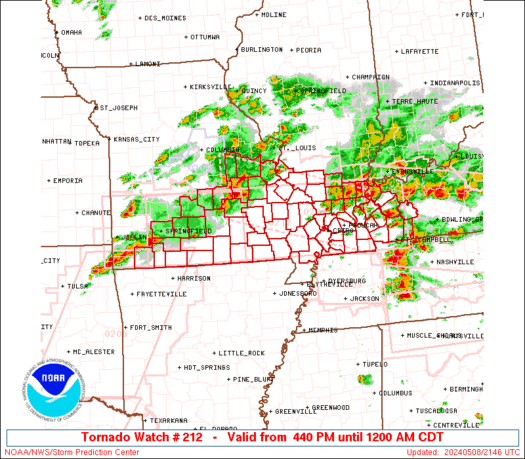
TORNADO WATCH NUMBER 212
NWS STORM PREDICTION CENTER NORMAN OK
900 PM CDT MON APR 21 2008

THE NWS STORM PREDICTION CENTER HAS ISSUED A
TORNADO WATCH FOR PORTIONS OF

CENTRAL AND SOUTHERN OKLAHOMA

EFFECTIVE THIS MONDAY NIGHT AND TUESDAY MORNING FROM 900 PM UNTIL
200 AM CDT.

TORNADOES...HAIL TO 2.5 INCHES IN DIAMETER...THUNDERSTORM WIND
GUSTS TO 70 MPH...AND DANGEROUS LIGHTNING ARE POSSIBLE IN THESE
AREAS.

THE TORNADO WATCH AREA IS APPROXIMATELY ALONG AND 45 STATUTE
MILES EAST AND WEST OF A LINE FROM 45 MILES NORTH OF CHANDLER
OKLAHOMA TO 10 MILES SOUTH OF ARDMORE OKLAHOMA. FOR A COMPLETE
DEPICTION OF THE WATCH SEE THE ASSOCIATED WATCH OUTLINE UPDATE
(WOUS64 KWNS WOU2).

REMEMBER...A TORNADO WATCH MEANS CONDITIONS ARE FAVORABLE FOR
TORNADOES AND SEVERE THUNDERSTORMS IN AND CLOSE TO THE WATCH
AREA. PERSONS IN THESE AREAS SHOULD BE ON THE LOOKOUT FOR
THREATENING WEATHER CONDITIONS AND LISTEN FOR LATER STATEMENTS
AND POSSIBLE WARNINGS.

OTHER WATCH INFORMATION...CONTINUE...WW 211...

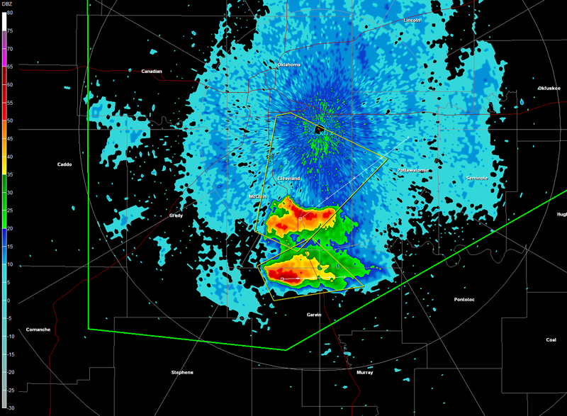
DISCUSSION...ISOLATED TSTM IN SW OK THAT FORMED EARLIER THIS EVENING
ALONG MERGING PREFRONTAL BOUNDARIES APPEARS TO HAVE BECOME A
SUSTAINED SUPERCELL. GIVEN INCREASINGLY MOIST LOW-LEVEL
ENVIRONMENT... POTENTIAL FOR A SLIGHT NOCTURNAL INCREASE IN THE SLY
LLJ...AND GRAZING INFLUENCE OF ERN CO/WRN KS UPR TROUGH...THREAT
WILL EXIST FOR A TORNADO OR TWO IN ADDITION TO VERY LARGE HAIL AND
LOCALLY DMGG WIND.

AVIATION...TORNADOES AND A FEW SEVERE THUNDERSTORMS WITH HAIL
SURFACE AND ALOFT TO 2.5 INCHES. EXTREME TURBULENCE AND SURFACE
WIND GUSTS TO 60 KNOTS. A FEW CUMULONIMBI WITH MAXIMUM TOPS TO
500. MEAN STORM MOTION VECTOR 26020.


...CORFIDI
0 likes   

RL3AO
Moderator-Pro Met
Moderator-Pro Met
Posts: 16308
Joined: Thu Jun 14, 2007 10:03 pm
Location: NC

#539 Postby RL3AO » Mon Apr 21, 2008 9:03 pm

I wouldn't rule out a TOR with the Garvin County cell in the next ten minutes.
0 likes   

User avatar
brunota2003
S2K Supporter
S2K Supporter
Posts: 9476
Age: 34
Joined: Sat Jul 30, 2005 9:56 pm
Location: Stanton, KY...formerly Havelock, NC
Contact:

#540 Postby brunota2003 » Mon Apr 21, 2008 11:10 pm

Apparently, the NWS in Newport just couldnt resist putting themselves into the Special Weather Statement they issued a few minutes ago :lol::

SPECIAL WEATHER STATEMENT
NATIONAL WEATHER SERVICE NEWPORT/MOREHEAD CITY NC
1200 AM EDT TUE APR 22 2008

NCZ095-220500-
CARTERET-
1200 AM EDT TUE APR 22 2008

...STRONG THUNDERSTORMS WILL AFFECT CARTERET COUNTY UNTIL 100 AM
EDT...

AT MIDNIGHT EDT...THERE WERE STRONG THUNDERSTORMS 14 MILES SOUTHEAST
OF BEAUFORT...MOVING NORTHWEST AT 15 MPH. THE STRONG THUNDERSTORMS
WILL BE NEAR CAPE LOOKOUT LIGHTHOUSE AT 1210 AM EDT...CAPE LOOKOUT AT
1215 AM EDT...HARKERS ISLAND AT 1225 AM EDT...BEAUFORT AT 1245 AM
EDT...FORT MACON STATE PARK AT 1250 AM EDT...ATLANTIC BEACH AT 1255
AM EDT. OTHER LOCATIONS TO BE AFFECTED BY THE STORMS INCLUDE
MOREHEAD CITY...AND POSSIBLY NEWPORT.

WIND GUSTS OF 30 TO 40 MPH AND PEA SIZE HAIL CAN BE EXPECTED WITH
THESE STORMS. HEAVY RAINFALL WILL CAUSE PONDING OF WATER ON ROADWAYS
AND LOCALIZED FLOODING IN LOW LYING AREAS. MOTORISTS SHOULD SLOW
DOWN ON AREA ROADWAYS TO AVOID HYDROPLANING.

STAY TUNED TO NOAA WEATHER RADIO OR OTHER LOCAL MEDIA OUTLETS FOR
FURTHER UPDATES ON THE WEATHER SITUATION ACROSS THE AREA.

$$
0 likes   


Return to “USA & Caribbean Weather”

Who is online

Users browsing this forum: Google Adsense [Bot], snownado and 8 guests