
There has been an ULL to the west of Beryl and another area of low pressure to the north that filled. The TUT over PR is starting to lift out at least temporarily.
Climo for this time of year suggests shear in the Caribbean would blow a weak system apart.
But if Beryl does strengthen a little more than expected in the low shear window it might build enough ridging to ward off the shear.
ATL: BERYL - Post-Tropical
Moderator: S2k Moderators
Re: ATL: BERYL - Hurricane
1 likes
Re: ATL: BERYL - Hurricane
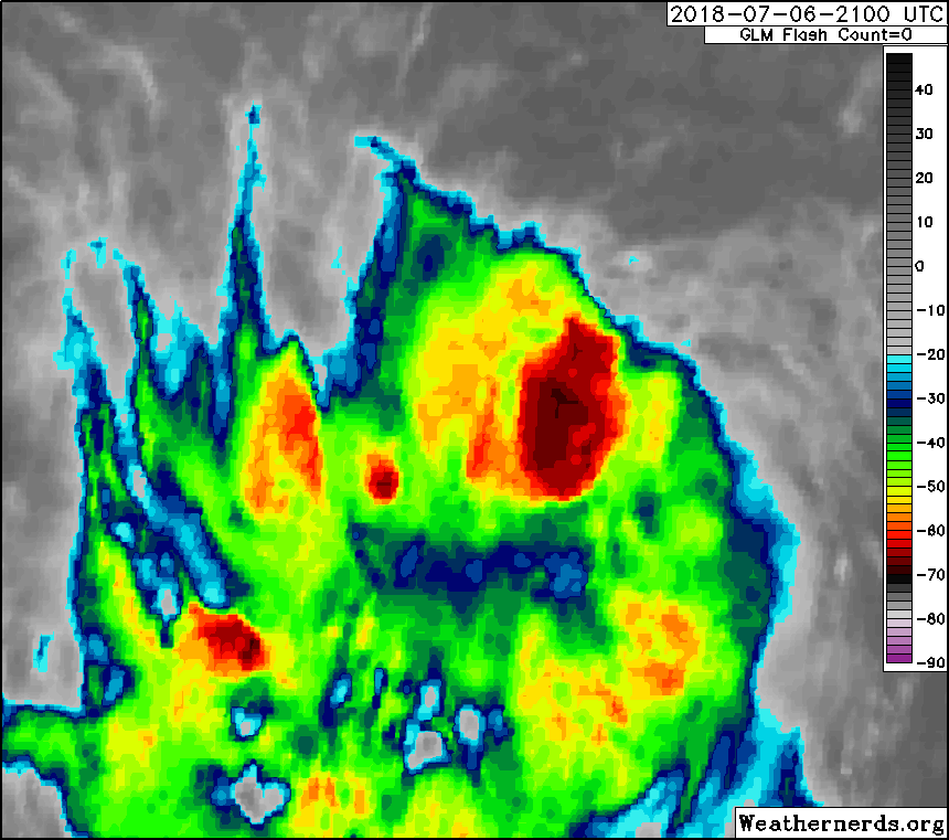
Looks more like a depression the past few hours - much less organized than 12 hours ago:
http://tropic.ssec.wisc.edu/real-time/s ... 000&loop=0
http://tropic.ssec.wisc.edu/real-time/s ... 000&loop=0
1 likes
-
cycloneye

- Admin

- Posts: 149377
- Age: 69
- Joined: Thu Oct 10, 2002 10:54 am
- Location: San Juan, Puerto Rico
Re: ATL: BERYL - Advisories
BULLETIN
Hurricane Beryl Intermediate Advisory Number 6A
NWS National Hurricane Center Miami FL AL022018
800 PM AST Fri Jul 06 2018
...BERYL CONTINUING WESTWARD ACROSS THE TROPICAL ATLANTIC...
SUMMARY OF 800 PM AST...0000 UTC...INFORMATION
----------------------------------------------
LOCATION...10.6N 48.3W
ABOUT 925 MI...1490 KM ESE OF THE LESSER ANTILLES
MAXIMUM SUSTAINED WINDS...80 MPH...130 KM/H
PRESENT MOVEMENT...W OR 270 DEGREES AT 15 MPH...24 KM/H
MINIMUM CENTRAL PRESSURE...994 MB...29.36 INCHES
WATCHES AND WARNINGS
--------------------
CHANGES WITH THIS ADVISORY:
None.
SUMMARY OF WATCHES AND WARNINGS IN EFFECT:
A Hurricane Watch is in effect for...
* Dominica
A Tropical Storm Watch is in effect for...
* Martinique
* Guadeloupe
* St. Martin
* St. Barthelemy
A Hurricane Watch means that hurricane conditions are possible
within the watch area.
A Tropical Storm Watch means that tropical storm conditions are
possible within the watch area.
Interests elsewhere in the Lesser Antilles should monitor the
progress of Beryl, as additional watches could be required for other
islands later tonight or early Saturday.
DISCUSSION AND OUTLOOK
----------------------
At 800 PM AST (0000 UTC), the center of Hurricane Beryl was located
near latitude 10.6 North, longitude 48.3 West. Beryl is moving
toward the west near 15 mph (24 km/h). A faster westward to
west-northwestward motion is expected to begin over the weekend and
continue through early next week. On the forecast track, the center
of Beryl will approach the Lesser Antilles over the weekend and
cross the island chain late Sunday or Monday.
Maximum sustained winds are near 80 mph (130 km/h) with higher
gusts. Some strengthening is forecast during the next couple of
days, and Beryl could still be a hurricane when it reaches the
Lesser Antilles late Sunday or Monday. Weakening is expected once
Beryl reaches the eastern Caribbean Sea on Monday, but the system
may not degenerate into an open trough until it reaches the vicinity
of Hispaniola and the central Caribbean Sea.
Hurricane-force winds extend outward up to 10 miles (20 km) from
the center, and tropical-storm-force winds extend outward up to
35 miles (55 km).
The estimated minimum central pressure is 994 mb (29.36 inches).
HAZARDS AFFECTING LAND
----------------------
WIND: Tropical storm or hurricane conditions are possible within
the watch areas by late Sunday or Monday.
NEXT ADVISORY
-------------
Next complete advisory at 1100 PM AST.
$$
Forecaster Beven
0 likes
Visit the Caribbean-Central America Weather Thread where you can find at first post web cams,radars
and observations from Caribbean basin members Click Here
and observations from Caribbean basin members Click Here
Re: ATL: BERYL - Hurricane
Same as last night very dry except near that vigorous core circulation.
0 likes
-
Aric Dunn
- Category 5

- Posts: 21238
- Age: 43
- Joined: Sun Sep 19, 2004 9:58 pm
- Location: Ready for the Chase.
- Contact:
Re: ATL: BERYL - Hurricane
that NE shear is doing some weird stuff the convective pattern
1 likes
Note: If I make a post that is brief. Please refer back to previous posts for the analysis or reasoning. I do not re-write/qoute what my initial post said each time.
If there is nothing before... then just ask
Space & Atmospheric Physicist, Embry-Riddle Aeronautical University,
I believe the sky is falling...
If there is nothing before... then just ask
Space & Atmospheric Physicist, Embry-Riddle Aeronautical University,
I believe the sky is falling...


Re: ATL: BERYL - Hurricane
Aric Dunn wrote:that NE shear is doing some weird stuff the convective pattern
Lol, it looks like the core convection is rotating clockwise.
2 likes
Re: ATL: BERYL - Hurricane
Siker wrote:Aric Dunn wrote:that NE shear is doing some weird stuff the convective pattern
Lol, it looks like the core convection is rotating clockwise.
That is an illusion like plane propellers rotating backwards because they are out of synch with the frame rate.
0 likes
-
404UserNotFound
- Tropical Depression

- Posts: 60
- Joined: Sun Dec 01, 2013 6:21 pm
- Location: Near Antipodes of Crozet Islands
Re: ATL: BERYL - Hurricane
Nimbus wrote:Siker wrote:Aric Dunn wrote:that NE shear is doing some weird stuff the convective pattern
Lol, it looks like the core convection is rotating clockwise.
That is an illusion like plane propellers rotating backwards because they are out of synch with the frame rate.
Not only can propellers appear to move backward, they can also appear to disconnect and reconnect.

0 likes
Please note: Never take any statements I make about forecasts at face value, as I am nowhere near professional at that.
-
gatorcane

- S2K Supporter

- Posts: 23708
- Age: 48
- Joined: Sun Mar 13, 2005 3:54 pm
- Location: Boca Raton, FL
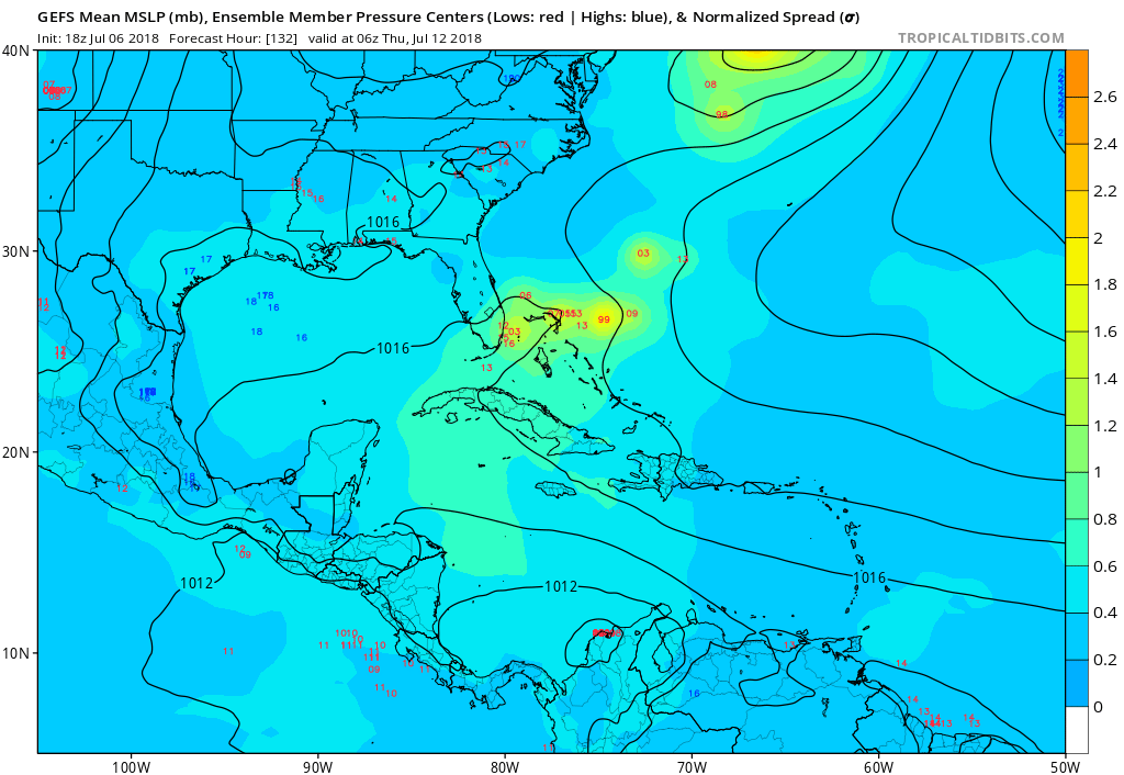
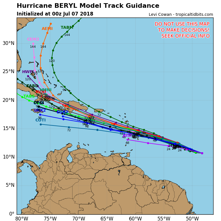
Re: ATL: BERYL - Models
18Z GFS with a number of ensembles keeping Beryl around as it recurves. Solutions range from Southern Florida to the Bahamas or east of:
0 likes
-
tolakram
- Admin
- Posts: 20185
- Age: 62
- Joined: Sun Aug 27, 2006 8:23 pm
- Location: Florence, KY (name is Mark)
Re: ATL: BERYL - Hurricane
0 likes
M a r k
- - - - -
Join us in chat: Storm2K Chatroom Invite. Android and IOS apps also available.
The posts in this forum are NOT official forecasts and should not be used as such. Posts are NOT endorsed by any professional institution or STORM2K.org. For official information and forecasts, please refer to NHC and NWS products.
-
cycloneye
- Admin
- Posts: 149377
- Age: 69
- Joined: Thu Oct 10, 2002 10:54 am
- Location: San Juan, Puerto Rico
Re: ATL: BERYL - Hurricane
TXNT26 KNES 070007
TCSNTL
A. 02L (BERYL)
B. 06/2345Z
C. 10.7N
D. 48.2W
E. THREE/GOES-E
F. T4.0/4.0/D0.5/24HRS
G. IR/EIR/SWIR
H. REMARKS...CENTER IS BELIEVED TO BE EMBEDDED IN OW RESULTING IN A DT
OF 3.5. MET IS 4.0 BASED ON 24 HOUR SLOW DEVELOPMENT TREND. PT IS ALSO
4.0. FT IS BASED ON MET DUE TO UNCERTAINTY IN THE PRECISE CENTER LOCATION.
I. ADDL POSITIONS
NIL
...TURK
2 likes
Visit the Caribbean-Central America Weather Thread where you can find at first post web cams,radars
and observations from Caribbean basin members Click Here
and observations from Caribbean basin members Click Here
-
cycloneye
- Admin
- Posts: 149377
- Age: 69
- Joined: Thu Oct 10, 2002 10:54 am
- Location: San Juan, Puerto Rico
Re: ATL: BERYL - Hurricane
00z Best Track:
Location: 10.7°N 48.3°W
Maximum Winds: 70 kt Gusts: N/A
Minimum Central Pressure: 994 mb
Environmental Pressure: 1013 mb
Radius of Circulation: 120 NM
Radius of Maximum Wind: 5 NM
Eye Diameter: 5 NM
Maximum Winds: 70 kt Gusts: N/A
Minimum Central Pressure: 994 mb
Environmental Pressure: 1013 mb
Radius of Circulation: 120 NM
Radius of Maximum Wind: 5 NM
Eye Diameter: 5 NM
1 likes
Visit the Caribbean-Central America Weather Thread where you can find at first post web cams,radars
and observations from Caribbean basin members Click Here
and observations from Caribbean basin members Click Here
-
TheStormExpert
Re: ATL: BERYL - Models
1 likes
-
cycloneye
- Admin
- Posts: 149377
- Age: 69
- Joined: Thu Oct 10, 2002 10:54 am
- Location: San Juan, Puerto Rico
Re: ATL: BERYL - Models
Code: Select all
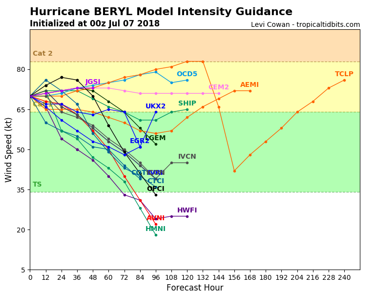
                    * ATLANTIC     2018 SHIPS INTENSITY FORECAST     *
                    * IR SAT DATA AVAILABLE,       OHC AVAILABLE     *
                    *  BERYL       AL022018  07/07/18  00 UTC        *

TIME (HR)          0     6    12    18    24    36    48    60    72    84    96   108   120
V (KT) NO LAND    70    71    72    72    72    72    69    66    64    61    61    64    65
V (KT) LAND       70    71    72    72    72    72    69    66    64    61    61    64    65
V (KT) LGEM       70    71    71    71    72    73    72    68    64    58    52   DIS   DIS
Storm Type      TROP  TROP  TROP  TROP  TROP  TROP  TROP  TROP  TROP  TROP  TROP   N/A   N/A

SHEAR (KT)         1     4     9     9     6    17    17    28    34    41    38   N/A   N/A
SHEAR ADJ (KT)     0     0     2     2     6     4     2     0    -1    -4    -3   N/A   N/A
SHEAR DIR        312   316   321   328   290   300   270   278   277   281   261   N/A   N/A
SST (C)         27.2  27.1  27.2  26.8  26.6  27.4  27.6  27.9  27.8  28.9  29.5   N/A   N/A
POT. INT. (KT)   127   126   127   123   122   132   135   139   138   154   163   N/A   N/A
ADJ. POT. INT.   127   125   127   123   122   135   140   146   143   157   166   N/A   N/A
200 MB T (C)   -54.7 -54.6 -54.5 -54.3 -54.3 -54.8 -54.5 -55.2 -54.3 -54.6 -54.2   N/A   N/A
200 MB VXT (C)  -0.2  -0.2  -0.1  -0.1   0.1   0.1   0.0  -0.2   0.0   0.2   0.1  N/A   N/A
TH_E DEV (C)       6     6     6     6     7     8     9     9    11    11    12   N/A   N/A
700-500 MB RH     58    59    60    58    59    54    53    52    53    54    56   N/A   N/A
MODEL VTX (KT)    14    13    15    13    12    13    10     9     8     6     5  LOST  LOST
850 MB ENV VOR    46    47    44    51    52    43    45    50    56    39     5   N/A   N/A
200 MB DIV        16    19    20    20    20    17    33    47    47    35    55   N/A   N/A
700-850 TADV      -5    -3    -2    -1     0     4     3    12     0    14    11   N/A   N/A
LAND (KM)        789   749   727   720   740   576   379   340   168    30    65   N/A   N/A
LAT (DEG N)     10.7  11.0  11.3  11.8  12.3  13.2  14.1  15.3  16.6  17.9  18.9   N/A   N/A
LONG(DEG W)     48.3  49.4  50.5  51.8  53.1  56.3  60.1  64.4  68.9  73.1  76.9   N/A   N/A
STM SPEED (KT)    11    11    12    14    15    18    20    22    22    20    19   N/A   N/A
HEAT CONTENT       6     7    12    11     3     9    13    27    24    36    44  9999  9999

  FORECAST TRACK FROM OFCI      INITIAL HEADING/SPEED (DEG/KT):270/ 12      CX,CY: -11/  0
  T-12 MAX WIND:  70            PRESSURE OF STEERING LEVEL (MB):  560  (MEAN=619)
  GOES IR BRIGHTNESS TEMP. STD DEV.  50-200 KM RAD:  17.8 (MEAN=14.5)
  % GOES IR PIXELS WITH T < -20 C    50-200 KM RAD:  35.0 (MEAN=65.0)
  PRELIM RI PROB (DV .GE. 55 KT IN 48 HR):            0.8

                        INDIVIDUAL CONTRIBUTIONS TO INTENSITY CHANGE
                         6   12   18   24   36   48   60   72   84   96  108  120
                        ----------------------------------------------------------
  SAMPLE MEAN CHANGE     1.   2.   3.   4.   6.   8.   9.  10.  11.  12.  12.  13.
  SST POTENTIAL          1.   2.   3.   3.   4.   4.   3.   3.   4.   5.   5.   5.
  VERTICAL SHEAR MAG     1.   1.   1.   2.   1.   1.  -1.  -3.  -7.  -8.  -7.  -5.
  VERTICAL SHEAR ADJ     0.   0.   0.   0.  -1.  -1.  -1.  -1.   0.   0.   0.   0.
  VERTICAL SHEAR DIR     0.   0.   0.   0.  -1.  -2.  -3.  -4.  -5.  -6.  -7.  -8.
  PERSISTENCE            0.  -1.  -1.  -1.   0.   0.   0.   0.   0.   0.   0.   0.
  200/250 MB TEMP.       0.   0.   0.   0.   0.   1.   1.   1.   1.   1.   2.   2.
  THETA_E EXCESS         0.   0.  -1.  -1.  -1.  -1.  -1.   0.   0.   0.   0.   0.
  700-500 MB RH          0.   0.   0.   0.   0.  -1.  -1.  -1.  -1.  -1.  -1.  -1.
  MODEL VTX TENDENCY     0.   0.  -1.  -2.  -2.  -5.  -8. -10. -14. -16. -17. -17.
  850 MB ENV VORTICITY   0.   0.   0.   0.   0.   1.   1.   1.   1.   1.   1.   1.
  200 MB DIVERGENCE      0.   0.   0.   0.  -1.  -1.   0.   0.   0.   0.   0.   0.
  850-700 T ADVEC        0.   0.   0.   0.   0.   0.   0.   0.   0.   0.   0.   0.
  ZONAL STORM MOTION     0.   0.   0.   0.   0.   1.   1.   1.   1.   1.   2.   2.
  STEERING LEVEL PRES    0.   0.   0.   0.   0.   0.   0.   0.   0.   0.   1.   1.
  DAYS FROM CLIM. PEAK   0.   0.   0.   0.   0.   0.   0.   1.   1.   1.   1.   1.
  GOES PREDICTORS       -1.  -2.  -2.  -3.  -3.  -3.  -2.  -2.  -1.   0.   1.   0.
  OCEAN HEAT CONTENT     0.   0.   0.   0.   0.   0.   0.   0.   0.   0.   0.   0.
  RI POTENTIAL           0.   0.   0.  -1.  -2.  -2.  -2.  -2.  -1.  -1.   0.   0.
                        ----------------------------------------------------------
  TOTAL CHANGE           1.   2.   2.   2.   2.  -1.  -4.  -6.  -9.  -9.  -6.  -5.

                CURRENT MAX WIND (KT):   70. LAT, LON:   10.7    48.3

      ** 2018 ATLANTIC RI INDEX AL022018 BERYL      07/07/18  00 UTC **
 (SHIPS-RII PREDICTOR TABLE for 30 KT OR MORE MAXIMUM WIND INCREASE IN NEXT 24-h)

     Predictor                  Value   RI Predictor Range  Scaled Value(0-1) % Contribution
 12 HR PERSISTENCE (KT)      :    0.0    -49.5  to   38.5        0.56           5.2
 850-200 MB SHEAR (KT)       :    5.9     30.1  to    2.3        0.87           3.6
 HEAT CONTENT (KJ/CM2)       :    7.8      0.0  to  157.3        0.05           0.2
 STD DEV OF IR BR TEMP       :   17.8     36.6  to    2.8        0.56           2.0
 2nd PC OF IR BR TEMP        :   -0.3      2.9  to   -2.9        0.56           1.9
 MAXIMUM WIND (KT)           :   70.0     22.5  to  132.0        0.86           1.6
 BL DRY-AIR FLUX (W/M2)      :  314.2    893.2  to  -67.1        0.60           1.5
 POT = MPI-VMAX (KT)         :   54.7     28.4  to  141.4        0.23           0.2
 D200 (10**7s-1)             :   19.0    -29.7  to  185.9        0.23           0.1
 %area of TPW <45 mm upshear :   63.2    100.0  to    0.0        0.37           0.1

 SHIPS Prob RI for 20kt/ 12hr RI threshold=   7% is   1.4 times climatological mean ( 5.0%)
 SHIPS Prob RI for 25kt/ 24hr RI threshold=  19% is   1.8 times climatological mean (10.9%)
 SHIPS Prob RI for 30kt/ 24hr RI threshold=  16% is   2.5 times climatological mean ( 6.7%)
 SHIPS Prob RI for 35kt/ 24hr RI threshold=   0% is   0.0 times climatological mean ( 3.8%)
 SHIPS Prob RI for 40kt/ 24hr RI threshold=   0% is   0.0 times climatological mean ( 2.4%)
 SHIPS Prob RI for 45kt/ 36hr RI threshold=  14% is   3.0 times climatological mean ( 4.5%)
 SHIPS Prob RI for 55kt/ 48hr RI threshold=  12% is   2.7 times climatological mean ( 4.6%)
 SHIPS Prob RI for 65kt/ 72hr RI threshold=   9% is   1.6 times climatological mean ( 5.4%)

Matrix of RI probabilities
------------------------------------------------------------------------------
  RI (kt / h)  | 20/12 | 25/24 | 30/24 | 35/24 | 40/24 | 45/36 | 55/48  |65/72
------------------------------------------------------------------------------
   SHIPS-RII:     7.0%   19.2%   16.4%    0.0%    0.0%   13.7%   12.3%    8.6%
    Logistic:     3.3%    9.7%    8.0%    4.0%    1.5%    2.4%    0.8%    0.5%
    Bayesian:     0.5%    0.4%    0.6%    0.0%    0.0%    0.1%    0.0%    0.0%
   Consensus:     3.6%    9.7%    8.3%    1.3%    0.5%    5.4%    4.4%    3.1%
       DTOPS:    17.0%    1.0%    1.0%    0.0%    0.0%    0.0%    0.0%    0.0%

   ##         ANNULAR HURRICANE INDEX (AHI) AL022018 BERYL      07/07/18  00 UTC         ##
   ## STORM NOT ANNULAR, SCREENING STEP FAILED, NPASS=4 NFAIL=3                          ##
   ## AHI=  0   (AHI OF 100 IS BEST FIT TO ANN. STRUC., 1 IS MARGINAL, 0 IS NOT ANNULAR) ##

                          CONTRIBUTIONS TO ANNULAR INDEX


** PROBLTY OF AT LEAST 1 SCNDRY EYEWL FORMTN EVENT AL022018 BERYL      07/07/2018  00 UTC **
TIME(HR)   0-12  12-24(0-24)  24-36(0-36)  36-48(0-48)
CLIMO(%)   ***    ***(***)     ***(***)     ***(***)     <-- PROB BASED ON INTENSITY ONLY
PROB(%)     ER     ERR          ERR          ERR         <-- FULL MODEL PROB (RAN NORMALLY)

** DSHIPS INTENSITY FORECAST ADJUSTED RELATIVE TO ONSET OF ERC WEAKENING PHASE **
      TIME (HR)      0     6    12    18    24    36    48    60    72    84    96   108   120
>24HR AGO (DSHIPS)  70    71    72    72    72    72    69    66    64    61    61    64    65
 18HR AGO           70    69    70    70    70    70    67    64    62    59    59    62    63
 12HR AGO           70    67    66    66    66    66    63    60    58    55    55    58    59
  6HR AGO           70    64    61    60    60    60    57    54    52    49    49    52    53
      NOW                              CURRENT INTENSITY < 83 KT
  IN  6HR                              INTENSITY IN  6HR < 83 KT
  IN 12HR                              INTENSITY IN 12HR < 83 KT
0 likes
Visit the Caribbean-Central America Weather Thread where you can find at first post web cams,radars
and observations from Caribbean basin members Click Here
and observations from Caribbean basin members Click Here
-
wxman57

- Moderator-Pro Met

- Posts: 23172
- Age: 68
- Joined: Sat Jun 21, 2003 8:06 pm
- Location: Houston, TX (southwest)
Re: ATL: BERYL - Hurricane
Got a recent microwave hit. No evidence of an eye at all. Limited convection. Doubt it's still a hurricane. Small storms can strengthen AND weaken very quickly.
1 likes

Re: ATL: BERYL - Hurricane
wxman57 wrote:Got a recent microwave hit. No evidence of an eye at all. Limited convection. Doubt it's still a hurricane. Small storms can strengthen AND weaken very quickly.
What are your thoughts on future intensity? NHC keeps it a hurricane through the islands but I'm thinking this is the start of a longer term weakening trend as it's approaching the edge of the moisture envelope.
0 likes
The above post is not official and should not be used as such. It is the opinion of the poster and may or may not be backed by sound meteorological data. It is not endorsed by any professional institution or storm2k.org. For official information, please refer to the NHC and NWS products.
-
floridasun78
- Category 5
- Posts: 3755
- Joined: Sun May 17, 2009 10:16 pm
- Location: miami fl
Re: ATL: BERYL - Models
why models having issue with shear was suppose strong by sat? because 96l ? now td 36
1 likes
-
Aric Dunn
- Category 5
- Posts: 21238
- Age: 43
- Joined: Sun Sep 19, 2004 9:58 pm
- Location: Ready for the Chase.
- Contact:
Re: ATL: BERYL - Hurricane
Still easterly shear.. nothing will happen unless that stops of course.
0 likes
Note: If I make a post that is brief. Please refer back to previous posts for the analysis or reasoning. I do not re-write/qoute what my initial post said each time.
If there is nothing before... then just ask
Space & Atmospheric Physicist, Embry-Riddle Aeronautical University,
I believe the sky is falling...
If there is nothing before... then just ask
Space & Atmospheric Physicist, Embry-Riddle Aeronautical University,
I believe the sky is falling...

Re: ATL: BERYL - Hurricane
Don't see any significant shear on the latest CIMSS...maybe 10kts, not sure.
That is as of 0000Z
That is as of 0000Z
1 likes
Who is online
Users browsing this forum: No registered users and 25 guests