ATL: NICHOLAS - Post-Tropical - Discussion

Moderator: S2k Moderators

Message
Author
paintplaye
Category 1
Category 1
Posts: 380
Joined: Sun Jul 20, 2008 11:25 pm

Re: ATL: NICHOLAS - Tropical Storm - Discussion

#521 Postby paintplaye » Mon Sep 13, 2021 4:48 am

kevin wrote:Looks like the most recent eye feature we just discussed is degrading again a bit, but I can't really tell if that means that another feature will become dominant again. Maybe it's just part of the pulse up / pulse down cycle of Nicholas. Guess all we can do for now is wait and see.


Radar still shows center intact SE of Brownsville. A lot of the eye-like feature you might be looking is due to the convergence of boundaries. Nicholas is still experiencing southwesterly shear which is one of the reasons a lot of the convection remains east. If additional convection does not pop up further west we may see a lot of these storms weaken some later this morning.
0 likes   

grapealcoholic
Category 2
Category 2
Posts: 684
Joined: Tue Aug 10, 2021 3:26 pm

Re: ATL: NICHOLAS - Tropical Storm - Discussion

#522 Postby grapealcoholic » Mon Sep 13, 2021 4:58 am

paintplaye wrote:
kevin wrote:Looks like the most recent eye feature we just discussed is degrading again a bit, but I can't really tell if that means that another feature will become dominant again. Maybe it's just part of the pulse up / pulse down cycle of Nicholas. Guess all we can do for now is wait and see.


Radar still shows center intact SE of Brownsville. A lot of the eye-like feature you might be looking is due to the convergence of boundaries. Nicholas is still experiencing southwesterly shear which is one of the reasons a lot of the convection remains east. If additional convection does not pop up further west we may see a lot of these storms weaken some later this morning.

The feature SE of brownsville is remnant mid level spin and isn't at the surface. There's more broad spin near 95W
0 likes   

catskillfire51
S2K Supporter
S2K Supporter
Posts: 480
Age: 38
Joined: Sun Aug 26, 2012 5:40 pm
Location: Lake Jackson, TX

Re: ATL: NICHOLAS - Tropical Storm - Discussion

#523 Postby catskillfire51 » Mon Sep 13, 2021 5:07 am

If yall look at the current GFS run it actually is showing this perfectly, in regards to the two separate areas.
0 likes   

paintplaye
Category 1
Category 1
Posts: 380
Joined: Sun Jul 20, 2008 11:25 pm

Re: ATL: NICHOLAS - Tropical Storm - Discussion

#524 Postby paintplaye » Mon Sep 13, 2021 5:17 am

grapealcoholic wrote:
paintplaye wrote:
kevin wrote:Looks like the most recent eye feature we just discussed is degrading again a bit, but I can't really tell if that means that another feature will become dominant again. Maybe it's just part of the pulse up / pulse down cycle of Nicholas. Guess all we can do for now is wait and see.


Radar still shows center intact SE of Brownsville. A lot of the eye-like feature you might be looking is due to the convergence of boundaries. Nicholas is still experiencing southwesterly shear which is one of the reasons a lot of the convection remains east. If additional convection does not pop up further west we may see a lot of these storms weaken some later this morning.

The feature SE of brownsville is remnant mid level spin and isn't at the surface. There's more broad spin near 95W


That is the current LLC. Radar is only 3k feet up at that point and continues to remain the location the NHC is tracking.
0 likes   

xironman
S2K Supporter
S2K Supporter
Posts: 2522
Joined: Sun Jun 10, 2007 4:53 pm
Location: NoVA

Re: ATL: NICHOLAS - Tropical Storm - Discussion

#525 Postby xironman » Mon Sep 13, 2021 5:28 am

The old feature near Brownsville seems to be fading and stalled.

Image
1 likes   

MBryant
Category 1
Category 1
Posts: 416
Joined: Fri Aug 27, 2004 7:13 pm
Location: Orange, Texas

Re: ATL: NICHOLAS - Tropical Storm - Discussion

#526 Postby MBryant » Mon Sep 13, 2021 5:29 am

My first encounter following a two eyed storm was in the early 70s. It delayed the development of the storm until it was onshore. This may be following suit. Of course back then all we had were reconnaissance flight report summaries.
1 likes   
Living at the intersection of Rita and Humberto and Ike and Harvey and Laura and Delta!

This post is NOT an official forecast and should not be used as such. It is just my opinion and may or may not be backed by sound meteorological products.

jaguars_22
Category 2
Category 2
Posts: 590
Joined: Tue Jun 20, 2017 2:26 pm
Location: Victoria TX

Re: ATL: NICHOLAS - Tropical Storm - Discussion

#527 Postby jaguars_22 » Mon Sep 13, 2021 5:54 am

It looks like the center may make landfall in south Texas??? Maybe the euro wasn’t horribly wrong
0 likes   

LSU Saint
Tropical Low
Tropical Low
Posts: 44
Joined: Wed Jul 22, 2020 5:44 pm

Re: ATL: NICHOLAS - Tropical Storm - Discussion

#528 Postby LSU Saint » Mon Sep 13, 2021 6:16 am

jaguars_22 wrote:It looks like the center may make landfall in south Texas??? Maybe the euro wasn’t horribly wrong


Is this better or worse for Houston?
0 likes   

jaguars_22
Category 2
Category 2
Posts: 590
Joined: Tue Jun 20, 2017 2:26 pm
Location: Victoria TX

Re: ATL: NICHOLAS - Tropical Storm - Discussion

#529 Postby jaguars_22 » Mon Sep 13, 2021 6:19 am

Idk what’s going on with this storm! Looks like the center moved south a bit?? Nicholas is weird
0 likes   

User avatar
GCANE
S2K Supporter
S2K Supporter
Posts: 11496
Joined: Mon Oct 22, 2007 8:03 am

Re: ATL: NICHOLAS - Tropical Storm - Discussion

#530 Postby GCANE » Mon Sep 13, 2021 6:20 am

2 likes   

tolakram
Admin
Admin
Posts: 20009
Age: 62
Joined: Sun Aug 27, 2006 8:23 pm
Location: Florence, KY (name is Mark)

Re: ATL: NICHOLAS - Tropical Storm - Discussion

#531 Postby tolakram » Mon Sep 13, 2021 6:22 am

Holy crap, just catching up with reality this morning.

saved loop
Image
0 likes   
M a r k
- - - - -
Join us in chat: Storm2K Chatroom Invite. Android and IOS apps also available.

The posts in this forum are NOT official forecasts and should not be used as such. Posts are NOT endorsed by any professional institution or STORM2K.org. For official information and forecasts, please refer to NHC and NWS products.

User avatar
wxman57
Moderator-Pro Met
Moderator-Pro Met
Posts: 22978
Age: 67
Joined: Sat Jun 21, 2003 8:06 pm
Location: Houston, TX (southwest)

Re: ATL: NICHOLAS - Tropical Storm - Discussion

#532 Postby wxman57 » Mon Sep 13, 2021 6:26 am

Perhaps a small counter-clockwise loop? Seems on-track this morning. Local Houston paper says heavy rain here Tue-Wed. More like this evening to 9am Tuesday then off to the east. Even though the center may move slowly northeast once it passes to our north (Houston), the squalls will be WELL to the east of the exposed center.
2 likes   

tolakram
Admin
Admin
Posts: 20009
Age: 62
Joined: Sun Aug 27, 2006 8:23 pm
Location: Florence, KY (name is Mark)

Re: ATL: NICHOLAS - Tropical Storm - Discussion

#533 Postby tolakram » Mon Sep 13, 2021 6:26 am

saved loop
Image
5 likes   
M a r k
- - - - -
Join us in chat: Storm2K Chatroom Invite. Android and IOS apps also available.

The posts in this forum are NOT official forecasts and should not be used as such. Posts are NOT endorsed by any professional institution or STORM2K.org. For official information and forecasts, please refer to NHC and NWS products.

tolakram
Admin
Admin
Posts: 20009
Age: 62
Joined: Sun Aug 27, 2006 8:23 pm
Location: Florence, KY (name is Mark)

Re: ATL: NICHOLAS - Tropical Storm - Discussion

#534 Postby tolakram » Mon Sep 13, 2021 6:29 am

000
WTNT44 KNHC 130850
TCDAT4

Tropical Storm Nicholas Discussion Number 5
NWS National Hurricane Center Miami FL AL142021
400 AM CDT Mon Sep 13 2021

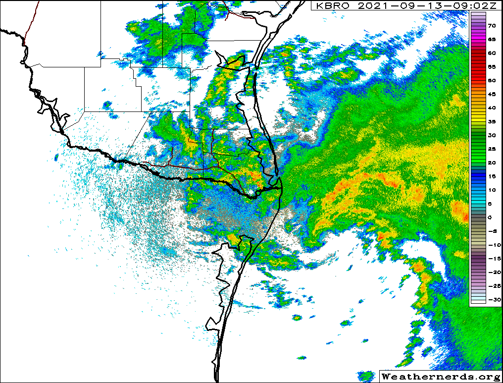
Radar data from Brownsville shows that the center of Nicholas is on
the southwestern side of a large area of deep convection over the
western Gulf of Mexico. While southwesterly shear continues to
affect the storm, the radar presentation has recently improved,
with what could be the start of a partial eyewall forming in the
northern quadrant. The initial wind speed remains 50 kt based on
earlier aircraft flight-level winds of 59 kt, believable SFMR
values up to 50 kt, along with radar winds at 5000 ft near 60 kt.

The storm is moving north-northwestward at about 12 kt. Nicholas is
forecast to turn northward soon into a weakness in the subtropical
ridge. The track prediction is only nudged slightly westward from
the previous one through landfall, consistent with recent model
guidance. Thereafter, there isn't good agreement among the models
on how quickly the tropical cyclone will move northeastward out of
Texas. Generally the models are faster this cycle, which seems
believable given the large northward re-formation earlier likely
exposing Nicholas to stronger mid-latitude flow. Thus the new NHC
forecast is trended faster as well, but remains behind the model
consensus. Obviously the forward speed is important to the heavy
rainfall forecast, and this trend will be one to watch.

Nicholas should continue to strengthen up until landfall due
primarily to the very warm Gulf waters and the recent inner-core
improvements. Moderate southwesterly shear and some dry air are the
main inhibiting factors and will hopefully keep the strengthening in
check. However, it is possible that Nicholas could become a
hurricane before landfall, and that's the reason for the hurricane
watch area. Nicholas should weaken after landfall, diminish into a
tropical depression within a couple of days, and degenerate into a
remnant low in about 3 days. No significant changes were made to
the previous NHC wind speed prediction.


Key Messages:

1. Heavy rainfall will impact portions of the Texas and Louisiana
coasts through the middle of the week. Significant rainfall amounts
are possible, potentially resulting in areas of considerable flash
and urban flooding, especially in highly urbanized metropolitan
areas. Isolated minor to moderate river flooding is also expected.

2. There is the danger of life-threatening storm surge inundation
along the coast of Texas from Port Aransas to San Luis Pass.
Residents in these areas should follow any advice given by
local officials.

3. Nicholas is forecast to approach the middle Texas coast as a
strong tropical storm today, and could be near hurricane
intensity at landfall. Tropical storm conditions are expected
along portions of the middle Texas coast beginning by this
afternoon, with hurricane conditions possible from Port Aransas to
Freeport this afternoon and tonight.

4. Tropical storm conditions are expected along portions of the
northeastern coast of Mexico and the coast of south Texas beginning
during the next few hours.


FORECAST POSITIONS AND MAX WINDS

INIT 13/0900Z 25.5N 96.6W 50 KT 60 MPH
12H 13/1800Z 27.3N 96.8W 60 KT 70 MPH
24H 14/0600Z 29.2N 96.5W 45 KT 50 MPH...INLAND
36H 14/1800Z 30.6N 95.8W 35 KT 40 MPH...INLAND
48H 15/0600Z 31.5N 94.5W 30 KT 35 MPH...INLAND
60H 15/1800Z 32.1N 93.0W 25 KT 30 MPH...INLAND
72H 16/0600Z 32.5N 91.5W 20 KT 25 MPH...POST-TROP/REMNT LOW
96H 17/0600Z...DISSIPATED

$$
Forecaster Blake
0 likes   
M a r k
- - - - -
Join us in chat: Storm2K Chatroom Invite. Android and IOS apps also available.

The posts in this forum are NOT official forecasts and should not be used as such. Posts are NOT endorsed by any professional institution or STORM2K.org. For official information and forecasts, please refer to NHC and NWS products.

User avatar
tropicwatch
Category 5
Category 5
Posts: 3383
Age: 61
Joined: Sat Jun 02, 2007 10:01 am
Location: Panama City Florida
Contact:

Re: ATL: NICHOLAS - Tropical Storm - Discussion

#535 Postby tropicwatch » Mon Sep 13, 2021 6:37 am

The Lighthouse at Brazos Santiago, TX was reporting a pressure of 1006mb just before 6am central time this morning. Winds were 32kts gusting to 38.
0 likes   
Tropicwatch


Agnes 72', Eloise 75, Elena 85', Kate 85', Charley 86', Florence 88', Beryl 94', Dean 95', Erin 95', Opal 95', Earl 98', Georges 98', Ivan 2004', Arlene 2005', Dennis 2005', Ida 2009' Debby 2012' Irma 2017' Michael 2018'

User avatar
NDG
S2K Supporter
S2K Supporter
Posts: 15446
Joined: Sun Jul 09, 2006 10:14 pm
Location: Orlando, FL

Re: ATL: NICHOLAS - Tropical Storm - Discussion

#536 Postby NDG » Mon Sep 13, 2021 6:45 am

Saved 7 hr radar loop, it looks to put on the breaks during the last hour or so and about to start taking the more northerly heading as forecasted.

1 likes   

MBryant
Category 1
Category 1
Posts: 416
Joined: Fri Aug 27, 2004 7:13 pm
Location: Orange, Texas

Re: ATL: NICHOLAS - Tropical Storm - Discussion

#537 Postby MBryant » Mon Sep 13, 2021 6:49 am

I'm having a difficult time with orientation between graphics. One looks like a center of circulation almost on top of Brownsville and the other is much further away and mostly eastward. Much of this is due to time and scale differences. Some is due to what appear to be multiple vortices, none of which have become dominant.

My best guess is the COC on radar is in the extreme NW of the broader area of CCW flow.

But like I said initially, I could be confused.
2 likes   
Living at the intersection of Rita and Humberto and Ike and Harvey and Laura and Delta!

This post is NOT an official forecast and should not be used as such. It is just my opinion and may or may not be backed by sound meteorological products.

tolakram
Admin
Admin
Posts: 20009
Age: 62
Joined: Sun Aug 27, 2006 8:23 pm
Location: Florence, KY (name is Mark)

Re: ATL: NICHOLAS - Tropical Storm - Discussion

#538 Postby tolakram » Mon Sep 13, 2021 6:52 am

MBryant wrote:I'm having a difficult time with orientation between graphics. One looks like a center of circulation almost on top of Brownsville and the other is much further away and mostly eastward. Much of this is due to time and scale differences. Some is due to what appear to be multiple vortices, none of which have become dominant.

My bet guess is the COC on radar is in the extreme NW of the broader area of CCW flow.

But like I said initially, I could be confused.


As 57 said, the center we see on radar is doing a counter clockwise loop around a broader circulation. Because movement has slowed it looks confusing, but it appears the center is now moving east / ne or reforming further northeast. The further it gets away from the radar site the higher the altitude, which adds to the mess.
1 likes   
M a r k
- - - - -
Join us in chat: Storm2K Chatroom Invite. Android and IOS apps also available.

The posts in this forum are NOT official forecasts and should not be used as such. Posts are NOT endorsed by any professional institution or STORM2K.org. For official information and forecasts, please refer to NHC and NWS products.

User avatar
aspen
Category 5
Category 5
Posts: 8818
Joined: Sat Oct 12, 2019 7:10 pm
Location: Connecticut, USA

Re: ATL: NICHOLAS - Tropical Storm - Discussion

#539 Postby aspen » Mon Sep 13, 2021 6:52 am

If the 06z HWRF is right, the center will be reforming much further east right now, but then jump back over a little west in the early afternoon. Radar suggests that hasn’t happened yet.
0 likes   
Irene '11 Sandy '12 Hermine '16 5/15/2018 Derecho Fay '20 Isaias '20 Elsa '21 Henri '21 Ida '21

I am only a meteorology enthusiast who knows a decent amount about tropical cyclones. Look to the professional mets, the NHC, or your local weather office for the best information.

User avatar
tropicwatch
Category 5
Category 5
Posts: 3383
Age: 61
Joined: Sat Jun 02, 2007 10:01 am
Location: Panama City Florida
Contact:

Re: ATL: NICHOLAS - Tropical Storm - Discussion

#540 Postby tropicwatch » Mon Sep 13, 2021 6:55 am

aspen wrote:If the 06z HWRF is right, the center will be reforming much further east right now, but then jump back over a little west in the early afternoon. Radar suggests that hasn’t happened yet.


Looking like the relocating east might be happening now.
0 likes   
Tropicwatch


Agnes 72', Eloise 75, Elena 85', Kate 85', Charley 86', Florence 88', Beryl 94', Dean 95', Erin 95', Opal 95', Earl 98', Georges 98', Ivan 2004', Arlene 2005', Dennis 2005', Ida 2009' Debby 2012' Irma 2017' Michael 2018'


Return to “2021”

Who is online

Users browsing this forum: No registered users and 8 guests