ATL: LEE - Models

Moderator: S2k Moderators

Message
Author
User avatar
Teban54
Category 5
Category 5
Posts: 3168
Joined: Sat May 19, 2018 1:19 pm

Re: RE: Re: ATL: LEE - Models

#521 Postby Teban54 » Wed Sep 06, 2023 6:33 pm

jlauderdal wrote:
TheDreamTraveler wrote:Pretty huge shift there lol

https://twitter.com/webberweather/status/1699562532397363291
There is a reason its called the gfs happy hour, give it a cycle or two and reality will return.

The tweet shows 8 runs, only 2 of which are 18z runs. Even if you take them out, the general trend is still SW.
4 likes   

User avatar
cheezyWXguy
Category 5
Category 5
Posts: 6092
Joined: Mon Feb 13, 2006 12:29 am
Location: Dallas, TX

Re: RE: Re: ATL: LEE - Models

#522 Postby cheezyWXguy » Wed Sep 06, 2023 6:38 pm

jlauderdal wrote:
TheDreamTraveler wrote:Pretty huge shift there lol

https://twitter.com/webberweather/status/1699562532397363291
There is a reason its called the gfs happy hour, give it a cycle or two and reality will return.

The reason that term came about was because years ago the 18z used to get fed the least amount of new data of all four runs in a given day, resulting in reduced accuracy relative to the other runs. However, this hasn’t really been a thing in the last 10 years or so
8 likes   

MEANINGLESS_NUMBERS
Category 1
Category 1
Posts: 325
Joined: Mon Nov 02, 2020 1:43 pm

Re: ATL: LEE - Models

#523 Postby MEANINGLESS_NUMBERS » Wed Sep 06, 2023 6:44 pm

Hypercane_Kyle wrote:Yeah...

Cut-off low to the west moving SE, ridge building over... this is not a "fish" scenario.

https://i.imgur.com/zWDOK6V.png


Those of us who live in Bermuda know that there are very few true fish in the North Atlantic.
5 likes   
Emily '87, Felix '95, Gert '99, Fabian '03, Humberto '19, Paulette '20, Teddy '20, Fiona '22, Lee '23, Ernesto '24

User avatar
ScottNAtlanta
Category 5
Category 5
Posts: 2360
Joined: Sat May 25, 2013 3:11 pm
Location: Atlanta, GA

Re: ATL: LEE - Models

#524 Postby ScottNAtlanta » Wed Sep 06, 2023 7:15 pm

I think the westward shift is due to the fact that run to run the trough cut off over the SE has been trending further west. Three runs ago it had it extended to the coast. Now it is much further west
2 likes   
The posts in this forum are NOT official forecast and should not be used as such. They are just the opinion of the poster and may or may not be backed by sound meteorological data. They are NOT endorsed by any professional institution or storm2k.org. For official information, please refer to the NHC and NWS products.

User avatar
Hypercane_Kyle
Category 5
Category 5
Posts: 3344
Joined: Sat Mar 07, 2015 7:58 pm
Location: Cape Canaveral, FL

Re: ATL: LEE - Models

#525 Postby Hypercane_Kyle » Wed Sep 06, 2023 7:24 pm

0 likes   
My posts are my own personal opinion, defer to the National Hurricane Center (NHC) and other NOAA products for decision making during hurricane season.

User avatar
Iceresistance
Category 5
Category 5
Posts: 9280
Age: 21
Joined: Sat Oct 10, 2020 9:45 am
Location: Tecumseh, OK/Norman, OK

Re: ATL: LEE - Models

#526 Postby Iceresistance » Wed Sep 06, 2023 7:26 pm


Wasn't this already posted earlier?
Last edited by Iceresistance on Wed Sep 06, 2023 7:26 pm, edited 1 time in total.
0 likes   
Bill 2015 & Beta 2020

Winter 2020-2021 :cold:

All observations are in Tecumseh, OK unless otherwise noted.

Winter posts are focused mainly for Oklahoma & Texas.

Take any of my forecasts with a grain of salt, refer to the NWS, SPC, and NHC for official information

Never say Never with weather! Because ANYTHING is possible!

User avatar
ColdMiser123
Professional-Met
Professional-Met
Posts: 897
Age: 28
Joined: Mon Sep 26, 2016 3:26 pm
Location: Northeast US

Re: RE: Re: ATL: LEE - Models

#527 Postby ColdMiser123 » Wed Sep 06, 2023 7:26 pm

cheezyWXguy wrote:
jlauderdal wrote:
TheDreamTraveler wrote:Pretty huge shift there lol

https://twitter.com/webberweather/status/1699562532397363291
There is a reason its called the gfs happy hour, give it a cycle or two and reality will return.

The reason that term came about was because years ago the 18z used to get fed the least amount of new data of all four runs in a given day, resulting in reduced accuracy relative to the other runs. However, this hasn’t really been a thing in the last 10 years or so


Yep, when you look at the 10-year historical accuracy of the 4 GFS runs for a week out, there is almost no difference among runs.

Image
5 likes   
B.S., M.S., Meteorology & Atmospheric Science

LarryWx
Category 5
Category 5
Posts: 6246
Joined: Sun Sep 07, 2003 2:04 pm
Location: GA

Re: ATL: LEE - Models

#528 Postby LarryWx » Wed Sep 06, 2023 7:45 pm

1)
Last 6 EPS runs (0Z and 12Z only): # of members with CONUS H landfall


12Z 9/6: 3 (6%) (ME 9/15 & 9/17, MA 9/18)
0Z 9/6: 5 (10%)
12Z 9/5: 2 (4%)
0Z 9/5: 4 (8%)
12Z 9/4: 1 (2%)
0Z 9/4: 2 (4%)

So, the latest run dropped from 10% to 6%. The chance remains low.

2) 18Z Euro 72 is ~75 miles NE of the 12Z at 78
1 likes   
Personal Forecast Disclaimer:
The posts in this forum are NOT official forecasts and should not be used as such. They are just the opinion of the poster and may or may not be backed by sound meteorological data. They are NOT endorsed by any professional institution or storm2k.org. For official information, please refer to the NHC and NWS products.

User avatar
Blown Away
S2K Supporter
S2K Supporter
Posts: 10140
Joined: Wed May 26, 2004 6:17 am

Re: ATL: LEE - Models

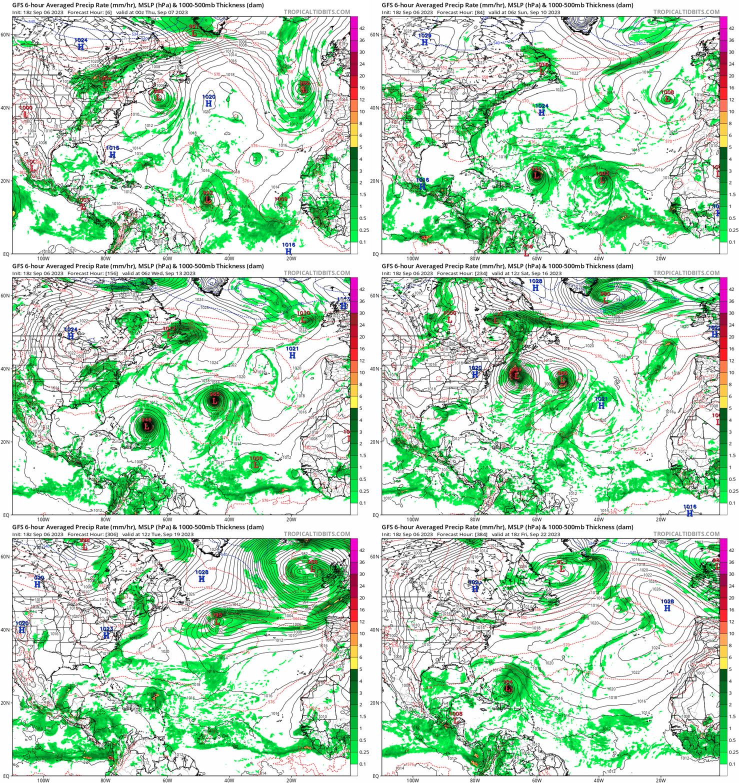
#529 Postby Blown Away » Wed Sep 06, 2023 8:05 pm

Image

GFS is the king of modeling fujiwhara hurricanes.
2 likes   
Hurricane Eye Experience: David 79, Irene 99, Frances 04, Jeanne 04, Wilma 05... EYE COMING MY WAY IN 2024…
Hurricane Brush Experience: Andrew 92, Erin 95, Floyd 99, Matthew 16, Irma 17, Ian 22, Nicole 22…

Dsci4
Tropical Low
Tropical Low
Posts: 15
Joined: Fri Sep 01, 2023 2:32 pm

Re: ATL: LEE - Models

#530 Postby Dsci4 » Wed Sep 06, 2023 8:30 pm

Blown Away wrote:[url]https://i.postimg.cc/sgVZdP5C/gfs-mslp-pcpn-atl-fh6-384.gif [/url]

GFS is the king of modeling fujiwhara hurricanes.


Fujiwhara special but all I can look at is a 984mb storm sitting just north of the islands under a high pressure ridge :P
4 likes   

jlauderdal
S2K Supporter
S2K Supporter
Posts: 7177
Joined: Wed May 19, 2004 5:46 am
Location: NE Fort Lauderdale
Contact:

Re: RE: Re: ATL: LEE - Models

#531 Postby jlauderdal » Wed Sep 06, 2023 8:46 pm

Dsci4 wrote:
Blown Away wrote:[url]https://i.postimg.cc/sgVZdP5C/gfs-mslp-pcpn-atl-fh6-384.gif [/url]

GFS is the king of modeling fujiwhara hurricanes.


Fujiwhara special but all I can look at is a 984mb storm sitting just north of the islands under a high pressure ridge :P
But its run to run accuracy has improved
1 likes   

Ianswfl
Category 1
Category 1
Posts: 482
Joined: Thu Mar 23, 2023 11:11 pm

Re: ATL: LEE - Models

#532 Postby Ianswfl » Wed Sep 06, 2023 8:50 pm

18z GFS ensembles another SW shift.
1 likes   

User avatar
TheDreamTraveler
Category 2
Category 2
Posts: 641
Joined: Sun Aug 22, 2010 3:10 am
Location: PA

Re: ATL: LEE - Models

#533 Postby TheDreamTraveler » Wed Sep 06, 2023 9:16 pm

Here's a better look at the 12z Euro from earlier with the 500mb at the end of its run. Really interested to see what the 0z shows later tonight. It's also funny that the euro was showing it moving northeast and out a few days ago and now the end of its run is showing it moving northwest towards the coast. And yet some people will still say this storm is a done deal and isn't effecting anyone. This is going to be a long week lol

 https://twitter.com/WeatherNut27/status/1699377900527493139


1 likes   

IsabelaWeather
Category 1
Category 1
Posts: 287
Age: 35
Joined: Tue Jul 07, 2020 7:29 am
Location: Isabela, Puerto Rico

Re: ATL: LEE - Models

#534 Postby IsabelaWeather » Wed Sep 06, 2023 10:02 pm

To add credit to the model trends today, the NHC discussion at 11pm EDT nudged their track west from day 3 on.

This is getting interesting here, if the ridge build in a bit more PR could get into some of the rain bands which would be exciting as long as the core stays off shore.
2 likes   

User avatar
ThunderForce
Tropical Storm
Tropical Storm
Posts: 208
Age: 25
Joined: Tue Sep 27, 2022 6:20 pm
Location: Calhoun County, Florida

Re: ATL: LEE - Models

#535 Postby ThunderForce » Wed Sep 06, 2023 10:02 pm

These shifts in the model ensembles today are concerning to say the least.
Last edited by ThunderForce on Wed Sep 06, 2023 10:50 pm, edited 1 time in total.
1 likes   
Please refer to the NWS, NHC, SPC or a professional meteorologist for information and decision making during storms.

Tekken_Guy
Tropical Storm
Tropical Storm
Posts: 135
Joined: Fri Sep 01, 2017 8:08 pm

Re: ATL: LEE - Models

#536 Postby Tekken_Guy » Wed Sep 06, 2023 10:17 pm

How is NJ looking?
1 likes   

User avatar
Hybridstorm_November2001
S2K Supporter
S2K Supporter
Posts: 2811
Joined: Sat Aug 21, 2004 2:50 pm
Location: SW New Brunswick, Canada
Contact:

Re: ATL: LEE - Models

#537 Postby Hybridstorm_November2001 » Wed Sep 06, 2023 10:17 pm

Blown Away wrote:[url]https://i.postimg.cc/sgVZdP5C/gfs-mslp-pcpn-atl-fh6-384.gif [/url]

GFS is the king of modeling fujiwhara hurricanes.


I love this run. :sun: Hopefully, it will keep trending further SE with time and miss all coastal locations then head OTS.
2 likes   

User avatar
SouthFLTropics
Category 5
Category 5
Posts: 4236
Age: 49
Joined: Thu Aug 14, 2003 8:04 am
Location: Port St. Lucie, Florida

Re: ATL: LEE - Models

#538 Postby SouthFLTropics » Wed Sep 06, 2023 10:21 pm

For what it’s worth, 00z ICON is slower and further south than the 18z.


Sent from my iPhone using Tapatalk
2 likes   
Fourth Generation Florida Native

Personal Storm History: David 79, Andrew 92, Erin 95, Floyd 99, Irene 99, Frances 04, Jeanne 04, Wilma 05, Matthew 16, Irma 17, Ian 22, Nicole 22, Milton 24

User avatar
SouthFLTropics
Category 5
Category 5
Posts: 4236
Age: 49
Joined: Thu Aug 14, 2003 8:04 am
Location: Port St. Lucie, Florida

Re: ATL: LEE - Models

#539 Postby SouthFLTropics » Wed Sep 06, 2023 10:31 pm

ICON brings this north of Puerto Rico and slows it down to a crawl… barely moving.


Sent from my iPhone using Tapatalk
2 likes   
Fourth Generation Florida Native

Personal Storm History: David 79, Andrew 92, Erin 95, Floyd 99, Irene 99, Frances 04, Jeanne 04, Wilma 05, Matthew 16, Irma 17, Ian 22, Nicole 22, Milton 24

IcyTundra
Category 5
Category 5
Posts: 1205
Joined: Mon Jun 07, 2021 9:32 pm
Location: Dickinson, Texas

Re: ATL: LEE - Models

#540 Postby IcyTundra » Wed Sep 06, 2023 10:35 pm

Tekken_Guy wrote:How is NJ looking?


Too early to say but people in NJ need to keep an eye on Lee for sure. Hopefully by the end of the weekend we will have a better idea of what Lee will do.
1 likes   


Return to “2023”

Who is online

Users browsing this forum: No registered users and 29 guests