ATL: MILTON - Post-Tropical - Discussion

Moderator: S2k Moderators

Message
Author
User avatar
cheezyWXguy
Category 5
Category 5
Posts: 6091
Joined: Mon Feb 13, 2006 12:29 am
Location: Dallas, TX

Re: ATL: MILTON - Post-Tropical - Discussion

#5421 Postby cheezyWXguy » Thu Oct 10, 2024 10:05 pm

Teban54 wrote:A few other meteorological records of Milton that I haven't seen people mentioning yet:

  • Milton and Michael are the only Category 5 hurricanes in October and November outside of the Caribbean. As I mentioned during Kirk, there were only 6 other official October-November Cat 5s on record: Cuba 1924, Cuba 1932, Hattie, Mitch, Wilma, Matthew. All of them attained Cat 5 intensity in the Caribbean, and all but Matthew did it in Western Caribbean.
    • Cuba 1924 did make landfall in Cuba as a Cat 5 and emerge into the Gulf thereafter, but it probably didn't exist within the Gulf at Cat 5 intensity.
    • If you believe Kirk was a Cat 5 or that it may be upgraded post-season, it and Milton and Michael would be the only three Oct-Nov Cat 5s outside of the Caribbean.
  • How do you define Bay of Campeche? Milton's 897 mb peak was just to the north of it. It's the strongest hurricane that ever got close to BoC: no other Cat 5s had tracked within 2 degrees north of Merida at that intensity. The only Cat 4 to have done so was Inez (115 kt). The strongest hurricane that's unambiguously within BoC was Karl 2010 (Cat 3, 110 kt).

One more to add to the list - as far as I know, there has never been a cat5 that has moved south of due east in the Atlantic before. In fact, correct me if I’m wrong but I don’t think there’s ever been one in the northern hemisphere that’s done that.
5 likes   

User avatar
Xyls
Tropical Storm
Tropical Storm
Posts: 162
Joined: Thu Sep 07, 2023 3:48 pm
Location: New Brunswick, Canada

Re: ATL: MILTON - Hurricane - Discussion

#5422 Postby Xyls » Thu Oct 10, 2024 10:49 pm

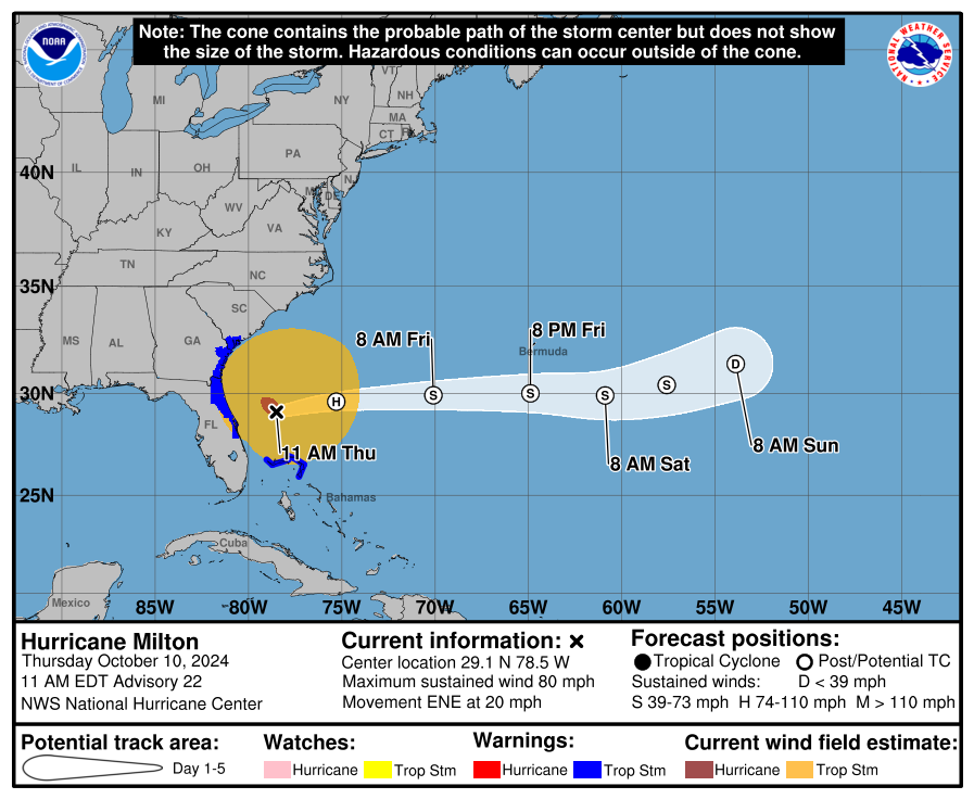
Teban54 wrote:When was the last time a white H (extratropical storm with hurricane-force winds) was shown on a forecast cone?

https://i.postimg.cc/25bXVD1m/091546-5day-exp-Cone.png


Fiona I believe? And she made landfall as a Category 2 equivalent extratropical cyclone. Originally some models had suggested she would've made landfall as a Category 3 equivalent one with a MB in the low 920s and even the high 910s which is almost category 5 type pressure but that didn't happen. But was still crazy what did end up verifying.

Hurricane strength extratropical systems aren't that rare in the North Atlantic. Which is why I commented how in many ways it was very odd to see Milton transitioning to extratropical so far south. In fact, I'm curious if Milton is the most southern extratropical transition that has ever been recorded? If not what is it? The extratropical nature and early transition is also why his tornado outbreak was probably so potent. And in the end I think is what Milton may end up being most remembered for. He is well on his way to retirement though along with Beryl and Helene from this system. Milton will be one of the oddest Category 5 of all times, if not the oddest, and many things that happened are pretty unique to him as far as Category 5 hurricanes go. We will most likely never see a system like him again during our lifetimes. However, due to his uniqueness I'm sure he will be subject to many meteorological studies in the future.

Image
3 likes   
Not a professional meteorologist. Please refer to NHC forecasts for official information/advice relating to tropical systems.

Poonwalker
Category 1
Category 1
Posts: 270
Joined: Tue Sep 20, 2022 11:12 am

Re: ATL: MILTON - Post-Tropical - Discussion

#5423 Postby Poonwalker » Thu Oct 10, 2024 11:36 pm

Second update and thoughts: Seminole and Oldsmar here. Townhouse I have is fine and is tied into Mease Countryside Hospitals power grid. 28 year rcord of never having lost power survives! My brother is in there now because they lost power in their Dunedin home again (Helene was for 3 days without). Seminole home has a natural gas fed Generac which is holding us steady so far. It runs 2 central ACs, 2 fridges, freezer, and the lights etc. it’s a godsend really. I rode the storm out in Seminole house and we did well, 6 big oak branches broke off and neighbors roof lost some shingles, we have a tile roof and it was fine. I helped out my stepson whose mother had a tree come down on her shed and power line. We set up 2 generators and 2 window AC units. Lots of tree damage in this one and saw several power lines down. Worse than Irma, I expect much longer power losses than that storm had. We obviously dodged the bullet due to shear. Even reports from Sarasota from the mayor show the surge was less than predicted. That is not to downplay the damage this caused, perhaps it’s obvious, but a strengthening storm or if Milton held its cat 5 status to landfall the damage would have been unbelievable. Shear is my best friend, even if it makes the storms look uglier lol. The uglier the better on approach!
Last edited by Poonwalker on Fri Oct 11, 2024 10:06 am, edited 3 times in total.
3 likes   

kassi
Tropical Storm
Tropical Storm
Posts: 131
Joined: Sun Aug 23, 2020 6:13 pm
Location: Beaumont, TX

Re: ATL: MILTON - Hurricane - Discussion

#5424 Postby kassi » Thu Oct 10, 2024 11:42 pm

jabman98 wrote:
kassi wrote: I'm in extreme SETX and I feel like it would have been worse here. Heck, nearly 3 million lost power for cat 1 Beryl and that was just in the Houston area. I don't know how long the outages lasted, but for one relative it was well over a week. I can only assume they have underground power in Florida.

Some of that was Centerpoint's failure to maintain areas around lines, like trimming trees, etc. Had they been doing that as they were supposed to do the power outages would not have been as bad. I talked to linemen in from Arkansas in my neighborhood after Beryl who were kind of taken aback by just how many trees there were on lines. They said it was way more complicated to work through than they'd expected. And this was after the derecho in May when we'd had a lot of trees/limbs down and were without power for a week.

Underground lines seem to be less vulnerable to hurricanes and trees on lines but maintaining the lines and clearances around lines would help.

Thanks for the explanation. We have Entergy over here, and lose power easily in strong storms, not necessarily tropical. It's crazy to me to see how many people maintained power under such terrible conditions. For Beryl, I had relatives stay with me over a week because they had no electricity.
2 likes   

User avatar
jasons2k
Storm2k Executive
Storm2k Executive
Posts: 8235
Age: 51
Joined: Wed Jul 06, 2005 12:32 pm
Location: The Woodlands, TX

Re: ATL: MILTON - Post-Tropical - Discussion

#5425 Postby jasons2k » Thu Oct 10, 2024 11:48 pm

jabman98 wrote:
kassi wrote: I'm in extreme SETX and I feel like it would have been worse here. Heck, nearly 3 million lost power for cat 1 Beryl and that was just in the Houston area. I don't know how long the outages lasted, but for one relative it was well over a week. I can only assume they have underground power in Florida.

Some of that was Centerpoint's failure to maintain areas around lines, like trimming trees, etc. Had they been doing that as they were supposed to do the power outages would not have been as bad. I talked to linemen in from Arkansas in my neighborhood after Beryl who were kind of taken aback by just how many trees there were on lines. They said it was way more complicated to work through than they'd expected. And this was after the derecho in May when we'd had a lot of trees/limbs down and were without power for a week.

Underground lines seem to be less vulnerable to hurricanes and trees on lines but maintaining the lines and clearances around lines would help.

I think the ‘lack of trimming’ aspect was way overblown/hyped on social media after Beryl.

CenterPoint began a very aggressive tree-trimming campaign after Ike. But when you trim to a 25’ clearance and you have a canopy of 80-foot tall pine trees, there is only so much you can do. I don’t think anyone would care for the appearance of clear-cutting a 80-100’ clearance around every power line. It’s impractical, too. At some point, there is a compromise between 100% reliability and what’s cost-effective to maintain.
2 likes   

MarioProtVI
Category 4
Category 4
Posts: 932
Age: 23
Joined: Sun Sep 29, 2019 7:33 pm
Location: New Jersey

Re: ATL: MILTON - Post-Tropical - Discussion

#5426 Postby MarioProtVI » Fri Oct 11, 2024 12:52 am

What a historic storm and certainly one for the record books. The first sub-900 I’ve tracked in this basin (I was only 4 when the last one occurred!), and that period Monday morning where Milton just exploded was truly insane. Even more so when I went to bed around 2 am with a Cat 2, woke up around 5 hours later to a high end Cat 3, and then after I took an exam came out to a Cat 5, all in the span of 10 or so hours. :double: Very sad for the extreme damage done to Florida again, but at least it wasn’t the worst-case scenario - though I consider the so-called Tampa shield to have been officially breached by a major hurricane since it did get the eyewall and most intense winds as Milton made landfall. Also extremely ironic it made landfall 6 years to the day after its predecessor did so in Florida, also peaking as a Cat 5. Insane.
8 likes   

caneman
Category 5
Category 5
Posts: 1446
Joined: Fri Sep 05, 2014 5:44 am
Location: Clearwater Beach, Fl

Re: ATL: MILTON - Post-Tropical - Discussion

#5427 Postby caneman » Fri Oct 11, 2024 2:49 am

What a crazy 2 week period. Saw Helene's surge come in 1st hand. Many of my neighbors lost everything. Many haven't even been back home yet. Then Milton come thru with winds up to 102 that feature high end winds and torrential flooding rain. I have no idea how much. 20 plus or up to 30?. Milton took down trees and power lines in our neighborhood. The rain was so intense that it washed out some of my neighbors back yards. And destroyed see walls and docks by the land sliding down. All of these things have never really been experienced to this level of magnitude before. As this one hit when we had massive mounds of debris all around us. At least people will stop saying the Tampa-St. Pete-Clearwater shield or that the Indian burial grounds are protecting us. It looks like a nuclear bomb went off around us. I asked my wife to imagine if I told you it would look like this 2 months ago. She would have thought I was off my rocker. I type this without power but blessed I have Verizon and not ATT OR TMOBILE. I just got my phone working again as it got wet from doing last minute flooding protection on the house. I could tell it was going to be tremendous rainfall from the amount we got just before the storm even got here. The Northern eyewall of a hurricane is no joke! Bottom line is preparation works even when you think it's just a remote chance. God Bless to all. Don't know when I'll see my neighbors again or family that's displaced.
8 likes   

User avatar
xtyphooncyclonex
Category 5
Category 5
Posts: 3857
Age: 23
Joined: Sat Dec 08, 2012 9:07 am
Location: Cebu City
Contact:

Re: ATL: MILTON - Post-Tropical - Discussion

#5428 Postby xtyphooncyclonex » Fri Oct 11, 2024 3:33 am

Is Milton also the strongest storm to strike Sarasota or anywhere this close to Tampa?
0 likes   
REMINDER: My opinions that I, or any other NON Pro-Met in this forum, are unofficial. Please do not take my opinions as an official forecast and warning. I am NOT a meteorologist. Following my forecasts blindly may lead to false alarm, danger and risk if official forecasts from agencies are ignored.

User avatar
kevin
Category 5
Category 5
Posts: 2554
Age: 26
Joined: Wed Aug 28, 2019 4:35 am

Re: ATL: MILTON - Post-Tropical - Discussion

#5429 Postby kevin » Fri Oct 11, 2024 3:59 am

xtyphooncyclonex wrote:Is Milton also the strongest storm to strike Sarasota or anywhere this close to Tampa?


If you take take a point centered on Tampa with a radius the distance between Tampa and Sarasota then the 1921 Tampa Bay hurricane is the only one (since 1851) that also made landfall as a major hurricane in this region. Specifically, it made landfall just north of Tampa as a 100 kt category 3. With 105 kt Milton is thus the strongest landfalling hurricane this close to Tampa since 1851 and also the strongest to strike Sarasota. However, if you take even older records into account the 1848 Tampa Bay hurricane most likely hit the region as a category 4 hurricane.
5 likes   

blueskies
Tropical Low
Tropical Low
Posts: 38
Joined: Tue Sep 03, 2019 2:06 pm

Re: ATL: MILTON - Post-Tropical - Discussion

#5430 Postby blueskies » Fri Oct 11, 2024 6:14 am

About 5 or 6 power crew type trucks stayed in parking lot of Lakeland area hotel all day long yesterday. Just left this morning.

Heard, but can not confirm, that a Publix in Plant City will be opening this morning and that an area near Kathleen Rd. in Lakeland has power.
1 likes   

caneman
Category 5
Category 5
Posts: 1446
Joined: Fri Sep 05, 2014 5:44 am
Location: Clearwater Beach, Fl

Re: ATL: MILTON - Post-Tropical - Discussion

#5431 Postby caneman » Fri Oct 11, 2024 6:20 am

xtyphooncyclonex wrote:Is Milton also the strongest storm to strike Sarasota or anywhere this close to Tampa?


People always reference Tampa for our area but St. Pete was even closer and Bradenton is also part of the metro. Some consider Sarasota to part of the metro but maybe not as much as they used to. The landfall was actually just about 30 miles south as a crow flies and not driving miles. The worse winds were In the Northern sector, worse surge in the southern sector. It's the strongest anyone alive today has experienced in this area.
5 likes   

blueskies
Tropical Low
Tropical Low
Posts: 38
Joined: Tue Sep 03, 2019 2:06 pm

Re: ATL: MILTON - Hurricane - Discussion: Makes landfall near Siesta Key in Sarasota county / 120 mph

#5432 Postby blueskies » Fri Oct 11, 2024 6:45 am

CronkPSU wrote:roof is coming off the Trop (Tropicana Field in St Pete, home of the Rays)

https://x.com/bc_johnson/status/1844207 ... FezRDDrNhw


During earlier phases of the storm and news that Port Charlotte was receiving impacts, I wondered if the spring training facility would be damaged again. Any news on the Port Charlotte facility?
1 likes   

User avatar
Category5Kaiju
Category 5
Category 5
Posts: 4051
Joined: Thu Dec 24, 2020 12:45 pm
Location: Seattle

Re: ATL: MILTON - Post-Tropical - Discussion

#5433 Postby Category5Kaiju » Fri Oct 11, 2024 6:47 am

cheezyWXguy wrote:
Teban54 wrote:A few other meteorological records of Milton that I haven't seen people mentioning yet:

  • Milton and Michael are the only Category 5 hurricanes in October and November outside of the Caribbean. As I mentioned during Kirk, there were only 6 other official October-November Cat 5s on record: Cuba 1924, Cuba 1932, Hattie, Mitch, Wilma, Matthew. All of them attained Cat 5 intensity in the Caribbean, and all but Matthew did it in Western Caribbean.
    • Cuba 1924 did make landfall in Cuba as a Cat 5 and emerge into the Gulf thereafter, but it probably didn't exist within the Gulf at Cat 5 intensity.
    • If you believe Kirk was a Cat 5 or that it may be upgraded post-season, it and Milton and Michael would be the only three Oct-Nov Cat 5s outside of the Caribbean.
  • How do you define Bay of Campeche? Milton's 897 mb peak was just to the north of it. It's the strongest hurricane that ever got close to BoC: no other Cat 5s had tracked within 2 degrees north of Merida at that intensity. The only Cat 4 to have done so was Inez (115 kt). The strongest hurricane that's unambiguously within BoC was Karl 2010 (Cat 3, 110 kt).

One more to add to the list - as far as I know, there has never been a cat5 that has moved south of due east in the Atlantic before. In fact, correct me if I’m wrong but I don’t think there’s ever been one in the northern hemisphere that’s done that.


Indeed. Quite comparable with Mitch when it moved southward as a Category 5 and Lenny as it moved eastward through the Caribbean as a Category 4. Milton's track was something else.
6 likes   
Unless explicitly stated, all info in my posts is based on my own opinions and observations. Tropical storms and hurricanes can be extremely dangerous. Do not think you can beat Mother Nature. Refer to an accredited weather research agency or meteorologist if you need to make serious decisions regarding an approaching storm.

MEANINGLESS_NUMBERS
Category 1
Category 1
Posts: 325
Joined: Mon Nov 02, 2020 1:43 pm

Re: ATL: MILTON - Post-Tropical - Discussion

#5434 Postby MEANINGLESS_NUMBERS » Fri Oct 11, 2024 6:47 am

Rain from the post-tropical remnants will be impacting Bermuda today. Forecast is 15-25 knots with gusts to 35. Local radar has been down all week unfortunately.
0 likes   
Emily '87, Felix '95, Gert '99, Fabian '03, Humberto '19, Paulette '20, Teddy '20, Fiona '22, Lee '23, Ernesto '24

User avatar
toad strangler
S2K Supporter
S2K Supporter
Posts: 4543
Joined: Sun Jul 28, 2013 3:09 pm
Location: Earth
Contact:

Re: ATL: MILTON - Post-Tropical - Discussion

#5435 Postby toad strangler » Fri Oct 11, 2024 7:12 am

I feel extremely lucky. At least five people were killed just 5 miles from me in Fort Pierce by one of these tornadoes. This was a feeder band that will live in infamy.
7 likes   

User avatar
Teban54
Category 5
Category 5
Posts: 3168
Joined: Sat May 19, 2018 1:19 pm

Re: ATL: MILTON - Post-Tropical - Discussion

#5436 Postby Teban54 » Fri Oct 11, 2024 7:31 am

5 likes   

User avatar
NDG
S2K Supporter
S2K Supporter
Posts: 15444
Joined: Sun Jul 09, 2006 10:14 pm
Location: Orlando, FL

Re: ATL: MILTON - Hurricane - Discussion

#5437 Postby NDG » Fri Oct 11, 2024 8:28 am

USTropics wrote:
Craters wrote:
underthwx wrote:Its almost magic what the NHC does.....I hope everyone affected are safe....and here's to blue skies!....

Yep. It seems that after almost every storm, Cycloneye or someone else rightfully points out how good the NHC's track was. Not always, but enough to bet on comfortably. Still, before landfall,there are the dozens of people on the board with the "What are they looking at??!," or "They should have adjusted it in the 11:00 update," or smilar comments. I guess questioning and what-if'ing the official track is part of the attraction and spirit of S2K, but, when push comes to shove, it sure is hard not to respect the OFCL track.

Of course, then there's the ICON...


As Milton is now extra tropical, wanted to take a numerical look at some of the verification scores.

In terms of track error, here are the verification scores for mean absolute positional error:
https://i.imgur.com/lvMFyur.png

NHC/official forecast and TVCN again performed really well in the long range (96-120) hour track. While Helene was one the very rare times the TVCN and NHC track underperformed compared to the deterministic models, you can't really do much better on the long range forecast here. ECMWF and HWRF also did really good with the track (HWRF has been doing much better with track this year, small virtual tear to its retirement in November).

Short term forecast period (24-72 hours), the CTCX has great scores relative to the other models in part due to it being the only model that picked up on the early dive towards the Yucatan peninsula. Its ultimate track was too far north, but it continues to also perform well for strong hurricanes.

Now on to the intensity verification scores. As you can imagine, this was a very difficult storm for the models to forecast (and in general, intensity is much more difficult to forecast compared to track, which has more to do with synoptic scale features). There's a universal under forecasting of intensity by ALL the models through 96 hours essentially, then we start to see our intensity biases creep into the hurricane models for 96-120 hours. This was one of the storms where the HAFSA and HAFSB really shined in intensity verification:
https://i.imgur.com/6Zfj3yq.png


Crazy how the CTCX did so great with Milton. I guess with every storm is different, I remember very clearly how with Helene how left biased it was and I think it was the reason why the consensus was for a long time showing the track to go up to Tallahassee.
Last edited by NDG on Fri Oct 11, 2024 8:34 am, edited 1 time in total.
3 likes   

User avatar
NDG
S2K Supporter
S2K Supporter
Posts: 15444
Joined: Sun Jul 09, 2006 10:14 pm
Location: Orlando, FL

Re: ATL: MILTON - Post-Tropical - Discussion

#5438 Postby NDG » Fri Oct 11, 2024 8:33 am

xtyphooncyclonex wrote:Is Milton also the strongest storm to strike Sarasota or anywhere this close to Tampa?


I think the Sarasota/Bradenton airport broke a record for the strongest winds ever recorded since the station was placed there in the 1970s, from a post a pro-Met wrote on X.
It would probably would go way back if the station was older.
2 likes   

User avatar
NDG
S2K Supporter
S2K Supporter
Posts: 15444
Joined: Sun Jul 09, 2006 10:14 pm
Location: Orlando, FL

Re: ATL: MILTON - Post-Tropical - Discussion

#5439 Postby NDG » Fri Oct 11, 2024 8:51 am

Looking back at models definitely the HAFSs for the win. Within 24 hrs they correctly forecasted that right hook by Milton to make landfall near Sarasota after Milton pointing to Pinellas/Tampa Bay during the day making me believe that perhaps the ICON was going to be correct.
Regarding global models the perhaps the ICON for the win for the most consistent or perhaps the Euro. The GFS was too left biased for a long time prior to 24-48 hrs before landfall before adjusting within 24 hrs.
The Global models were too slow on landfall timing with the Euro being the slowest.
The hurricane models were much closer in timing.
6 likes   

dafif
Tropical Wave
Tropical Wave
Posts: 8
Joined: Sun Oct 06, 2024 8:21 pm

Re: ATL: MILTON - Post-Tropical - Discussion

#5440 Postby dafif » Fri Oct 11, 2024 9:00 am

I found this board about 2 years ago and have been following - cannot thank all the hardworking mets and non mets on here enough for all of the information.

I lived in Tampa for 30 + years before moving to Orlando and have so many friends and family up and down the coast from Sarasoata to Tarpon Springs and the information I gleaned for here helped them out tremendously and me here in Orlando as well.

From an observational standpoint, those north of the storm did much better than expected. Friends house in Venice survived but lost pool screen. House in Apollo Beach survived although neighbors house 3 houses down got a lot of damage. Most Tampa friends survived with one house getting a tree on it. Tarpon Springs house no water intrusion from Helene or Milton (they are very lucky)

I lost fence and a few branches in Orlando by airport with 86 mph winds but no lost power. Up north by Lake Mary/Sanford, lots of flooding with Heathrow golf course under water.

Thanks again everyone !
5 likes   


Return to “2024”

Who is online

Users browsing this forum: No registered users and 7 guests