ATL: Tropical Depression Fay

Moderator: S2k Moderators

Message
Author
marciacubed
S2K Supporter
S2K Supporter
Posts: 122
Joined: Tue Jul 22, 2003 11:52 am
Location: Boynton Beach, Fl
Contact:

Re: ATL: Tropical Storm Fay

#5481 Postby marciacubed » Sat Aug 16, 2008 3:17 pm

jinftl wrote:any thoughts on 5pm update track....similar to 11am update or enough of a shift to put a new area in the cone and take some area out?

I think it will continue to shift to the right.
The posts in this forum are NOT official forecast and should not be used as such. They are just the opinion of the poster and may or may not be backed by sound meteorological data. They are NOT endorsed by any professional institution or storm2k.org. For official information, please refer to the NHC and NWS products.[/quote]
0 likes   

User avatar
Extremeweatherguy
Category 5
Category 5
Posts: 11095
Joined: Mon Oct 10, 2005 8:13 pm
Location: Florida

#5482 Postby Extremeweatherguy » Sat Aug 16, 2008 3:18 pm

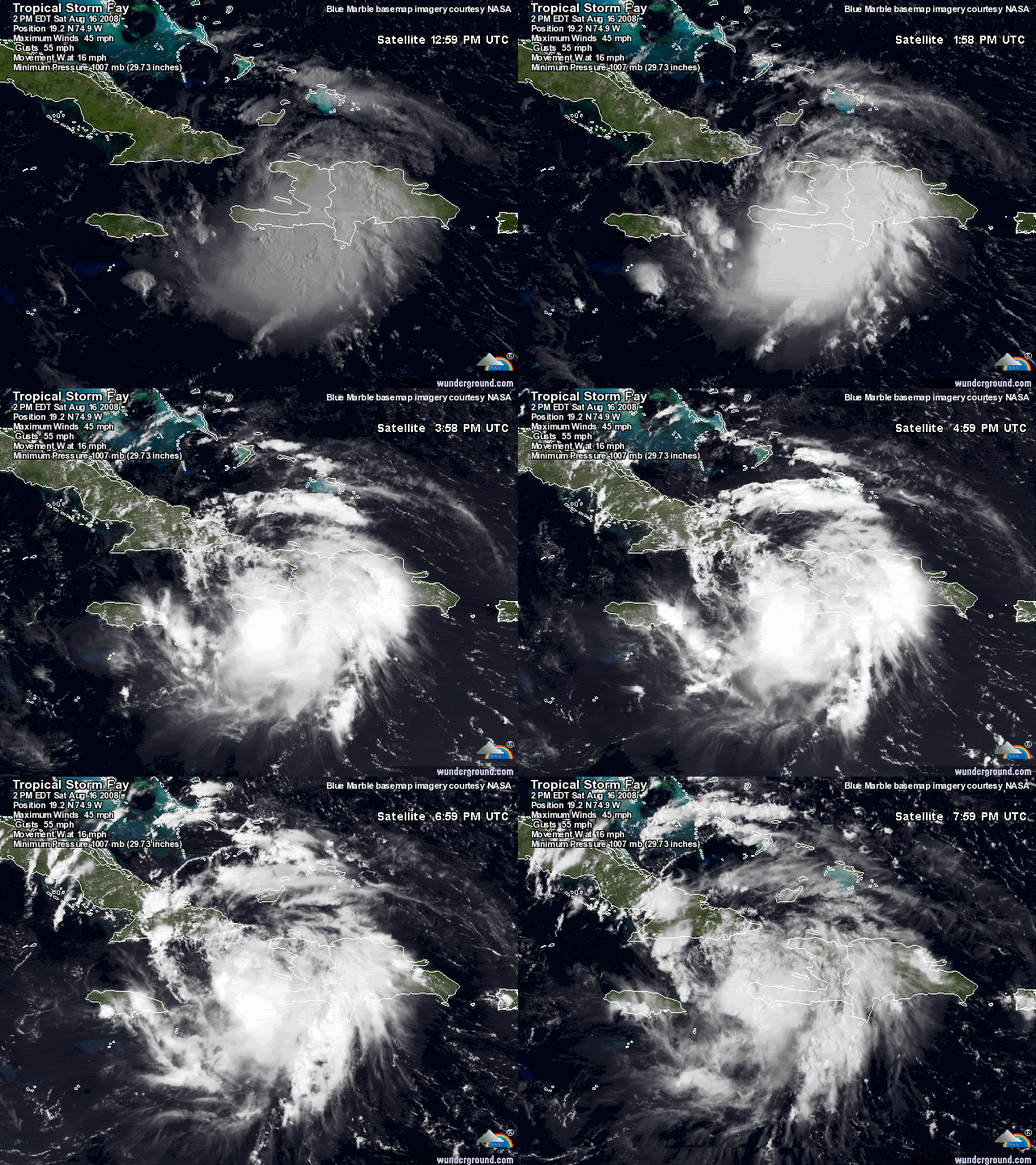
Fay looks to be trying to get her act together this evening. As long as she stays offshore Cuba, I see no reason why this should not steadily strengthen. Though perhaps slightly less likely, I still think it is very possible that this becomes a hurricane before crossing Cuba late Sunday into early Monday.
0 likes   

User avatar
PTPatrick
Category 5
Category 5
Posts: 1831
Joined: Sat Jun 12, 2004 8:38 am

Re: ATL: Tropical Storm Fay

#5483 Postby PTPatrick » Sat Aug 16, 2008 3:18 pm

Ok know its the NAM....BUT...its significant because it has been in the Bahamas and Palm beach so long....42 hour position on the 18z is Key west
0 likes   

User avatar
Noles2006
Category 1
Category 1
Posts: 424
Joined: Thu Jun 08, 2006 9:57 am
Location: Tallahassee, Florida
Contact:

Re: ATL: Tropical Storm Fay

#5484 Postby Noles2006 » Sat Aug 16, 2008 3:19 pm

Blown_away wrote:If you had to draw a path for a storm to be destroyed by land it would not be much different than the path Fay is taking. East to west through PR and Hispanola and IMO looks to be moving down the spine of Cuba, and Cuba is only about 60 miles wide from N/S.


I disagree... I don't think it's going to catch as much of Cuba as you're currently thinking...
0 likes   

Sanibel
Category 5
Category 5
Posts: 10385
Joined: Mon Aug 30, 2004 11:06 pm
Location: Offshore SW Florida

Re: ATL: Tropical Storm Fay

#5485 Postby Sanibel » Sat Aug 16, 2008 3:19 pm

If you had to draw a path for a storm to be destroyed by land it would not be much different than the path Fay is taking. East to west through PR and Hispanola and IMO looks to be moving down the spine of Cuba, and Cuba is only about 60 miles wide from N/S.


I agree, but conditions are good for supporting a land-weakened storm because of no shear etc. Also, recovery-once-back-over-water conditions are excellent as well.
0 likes   

User avatar
DESTRUCTION5
Category 5
Category 5
Posts: 4430
Age: 44
Joined: Wed Sep 03, 2003 11:25 am
Location: Stuart, FL

Re: ATL: Tropical Storm Fay

#5486 Postby DESTRUCTION5 » Sat Aug 16, 2008 3:21 pm

TCmet wrote:
jinftl wrote:any thoughts on 5pm update track....similar to 11am update or enough of a shift to put a new area in the cone and take some area out?


GFDL should be discounted due to poor initialization (as Derek said), so if anything, maybe a nudge back left (west).


So much for the 12z's being better with more data :lol: ....
0 likes   

User avatar
Hurricanewatcher2007
Category 2
Category 2
Posts: 578
Joined: Sat Jul 05, 2008 8:10 pm

Re: ATL: Tropical Storm Fay

#5487 Postby Hurricanewatcher2007 » Sat Aug 16, 2008 3:21 pm

Blown_away wrote:If you had to draw a path for a storm to be destroyed by land it would not be much different than the path Fay is taking. East to west through PR and Hispanola and IMO looks to be moving down the spine of Cuba, and Cuba is only about 60 miles wide from N/S.


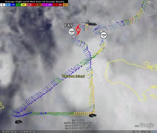
According to the last 2 center fixes by recon the center is WELL south of Cuba. If you want to disagree with recon and say the center is going over cuba then be my guest but facts say other wise!
0 likes   

capepoint
Category 1
Category 1
Posts: 415
Joined: Sat Jul 19, 2008 7:13 pm
Location: Beaufort, NC

#5488 Postby capepoint » Sat Aug 16, 2008 3:22 pm

Sticking with my gut feeling from yesterday.....I still think this is a carolina cruiser. (Cruises along NC sothern outer banks)

In the nearer term..cuts across eastern cuba, then to southern fla exiting into atl no further n than palm beach area, follows gulf stream up to NC, clips or cruises just off cape fear, passes over or very close to cape lookout,ocracoke, and cape hatteras, and heades offshore towards NE.

I still think NO GOM or west FLA run.

I think that the mod shift to the west was a typical swing as the mods shift back and forth before settling down on a course. They always do that when running the first few runs on a new circulation. They will continue east and then settle back west to a line similar to what ive outlined. Just looking at vis sat shows a pretty strong west to east flow across GOM. Since I have no formal weather training, I can get away with saying that I just dont see this turning north and remaining on a northern course bucking that flow without being pushed northeast. Besides, I have no money on this, so if I'm wrong...oh well.

As far as intensity, no more than low cat 1/strong TS at fla landfall, and no more than cat 1 when reaches NC coast.

.... Disclaimer...As before, I have nothing to base this reasoning on, other than a lifetime of fascination and watching hurricanes, studying hurricane history, a sailors feel for weather, and looking at countless models and sat pics today without having any idea of what I'm really seeing. If you accept my forcast as gospel, then you might deserve to die, so you better listen to the nat hurricane center folks that DO have a clue. (is that a good enough disclaimer?)
0 likes   

User avatar
NDG
S2K Supporter
S2K Supporter
Posts: 15507
Joined: Sun Jul 09, 2006 10:14 pm
Location: Orlando, FL

Re: ATL: Tropical Storm Fay

#5489 Postby NDG » Sat Aug 16, 2008 3:22 pm

PTPatrick wrote:Ok know its the NAM....BUT...its significant because it has been in the Bahamas and Palm beach so long....42 hour position on the 18z is Key west


Oh wow, I am impressed, the NAM has finally joined the model consensus, lol.
0 likes   

User avatar
ronjon
Category 5
Category 5
Posts: 4886
Joined: Fri Aug 19, 2005 5:17 pm
Location: Hernando Beach, FL

Re: ATL: Tropical Storm Fay

#5490 Postby ronjon » Sat Aug 16, 2008 3:23 pm

DESTRUCTION5 wrote:
TCmet wrote:
jinftl wrote:any thoughts on 5pm update track....similar to 11am update or enough of a shift to put a new area in the cone and take some area out?


GFDL should be discounted due to poor initialization (as Derek said), so if anything, maybe a nudge back left (west).


So much for the 12z's being better with more data :lol: ....


I think the track will remain unchanged largely due to the consistent runs of GFS at 06Z and 12Z - which is exactly where the 11 am track is.
0 likes   

User avatar
Noles2006
Category 1
Category 1
Posts: 424
Joined: Thu Jun 08, 2006 9:57 am
Location: Tallahassee, Florida
Contact:

Re: ATL: Tropical Storm Fay

#5491 Postby Noles2006 » Sat Aug 16, 2008 3:23 pm

I do not see any reason to shift from the last track put out by the NHC...
0 likes   

User avatar
Blown Away
S2K Supporter
S2K Supporter
Posts: 10252
Joined: Wed May 26, 2004 6:17 am

Re: ATL: Tropical Storm Fay

#5492 Postby Blown Away » Sat Aug 16, 2008 3:24 pm

TCmet wrote:
jinftl wrote:any thoughts on 5pm update track....similar to 11am update or enough of a shift to put a new area in the cone and take some area out?


GFDL should be discounted due to poor initialization (as Derek said), so if anything, maybe a nudge back left (west).

At 5pm a slight E shift with landfall through Keys into Marco Island. I base it on the slight E relocation of the LLC and a more WNW movement at a slower speed, IMO.
0 likes   

Sanibel
Category 5
Category 5
Posts: 10385
Joined: Mon Aug 30, 2004 11:06 pm
Location: Offshore SW Florida

Re: ATL: Tropical Storm Fay

#5493 Postby Sanibel » Sat Aug 16, 2008 3:25 pm

I'm not sure on the right tick. We'll know in a few hours. I'm just saying I'm seeing subtle signs of it possibly occurring. (The convection center is moving more WNW and up Cuba)
0 likes   

TCmet
Professional-Met
Professional-Met
Posts: 106
Age: 44
Joined: Sat Jul 14, 2007 4:00 pm
Location: New York, NY
Contact:

Re: ATL: Tropical Storm Fay

#5494 Postby TCmet » Sat Aug 16, 2008 3:26 pm

DESTRUCTION5 wrote:
TCmet wrote:
jinftl wrote:any thoughts on 5pm update track....similar to 11am update or enough of a shift to put a new area in the cone and take some area out?


GFDL should be discounted due to poor initialization (as Derek said), so if anything, maybe a nudge back left (west).


So much for the 12z's being better with more data :lol: ....


you got me. :D

but in general, the suite of models should be better after the 00Z run... so, the 11pm advisory. including the ingest of the latest recon data (the first center passes).
0 likes   

User avatar
HURAKAN
Professional-Met
Professional-Met
Posts: 46086
Age: 38
Joined: Thu May 20, 2004 4:34 pm
Location: Key West, FL
Contact:

#5495 Postby HURAKAN » Sat Aug 16, 2008 3:26 pm

Image
0 likes   

User avatar
DESTRUCTION5
Category 5
Category 5
Posts: 4430
Age: 44
Joined: Wed Sep 03, 2003 11:25 am
Location: Stuart, FL

Re: ATL: Tropical Storm Fay

#5496 Postby DESTRUCTION5 » Sat Aug 16, 2008 3:26 pm

Blown_away wrote:
TCmet wrote:
jinftl wrote:any thoughts on 5pm update track....similar to 11am update or enough of a shift to put a new area in the cone and take some area out?


GFDL should be discounted due to poor initialization (as Derek said), so if anything, maybe a nudge back left (west).

At 5pm a slight E shift with landfall through Keys into Marco Island. I base it on the slight E relocation of the LLC and a more WNW movement at a slower speed, IMO.


I agree..Just becaue i have noticed the NHC seems to LOVE the GFDL and it has some Euro support too...
0 likes   

User avatar
ronjon
Category 5
Category 5
Posts: 4886
Joined: Fri Aug 19, 2005 5:17 pm
Location: Hernando Beach, FL

Re: ATL: Tropical Storm Fay

#5497 Postby ronjon » Sat Aug 16, 2008 3:27 pm

Wxman57, due you have a motion estimate over the last several hours?
0 likes   

User avatar
cycloneye
Admin
Admin
Posts: 148495
Age: 69
Joined: Thu Oct 10, 2002 10:54 am
Location: San Juan, Puerto Rico

Re: ATL: Tropical Storm Fay

#5498 Postby cycloneye » Sat Aug 16, 2008 3:27 pm

Blown_away wrote:
TCmet wrote:
jinftl wrote:any thoughts on 5pm update track....similar to 11am update or enough of a shift to put a new area in the cone and take some area out?


GFDL should be discounted due to poor initialization (as Derek said), so if anything, maybe a nudge back left (west).

At 5pm a slight E shift with landfall through Keys into Marco Island. I base it on the slight E relocation of the LLC and a more WNW movement at a slower speed, IMO.


North of due west.

Image
0 likes   

User avatar
Bocadude85
Category 5
Category 5
Posts: 2990
Age: 39
Joined: Mon Apr 18, 2005 2:20 pm
Location: Honolulu,Hi

Re: ATL: Tropical Storm Fay

#5499 Postby Bocadude85 » Sat Aug 16, 2008 3:27 pm

so I should be safe here on the se coast of fl?
0 likes   

User avatar
Steve
S2K Supporter
S2K Supporter
Posts: 9628
Joined: Sat Apr 05, 2003 11:41 pm
Location: Gulf of Gavin Newsom

#5500 Postby Steve » Sat Aug 16, 2008 3:28 pm

>>so I should be safe here on the se coast of fl?

Not until the threat officially passes. I don't think anyone can really answer that question but time itself.

Steve
0 likes   


Return to “2008”

Who is online

Users browsing this forum: No registered users and 17 guests