HURAKAN wrote:

For some reason Hurakan the grainyness of that picture made me go "why is he posting a picture of Camille?"then I saw Jamaica.A long weekend coming,geez.
Moderator: S2k Moderators
rockyman wrote:I know this isn't the tropical model thread, but I did want to point out that the 06z HWRF seems to shows the "new" NHC thinking...shows the system moving between NW and NNW to a position EAST of the Isle of Youth...then a NW track to the mouth of the Mississippi River (where it bottoms out SE of the tip to 909mb)...then moves inland right over New Orleans before turning further to the west inland over southern LA


Large dangerous hurricane forecasted into the northern Gulf of Mexico early next week.
Current:
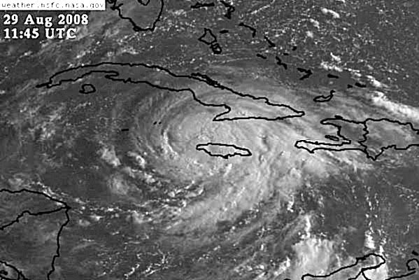
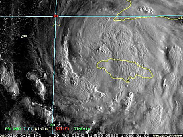
Gustav has been moving across Jamaica overnight and is now moving off to the west of the island. Recon. aircraft is currently investigating the system and has found that the storm has significant grown in size overnight. Gustav continues to move toward the west at around 10mph and a gradual increase in forward speed and turn toward the WNW is expected today. The satellite appearance shows well defined upper level outflow and the recon. reported good banding features it will not take long over the deep warm NW Caribbean waters for Gustav to intensify.
Track:
It all comes down to timing
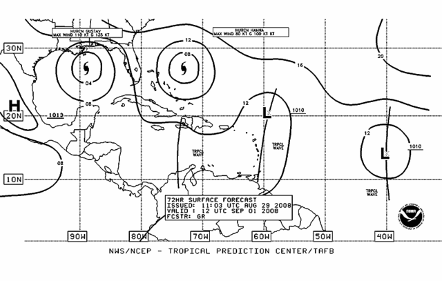
The weak high over FL is producing a slow westward motion at this time this high will weaken and the SW ATL sub-tropical ridge will build into the eastern Gulf of Mexico allowing a WNW to NW motion toward the SE Gulf. There is a break or weakness on the NW side of this developing ridge over the SE US extending back into the Gulf of Mexico for several hundred miles associated with an upper level trough. Based on water vapor images this morning it is very clear this trough is still digging southward toward the northern Yucatan likely being helped by an upper level vortex W of Tampa. This trough may impart a more NNW motion over the NW Caribbean Sea if it hangs on longer than forecast but should begin to lift out to the NE late Saturday allowing Gustav to return to a NW motion on the west side of the sub-tropical high.
The forecast would be fairly straight forward but now the models build in a ridge over the OH valley early next week behind the departing SE US trough and block Gustav’s northward track sound familiar same thing that happened with Fay. This imparts a westward track at or just before landfall and a much greater threat to the upper TX and SW LA coasts.
NHC has adjusted their forecast track westward from 400pm yesterday and slowed the forward motion to split the guidance cluster down the middle. It should be noted that some of the most reliable track guidance still shows a landfall well east of the NHC track toward SE LA and SW MS. The tight clustering seen yesterday afternoon toward SC LA is all but gone this morning and we really do not have any better answers than yesterday.
It is important to note that a larger part of the TX coast has been placed in the forecast error cone this cone is not created by the model spread, but the determined error in past tracks at days 4-5 which are between 150 and 300 miles.
Intensity:
Once Gustav pulls away from Jamaica there is little to impede rapid development. Looking at the water vapor images shows a well defined upper level outflow pattern established over the TC with a 200mb anticyclone producing good venting aloft. SST’s over the NW Caribbean are very warm a deep with some of the highest oceanic heat content in the entire ATL basin. All intensity guidance brings the storm to a major hurricane and a category 4 in the NW Caribbean looks like a safe bet. Once in the Gulf Gustav will track nearly along the loop current and this should maintain its intensity until it reaches the northern Gulf where the heat content decreases and a little SW shear may impact the storm. We have seen numerous powerful hurricane weaken as they approach the US Gulf coast but their effects are still very devastating.
It should be noted that the new NHC guidance package shows a very large hurricane in the Gulf with 34kt (TS force) wind diameter of 250 miles and 50kts winds of 150 miles at forecast point 26.4/88.1 with sustained core winds of 110kts (125mph).
Actions:
Pre disaster declaration was approved by President Bush on Thursday for 61 TX counties.
State of TX is planning for the strike of a category 4 hurricane on the TX coast and has fully activated the state Hurricane Response Plan.
Fuel plan was activated Thursday morning and there has been significant demand increase in the SE/upper TX coast area. Suppliers have all fuel terminals at full distubituion capacity and a flooding the entire retail system with as much fuel as possible. There have been a few supply issues in Harris County but these have been corrected. Today and Saturday the fuel plan will continue to surge to local retail along the coast and begin to push supplies to the evacuation routes and contra-flow corridors.
DPS and TXDOT will begin preparation for mass evacuations of SE TX north of Port Lavaca. TXDOT will begin preparing evacuation routes removing debris and cleaning the US 290 hurrevac traffic lane (outbound shoulder). Contra-flow exchange points on I-10, US 290, I-45, US 37, and US 59 NE will be prepared today and early Saturday. All construction on evacuation routes will be suspended today.
State shelter hubs in Waco, Tyler, El Paso, Dallas, and San Antonio have been fully activated.
Alamo Regional Command was been fully activated to coordinate special needs and possible public evacuations.
Air evacuation of special needs (critical care facilities, hospitals, nursing homes) in the Beaumont/Port Arthur area may begin on Saturday to locations in El Paso and Dallas.
H-120 timeline will likely be adjusted this morning due to forecast track changes overnight and slowing of the potential impact.
Preparations:
Residents should fuel vehicles and maintain 75-100% fuel through the weekend.
Make sure all hurricane supplies are on hand.
Residents in the coastal surge/evacuation zones should review their plans and be fully prepared to leave if ordered to do so.
KWT wrote:DESTRUCTION5, the thing is I really can't disagree with Joe B, I think this is has all the making of becoming a very powerful hurricane, we need to watch for that tight inner core developing again, it only took about 12hrs first time round...
Hurakan, scary!

HURAKAN wrote:
Florida, don't move!
Users browsing this forum: No registered users and 46 guests