Texas winter wx thread (2009-2010)
Moderator: S2k Moderators
Forum rules
 The posts in this forum are NOT official forecast and should not be used as such. They are just the opinion of the poster and may or may not be backed by sound meteorological data. They are NOT endorsed by any professional institution or STORM2K.

The posts in this forum are NOT official forecast and should not be used as such. They are just the opinion of the poster and may or may not be backed by sound meteorological data. They are NOT endorsed by any professional institution or STORM2K.

-
srainhoutx

- S2K Supporter

- Posts: 6919
- Age: 68
- Joined: Sun Jan 14, 2007 11:34 am
- Location: Haywood County, NC
- Contact:
Re:
txagwxman wrote:Need to see the other 12z runs...UKMET/ECMWF.
I totally agree. Nothing is set in stone at this time.
0 likes
Carla/Alicia/Jerry(In The Eye)/Michelle/Charley/Ivan/Dennis/Katrina/Rita/Wilma/Ike/Harvey
Member: National Weather Association
Wx Infinity Forums
http://wxinfinity.com/index.php
Facebook.com/WeatherInfinity
Twitter @WeatherInfinity
Member: National Weather Association
Wx Infinity Forums
http://wxinfinity.com/index.php
Facebook.com/WeatherInfinity
Twitter @WeatherInfinity
-
Portastorm

- Storm2k Moderator

- Posts: 9954
- Age: 63
- Joined: Fri Jul 11, 2003 9:16 am
- Location: Round Rock, TX
- Contact:
Re: Re:
Weatherdude20 wrote:jasons wrote:Dewpoints in the teens up in DFW area. This dry air will allow for some quick evaporative cooling when precip starts to fall.
My point exactly Jason !
Same here in AUS if they hold. Dewpoints now in the upper teens.
0 likes
-
srainhoutx
- S2K Supporter
- Posts: 6919
- Age: 68
- Joined: Sun Jan 14, 2007 11:34 am
- Location: Haywood County, NC
- Contact:
Re: Texas winter wx thread (2009-2010)
DP's in the mid 20's N and W of Houston and slowly falling. IAH is at 31 last report. At my location 24.6 and falling.
Last edited by srainhoutx on Tue Feb 09, 2010 11:27 am, edited 1 time in total.
0 likes
Carla/Alicia/Jerry(In The Eye)/Michelle/Charley/Ivan/Dennis/Katrina/Rita/Wilma/Ike/Harvey
Member: National Weather Association
Wx Infinity Forums
http://wxinfinity.com/index.php
Facebook.com/WeatherInfinity
Twitter @WeatherInfinity
Member: National Weather Association
Wx Infinity Forums
http://wxinfinity.com/index.php
Facebook.com/WeatherInfinity
Twitter @WeatherInfinity
-
HockeyTx82
- S2K Supporter
- Posts: 2774
- Joined: Tue Oct 27, 2009 11:17 am
- Location: Ponder, TX
Re: Re:
Weatherdude20 wrote:jasons wrote:Dewpoints in the teens up in DFW area. This dry air will allow for some quick evaporative cooling when precip starts to fall.
My point exactly Jason !
So does the DFW area look to be in the "fun zone" still for the Thursday-Friday timeframe? I noticed that someone said this run was bad but I don't know where they are talking about (what area).
0 likes
Don't hold me accountable for anything I post on this forum. Leave the real forecasting up to the professionals.
Location: Ponder, TX (all observation posts are this location unless otherwise noted)
Location: Ponder, TX (all observation posts are this location unless otherwise noted)
-
srainhoutx
- S2K Supporter
- Posts: 6919
- Age: 68
- Joined: Sun Jan 14, 2007 11:34 am
- Location: Haywood County, NC
- Contact:
Re: Texas winter wx thread (2009-2010)
GFS is suggesting a mighty deep trough developing for areas E of the Rockies by hour 144. 
0 likes
Carla/Alicia/Jerry(In The Eye)/Michelle/Charley/Ivan/Dennis/Katrina/Rita/Wilma/Ike/Harvey
Member: National Weather Association
Wx Infinity Forums
http://wxinfinity.com/index.php
Facebook.com/WeatherInfinity
Twitter @WeatherInfinity
Member: National Weather Association
Wx Infinity Forums
http://wxinfinity.com/index.php
Facebook.com/WeatherInfinity
Twitter @WeatherInfinity
-
jasons2k

- Storm2k Executive

- Posts: 8290
- Age: 52
- Joined: Wed Jul 06, 2005 12:32 pm
- Location: The Woodlands, TX
Re: Re:
HockeyTx82 wrote:Weatherdude20 wrote:jasons wrote:Dewpoints in the teens up in DFW area. This dry air will allow for some quick evaporative cooling when precip starts to fall.
My point exactly Jason !
So does the DFW area look to be in the "fun zone" still for the Thursday-Friday timeframe? I noticed that someone said this run was bad but I don't know where they are talking about (what area).
Well, it's just too early to tell. But the GFS is notorious for missing shallow layers of cold/dry air just above the surface. The GFS may say it's too warm for sleet but with enough evaporative cooling, sometimes this can lead to a sleet event. Not that it would stick but something to look at.
This is also something one would expect to see in an El Nino pattern with cold air spilling down, but a strong ST Jet blasting overhead.
The jury is still out on this one...just not enough consistency yet.
0 likes
-
srainhoutx
- S2K Supporter
- Posts: 6919
- Age: 68
- Joined: Sun Jan 14, 2007 11:34 am
- Location: Haywood County, NC
- Contact:
Re: Texas winter wx thread (2009-2010)
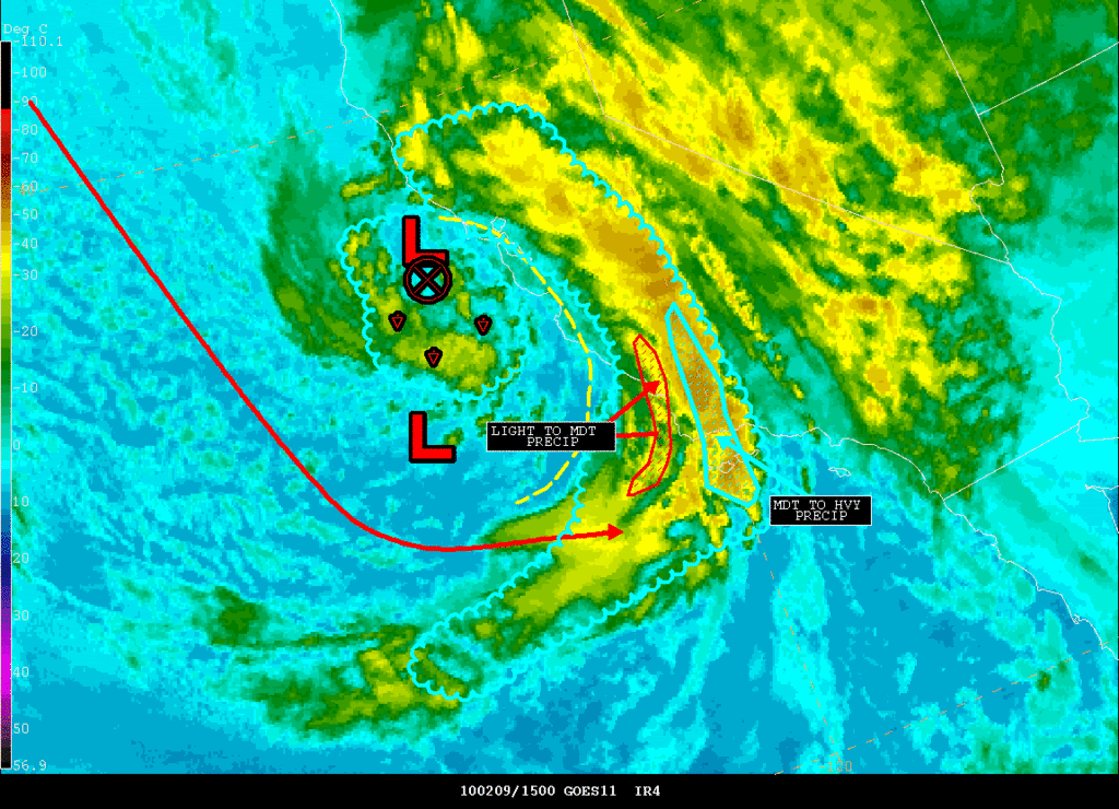
Take a look at what the storm is doing at the moment via Nesdis...
ZCZC NFDSPENES ALL
SPENES
CAZ000-
.
SATELLITE PRECIPITATION ESTIMATES..DATE/TIME 02/09/10 1532Z
SATELLITE ANALYSIS BRANCH/NESDIS---NPPU---TEL.301-763-8678
LATEST DATA USED: GOES-11 1515Z
NOAA AMSU:1038Z/1123Z NASA AMSR-E:1001Z/1140Z
.
LOCATION...CENTRAL AND SOUTHERN CALIFORNIA...
.
ATTN WFOS...SGX...HNX...LOX...
ATTN RFCS...CNRFC...
.
EVENT...ONE MAIN BAND...SMALLER SECOND BAND FOR HEIGHTEN FF THREAT...
.
SATELLITE ANALYSIS AND TRENDS...MAIN ENHANCED BAND DOING ITS THING WITH
GENERAL MODERATE TO LOCAL HVY RAIN. A WAVE MAY HAVE DEVELOPED ON THIS
BAND OVER SANTA BARBARA AND THIS COULD HAVE RAMIFICATION FOR SPEED AND
AMOUNTS FOR VENTURA AND LA COUNTY AND JUST INLAND OVER THE MOUNTAINS FOR
THE NEXT 3-8 HRS. DON'T THINK CHANGES WILL BE SIGNIFICANT BUT MAYBE
AN HR OR TWO OF VERY HVY PRECIP COMPARED WITH AN HR OR SO OF JUST MDT TO
HVY MAYBE THE DIFFERENCE BETWEEN FLOOD AND NO FLOOD. IN ANY CASE MOISTURE
VERY COMPACT AND WILL DELIVER THE HVY RAIN IN A SHORT TIME PERIOD WITH
SHWRS BEHIND AS DRY TONGUE TRIES TO COME SE UNDERNEATH UPPER LOW/ VORT
THAT WAS NOW JUST WNW OF SFO BAY.
WILL CONTINUE TO MONITOR. SATELLITE RAIN ESTIMATES FOR 6HRS RUNNING
ABOUT 0.5" TO 1.0" WITH MOST OCCURRING IN A 3HR PERIOD.
SEE SATELLITE ANALYSIS GRAPHIC SHORTLY ON THE INTERNET AT ADDRESS BELOW...
.
SEE NCEP HPC DISCUSSION AND QPF/S FOR FORECAST.
....NESDIS IS A MEMBER OF 12 PLANET....
0 likes
Carla/Alicia/Jerry(In The Eye)/Michelle/Charley/Ivan/Dennis/Katrina/Rita/Wilma/Ike/Harvey
Member: National Weather Association
Wx Infinity Forums
http://wxinfinity.com/index.php
Facebook.com/WeatherInfinity
Twitter @WeatherInfinity
Member: National Weather Association
Wx Infinity Forums
http://wxinfinity.com/index.php
Facebook.com/WeatherInfinity
Twitter @WeatherInfinity
-
srainhoutx
- S2K Supporter
- Posts: 6919
- Age: 68
- Joined: Sun Jan 14, 2007 11:34 am
- Location: Haywood County, NC
- Contact:
Re: Texas winter wx thread (2009-2010)
Just an FYI from the HPC regarding the GFS 12Z run without the ECMWF, GGEM or UKMET as they have not started...
http://www.hpc.ncep.noaa.gov/discussions/pmdhmd.html
...SYSTEM INITIALLY NEAR THE CALIFORNIA COAST...
PREFERENCE: GFS/00Z ECMWF COMPROMISE
THE NAM BECOMES A SLOW OUTLIER WITH THE UPR LOW COMPARED TO THE
GFS AND MAJORITY OTHER SOLNS FROM TUE NIGHT ONWARD. SOME 09Z
SREF/06Z GEFS MEMBERS DO OFFER POTENTIAL FOR THE SLOWER TIMING
THOUGH. THE NAM HAS YET TO DISPLAY A TREND TOWARD THE MAJORITY
FASTER SOLN BUT GIVEN A TYPICALLY SLOW BIAS WHEN THE NAM IS ON THE
SLOW EDGE OF THE GUIDANCE SPREAD... WOULD FAVOR LEANING AWAY FROM
THE NAM WITH THE UPR SYSTEM AND EVENTUALLY THE SFC LOW THAT TRACKS
OVER THE GULF. AMONG THE NON-NAM GUIDANCE THE GFS BECOMES MORE
SUPPRESSED WITH THE GULF LOW THAN MOST SOLNS ASIDE FROM THE 06Z
GEFS MEAN... WHILE THE 00Z ECMWF/ECMWF ENSEMBLE MEAN AND 12Z UKMET
THRU F72 EARLY FRI SHOW FASTER TIMING THAN THE GFS. THE
ECMWF/UKMET ARE BOTH SLIGHTLY DEEPER THAN THE GFS WITH THE CORE OF
THE SHRTWV ALOFT BY LATE FRI. OVERALL THE GFS FCST APPEARS BETTER
THAN THE NAM... BUT GFS FLOW FROM THE PLAINS TO APLCHNS DOES NOT
COMPARE WELL TO MOST OTHER SOLNS ASIDE FROM THE 06Z GEFS MEAN BY
LATE IN THE FCST. THUS WOULD ULTIMATELY RECOMMEND A GFS/00Z ECMWF
COMPROMISE AS AN ACCEPTABLE STARTING POINT.
http://www.hpc.ncep.noaa.gov/discussions/pmdhmd.html
Last edited by srainhoutx on Tue Feb 09, 2010 11:57 am, edited 1 time in total.
0 likes
Carla/Alicia/Jerry(In The Eye)/Michelle/Charley/Ivan/Dennis/Katrina/Rita/Wilma/Ike/Harvey
Member: National Weather Association
Wx Infinity Forums
http://wxinfinity.com/index.php
Facebook.com/WeatherInfinity
Twitter @WeatherInfinity
Member: National Weather Association
Wx Infinity Forums
http://wxinfinity.com/index.php
Facebook.com/WeatherInfinity
Twitter @WeatherInfinity
-
Portastorm
- Storm2k Moderator
- Posts: 9954
- Age: 63
- Joined: Fri Jul 11, 2003 9:16 am
- Location: Round Rock, TX
- Contact:
Re: Texas winter wx thread (2009-2010)
NWSFO Austin/San Antonio in their mid-morning AFD says "no snow for you Portastorm!"
-----
AREA FORECAST DISCUSSION
NATIONAL WEATHER SERVICE AUSTIN/SAN ANTONIO TX
1048 AM CST TUE FEB 9 2010
.UPDATE...
DRY SURFACE RIDGE CONTINUES TO BUILD INTO S CENTRAL TX THIS
MORNING WITH VARIABLE CLOUDINESS ACROSS THE CWA LIKELY TO INCREASE
THROUGH THE AFTERNOON AND EVENING. SURFACE DEW POINTS THIS
MORNING WERE IN THE MID TO UPPER 20S TO NEAR 30...WITH TEENS TO
THE NORTH IN CENTRAL TX. A 2K LAYER OF FREEZING TEMPERATURES NOTED
ON DRT SOUNDING AROUND 850MB AT 12Z. WARMER TEMPS ABOVE THE
FREEZING LAYER BUT VERY DRY WHICH WILL EASILY COOL BELOW FREEZING
WITH ANY PRECIPITATION FALLING THRU IT. FORECAST SOUNDINGS POINTS
IN THE HILL COUNTRY WED NIGHT INDICATE TEMP/DEW POINT PROFILE
FALLING BELOW FREEZING FOR THE HILL COUNTRY LATE TUE NIGHT INTO
WED BEFORE WARMING ABOVE FREEZING THU MORNING. APPEARS MAINLY A
WIDESPREAD RAIN EVENT FOR THURSDAY AS WARM AIR ADVECTION
DOMINATES. OTHERWISE NO MAJOR CHANGES TO ONGOING FORECAST.
0 likes
-
HockeyTx82
- S2K Supporter
- Posts: 2774
- Joined: Tue Oct 27, 2009 11:17 am
- Location: Ponder, TX
Re: Texas winter wx thread (2009-2010)
Portastorm wrote:NWSFO Austin/San Antonio in their mid-morning AFD says "no snow for you Portastorm!"
-----
AREA FORECAST DISCUSSION
NATIONAL WEATHER SERVICE AUSTIN/SAN ANTONIO TX
1048 AM CST TUE FEB 9 2010
.UPDATE...
DRY SURFACE RIDGE CONTINUES TO BUILD INTO S CENTRAL TX THIS
MORNING WITH VARIABLE CLOUDINESS ACROSS THE CWA LIKELY TO INCREASE
THROUGH THE AFTERNOON AND EVENING. SURFACE DEW POINTS THIS
MORNING WERE IN THE MID TO UPPER 20S TO NEAR 30...WITH TEENS TO
THE NORTH IN CENTRAL TX. A 2K LAYER OF FREEZING TEMPERATURES NOTED
ON DRT SOUNDING AROUND 850MB AT 12Z. WARMER TEMPS ABOVE THE
FREEZING LAYER BUT VERY DRY WHICH WILL EASILY COOL BELOW FREEZING
WITH ANY PRECIPITATION FALLING THRU IT. FORECAST SOUNDINGS POINTS
IN THE HILL COUNTRY WED NIGHT INDICATE TEMP/DEW POINT PROFILE
FALLING BELOW FREEZING FOR THE HILL COUNTRY LATE TUE NIGHT INTO
WED BEFORE WARMING ABOVE FREEZING THU MORNING. APPEARS MAINLY A
WIDESPREAD RAIN EVENT FOR THURSDAY AS WARM AIR ADVECTION
DOMINATES. OTHERWISE NO MAJOR CHANGES TO ONGOING FORECAST.
You know what would be funny is if one of them was reading this board and put that in the AFD for real. I really hope you get something, but how special would you feel being reffered to in a NWS AFD.
0 likes
Don't hold me accountable for anything I post on this forum. Leave the real forecasting up to the professionals.
Location: Ponder, TX (all observation posts are this location unless otherwise noted)
Location: Ponder, TX (all observation posts are this location unless otherwise noted)
-
srainhoutx
- S2K Supporter
- Posts: 6919
- Age: 68
- Joined: Sun Jan 14, 2007 11:34 am
- Location: Haywood County, NC
- Contact:
Re: Texas winter wx thread (2009-2010)
GGEM says not so fast and warm GFS. I just saved the hour 72 chart for entertainment purposes for folks in SE TX and SW LA with the wrap around moisture...

0 likes
Carla/Alicia/Jerry(In The Eye)/Michelle/Charley/Ivan/Dennis/Katrina/Rita/Wilma/Ike/Harvey
Member: National Weather Association
Wx Infinity Forums
http://wxinfinity.com/index.php
Facebook.com/WeatherInfinity
Twitter @WeatherInfinity
Member: National Weather Association
Wx Infinity Forums
http://wxinfinity.com/index.php
Facebook.com/WeatherInfinity
Twitter @WeatherInfinity
-
gboudx

- S2K Supporter
- Posts: 4090
- Joined: Thu Sep 04, 2003 1:39 pm
- Location: Rockwall, Tx but from Harvey, La
Re: Texas winter wx thread (2009-2010)
Portastorm wrote:NWSFO Austin/San Antonio in their mid-morning AFD says "no snow for you Portastorm!"
The dreaded warm air advection. I've seen that kill quite a few DFW winter storms. I think I'll go into expecting it to kill this one as well, and not get any hopes up. Need to put the weather rock outside to be the true predictor.
0 likes
-
southerngale

- Retired Staff

- Posts: 27418
- Joined: Thu Oct 10, 2002 1:27 am
- Location: Southeast Texas (Beaumont area)
hmmm, Portastorm. NWS LCH didn't take out the snow/sleet for this area in their update and even mentioned that the forecast was on track in their brief morning update. I guess they want to see the other models first. I'm sure any mention of snow will be removed in the afternoon package.
0 likes
Please support Storm2k by making a donation today. It is greatly appreciated! Click here: 
 my Cowboys my Rockets my Astros
my Cowboys my Rockets my Astros-
sphelps8681
- Category 2

- Posts: 785
- Joined: Thu Aug 16, 2007 5:37 pm
- Location: Somewhere over the rainbow
Re: Texas winter wx thread (2009-2010)
srainhoutx wrote:GGEM says not so fast and warm GFS. I just saved the hour 72 chart for entertainment purposes for folks in SE TX and SW LA with the wrap around moisture...
I am not able to see the image. Where can I go to see the image.
0 likes
-
Portastorm
- Storm2k Moderator
- Posts: 9954
- Age: 63
- Joined: Fri Jul 11, 2003 9:16 am
- Location: Round Rock, TX
- Contact:
Re: Texas winter wx thread (2009-2010)
Knowing my local NWSFO's skill set are forecasting winter weather, the fact that they are poo-poo'ing snow/ice for this week may not be a bad thing at all!
HockeyTx82, if any of us were referenced in an AFD ... I would be worried.
0 likes

Re: Texas winter wx thread (2009-2010)
gboudx wrote:Portastorm wrote:NWSFO Austin/San Antonio in their mid-morning AFD says "no snow for you Portastorm!"
The dreaded warm air advection. I've seen that kill quite a few DFW winter storms. I think I'll go into expecting it to kill this one as well, and not get any hopes up. Need to put the weather rock outside to be the true predictor.
well there is always the old saying "Thunder in winter, snow in less than a week"
crossing fingers, if not ill give up and wait till next winter and go ahead and get started on the garden...
0 likes
just a guess.......take everything i say with a grain of salt.......check your local NWS for forecast information
-
srainhoutx
- S2K Supporter
- Posts: 6919
- Age: 68
- Joined: Sun Jan 14, 2007 11:34 am
- Location: Haywood County, NC
- Contact:
Re: Texas winter wx thread (2009-2010)
sphelps8681 wrote:srainhoutx wrote:GGEM says not so fast and warm GFS. I just saved the hour 72 chart for entertainment purposes for folks in SE TX and SW LA with the wrap around moisture...
I am not able to see the image. Where can I go to see the image.
http://www.weatheroffice.gc.ca/model_fo ... bal_e.html
These are from the black and white charts.
0 likes
Carla/Alicia/Jerry(In The Eye)/Michelle/Charley/Ivan/Dennis/Katrina/Rita/Wilma/Ike/Harvey
Member: National Weather Association
Wx Infinity Forums
http://wxinfinity.com/index.php
Facebook.com/WeatherInfinity
Twitter @WeatherInfinity
Member: National Weather Association
Wx Infinity Forums
http://wxinfinity.com/index.php
Facebook.com/WeatherInfinity
Twitter @WeatherInfinity
Who is online
Users browsing this forum: No registered users and 52 guests