ATL : TROPICAL DEPRESSION IDA
Moderator: S2k Moderators

Re: ATL : HURRICANE IDA
Do you remember this thread? Development on SW Caribbean? We were very skeptical about it, El Niño year, climatology other false alarms were the arguments that we gave and it ended to be true, that's why we never have to say never. So far the numbers of this season are 11,9,3,2 will it be 11,9,3,3 I don't think so but never say never 
0 likes


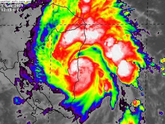

Re: ATL : HURRICANE IDA
Crostorm wrote:

Based on this image, it looks like the center has made landfall. On the latest infrared, it looks convection is weakening around the center, which is another sign of landfall. So it may be downgraded in the next advisory.
0 likes

Re: ATL : HURRICANE IDA
wzrgirl1 wrote:gatorcane wrote:boca wrote:I'm surprised that the models and the NHC at day five looking at that 200mb flow map you posted above.The posts in this forum are NOT official forecast and should not be used as such. They are just the opinion of the poster and may or may not be backed by sound meteorological data. They are NOT endorsed by any professional institution or storm2k.org. For official information, please refer to the NHC and NWS products.
If you look at the latest set of models (models thread), you can see some are already showing the distinct NE/ENE turn at the end. Expect more to follow with perhaps a sharper turn over the next few days. Could very well be a Florida system this time with even some East movement at the end before it is all through.
Can you please post a link to those latest models. Very intrigued over here.
Here's the link.
http://my.sfwmd.gov/sfwmd/common/images ... orm_11.gif
0 likes


Re: ATL : HURRICANE IDA
Gatorcane, what that 200 mb map shows me is a large upper level high over the NW caribbean - probably why the GFDL intensity really explodes. Shear looks close to zero south of 25 deg N.
0 likes

-
wzrgirl1

- S2K Supporter

- Posts: 1360
- Joined: Sat Sep 04, 2004 6:44 am
- Location: Pembroke Pines, Florida
Re: ATL : HURRICANE IDA
If you look at the latest set of models (models thread), you can see some are already showing the distinct NE/ENE turn at the end. Expect more to follow with perhaps a sharper turn over the next few days. Could very well be a Florida system this time with even some East movement at the end before it is all through.[/quote]
Can you please post a link to those latest models. Very intrigued over here.[/quote]
Here's the link.
http://my.sfwmd.gov/sfwmd/common/images ... orm_11.gif[/quote]
Thank you. Seeing a slight curve at the end of that run. Wilmaesque? Yikes!
Can you please post a link to those latest models. Very intrigued over here.[/quote]
Here's the link.
http://my.sfwmd.gov/sfwmd/common/images ... orm_11.gif[/quote]
Thank you. Seeing a slight curve at the end of that run. Wilmaesque? Yikes!
0 likes

Yep certainly looks to be over land, the key now is whether it stays aware from the high mountions a little to the west.
Looks great though, I wouldn't be surprised if it was actually a touch stronger then we think, maybe around 80mph on landfall itself.
Looks great though, I wouldn't be surprised if it was actually a touch stronger then we think, maybe around 80mph on landfall itself.
0 likes
Personal Forecast Disclaimer:
The posts in this forum are NOT official forecast and should not be used as such. They are just the opinion of the poster and may or may not be backed by sound meteorological data. They are NOT endorsed by any professional institution or storm2k.org. For official information, please refer to the NHC and NWS products
The posts in this forum are NOT official forecast and should not be used as such. They are just the opinion of the poster and may or may not be backed by sound meteorological data. They are NOT endorsed by any professional institution or storm2k.org. For official information, please refer to the NHC and NWS products
Re: ATL : HURRICANE IDA
How many of you think this will survive the trek across Nicarugua and Honduras given the very slow forward speed?
0 likes
Depends how close to the shore it stays I think Boca, its very close to the shore and its probably got a good moisture injection on its eastern side, however it is still a fairly tight system so that goes against it.
I think it probably will survive as long as it doesn't get much further west then it is now, probably emerging as a TD barring some freaky Fay-like thing occuring!
I think it probably will survive as long as it doesn't get much further west then it is now, probably emerging as a TD barring some freaky Fay-like thing occuring!
0 likes
Personal Forecast Disclaimer:
The posts in this forum are NOT official forecast and should not be used as such. They are just the opinion of the poster and may or may not be backed by sound meteorological data. They are NOT endorsed by any professional institution or storm2k.org. For official information, please refer to the NHC and NWS products
The posts in this forum are NOT official forecast and should not be used as such. They are just the opinion of the poster and may or may not be backed by sound meteorological data. They are NOT endorsed by any professional institution or storm2k.org. For official information, please refer to the NHC and NWS products


-
TreasureIslandFLGal

- S2K Supporter
- Posts: 1584
- Age: 58
- Joined: Sun Aug 15, 2004 6:16 pm
- Location: Cancun, Mexico (northeast Yucatan coast)
Re: ATL : HURRICANE IDA
Even if it doesn't survive as a hurricane or TS, it may very well spin back up if just a TD emerges into the warm waters of the NW Caribbean.
What concerns me is the approaching front. Better for FL if it goes painfully slow. Then it will either be scooted to the ENE and miss FL altogether once it emerges (sorry Cuba), or else the front will miss the connection altogether and it will then go N or NW (sorry north central GOM). However, I fear that it will get moving a little and be affected by the front.
According to HPC site, which is a good indication of where the fronts will be in CONUS, this looks like it may very well be a Florida storm, but hopefully a much weakened version. See this link, and then you can advance a day or go back a day:
http://www.hpc.ncep.noaa.gov/medr/day6nav_pre.html
0 likes
Chrissy & Ligeia

-
Weatherboy1

- Category 5

- Posts: 1190
- Age: 50
- Joined: Mon Jul 05, 2004 1:50 pm
- Location: Jupiter/Sarasota, FL
Re: ATL : HURRICANE IDA - Models
I would be surprised to see such a far west path -- and/or intensity forecast -- verify this time of year. Remember the models for Irene and how they kept her heading N in the EGOMEX, only to have her eventually head NNE and eject across Florida into the Atlantic? That was in October. We are now in early November. The history of November storms is that they A) Hook to the N and NE and B) that they get sheared apart once they cross 20-ish N.
0 likes

-
TreasureIslandFLGal
- S2K Supporter
- Posts: 1584
- Age: 58
- Joined: Sun Aug 15, 2004 6:16 pm
- Location: Cancun, Mexico (northeast Yucatan coast)
Re: ATL : HURRICANE IDA - Models
So this may impact us here on west coast FL next Wed-Thur. ugh.
If it does, hopefully not until Fri, since I have no more paid days off left this year! -or hopefully it is just a very weak storm and just a big rainy breezy event and nothing more.
If it does, hopefully not until Fri, since I have no more paid days off left this year! -or hopefully it is just a very weak storm and just a big rainy breezy event and nothing more.
0 likes
Chrissy & Ligeia
Re: ATL : HURRICANE IDA
When you look at that loop that Hurrakan posted above it looks like its moving west of due north now.
0 likes
Who is online
Users browsing this forum: No registered users and 6 guests