

Top hurricane sat photos of all time...
Moderator: S2k Moderators
Forum rules

The posts in this forum are NOT official forecasts and should not be used as such. They are just the opinion of the poster and may or may not be backed by sound meteorological data. They are NOT endorsed by any professional institution or STORM2K. For official information, please refer to products from the National Hurricane Center and National Weather Service.
Re: Top hurricane sat photos of all time...
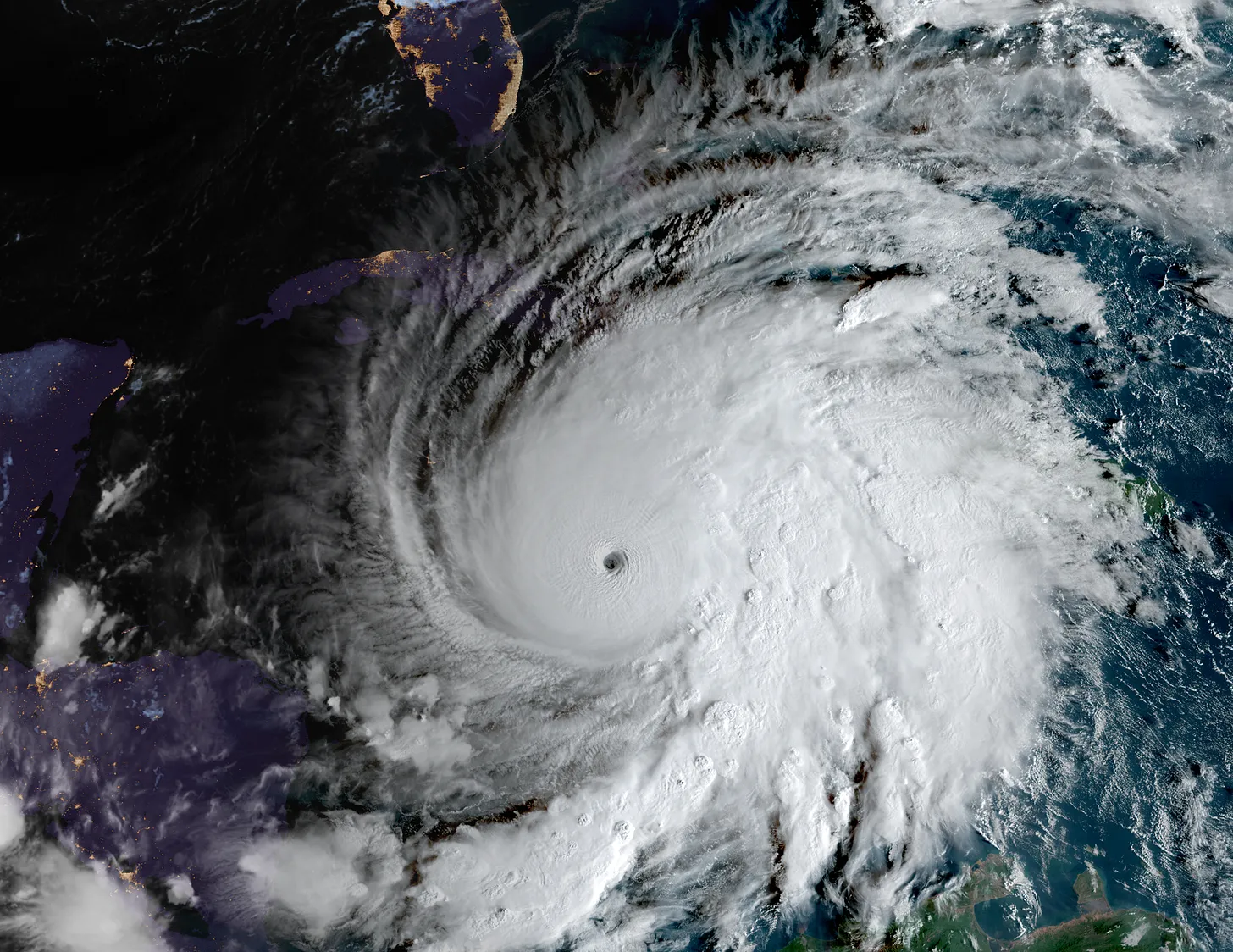
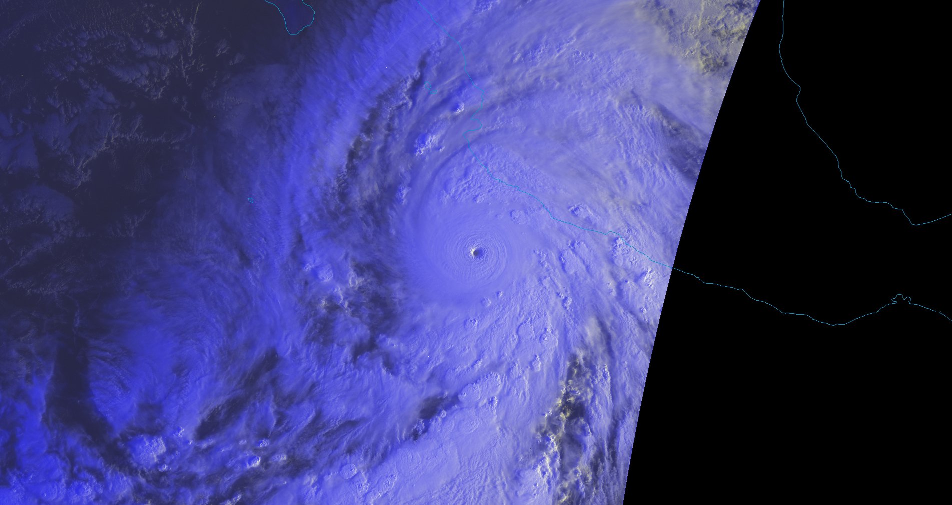
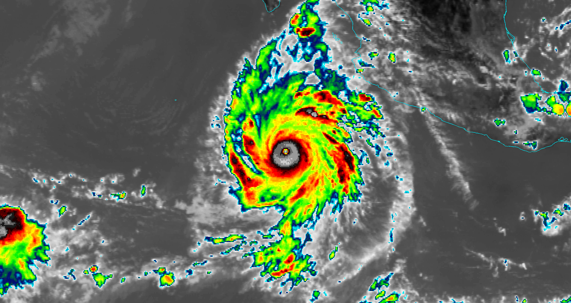
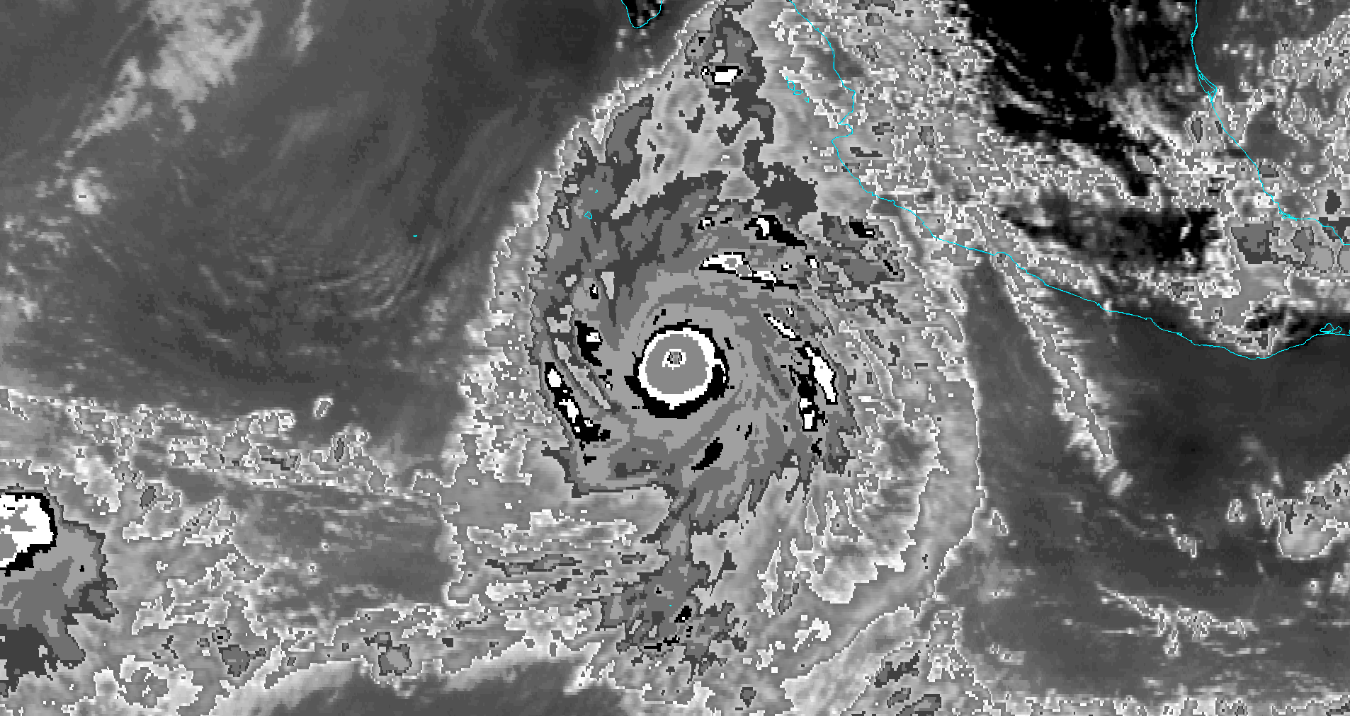
IR imagery of hurricane Melissa at 02:55z, October 28 2025. With a CI# and final T# of 8.5 and a raw T# of 8.6 (by UW-CIMSS Automated Satellite-Based Advanced Dvorak Technique), this is quite possibly the most impressive IR image of a tropical cyclone ever captured in the Atlantic.
11 likes


Re: Top hurricane sat photos of all time...
kevin wrote:IR imagery of hurricane Melissa at 02:55z, October 28 2025. With a CI# and final T# of 8.5 and a raw T# of 8.6 (by UW-CIMSS Automated Satellite-Based Advanced Dvorak Technique), this is quite possibly the most impressive IR image of a tropical cyclone ever captured in the Atlantic.
https://i.imgur.com/geRujY8.jpeg
I may try to track down versions of this frame with other color maps / zooms / GOES bands at some point. Though recon data indicate that Melissa had not yet reached her peak at the time, and it's well past local sunset so there's no VIS imagery, it's an absolutely historic hurricane satellite photo; no storm globally had attained such numbers from ADT before (at least not the raw T8.6; I know Haiyan made CI 8.5).. Just as worth preserving in this thread as the various photos/loops of Melissa's landfall that have already been added, IMO.
6 likes
-
Category5Kaiju

- Category 5

- Posts: 4345
- Joined: Thu Dec 24, 2020 12:45 pm
- Location: Seattle during the summer, Phoenix during the winter
Re: Top hurricane sat photos of all time...
Roses are red
Violets are blue
Peak season's quite tame
But October won't be the same
Violets are blue
Peak season's quite tame
But October won't be the same
7 likes
Unless explicitly stated, all information in my posts is based on my own opinions and observations. Tropical storms and hurricanes can be extremely dangerous. Refer to an accredited weather research agency or meteorologist if you need to make serious decisions regarding an approaching storm.
-
Hurricane2022

- Category 5
- Posts: 2090
- Joined: Tue Aug 23, 2022 11:38 pm
- Location: Araçatuba, Brazil
Re: Top hurricane sat photos of all time...
Major Hurricane 13L (Melissa) - 2025.


Source: Wikimedia Commons.
Source: Wikimedia Commons.
7 likes
Sorry for the bad English sometimes...!
For reliable and detailed information for any meteorological phenomenon, please consult the National Hurricane Center, Joint Typhoon Warning Center , or your local Meteo Center.
--------
ECCE OMNIA NOVA FACIAM (Ap 21,5).
For reliable and detailed information for any meteorological phenomenon, please consult the National Hurricane Center, Joint Typhoon Warning Center , or your local Meteo Center.
--------
ECCE OMNIA NOVA FACIAM (Ap 21,5).
-
Hurricane2022
- Category 5
- Posts: 2090
- Joined: Tue Aug 23, 2022 11:38 pm
- Location: Araçatuba, Brazil
Re: Top hurricane sat photos of all time...
3 likes
Sorry for the bad English sometimes...!
For reliable and detailed information for any meteorological phenomenon, please consult the National Hurricane Center, Joint Typhoon Warning Center , or your local Meteo Center.
--------
ECCE OMNIA NOVA FACIAM (Ap 21,5).
For reliable and detailed information for any meteorological phenomenon, please consult the National Hurricane Center, Joint Typhoon Warning Center , or your local Meteo Center.
--------
ECCE OMNIA NOVA FACIAM (Ap 21,5).
-
Hurricane2000
- Tropical Depression

- Posts: 57
- Joined: Sat Dec 28, 2024 4:50 pm
-
WaveBreaking

- Category 2

- Posts: 727
- Joined: Sun Jun 30, 2024 11:33 am
- Location: US
Re: Top hurricane sat photos of all time...
Hurricane Humberto (rendered this myself using mcidas v)

4 likes
I am NOT a professional meteorologist, so take all of my posts with a grain of salt. My opinions are mine and mine alone.
-
Category5Kaiju
- Category 5
- Posts: 4345
- Joined: Thu Dec 24, 2020 12:45 pm
- Location: Seattle during the summer, Phoenix during the winter
Re: Top hurricane sat photos of all time...
Worth noting that Idalia, Lee, and Humberto aren't depicted at their peak intensity because if so, they would be completely covered by Helene/Ian, Teddy, and Fiona respectively.
Also worth noting that I do believe that if 2019 was added, peak Dorian and peak Lorenzo would fit perfectly into the image.
Edit: just realized that Humberto is actually depicted after its peak intensity; I feel like its peak could've been, theoretically, depicted without really getting in Erin or Lee's way considering this happened just north of where Erin achieved its peak.
3 likes
Unless explicitly stated, all information in my posts is based on my own opinions and observations. Tropical storms and hurricanes can be extremely dangerous. Refer to an accredited weather research agency or meteorologist if you need to make serious decisions regarding an approaching storm.
-
Hurricane2000
- Tropical Depression
- Posts: 57
- Joined: Sat Dec 28, 2024 4:50 pm
Re: Top hurricane sat photos of all time...
Likely twin C5s Rick and Sandra in 1985, Sandra could be one of the strongest storms in the Eastern Pacific (unofficially)

Last edited by Hurricane2000 on Mon Dec 22, 2025 2:15 pm, edited 1 time in total.
2 likes
Weather = Cool 

Re: Top hurricane sat photos of all time...
Hurricane2000 wrote:Twin C5s Rick and Sandra in 1985, Sandra could be one of the strongest storms in the Eastern Pacific
https://mcfetch.ssec.wisc.edu/cgi-bin/mcfetch?dkey=1oqccftd-vrr3-dcdc-yr4s-icv9gxvibmq8&satellite=GOES6&band=8&output=JPG&date=1985-09-09&time=00:00&lat=18.16+117.09&size=1024+1024&mag=-1+-2
I thought that current official records (HURDAT) list Rick as Cat 4 and Sandra as Cat 3? While I agree that Sandra's visual appearance at peak looks a lot stronger than Cat 3, this is unofficial and probably should be clarified.
0 likes
TC naming lists: retirements and intensity
Most aggressive Advisory #1's in North Atlantic (cr. kevin for starting the list)
Most aggressive Advisory #1's in North Atlantic (cr. kevin for starting the list)
-
Hurricane2000
- Tropical Depression
- Posts: 57
- Joined: Sat Dec 28, 2024 4:50 pm
Re: Top hurricane sat photos of all time...
Teban54 wrote:Hurricane2000 wrote:Twin C5s Rick and Sandra in 1985, Sandra could be one of the strongest storms in the Eastern Pacific
https://mcfetch.ssec.wisc.edu/cgi-bin/mcfetch?dkey=1oqccftd-vrr3-dcdc-yr4s-icv9gxvibmq8&satellite=GOES6&band=8&output=JPG&date=1985-09-09&time=00:00&lat=18.16+117.09&size=1024+1024&mag=-1+-2
I thought that current official records (HURDAT) list Rick as Cat 4 and Sandra as Cat 3? While I agree that Sandra's visual appearance at peak looks a lot stronger than Cat 3, this is unofficial and probably should be clarified.
I said could be, as in unofficially, both of these storms are clearly underestimated
0 likes
Weather = Cool

Re: Top hurricane sat photos of all time...
Hurricane2000 wrote:Teban54 wrote:Hurricane2000 wrote:Twin C5s Rick and Sandra in 1985, Sandra could be one of the strongest storms in the Eastern Pacific
https://mcfetch.ssec.wisc.edu/cgi-bin/mcfetch?dkey=1oqccftd-vrr3-dcdc-yr4s-icv9gxvibmq8&satellite=GOES6&band=8&output=JPG&date=1985-09-09&time=00:00&lat=18.16+117.09&size=1024+1024&mag=-1+-2
I thought that current official records (HURDAT) list Rick as Cat 4 and Sandra as Cat 3? While I agree that Sandra's visual appearance at peak looks a lot stronger than Cat 3, this is unofficial and probably should be clarified.
I said could be, as in unofficially, both of these storms are clearly underestimated
With all due respect, that's not what you said. You unequivocally called Rick and Sandra "twin C5s". You only said could be about Sandra's status as "one of the strongest storms in the Eastern Pacific".
As constructed, anyone reading that post would think Rick and Sandra were officially cat 5 hurricanes with the only uncertainty being Sandra's status as an upper-echelon EPAC system. I think Teban's point is fair and valid.
3 likes
-
Hurricane2000
- Tropical Depression
- Posts: 57
- Joined: Sat Dec 28, 2024 4:50 pm
Re: Top hurricane sat photos of all time...
Ok, yeah, I should have clarified that both storms being C5s is part of my unofficial analysis, my apologies
2 likes
Weather = Cool
-
Hurricane2022
- Category 5
- Posts: 2090
- Joined: Tue Aug 23, 2022 11:38 pm
- Location: Araçatuba, Brazil
Re: Top hurricane sat photos of all time...
Hurricane2000 wrote:Likely twin C5s Rick and Sandra in 1985, Sandra could be one of the strongest storms in the Eastern Pacific (unofficially)
https://mcfetch.ssec.wisc.edu/cgi-bin/mcfetch?dkey=1oqccftd-vrr3-dcdc-yr4s-icv9gxvibmq8&satellite=GOES6&band=8&output=JPG&date=1985-09-09&time=00:00&lat=18.16+117.09&size=1024+1024&mag=-1+-2
https://x.com/i/status/2003109264932639127
https://x.com/i/status/2002440127898083616
0 likes
Sorry for the bad English sometimes...!
For reliable and detailed information for any meteorological phenomenon, please consult the National Hurricane Center, Joint Typhoon Warning Center , or your local Meteo Center.
--------
ECCE OMNIA NOVA FACIAM (Ap 21,5).
For reliable and detailed information for any meteorological phenomenon, please consult the National Hurricane Center, Joint Typhoon Warning Center , or your local Meteo Center.
--------
ECCE OMNIA NOVA FACIAM (Ap 21,5).
-
Hurricane2000
- Tropical Depression
- Posts: 57
- Joined: Sat Dec 28, 2024 4:50 pm
Re: Top hurricane sat photos of all time...
I was able to decode and plot the GOES-6 data for Hurricane Sandra 1985, so here's the Band 8 IR in the OTT enhancement and classic BD (Dvorak) enhancement! Edit: Sadly there was no Band 1 (Visible) available.
3 likes
Weather = Cool
-
Hurricane2022
- Category 5
- Posts: 2090
- Joined: Tue Aug 23, 2022 11:38 pm
- Location: Araçatuba, Brazil
Re: Top hurricane sat photos of all time...
1 likes
Sorry for the bad English sometimes...!
For reliable and detailed information for any meteorological phenomenon, please consult the National Hurricane Center, Joint Typhoon Warning Center , or your local Meteo Center.
--------
ECCE OMNIA NOVA FACIAM (Ap 21,5).
For reliable and detailed information for any meteorological phenomenon, please consult the National Hurricane Center, Joint Typhoon Warning Center , or your local Meteo Center.
--------
ECCE OMNIA NOVA FACIAM (Ap 21,5).
-
Hurricane2022
- Category 5
- Posts: 2090
- Joined: Tue Aug 23, 2022 11:38 pm
- Location: Araçatuba, Brazil
Re: Top hurricane sat photos of all time...
2 likes
Sorry for the bad English sometimes...!
For reliable and detailed information for any meteorological phenomenon, please consult the National Hurricane Center, Joint Typhoon Warning Center , or your local Meteo Center.
--------
ECCE OMNIA NOVA FACIAM (Ap 21,5).
For reliable and detailed information for any meteorological phenomenon, please consult the National Hurricane Center, Joint Typhoon Warning Center , or your local Meteo Center.
--------
ECCE OMNIA NOVA FACIAM (Ap 21,5).
-
Hurricane2000
- Tropical Depression
- Posts: 57
- Joined: Sat Dec 28, 2024 4:50 pm
Re: Top hurricane sat photos of all time...
NOAA HRPT scan of Super Typhoon Zeb 1998

4 likes
Weather = Cool
Who is online
Users browsing this forum: Ulf and 170 guests