18z Best Track up to 85kts.
24W NARI 131010 1800 15.5N 125.6E WPAC 85 959
WPAC: NARI - Post-Tropical
Moderator: S2k Moderators
-
cycloneye

- Admin

- Posts: 149576
- Age: 69
- Joined: Thu Oct 10, 2002 10:54 am
- Location: San Juan, Puerto Rico
Re: WPAC: NARI - Typhoon / Santi
0 likes
Visit the Caribbean-Central America Weather Thread where you can find at first post web cams,radars
and observations from Caribbean basin members Click Here
and observations from Caribbean basin members Click Here
-
hurricanes1234
- Category 5

- Posts: 2908
- Joined: Sat Jul 28, 2012 6:19 pm
- Location: Trinidad and Tobago
Re: WPAC: NARI - Typhoon / Santi
Extremely deep convection around the center now. What temperature might those cloud tops be? -85°C? 
0 likes
PLEASE NOTE: With the exception of information from weather agencies that I may copy and paste here, my posts will NEVER be official, since I am NOT a meteorologist. They are solely my amateur opinion, and may or may not be accurate. Therefore, please DO NOT use them as official details, particularly when making important decisions. Thank you.
-
Extratropical94

- Professional-Met

- Posts: 3545
- Age: 31
- Joined: Wed Oct 20, 2010 6:36 am
- Location: Hamburg, Germany
- Contact:
Re: WPAC: NARI - Typhoon / Santi
hurricanes1234 wrote:Extremely deep convection around the center now. What temperature might those cloud tops be? -85°C?
I don't know how accurate those readings are, but recent ADT estimates show average cloud top temperatures of -82 to -84 degrees. If that's the average, then some spots might be colder than -85.
0 likes
54° 11' 59'' N, 9° 9' 20'' E
Boomer Sooner!
Go Broncos! Go Cards!
Clinching counties, one at a time: https://mob-rule.com/user-gifs/USA/xtrp94.gif
- Daniel
Boomer Sooner!
Go Broncos! Go Cards!
Clinching counties, one at a time: https://mob-rule.com/user-gifs/USA/xtrp94.gif
- Daniel
-
cycloneye
- Admin
- Posts: 149576
- Age: 69
- Joined: Thu Oct 10, 2002 10:54 am
- Location: San Juan, Puerto Rico
Re: WPAC: NARI - Typhoon / Santi
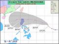
21:00z Track

0 likes
Visit the Caribbean-Central America Weather Thread where you can find at first post web cams,radars
and observations from Caribbean basin members Click Here
and observations from Caribbean basin members Click Here
-
dexterlabio
- Category 5
- Posts: 3511
- Joined: Sat Oct 24, 2009 11:50 pm
Re: WPAC: NARI - Typhoon / Santi
Now officially a typhoon. 
TY 1325 (NARI)
Issued at 18:45 UTC, 10 October 2013
<Analyses at 10/18 UTC>
Scale -
Intensity Strong
Center position N15°20'(15.3°)
E125°25'(125.4°)
Direction and speed of movement W 15km/h(7kt)
Central pressure 975hPa
Maximum wind speed near the center 35m/s(65kt)
Maximum wind gust speed 50m/s(95kt)
Area of 50kt winds or more ALL90km(50NM)
Area of 30kt winds or more N330km(180NM)
S280km(150NM)
<Forecast for 11/18 UTC>
Intensity Strong
Center position of probability circle N15°50'(15.8°)
E121°50'(121.8°)
Direction and speed of movement W 15km/h(9kt)
Central pressure 960hPa
Maximum wind speed near the center 40m/s(75kt)
Maximum wind gust speed 55m/s(105kt)
Radius of probability circle 130km(70NM)
Storm warning area ALL260km(140NM)
<Forecast for 12/18 UTC>
Intensity -
Center position of probability circle N15°50'(15.8°)
E117°40'(117.7°)
Direction and speed of movement W 20km/h(10kt)
Central pressure 975hPa
Maximum wind speed near the center 30m/s(60kt)
Maximum wind gust speed 45m/s(85kt)
Radius of probability circle 260km(140NM)
Storm warning area ALL370km(200NM)
<Forecast for 13/18 UTC>
Intensity Strong
Center position of probability circle N15°35'(15.6°)
E113°10'(113.2°)
Direction and speed of movement W 20km/h(10kt)
Central pressure 965hPa
Maximum wind speed near the center 35m/s(70kt)
Maximum wind gust speed 50m/s(100kt)
Radius of probability circle 390km(210NM)
Storm warning area ALL500km(270NM)

Intense deep convection over the CDO right now, can somebody pinpoint where the center really is? This could be like 2009's 'Santi' or Mirinae, a moderate typhoon but without a clear, visible eye...
TY 1325 (NARI)
Issued at 18:45 UTC, 10 October 2013
<Analyses at 10/18 UTC>
Scale -
Intensity Strong
Center position N15°20'(15.3°)
E125°25'(125.4°)
Direction and speed of movement W 15km/h(7kt)
Central pressure 975hPa
Maximum wind speed near the center 35m/s(65kt)
Maximum wind gust speed 50m/s(95kt)
Area of 50kt winds or more ALL90km(50NM)
Area of 30kt winds or more N330km(180NM)
S280km(150NM)
<Forecast for 11/18 UTC>
Intensity Strong
Center position of probability circle N15°50'(15.8°)
E121°50'(121.8°)
Direction and speed of movement W 15km/h(9kt)
Central pressure 960hPa
Maximum wind speed near the center 40m/s(75kt)
Maximum wind gust speed 55m/s(105kt)
Radius of probability circle 130km(70NM)
Storm warning area ALL260km(140NM)
<Forecast for 12/18 UTC>
Intensity -
Center position of probability circle N15°50'(15.8°)
E117°40'(117.7°)
Direction and speed of movement W 20km/h(10kt)
Central pressure 975hPa
Maximum wind speed near the center 30m/s(60kt)
Maximum wind gust speed 45m/s(85kt)
Radius of probability circle 260km(140NM)
Storm warning area ALL370km(200NM)
<Forecast for 13/18 UTC>
Intensity Strong
Center position of probability circle N15°35'(15.6°)
E113°10'(113.2°)
Direction and speed of movement W 20km/h(10kt)
Central pressure 965hPa
Maximum wind speed near the center 35m/s(70kt)
Maximum wind gust speed 50m/s(100kt)
Radius of probability circle 390km(210NM)
Storm warning area ALL500km(270NM)
Intense deep convection over the CDO right now, can somebody pinpoint where the center really is?
0 likes
Personal Forecast Disclaimer:
The posts in this forum are NOT official forecast and should not be used as such. They are just the opinion of the poster and may or may not be backed by sound meteorological data. They are NOT endorsed by any professional institution or storm2k.org. For official information, please refer to the NHC and NWS products.
The posts in this forum are NOT official forecast and should not be used as such. They are just the opinion of the poster and may or may not be backed by sound meteorological data. They are NOT endorsed by any professional institution or storm2k.org. For official information, please refer to the NHC and NWS products.
-
dexterlabio
- Category 5
- Posts: 3511
- Joined: Sat Oct 24, 2009 11:50 pm
Re: WPAC: NARI - Typhoon / Santi
cycloneye wrote:21:00z Track
So JTWC relocated the center further south.
0 likes
Personal Forecast Disclaimer:
The posts in this forum are NOT official forecast and should not be used as such. They are just the opinion of the poster and may or may not be backed by sound meteorological data. They are NOT endorsed by any professional institution or storm2k.org. For official information, please refer to the NHC and NWS products.
The posts in this forum are NOT official forecast and should not be used as such. They are just the opinion of the poster and may or may not be backed by sound meteorological data. They are NOT endorsed by any professional institution or storm2k.org. For official information, please refer to the NHC and NWS products.
-
Filipinas50
- Tropical Depression

- Posts: 77
- Age: 60
- Joined: Tue May 28, 2013 2:07 am
- Location: Planet Earth
Re: WPAC: NARI - Typhoon / Santi
Typhoon Nari's Outer Rainbands Approaching the East Coast of Luzon this Morning as Seen from the Tagaytay Radar ...

0 likes
RETIRED FROM THE 9-5 RAT RACE
-
cycloneye
- Admin
- Posts: 149576
- Age: 69
- Joined: Thu Oct 10, 2002 10:54 am
- Location: San Juan, Puerto Rico
Re: WPAC: NARI - Typhoon / Santi
00z Best Track up to 100kts.
24W NARI 131011 0000 15.7N 124.3E WPAC 100 948
24W NARI 131011 0000 15.7N 124.3E WPAC 100 948
0 likes
Visit the Caribbean-Central America Weather Thread where you can find at first post web cams,radars
and observations from Caribbean basin members Click Here
and observations from Caribbean basin members Click Here
-
oaba09
- S2K Supporter

- Posts: 1496
- Age: 39
- Joined: Thu Oct 01, 2009 10:02 am
- Location: Valenzuela, Philippines
- Contact:
Latest from JMA(70 kts)

TY 1325 (NARI)
Issued at 00:50 UTC, 11 October 2013
<Analyses at 11/00 UTC>
Scale -
Intensity Strong
Center position N15°20'(15.3°)
E124°30'(124.5°)
Direction and speed of movement W 15km/h(7kt)
Central pressure 970hPa
Maximum wind speed near the center 35m/s(70kt)
Maximum wind gust speed 50m/s(100kt)
Area of 50kt winds or more ALL90km(50NM)
Area of 30kt winds or more N330km(180NM)
S280km(150NM)
<Forecast for 12/00 UTC>
Intensity Strong
Center position of probability circle N15°55'(15.9°)
E120°35'(120.6°)
Direction and speed of movement W 15km/h(9kt)
Central pressure 970hPa
Maximum sustained wind speed 35m/s(65kt)
Maximum wind gust speed 50m/s(95kt)
Radius of probability circle 130km(70NM)
Storm warning area ALL260km(140NM)
<Forecast for 13/00 UTC>
Intensity Strong
Center position of probability circle N15°50'(15.8°)
E116°05'(116.1°)
Direction and speed of movement W 20km/h(11kt)
Central pressure 970hPa
Maximum wind speed near the center 35m/s(65kt)
Maximum wind gust speed 50m/s(95kt)
Radius of probability circle 260km(140NM)
Storm warning area ALL370km(200NM)
<Forecast for 14/00 UTC>
Intensity Strong
Center position of probability circle N15°50'(15.8°)
E112°30'(112.5°)
Direction and speed of movement W 15km/h(9kt)
Central pressure 965hPa
Maximum wind speed near the center 35m/s(70kt)
Maximum wind gust speed 50m/s(100kt)
Radius of probability circle 300km(160NM)
Storm warning area ALL410km(220NM)
0 likes
-
hurricanes1234
- Category 5
- Posts: 2908
- Joined: Sat Jul 28, 2012 6:19 pm
- Location: Trinidad and Tobago
Re: WPAC: NARI - Typhoon / Santi
Major typhoon! 
0 likes
PLEASE NOTE: With the exception of information from weather agencies that I may copy and paste here, my posts will NEVER be official, since I am NOT a meteorologist. They are solely my amateur opinion, and may or may not be accurate. Therefore, please DO NOT use them as official details, particularly when making important decisions. Thank you.
-
hurricanes1234
- Category 5
- Posts: 2908
- Joined: Sat Jul 28, 2012 6:19 pm
- Location: Trinidad and Tobago
Re: WPAC: NARI - Typhoon / Santi
This has to be the most active tropical cyclone day in 2013 so far. One upper-end Category 4 cyclone just 2 mph from C5 status, one 115 mph typhoon in the WPAC, and one strengthening TS with 40 knot winds in the WPAC too. Also the first day with two simultaneous tropical cyclones having winds of 111+ mph. Amazing October 10th 2013.
0 likes
PLEASE NOTE: With the exception of information from weather agencies that I may copy and paste here, my posts will NEVER be official, since I am NOT a meteorologist. They are solely my amateur opinion, and may or may not be accurate. Therefore, please DO NOT use them as official details, particularly when making important decisions. Thank you.
-
cycloneye
- Admin
- Posts: 149576
- Age: 69
- Joined: Thu Oct 10, 2002 10:54 am
- Location: San Juan, Puerto Rico
Re: WPAC: NARI - Typhoon / Santi

0 likes
Visit the Caribbean-Central America Weather Thread where you can find at first post web cams,radars
and observations from Caribbean basin members Click Here
and observations from Caribbean basin members Click Here

2013OCT11 023000 5.0 967.7 90.0 5.0 5.0 4.3 MW HOLD OFF OFF -77.10 -78.24
(Looks at least 100 + knots on the image)
Personal Forecast Disclaimer:
The posts in this forum are NOT official forecast and should not be used as such. They are just the opinion of the poster and may or may not be backed by sound meteorological data. They are NOT endorsed by any professional institution or storm2k.org. For official information, please refer to the NHC and NWS products.
0 likes


-
dexterlabio
- Category 5
- Posts: 3511
- Joined: Sat Oct 24, 2009 11:50 pm
Re: WPAC: NARI - Typhoon / Santi
I don't know why PAGASA shifted the forecast track to the north.
0 likes
Personal Forecast Disclaimer:
The posts in this forum are NOT official forecast and should not be used as such. They are just the opinion of the poster and may or may not be backed by sound meteorological data. They are NOT endorsed by any professional institution or storm2k.org. For official information, please refer to the NHC and NWS products.
The posts in this forum are NOT official forecast and should not be used as such. They are just the opinion of the poster and may or may not be backed by sound meteorological data. They are NOT endorsed by any professional institution or storm2k.org. For official information, please refer to the NHC and NWS products.
-
oaba09
- S2K Supporter
- Posts: 1496
- Age: 39
- Joined: Thu Oct 01, 2009 10:02 am
- Location: Valenzuela, Philippines
- Contact:
Re: WPAC: NARI - Typhoon / Santi
dexterlabio wrote:I don't know why PAGASA shifted the forecast track to the north.
Frankly, I'm baffled....I'm just trying not to say too much because I know the forum has a rule against criticizing agencies.....
0 likes
-
euro6208
Re: WPAC: NARI - Typhoon / Santi
amazing...a major typhoon 100 knots headed for landfall...may god bless everyone in the philippines and india...
0 likes
Who is online
Users browsing this forum: No registered users and 49 guests