


Moderator: S2k Moderators
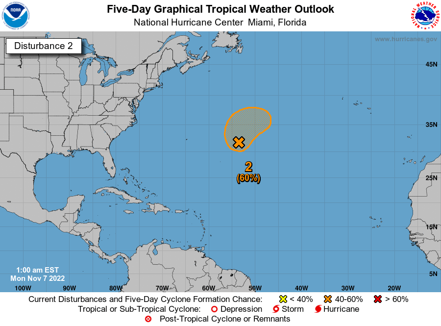
Kazmit_ wrote:Raised to 40%/60% for 8pm. Still has it at 50% for five days for some reason.
http://www.nhc.noaa.gov/xgtwo/two_atl_5d2.png

abajan wrote:Kazmit_ wrote:Raised to 40%/60% for 8pm. Still has it at 50% for five days for some reason.
http://www.nhc.noaa.gov/xgtwo/two_atl_5d2.png
They were probably in the process of updating the info. Incidentally, that image shows the outlook for another system which is yet to emerge from Africa.


Kazmit_ wrote:abajan wrote:Kazmit_ wrote:Raised to 40%/60% for 8pm. Still has it at 50% for five days for some reason.
http://www.nhc.noaa.gov/xgtwo/two_atl_5d2.png
They were probably in the process of updating the info. Incidentally, that image shows the outlook for another system which is yet to emerge from Africa.
Weird. I think I fixed it now.


abajan wrote:Tropical Weather Discussion
NWS National Hurricane Center Miami FL
805 AM EDT WED SEP 14 2016
Tropical Weather Discussion for North America, Central America
Gulf of Mexico, Caribbean Sea, northern sections of South
America, and Atlantic Ocean to the African coast from the
Equator to 32N. The following information is based on satellite
imagery, weather observations, radar and meteorological analysis.
Based on 0600 UTC surface analysis and satellite imagery through
1015 UTC.
...TROPICAL WAVES...
An Atlantic Ocean tropical wave is along 23W/24W from 21N
southward. A 1009 mb low pressure center is along the wave near
16N. Convective precipitation: scattered to numerous strong from
15N to 18N between 23W and 25W, in parts of the Cabo Verde
Islands.
-----------------------------------------------------------------------------
From the image in the 5-day TWO, it seems they expect its forward motion to decelerate. The cone also seems to indicate a possibility of a more westerly movement.
Gustywind wrote:abajan wrote:Tropical Weather Discussion
NWS National Hurricane Center Miami FL
805 AM EDT WED SEP 14 2016
Tropical Weather Discussion for North America, Central America
Gulf of Mexico, Caribbean Sea, northern sections of South
America, and Atlantic Ocean to the African coast from the
Equator to 32N. The following information is based on satellite
imagery, weather observations, radar and meteorological analysis.
Based on 0600 UTC surface analysis and satellite imagery through
1015 UTC.
...TROPICAL WAVES...
An Atlantic Ocean tropical wave is along 23W/24W from 21N
southward. A 1009 mb low pressure center is along the wave near
16N. Convective precipitation: scattered to numerous strong from
15N to 18N between 23W and 25W, in parts of the Cabo Verde
Islands.
-----------------------------------------------------------------------------
From the image in the 5-day TWO, it seems they expect its forward motion to decelerate. The cone also seems to indicate a possibility of a more westerly movement.
Absolutely and curiously NHC TWD do not mention any direction but looks like imo a more westerly track during the next couple of days. We will see.


NHC wrote:...NEW TROPICAL DEPRESSION FORMS OVER THE WESTERN CABO VERDE ISLANDS...
Users browsing this forum: No registered users and 24 guests


