Strong Tropical Wave emerging from West Africa (Is INVEST 90L)
Moderator: S2k Moderators
Forum rules

The posts in this forum are NOT official forecasts and should not be used as such. They are just the opinion of the poster and may or may not be backed by sound meteorological data. They are NOT endorsed by any professional institution or STORM2K. For official information, please refer to products from the National Hurricane Center and National Weather Service.
-
Hurricaneman

- Category 5

- Posts: 7404
- Age: 45
- Joined: Tue Aug 31, 2004 3:24 pm
- Location: central florida
Re: Tropical Wave in West Africa
My personal feeling about this wave is that it will be the first major of the year
0 likes
-
galaxy401

- Category 5
- Posts: 2446
- Age: 30
- Joined: Sat Aug 25, 2012 9:04 pm
- Location: Casa Grande, Arizona
Re: Tropical Wave in West Africa
Tropical Weather Outlook
NWS National Hurricane Center Miami FL
200 AM EDT Wed Aug 29 2018
For the North Atlantic...Caribbean Sea and the Gulf of Mexico:
A tropical wave is forecast to move off the west coast of Africa
late Thursday or early Friday, with an area of low pressure likely
to form between the coast of Africa and the Cabo Verde Islands.
Development of this system is possible over the weekend while it
moves west-northwestward over the eastern tropical Atlantic Ocean.
Development could be limited early next week when the system reaches
cooler waters west of the Cabo Verde Islands.
* Formation chance through 48 hours...low...near 0 percent.
* Formation chance through 5 days...low...30 percent.
$$
Forecaster Berg
0 likes
Got my eyes on moving right into Hurricane Alley: Florida.

Re: Tropical Wave in West Africa
PV Shredder is gone and goes deep headed to the North Pole.
Next wave is the one to watch.
Possible Carib Cruiser

Next wave is the one to watch.
Possible Carib Cruiser
0 likes
-
tolakram
- Admin

- Posts: 20183
- Age: 62
- Joined: Sun Aug 27, 2006 8:23 pm
- Location: Florence, KY (name is Mark)
Re: Tropical Wave in West Africa
This comes close to the Cabo Verde islands but after that looks like a nice slow ACE builder. Hopefully it stays that way.
0 likes
M a r k
- - - - -
Join us in chat: Storm2K Chatroom Invite. Android and IOS apps also available.
The posts in this forum are NOT official forecasts and should not be used as such. Posts are NOT endorsed by any professional institution or STORM2K.org. For official information and forecasts, please refer to NHC and NWS products.
-
cycloneye

- Admin
- Posts: 149342
- Age: 69
- Joined: Thu Oct 10, 2002 10:54 am
- Location: San Juan, Puerto Rico
Re: Tropical Wave in West Africa
Tropical Weather Outlook
NWS National Hurricane Center Miami FL
800 AM EDT Wed Aug 29 2018
For the North Atlantic...Caribbean Sea and the Gulf of Mexico:
A low pressure area is forecast to form between the coast of Africa
and the Cabo Verde Islands in association with a tropical wave that
is expected to move off the west coast of Africa late Thursday or
early Friday. Additional development is anticipated, and a tropical
depression could form over the weekend while the system moves
west-northwestward near the Cabo Verde Islands. Interests in those
islands should monitor the progress of this system.
* Formation chance through 48 hours...low...10 percent.
* Formation chance through 5 days...medium...50 percent.
$$
Forecaster Avila

1 likes
Visit the Caribbean-Central America Weather Thread where you can find at first post web cams,radars
and observations from Caribbean basin members Click Here
and observations from Caribbean basin members Click Here
Re: Tropical Wave in West Africa
Strong convection and LL vort over the water just north of 10N
Wondering if this may decouple.
That is, surface low spins up to the north and goes fish while the wave, to the south, moves low thru the MDR along 10 to 15N.


Wondering if this may decouple.
That is, surface low spins up to the north and goes fish while the wave, to the south, moves low thru the MDR along 10 to 15N.
0 likes
-
tropicwatch

- Category 5
- Posts: 3426
- Age: 62
- Joined: Sat Jun 02, 2007 10:01 am
- Location: Panama City Florida
- Contact:
Re: Tropical Wave in West Africa
Will they wait till it is offshore to make it an invest?
0 likes
Tropicwatch
Agnes 72', Eloise 75, Elena 85', Kate 85', Charley 86', Florence 88', Beryl 94', Dean 95', Erin 95', Opal 95', Earl 98', Georges 98', Ivan 2004', Arlene 2005', Dennis 2005', Ida 2009' Debby 2012' Irma 2017' Michael 2018'
Agnes 72', Eloise 75, Elena 85', Kate 85', Charley 86', Florence 88', Beryl 94', Dean 95', Erin 95', Opal 95', Earl 98', Georges 98', Ivan 2004', Arlene 2005', Dennis 2005', Ida 2009' Debby 2012' Irma 2017' Michael 2018'
-
plasticup
Re: Tropical Wave in West Africa
Models are really bullish on this one, and a strong ridge could keep this riding low from Cape Verde right into the Leeward Islands. The first scary wave of the season.
3 likes
-
CyclonicFury

- Category 5
- Posts: 2032
- Age: 27
- Joined: Sun Jul 02, 2017 12:32 pm
- Location: NC
- Contact:
Re: Tropical Wave in West Africa
Most likely this recurves out to sea given its current predicted track, but it is too soon to rule out anything since it has not even exited Africa yet. Based on the recent GFS and ECMWF, this has potential to be a long track hurricane that racks up quite a bit of ACE.
0 likes
NCSU B.S. in Meteorology Class of 2021. Tropical weather blogger at http://www.cyclonicfury.com. My forecasts and thoughts are NOT official, for official forecasts please consult the National Hurricane Center.

-
plasticup
Re: Tropical Wave in West Africa
CyclonicFury wrote:Most likely this recurves out to sea given its current predicted track
Shout out to Bermuda, the bit of land that gets hit every time an Atlantic storm recurves "out to sea"!
2 likes

Re: Tropical Wave in West Africa
TheStormExpert wrote:Definite
How in the world can you say "definite fish" prior to even seeing a clear MLC or the overall dynamics and structure of what could be a broader gyre to move over water? I'd say the possibilities broadly range from zero development, to slow development (thus further west wave progression), to fairly quick and higher latitude development and potential WNW motion as indicated in the TWO. Another reasonable evolution might be what GCANE suggests (above), of a possible duel genesis hypothesis which is a potentially reasonable outcome as well (above).
2 likes
Andy D
(For official information, please refer to the NHC and NWS products.)
(For official information, please refer to the NHC and NWS products.)
-
plasticup
Re: Tropical Wave in West Africa
TheStormExpert wrote:Definite
You are counting on a strong ridge at 120 hours. The models are not unanimous on this, and at 120 hours there is huge variability anyway. If it misses the 4-5 day trough then it's likely a long-tracker into the Caribbean. A Cat 2 into the Leeward Islands is a very possibility.
0 likes
-
chris_fit

- Category 5
- Posts: 3261
- Age: 43
- Joined: Wed Sep 10, 2003 11:58 pm
- Location: Tampa Bay Area, FL
Re: Tropical Wave in West Africa
plasticup wrote:TheStormExpert wrote:Definite
You are counting on a strong ridge at 120 hours. The models are not unanimous on this, and at 120 hours there is huge variability anyway. If it misses the 4-5 day trough then it's likely a long-tracker into the Caribbean. A Cat 2 into the Leeward Islands is a very possibility.
While 'never say never' this is high unlikely - zero guidance suggests any type of threat those islands right now.
0 likes

Re: Tropical Wave in West Africa
plasticup wrote:CyclonicFury wrote:Most likely this recurves out to sea given its current predicted track
Shout out to Bermuda, the bit of land that gets hit every time an Atlantic storm recurves "out to sea"!
The truth! We always seem to get hit.
Last edited by Kazmit on Wed Aug 29, 2018 11:16 am, edited 1 time in total.
1 likes
Igor 2010, Sandy 2012, Fay 2014, Gonzalo 2014, Joaquin 2015, Nicole 2016, Humberto 2019, Imelda 2025
I am only a tropical weather enthusiast. My predictions are not official and may or may not be backed by sound meteorological data. For official information, please refer to the NHC and NWS products.
I am only a tropical weather enthusiast. My predictions are not official and may or may not be backed by sound meteorological data. For official information, please refer to the NHC and NWS products.

-
plasticup
Re: Tropical Wave in West Africa
chris_fit wrote:plasticup wrote:TheStormExpert wrote:Definite
You are counting on a strong ridge at 120 hours. The models are not unanimous on this, and at 120 hours there is huge variability anyway. If it misses the 4-5 day trough then it's likely a long-tracker into the Caribbean. A Cat 2 into the Leeward Islands is a very possibility.
While 'never say never' this is high unlikely - zero guidance suggests any type of threat those islands right now.
06z GFS shows it developing, starting to recurve, then stalling in front of a strong ridge for 2 days. Eventually a trough comes through to pick it up, but it wouldn't be a big shift for this system to miss that trough (weaker trough, stronger ridge, or just a weaker system) and continue west.
We are talking 240+ hours out, so a small change like that is entirely possible.
0 likes
-
cycloneye
- Admin
- Posts: 149342
- Age: 69
- Joined: Thu Oct 10, 2002 10:54 am
- Location: San Juan, Puerto Rico
Re: Tropical Wave in West Africa
12z GFS is stronger than past runs. Goes to major cane.

0 likes
Visit the Caribbean-Central America Weather Thread where you can find at first post web cams,radars
and observations from Caribbean basin members Click Here
and observations from Caribbean basin members Click Here
-
plasticup
Re: Tropical Wave in West Africa
cycloneye wrote:12z GFS is stronger than past runs. Goes to major cane.
And a much stronger ridge. Doesn't look to be recuriving out to 150 hours. I can't see the model past there yet.
0 likes
-
gatorcane

- S2K Supporter

- Posts: 23708
- Age: 48
- Joined: Sun Mar 13, 2005 3:54 pm
- Location: Boca Raton, FL
Re: Tropical Wave in West Africa
At 192 hours, there is much more ridging over the Northern Atlantic but at that position and strength eventually it should recurve on this run. Question is whether this is the start of a trend?
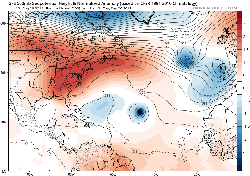
Last edited by gatorcane on Wed Aug 29, 2018 11:32 am, edited 1 time in total.
0 likes
Who is online
Users browsing this forum: No registered users and 103 guests