EPAC: BARBARA - Remnants

Moderator: S2k Moderators

Message
Author
User avatar
Kingarabian
S2K Supporter
S2K Supporter
Posts: 15979
Joined: Sat Aug 08, 2009 3:06 am
Location: Honolulu, Hawaii

Re: EPAC: INVEST 94E

#61 Postby Kingarabian » Sat Jun 29, 2019 9:20 pm

cycloneye wrote:These large monsoon type systems take more time to develop however,once it begins is liftoff to be a strong one but as I post this,it looks very close to TD.Let's see in the next few hours we have a new ASCAT pass and it nails the area and not miss.

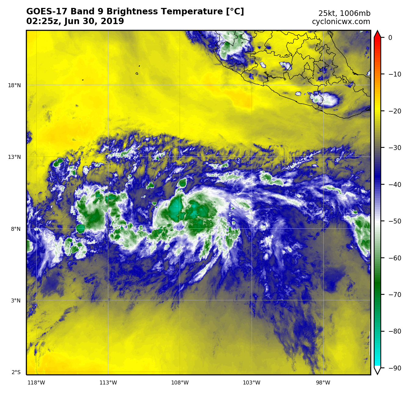
We can see repeated hot towers firing near the COC:
Image

Almost appears that a CDO is forming.
4 likes   
RIP Kobe Bryant

Chris90
Category 2
Category 2
Posts: 646
Age: 35
Joined: Thu Jun 01, 2017 9:36 pm

Re: EPAC: INVEST 94E

#62 Postby Chris90 » Sat Jun 29, 2019 9:40 pm

I'm going to be very surprised if it takes until Monday for this to be designated. It might still be a bit broad and not a perfectly circular LLC, but I think it's deserving. Those hot towers should help improve the circulation further I would think.
0 likes   
Solar Aquarian
Lunar Cancerian
:uarrow: Sagittarian

User avatar
NotSparta
Professional-Met
Professional-Met
Posts: 1668
Age: 23
Joined: Fri Aug 18, 2017 8:24 am
Location: Naples, FL
Contact:

Re: EPAC: INVEST 94E

#63 Postby NotSparta » Sat Jun 29, 2019 9:44 pm

I can already tell where 94E is going to track

Image
4 likes   
This post was probably an opinion of mine, and in no way is official. Please refer to http://www.hurricanes.gov for official tropical analysis and advisories.

My website, with lots of tropical wx graphics, including satellite and recon: http://cyclonicwx.com

User avatar
Kingarabian
S2K Supporter
S2K Supporter
Posts: 15979
Joined: Sat Aug 08, 2009 3:06 am
Location: Honolulu, Hawaii

Re: EPAC: INVEST 94E

#64 Postby Kingarabian » Sat Jun 29, 2019 10:58 pm

00z GFS dropping or showing less influence of a competing vort. Shows more development through 96 hours.
1 likes   
RIP Kobe Bryant

User avatar
cycloneye
Admin
Admin
Posts: 145277
Age: 68
Joined: Thu Oct 10, 2002 10:54 am
Location: San Juan, Puerto Rico

Re: EPAC: INVEST 94E

#65 Postby cycloneye » Sat Jun 29, 2019 11:05 pm

Kingarabian wrote:00z GFS dropping or showing less influence of a competing vort. Shows more development through 96 hours.


Also a little bit stronger than in past runs.
1 likes   
Visit the Caribbean-Central America Weather Thread where you can find at first post web cams,radars
and observations from Caribbean basin members Click Here

User avatar
Kingarabian
S2K Supporter
S2K Supporter
Posts: 15979
Joined: Sat Aug 08, 2009 3:06 am
Location: Honolulu, Hawaii

Re: EPAC: INVEST 94E

#66 Postby Kingarabian » Sat Jun 29, 2019 11:19 pm

cycloneye wrote:
Kingarabian wrote:00z GFS dropping or showing less influence of a competing vort. Shows more development through 96 hours.


Also a little bit stronger than in past runs.


Takes it to a higher latitude sooner than the other models and starts to quickly weaken it past 120 hours.
1 likes   
RIP Kobe Bryant

User avatar
NotSparta
Professional-Met
Professional-Met
Posts: 1668
Age: 23
Joined: Fri Aug 18, 2017 8:24 am
Location: Naples, FL
Contact:

Re: EPAC: INVEST 94E

#67 Postby NotSparta » Sat Jun 29, 2019 11:37 pm

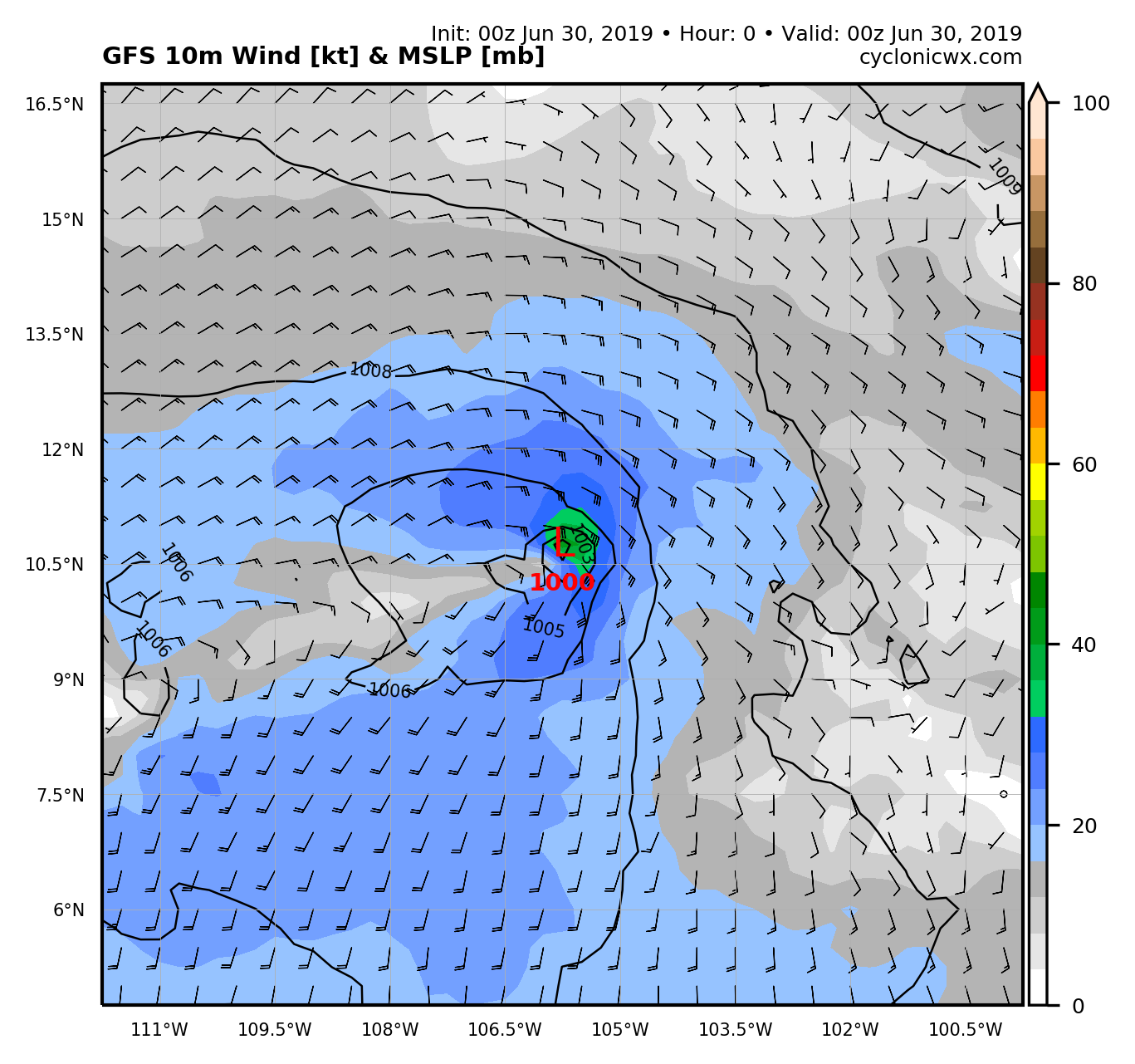
I liked the GFS initialization, seems a bit strong to me but it's hard to know

Image
2 likes   
This post was probably an opinion of mine, and in no way is official. Please refer to http://www.hurricanes.gov for official tropical analysis and advisories.

My website, with lots of tropical wx graphics, including satellite and recon: http://cyclonicwx.com

User avatar
Kingarabian
S2K Supporter
S2K Supporter
Posts: 15979
Joined: Sat Aug 08, 2009 3:06 am
Location: Honolulu, Hawaii

Re: EPAC: INVEST 94E

#68 Postby Kingarabian » Sun Jun 30, 2019 12:27 am

NotSparta wrote:I liked the GFS initialization, seems a bit strong to me but it's hard to know

https://uploads.disquscdn.com/images/fff118666826e521ba54d0fc7a48024b058f114b9ceef0cd37b5db60fdb25769.png

There's a lot of deep convection around the center. It could be a TS at this point. Hard to tell without recon.
1 likes   
RIP Kobe Bryant

User avatar
cycloneye
Admin
Admin
Posts: 145277
Age: 68
Joined: Thu Oct 10, 2002 10:54 am
Location: San Juan, Puerto Rico

Re: EPAC: INVEST 94E

#69 Postby cycloneye » Sun Jun 30, 2019 12:31 am

100%/100%

Showers and thunderstorms associated with a broad area of low
pressure located about 750 miles southwest of the southwestern
coast of Mexico continue to gradually become better organized.
Environmental conditions are conducive for additional development
and a tropical depression or storm is likely to form on Sunday while
the disturbance moves westward to west-northwestward at about
15 mph.
* Formation chance through 48 hours...high...near 100 percent.
* Formation chance through 5 days...high...near 100 percent.
0 likes   
Visit the Caribbean-Central America Weather Thread where you can find at first post web cams,radars
and observations from Caribbean basin members Click Here

Chris90
Category 2
Category 2
Posts: 646
Age: 35
Joined: Thu Jun 01, 2017 9:36 pm

Re: EPAC: INVEST 94E

#70 Postby Chris90 » Sun Jun 30, 2019 12:35 am

NotSparta wrote:I liked the GFS initialization, seems a bit strong to me but it's hard to know

Image


Ok, kind of off topic, but I've never seen model output on your site before, so I just went and checked and don't see anything there. Is that something you're working on that you haven't made available yet, or am I missing out because I always use my phone and it isn't available to me on mobile? I really like that model plot though and want access :D.
0 likes   
Solar Aquarian
Lunar Cancerian
:uarrow: Sagittarian

User avatar
Kingarabian
S2K Supporter
S2K Supporter
Posts: 15979
Joined: Sat Aug 08, 2009 3:06 am
Location: Honolulu, Hawaii

Re: EPAC: INVEST 94E

#71 Postby Kingarabian » Sun Jun 30, 2019 12:36 am

cycloneye wrote:100%/100%

Showers and thunderstorms associated with a broad area of low
pressure located about 750 miles southwest of the southwestern
coast of Mexico continue to gradually become better organized.
Environmental conditions are conducive for additional development
and a tropical depression or storm is likely to form on Sunday while
the disturbance moves westward to west-northwestward at about
15 mph.
* Formation chance through 48 hours...high...near 100 percent.
* Formation chance through 5 days...high...near 100 percent.

If SAB comes in with 2.0. They should classify TD02E by the next advisory.
3 likes   
RIP Kobe Bryant

User avatar
Kingarabian
S2K Supporter
S2K Supporter
Posts: 15979
Joined: Sat Aug 08, 2009 3:06 am
Location: Honolulu, Hawaii

Re: EPAC: INVEST 94E

#72 Postby Kingarabian » Sun Jun 30, 2019 1:46 am

SAB came in with 2 0.

Edit: Best track up to 35kts.
Last edited by Kingarabian on Sun Jun 30, 2019 2:20 am, edited 1 time in total.
1 likes   
RIP Kobe Bryant

User avatar
Kingarabian
S2K Supporter
S2K Supporter
Posts: 15979
Joined: Sat Aug 08, 2009 3:06 am
Location: Honolulu, Hawaii

Re: EPAC: INVEST 94E

#73 Postby Kingarabian » Sun Jun 30, 2019 2:12 am

00z Euro hours 120-240:
Image
0 likes   
RIP Kobe Bryant

Chris90
Category 2
Category 2
Posts: 646
Age: 35
Joined: Thu Jun 01, 2017 9:36 pm

Re: EPAC: INVEST 94E

#74 Postby Chris90 » Sun Jun 30, 2019 2:50 am

Continues to look better. She's been getting her act together nicely the past 24 hours.

Also, can anyone tell me quick how to get a gif from imgur embedded in my post? I'm trying to use the [imgur] [/imgur] tag thing with the url copied in between them and it isn't working. Despite being a millennial, I seem to be unable to conquer this particular additive to my posts. I want to be helpful and add images and microwave passes to the discussion, but I can't seem to conquer this particular posting skill.
0 likes   
Solar Aquarian
Lunar Cancerian
:uarrow: Sagittarian

User avatar
Nancy Smar
Category 5
Category 5
Posts: 1081
Age: 24
Joined: Wed Aug 16, 2017 10:03 pm

Re: EPAC: INVEST 94E

#75 Postby Nancy Smar » Sun Jun 30, 2019 3:35 am

Updated: Recent satellite wind data indicate that the area of low
pressure located several hundred miles southwest of the
southwestern coast of Mexico is producing tropical-storm-force
winds but the system currently lacks a closed surface circulation.

Showers and thunderstorms associated with the system continue to
show signs of organization and conditions appear conducive for the
formation of a tropical storm later today while the disturbance
moves westward to west-northwestward at about 15 mph. For
additional information on this low see High Seas Forecasts
issued by the National Weather Service.
* Formation chance through 48 hours...high...near 100 percent.
* Formation chance through 5 days...high...near 100 percent.

 https://twitter.com/NHC_Pacific/status/1145249676930637826


Last edited by Nancy Smar on Sun Jun 30, 2019 3:46 am, edited 1 time in total.
0 likes   

User avatar
Kingarabian
S2K Supporter
S2K Supporter
Posts: 15979
Joined: Sat Aug 08, 2009 3:06 am
Location: Honolulu, Hawaii

Re: EPAC: INVEST 94E

#76 Postby Kingarabian » Sun Jun 30, 2019 5:11 am

Chris90 wrote:Continues to look better. She's been getting her act together nicely the past 24 hours.

Also, can anyone tell me quick how to get a gif from imgur embedded in my post? I'm trying to use the [url][/url] tag thing with the url copied in between them and it isn't working. Despite being a millennial, I seem to be unable to conquer this particular additive to my posts. I want to be helpful and add images and microwave passes to the discussion, but I can't seem to conquer this particular posting skill.

Make sure you're using the link that's specially for BB/Forums. Imgur has a couple of different linking options when you click on the share button.

Anyways a CDO with very cold tops has pretty much formed over the LLC:
Image
2 likes   
RIP Kobe Bryant

User avatar
NotSparta
Professional-Met
Professional-Met
Posts: 1668
Age: 23
Joined: Fri Aug 18, 2017 8:24 am
Location: Naples, FL
Contact:

Re: EPAC: INVEST 94E

#77 Postby NotSparta » Sun Jun 30, 2019 5:23 am

Chris90 wrote:
NotSparta wrote:I liked the GFS initialization, seems a bit strong to me but it's hard to know

https://uploads.disquscdn.com/images/fff118666826e521ba54d0fc7a48024b058f114b9ceef0cd37b5db60fdb25769.png


Ok, kind of off topic, but I've never seen model output on your site before, so I just went and checked and don't see anything there. Is that something you're working on that you haven't made available yet, or am I missing out because I always use my phone and it isn't available to me on mobile? I really like that model plot though and want access :D.


Yes, not finished yet so it's not available. Sorry. Look for it in July or August
1 likes   
This post was probably an opinion of mine, and in no way is official. Please refer to http://www.hurricanes.gov for official tropical analysis and advisories.

My website, with lots of tropical wx graphics, including satellite and recon: http://cyclonicwx.com

User avatar
cycloneye
Admin
Admin
Posts: 145277
Age: 68
Joined: Thu Oct 10, 2002 10:54 am
Location: San Juan, Puerto Rico

Re: EPAC: INVEST 94E

#78 Postby cycloneye » Sun Jun 30, 2019 6:32 am

First advisory on Tropical Storm Barbara at 8 AM PDT

Satellite imagery is indicating that the area of low pressure
located several hundred miles southwest of the southern coast of
Mexico continues to become better organized, and a tropical storm
may be developing. If this trend continues, advisories may be
initiated later this morning on this system as it moves westward to
west-northwestward at about 15 mph. For additional information on
this low see High Seas Forecasts issued by the National Weather
Service.
* Formation chance through 48 hours...high...near 100 percent.
* Formation chance through 5 days...high...near 100 percent.
1 likes   
Visit the Caribbean-Central America Weather Thread where you can find at first post web cams,radars
and observations from Caribbean basin members Click Here

Shell Mound
Category 5
Category 5
Posts: 2434
Age: 32
Joined: Thu Sep 07, 2017 3:39 pm
Location: St. Petersburg, FL → Scandinavia

Re: EPAC: INVEST 94E-- First advisory on TS Barbara at 8 AM PDT

#79 Postby Shell Mound » Sun Jun 30, 2019 7:04 am

Given the rapid, incipient development of a potentially compact inner core, low latitude, proximity to high PWATs (in the ITCZ), and very low vertical wind shear, BARBARA could well become far stronger than the dynamical models currently indicate. Obviously, SSTs will be more than sufficiently warm, and oceanic heat content sufficiently deep, to allow for steady to significant deepening over the next few days. The farther southwest BARBARA remains in the short term, the more time it will have to consolidate, since it would remain over the warmest water for a prolonged period, avoiding more stable air to the north. If BARBARA continues to organise at its current rate, then a high-end Category-4 hurricane—perhaps 125 to 135 knots—is not out of the question, before cooler SSTs, a more stable air mass, and stronger vertical wind shear set in. Given climatology, regardless of its exact track, BARBARA is unlikely to be a significant event, in terms of impact(s), in the Hawaiian Islands, though it may become quite strong in the short term.
2 likes   
CVW / MiamiensisWx / Shell Mound
The posts in this forum are NOT official forecasts and should not be used as such. They are just the opinion of the poster and may or may not be backed by sound meteorological data. They are NOT endorsed by any professional institution or STORM2K. For official information, please refer to products from the NHC and NWS.

User avatar
cycloneye
Admin
Admin
Posts: 145277
Age: 68
Joined: Thu Oct 10, 2002 10:54 am
Location: San Juan, Puerto Rico

Re: EPAC: INVEST 94E

#80 Postby cycloneye » Sun Jun 30, 2019 7:31 am

TXPZ21 KNES 301219
TCSENP

A. TROPICAL DISTURBANCE (94E)

B. 30/1200Z

C. 10.5N

D. 109.7W

E. THREE/GOES-W

F. T2.0/2.0/D1.0/24HRS

G. IR/EIR/SWIR

H. REMARKS...SHEAR PATTERN CHARACTERIZED BY CIRCULARLY DEFINED CLOUD
LINES WITH THE LLCC LESS THAN 75 NM FROM A LARGE COLD OVERCAST FOR A
DT=2.0. MET=1.0. PT=1.5. FT IS BASED ON DT.

I. ADDL POSITIONS

NIL


...LEE
0 likes   
Visit the Caribbean-Central America Weather Thread where you can find at first post web cams,radars
and observations from Caribbean basin members Click Here


Return to “2019”

Who is online

Users browsing this forum: No registered users and 0 guests