2024 WPAC Season
Moderator: S2k Moderators
Forum rules

The posts in this forum are NOT official forecasts and should not be used as such. They are just the opinion of the poster and may or may not be backed by sound meteorological data. They are NOT endorsed by any professional institution or STORM2K. For official information, please refer to products from the National Hurricane Center and National Weather Service.
-
Kingarabian

- S2K Supporter

- Posts: 16377
- Joined: Sat Aug 08, 2009 3:06 am
- Location: Honolulu, Hawaii
Re: 2024 WPAC Season
GFS wilding out with the MJO fixing to go strong over the WPAC.
0 likes
RIP Kobe Bryant

Re: 2024 WPAC Season
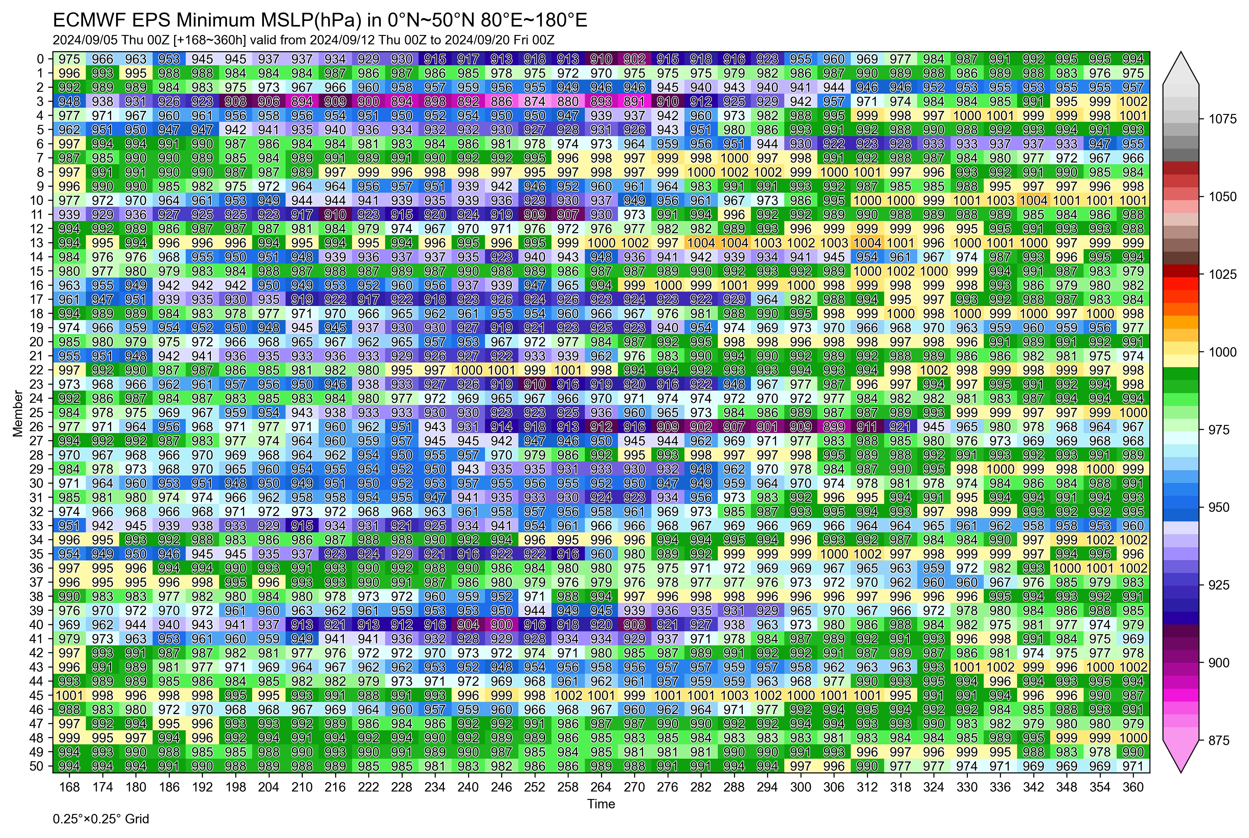
EPS 12Z continues showing sub 900 pressures

0 likes
ヤンデレ女が寝取られるているのを見たい!!!
ECMWF ensemble NWPAC plots: https://ecmwfensnwpac.imgbb.com/
Multimodel NWPAC plots: https://multimodelnwpac.imgbb.com/
GFS Ensemble NWPAC plots (16 & 35 day forecast): https://gefsnwpac.imgbb.com/
Plots updated automatically
ECMWF ensemble NWPAC plots: https://ecmwfensnwpac.imgbb.com/
Multimodel NWPAC plots: https://multimodelnwpac.imgbb.com/
GFS Ensemble NWPAC plots (16 & 35 day forecast): https://gefsnwpac.imgbb.com/
Plots updated automatically
-
mrbagyo

- Category 5

- Posts: 3988
- Age: 33
- Joined: Thu Apr 12, 2012 9:18 am
- Location: 14.13N 120.98E
- Contact:
Re: 2024 WPAC Season
I think we now have the incipient disturbance of our monster model typhoon
1 likes
The posts in this forum are NOT official forecast and should not be used as such. They are just the opinion of the poster and may or may not be backed by sound meteorological data. They are NOT endorsed by any professional institution or storm2k.org. For official information, please refer to RSMC, NHC and NWS products.
Re: 2024 WPAC Season
00Z Euro, EPS, and an 885 mb member...


1 likes
ヤンデレ女が寝取られるているのを見たい!!!
ECMWF ensemble NWPAC plots: https://ecmwfensnwpac.imgbb.com/
Multimodel NWPAC plots: https://multimodelnwpac.imgbb.com/
GFS Ensemble NWPAC plots (16 & 35 day forecast): https://gefsnwpac.imgbb.com/
Plots updated automatically
ECMWF ensemble NWPAC plots: https://ecmwfensnwpac.imgbb.com/
Multimodel NWPAC plots: https://multimodelnwpac.imgbb.com/
GFS Ensemble NWPAC plots (16 & 35 day forecast): https://gefsnwpac.imgbb.com/
Plots updated automatically
-
xtyphooncyclonex

- Category 5
- Posts: 3898
- Age: 24
- Joined: Sat Dec 08, 2012 9:07 am
- Location: Cebu City
- Contact:
Re: 2024 WPAC Season
Haven't seen the ECMWF this bullish this far out in a hot minute

0 likes
REMINDER: My opinions that I, or any other NON Pro-Met in this forum, are unofficial. Please do not take my opinions as an official forecast and warning. I am NOT a meteorologist. Following my forecasts blindly may lead to false alarm, danger and risk if official forecasts from agencies are ignored.
-
doomhaMwx

- Category 5
- Posts: 2493
- Age: 27
- Joined: Tue Apr 18, 2017 4:01 am
- Location: Baguio/Benguet, Philippines
- Contact:
Re: 2024 WPAC Season
Hayabusa wrote:00Z Euro, EPS, and an 885 mb member...
https://i.imgur.com/v0T0cBI.gif
https://i.imgur.com/brb9XfM.png
That 885 mb member peaks at 874 mb 252 hours out. Crazy.
3 likes
-
cycloneye

- Admin

- Posts: 149686
- Age: 69
- Joined: Thu Oct 10, 2002 10:54 am
- Location: San Juan, Puerto Rico
Re: 2024 WPAC Season
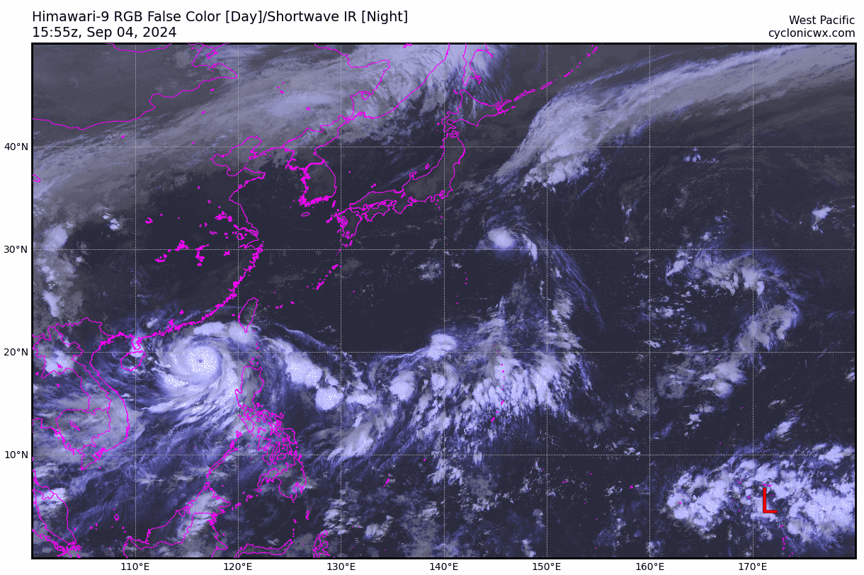
Future 95W taking shape.

0 likes
Visit the Caribbean-Central America Weather Thread where you can find at first post web cams,radars
and observations from Caribbean basin members Click Here
and observations from Caribbean basin members Click Here
-
Kingarabian
- S2K Supporter
- Posts: 16377
- Joined: Sat Aug 08, 2009 3:06 am
- Location: Honolulu, Hawaii
Re: 2024 WPAC Season
Models for a while now have a TC forming northeast of Luzon pretty soon, also they now seem to like developing 91W...
12z


12z
1 likes
ヤンデレ女が寝取られるているのを見たい!!!
ECMWF ensemble NWPAC plots: https://ecmwfensnwpac.imgbb.com/
Multimodel NWPAC plots: https://multimodelnwpac.imgbb.com/
GFS Ensemble NWPAC plots (16 & 35 day forecast): https://gefsnwpac.imgbb.com/
Plots updated automatically
ECMWF ensemble NWPAC plots: https://ecmwfensnwpac.imgbb.com/
Multimodel NWPAC plots: https://multimodelnwpac.imgbb.com/
GFS Ensemble NWPAC plots (16 & 35 day forecast): https://gefsnwpac.imgbb.com/
Plots updated automatically
Re: 2024 WPAC Season
Euro 12z op developing...

Eps 12z, but hinting something developing even before the latest op run

Eps 12z, but hinting something developing even before the latest op run
0 likes
ヤンデレ女が寝取られるているのを見たい!!!
ECMWF ensemble NWPAC plots: https://ecmwfensnwpac.imgbb.com/
Multimodel NWPAC plots: https://multimodelnwpac.imgbb.com/
GFS Ensemble NWPAC plots (16 & 35 day forecast): https://gefsnwpac.imgbb.com/
Plots updated automatically
ECMWF ensemble NWPAC plots: https://ecmwfensnwpac.imgbb.com/
Multimodel NWPAC plots: https://multimodelnwpac.imgbb.com/
GFS Ensemble NWPAC plots (16 & 35 day forecast): https://gefsnwpac.imgbb.com/
Plots updated automatically
Re: 2024 WPAC Season
Looks like the basin will truly wake up again either next week or coming 3rd week
0 likes
ヤンデレ女が寝取られるているのを見たい!!!
ECMWF ensemble NWPAC plots: https://ecmwfensnwpac.imgbb.com/
Multimodel NWPAC plots: https://multimodelnwpac.imgbb.com/
GFS Ensemble NWPAC plots (16 & 35 day forecast): https://gefsnwpac.imgbb.com/
Plots updated automatically
ECMWF ensemble NWPAC plots: https://ecmwfensnwpac.imgbb.com/
Multimodel NWPAC plots: https://multimodelnwpac.imgbb.com/
GFS Ensemble NWPAC plots (16 & 35 day forecast): https://gefsnwpac.imgbb.com/
Plots updated automatically
-
xtyphooncyclonex
- Category 5
- Posts: 3898
- Age: 24
- Joined: Sat Dec 08, 2012 9:07 am
- Location: Cebu City
- Contact:
Re: 2024 WPAC Season
Last time I saw this, there was barely a resurgence. But I'm hoping for some *harmless* action.
Signs do point out lots of activity coming. Let's see...
Unfortunately, cool-neutral to La Niña conditions in the late season don't usually bode well for us in the Philippines (2016, 2020, 2021). So far, we have largely been spared of intense hits a la Rai in most of the islands. Only one was Krathon.
https://x.com/webberweather/status/1846701061253243084
1 likes
REMINDER: My opinions that I, or any other NON Pro-Met in this forum, are unofficial. Please do not take my opinions as an official forecast and warning. I am NOT a meteorologist. Following my forecasts blindly may lead to false alarm, danger and risk if official forecasts from agencies are ignored.
-
xtyphooncyclonex
- Category 5
- Posts: 3898
- Age: 24
- Joined: Sat Dec 08, 2012 9:07 am
- Location: Cebu City
- Contact:
Re: 2024 WPAC Season
GFS and the ECMWF in strikingly good agreement on two powerful typhoons --- one turning west to the PH and the other recurving. Could get a sizable typhoon days, C3 days and ACE boost.
0 likes
REMINDER: My opinions that I, or any other NON Pro-Met in this forum, are unofficial. Please do not take my opinions as an official forecast and warning. I am NOT a meteorologist. Following my forecasts blindly may lead to false alarm, danger and risk if official forecasts from agencies are ignored.
-
Ed_2001

- Tropical Storm

- Posts: 246
- Age: 24
- Joined: Wed Jun 21, 2017 11:39 pm
- Location: Santa Barbara, CA>>Tampa, FL
Re: 2024 WPAC Season
Since Trami fell short of original model predictions due to its huge size and shear, Kong-Rey might become the biggest ACE generator of this (expectedly but once again underwhelming) typhoon season. Current ACE is only 128.6 which is a bit over 50% of average to date. Despite the inactivity we've definitely seen very impactful storms this year. However, 2020-24 will go down as among the least active 5 year periods in terms of ACE since records started in 1950.
According to wikipedia the two previous 5 year nadirs that I noticed were 1973 - 77 (989.8 units, or around 198 units a year) and 2007 - 11 (987.1/197.4 a year). Currently for 2020 - 24 we're at (922.7/184.5). This year would need to generate at least 64.4 more units of ACE (as of 18z 10/25) to avoid breaking a record. Not impossible, but will be difficult. According to Colorado State University's real time ACE tracker, WPAC still has around 53 units of ACE left to generate on average.
Long term activity trends from climate change aside (which still has a lot of uncertainty and competing factors), I do have a feeling that the next few years will be more active again.
Last edited by Ed_2001 on Sat Oct 26, 2024 12:23 am, edited 1 time in total.
1 likes
The answer my friend, is blowing in the wind...
-
dexterlabio
- Category 5
- Posts: 3517
- Joined: Sat Oct 24, 2009 11:50 pm
Re: 2024 WPAC Season
^ -PDO -ENSO combo really holding back the Pacific
0 likes
Personal Forecast Disclaimer:
The posts in this forum are NOT official forecast and should not be used as such. They are just the opinion of the poster and may or may not be backed by sound meteorological data. They are NOT endorsed by any professional institution or storm2k.org. For official information, please refer to the NHC and NWS products.
The posts in this forum are NOT official forecast and should not be used as such. They are just the opinion of the poster and may or may not be backed by sound meteorological data. They are NOT endorsed by any professional institution or storm2k.org. For official information, please refer to the NHC and NWS products.
-
Ed_2001
- Tropical Storm
- Posts: 246
- Age: 24
- Joined: Wed Jun 21, 2017 11:39 pm
- Location: Santa Barbara, CA>>Tampa, FL
Re: 2024 WPAC Season
dexterlabio wrote:^ -PDO -ENSO combo really holding back the Pacific
The fact that 4 out of the last 5 seasons were -ENSO and the one strong +ENSO year significantly underproduced in number (even though the quality of storms that year were definitely pretty typical for a strong +ENSO), and I don't think the PDO rose to positive even once during this period.
0 likes
The answer my friend, is blowing in the wind...
-
dexterlabio
- Category 5
- Posts: 3517
- Joined: Sat Oct 24, 2009 11:50 pm
Re: 2024 WPAC Season
Ed_2001 wrote:dexterlabio wrote:^ -PDO -ENSO combo really holding back the Pacific
The fact that 4 out of the last 5 seasons were -ENSO and the one strong +ENSO year significantly underproduced in number (even though the quality of storms that year were definitely pretty typical for a strong +ENSO), and I don't think the PDO rose to positive even once during this period.
^Yup, last year despite a pretty potent El Niño it was offset by -PDO to put a cap on the WPAC season. At first I doubted the -PDO influence on TC activity in this basin but looking back, 1972 and 2009 were also pretty strong El Niño years with -PDO...these years featured some classic El Niño howlers but the total number of storms and ACE were underwhelming for an El Niño year.
It would make sense that -PDO -ENSO combo would result to record low Pacific typhoon season. Nonetheless, even in the least active season, you can still get that one (or two) anomaly of an intense TC, like Megi in 2010.
1 likes
Personal Forecast Disclaimer:
The posts in this forum are NOT official forecast and should not be used as such. They are just the opinion of the poster and may or may not be backed by sound meteorological data. They are NOT endorsed by any professional institution or storm2k.org. For official information, please refer to the NHC and NWS products.
The posts in this forum are NOT official forecast and should not be used as such. They are just the opinion of the poster and may or may not be backed by sound meteorological data. They are NOT endorsed by any professional institution or storm2k.org. For official information, please refer to the NHC and NWS products.
-
xtyphooncyclonex
- Category 5
- Posts: 3898
- Age: 24
- Joined: Sat Dec 08, 2012 9:07 am
- Location: Cebu City
- Contact:
Re: 2024 WPAC Season
A season with so many letdowns yet so much catastrophe for Asia --- especially the Philippines, Myanmar, Vietnam, and China. Miss seeing those with lots of long-tracking fish in the sea that live up to model hype and put no one in harm's way. Can't wait for this season to end... so badly.
0 likes
REMINDER: My opinions that I, or any other NON Pro-Met in this forum, are unofficial. Please do not take my opinions as an official forecast and warning. I am NOT a meteorologist. Following my forecasts blindly may lead to false alarm, danger and risk if official forecasts from agencies are ignored.
-
Ed_2001
- Tropical Storm
- Posts: 246
- Age: 24
- Joined: Wed Jun 21, 2017 11:39 pm
- Location: Santa Barbara, CA>>Tampa, FL
Re: 2024 WPAC Season
Ed_2001 wrote:Since Trami fell short of original model predictions due to its huge size and shear, Kong-Rey might become the biggest ACE generator of this (expectedly but once again underwhelming) typhoon season.
I'm unsure about this now that Kong-Rey looks to plow into Taiwan instead of staying for several days offshore.
xtyphooncyclonex wrote:A season with so many letdowns yet so much catastrophe for Asia --- especially the Philippines, Myanmar, Vietnam, and China. Miss seeing those with lots of long-tracking fish in the sea that live up to model hype and put no one in harm's way. Can't wait for this season to end... so badly.
Theme of 2024. Pathetic ACE, but most of the relatively short-lived majors and major to be are big land threats, plus a ton of flooding in general.
Pretty classical La Niña with a touch of AGW signal imo. No storm fully tapped into the MDR region and Philippines sea (yet) but Yagi was among the strongest in the SCS, Ampil was peaking as a C4 almost at Tokyo's latitude and Maria was a well-formed STS going due west into Northern Honshu instead of being an rapidly transitioning system speeding northeast at that latitude.
Has been said before but really dud years like 1973 1998 2010 2020 had at least one storm that fully utilized the Philippine sea. This year has been like 1999 so far but slightly more active.
2 likes
The answer my friend, is blowing in the wind...
Re: 2024 WPAC Season
Yagi or possible Kong-rey could be the strongest this season but seems pretty underwhelming if a typhoon didn't reach at least 155kts in a hot earth with a looming la nina or still neutral...
We still have November and December left but...
We still have November and December left but...
1 likes
ヤンデレ女が寝取られるているのを見たい!!!
ECMWF ensemble NWPAC plots: https://ecmwfensnwpac.imgbb.com/
Multimodel NWPAC plots: https://multimodelnwpac.imgbb.com/
GFS Ensemble NWPAC plots (16 & 35 day forecast): https://gefsnwpac.imgbb.com/
Plots updated automatically
ECMWF ensemble NWPAC plots: https://ecmwfensnwpac.imgbb.com/
Multimodel NWPAC plots: https://multimodelnwpac.imgbb.com/
GFS Ensemble NWPAC plots (16 & 35 day forecast): https://gefsnwpac.imgbb.com/
Plots updated automatically
Who is online
Users browsing this forum: Ulf and 205 guests