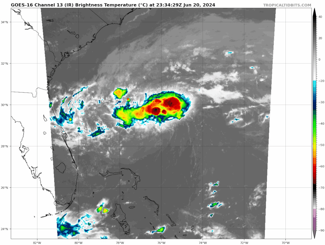
ATL: INVEST 92L - Discussion

Moderator: S2k Moderators

Message
Author
User avatar
skyline385
Category 5
Category 5
Posts: 2728
Age: 34
Joined: Wed Aug 26, 2020 11:15 pm
Location: Houston TX

Re: ATL: INVEST 92L - Discussion

#61 Postby skyline385 » Thu Jun 20, 2024 6:19 pm

Sciencerocks wrote:
NDG wrote:I have seen less organized TDs than this, but I got a feeling as it tracks over the gulf stream in the morning it will tightened up nicely before coming inland. Too bad I have meetings in the morning, I would drive up to NE FL for some little fun with these weak systems.


This is vastly more organized then Alberto was for the first 4 advisories as a pts1 and it isn't even close. This is defined.


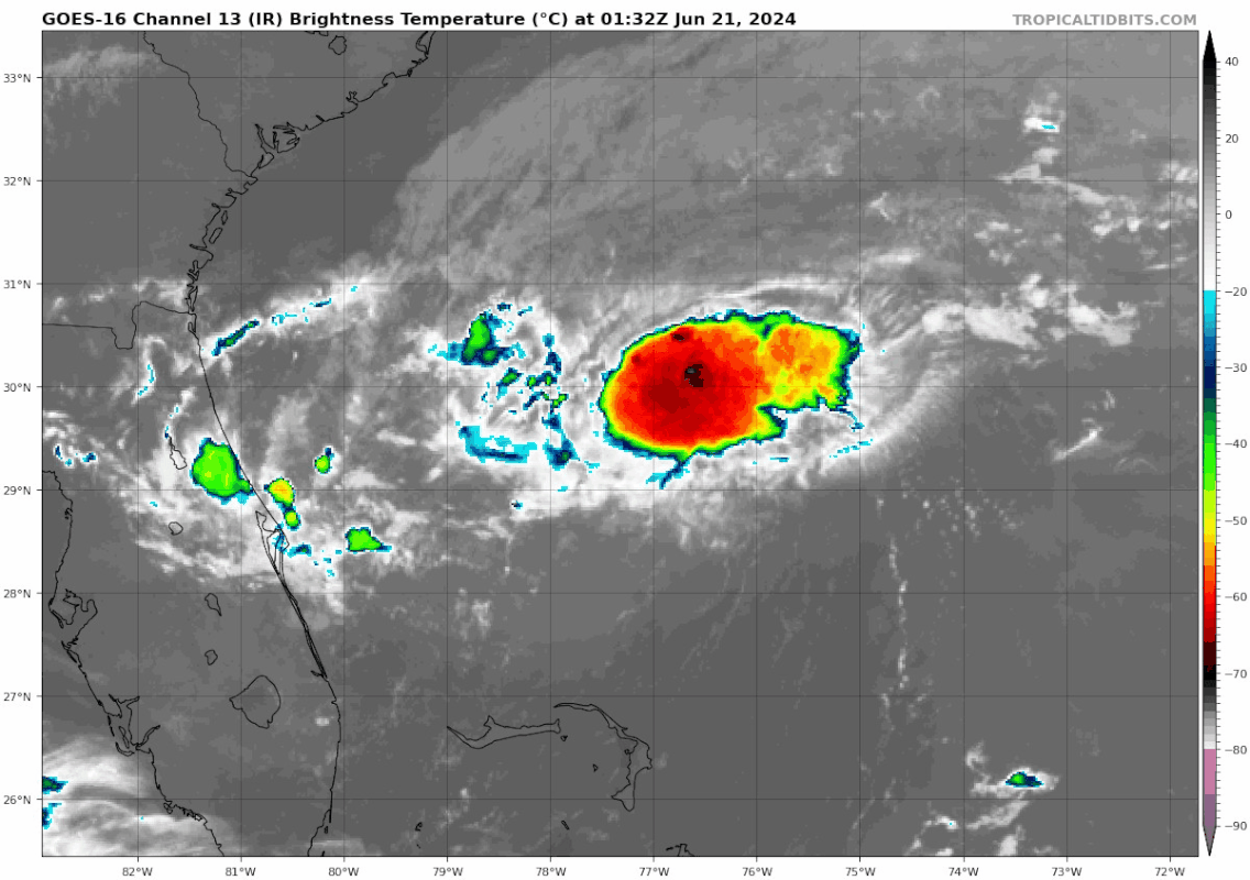
Alberto had complete model and ensemble support, this has no support on the other hand. Recon found a weak circulation in the midst of a relocation which was not well defined and hence they decided to leave it as an invest. It still has a chance at being a TS but it is much less than Alberto and even if it did, it would be a very small & compact TS with limited impacts unlike Alberto which caused coastal flooding along the entire Texas coast and parts of Louisiana, followed by inland flooding from rains in Mexico with 3 fatalities and counting. Alberto's PTC was well deserved simply because of the impacts it would go on to cause.
Last edited by skyline385 on Thu Jun 20, 2024 6:35 pm, edited 1 time in total.
2 likes   

User avatar
cycloneye
Admin
Admin
Posts: 143867
Age: 68
Joined: Thu Oct 10, 2002 10:54 am
Location: San Juan, Puerto Rico

Re: ATL: INVEST 92L - Discussion

#62 Postby cycloneye » Thu Jun 20, 2024 6:26 pm

Southwestern Atlantic Ocean (AL92):
Satellite imagery shows that shower activity associated with the
area of low pressure located about 175 miles north-northeast of the
northern Bahamas has become a little better organized during the
past 24 hours. However, earlier Air Force Reserve Hurricane Hunter
aircraft data indicated that the system does not have a well-defined
circulation. Environmental conditions remain marginally conducive
for additional development and this system could become a tropical
depression while the low moves west-northwestward at 10 to 15 mph.
The system is expected to approach the northeastern coast of Florida
or the Georgia coast early on Friday, and interests there should
monitor the progress of the system. Another Air Force Reserve
aircraft is scheduled to investigate the system on Friday morning,
if necessary.
* Formation chance through 48 hours...medium...50 percent.
* Formation chance through 7 days...medium...50 percent.
0 likes   
Visit the Caribbean-Central America Weather Thread where you can find at first post web cams,radars
and observations from Caribbean basin members Click Here

User avatar
skyline385
Category 5
Category 5
Posts: 2728
Age: 34
Joined: Wed Aug 26, 2020 11:15 pm
Location: Houston TX

Re: ATL: INVEST 92L - Discussion

#63 Postby skyline385 » Thu Jun 20, 2024 7:38 pm

92L decided to explode right at DMIN

Image
0 likes   

User avatar
cycloneye
Admin
Admin
Posts: 143867
Age: 68
Joined: Thu Oct 10, 2002 10:54 am
Location: San Juan, Puerto Rico

Re: ATL: INVEST 92L - Discussion

#64 Postby cycloneye » Thu Jun 20, 2024 7:49 pm

AL, 92, 2024062100, , BEST, 0, 290N, 768W, 30, 1014, DB
1 likes   
Visit the Caribbean-Central America Weather Thread where you can find at first post web cams,radars
and observations from Caribbean basin members Click Here

LarryWx
Category 5
Category 5
Posts: 6246
Joined: Sun Sep 07, 2003 2:04 pm
Location: GA

Re: ATL: INVEST 92L - Discussion

#65 Postby LarryWx » Thu Jun 20, 2024 8:04 pm

skyline385 wrote:92L decided to explode right at DMIN

[url]https://i.postimg.cc/cHP1bDDf/goes16-ir-meso1-2.gif [/url]


Besides being just after DMIN, it is headed toward significantly warmer SSTs in the Gulf Stream. SSTs where it is now (near 29N, 77W) are only ~81 F, but they rise to a peak of ~84 F in the Gulf Stream.
0 likes   
Personal Forecast Disclaimer:
The posts in this forum are NOT official forecasts and should not be used as such. They are just the opinion of the poster and may or may not be backed by sound meteorological data. They are NOT endorsed by any professional institution or storm2k.org. For official information, please refer to the NHC and NWS products.

User avatar
Category5Kaiju
Category 5
Category 5
Posts: 4051
Joined: Thu Dec 24, 2020 12:45 pm
Location: Seattle

Re: ATL: INVEST 92L - Discussion

#66 Postby Category5Kaiju » Thu Jun 20, 2024 8:27 pm

Deep layer shear map shows that 92L is currently under 5-10 knots, which is considered as "favorable"
1 likes   
Unless explicitly stated, all info in my posts is based on my own opinions and observations. Tropical storms and hurricanes can be extremely dangerous. Do not think you can beat Mother Nature. Refer to an accredited weather research agency or meteorologist if you need to make serious decisions regarding an approaching storm.

User avatar
Hypercane_Kyle
Category 5
Category 5
Posts: 3344
Joined: Sat Mar 07, 2015 7:58 pm
Location: Cape Canaveral, FL

Re: ATL: INVEST 92L - Discussion

#67 Postby Hypercane_Kyle » Thu Jun 20, 2024 9:01 pm

Kind of reminds me of Danny in 2021, similar genesis and time of year. I'd say the odds of TC genesis are much higher; closer to 70%.
2 likes   
My posts are my own personal opinion, defer to the National Hurricane Center (NHC) and other NOAA products for decision making during hurricane season.

LarryWx
Category 5
Category 5
Posts: 6246
Joined: Sun Sep 07, 2003 2:04 pm
Location: GA

Re: ATL: INVEST 92L - Discussion

#68 Postby LarryWx » Thu Jun 20, 2024 9:37 pm

The 18Z GFS progged IR satellite view for 9PM EDT isn’t anywhere close to the actual 9PM IR image!
0 likes   
Personal Forecast Disclaimer:
The posts in this forum are NOT official forecasts and should not be used as such. They are just the opinion of the poster and may or may not be backed by sound meteorological data. They are NOT endorsed by any professional institution or storm2k.org. For official information, please refer to the NHC and NWS products.

User avatar
cycloneye
Admin
Admin
Posts: 143867
Age: 68
Joined: Thu Oct 10, 2002 10:54 am
Location: San Juan, Puerto Rico

Re: ATL: INVEST 92L - Discussion

#69 Postby cycloneye » Thu Jun 20, 2024 9:42 pm

1 likes   
Visit the Caribbean-Central America Weather Thread where you can find at first post web cams,radars
and observations from Caribbean basin members Click Here

Sciencerocks
Category 5
Category 5
Posts: 8903
Age: 39
Joined: Thu Jul 06, 2017 1:51 am

Re: ATL: INVEST 92L - Discussion

#70 Postby Sciencerocks » Thu Jun 20, 2024 9:46 pm

Damn it looks good! probably 35 knts and could get up to 45-50 knts by landfall.
Image
2 likes   

LarryWx
Category 5
Category 5
Posts: 6246
Joined: Sun Sep 07, 2003 2:04 pm
Location: GA

Re: ATL: INVEST 92L - Discussion

#71 Postby LarryWx » Thu Jun 20, 2024 9:55 pm

Sciencerocks wrote:Damn it looks good! probably 35 knts and could get up to 45-50 knts by landfall.
https://i.imgur.com/jcgomZv.gif


Is the LLC already at or even slightly N of 30N like your loop at least suggests is quite possible?
0 likes   
Personal Forecast Disclaimer:
The posts in this forum are NOT official forecasts and should not be used as such. They are just the opinion of the poster and may or may not be backed by sound meteorological data. They are NOT endorsed by any professional institution or storm2k.org. For official information, please refer to the NHC and NWS products.

psyclone
S2K Supporter
S2K Supporter
Posts: 4745
Joined: Wed Aug 24, 2005 9:04 pm
Location: palm harbor fl

Re: ATL: INVEST 92L - Discussion

#72 Postby psyclone » Thu Jun 20, 2024 10:07 pm

Looks like a baby TS headed for Brunswick to Savannah.
0 likes   

Sciencerocks
Category 5
Category 5
Posts: 8903
Age: 39
Joined: Thu Jul 06, 2017 1:51 am

Re: ATL: INVEST 92L - Discussion

#73 Postby Sciencerocks » Thu Jun 20, 2024 10:12 pm

LarryWx wrote:
Sciencerocks wrote:Damn it looks good! probably 35 knts and could get up to 45-50 knts by landfall.
https://i.imgur.com/jcgomZv.gif


Is the LLC already at or even slightly N of 30N like your loop at least suggests is quite possible?


Closer to 29.5 north or near the small blow up. Probably some southerly shear blowing the main convection of the LLC.
1 likes   

User avatar
skyline385
Category 5
Category 5
Posts: 2728
Age: 34
Joined: Wed Aug 26, 2020 11:15 pm
Location: Houston TX

Re: ATL: INVEST 92L - Discussion

#74 Postby skyline385 » Thu Jun 20, 2024 11:06 pm

Seems to be trying to develop banding to the south, plus some outflow expansion to the north. Also some very persistent towers in it, wont be surprised if its stronger than expected tomorrow morning.

Image
1 likes   

AxaltaRacing24
Category 5
Category 5
Posts: 1753
Age: 24
Joined: Wed Jul 27, 2016 11:14 am
Location: Jupiter, FL

Re: ATL: INVEST 92L - Discussion

#75 Postby AxaltaRacing24 » Thu Jun 20, 2024 11:22 pm

Starting to look very TDish to me, lets see what recon finds.
0 likes   

LarryWx
Category 5
Category 5
Posts: 6246
Joined: Sun Sep 07, 2003 2:04 pm
Location: GA

Re: ATL: INVEST 92L - Discussion

#76 Postby LarryWx » Thu Jun 20, 2024 11:27 pm

No recon til 8AM EDT?
0 likes   
Personal Forecast Disclaimer:
The posts in this forum are NOT official forecasts and should not be used as such. They are just the opinion of the poster and may or may not be backed by sound meteorological data. They are NOT endorsed by any professional institution or storm2k.org. For official information, please refer to the NHC and NWS products.

User avatar
Beef Stew
Category 1
Category 1
Posts: 495
Joined: Sat May 30, 2020 11:31 am
Location: South Florida

Re: ATL: INVEST 92L - Discussion

#77 Postby Beef Stew » Thu Jun 20, 2024 11:27 pm

This looks like a textbook example of a developing tropical cyclone, that is if it’s not already there. 50% odds is quite low, in my opinion. I’ve certainly seen worse looking systems get tagged as TDs before.
0 likes   

User avatar
skyline385
Category 5
Category 5
Posts: 2728
Age: 34
Joined: Wed Aug 26, 2020 11:15 pm
Location: Houston TX

Re: ATL: INVEST 92L - Discussion

#78 Postby skyline385 » Thu Jun 20, 2024 11:34 pm

LarryWx wrote:No recon til 8AM EDT?


They had recon for 2AM fix but it was pushed to 8AM in interest of flight safety since they didnt find a well defined circulation earlier. Things have changed since then but unfortunately it was already pushed by then.

 https://x.com/JeremyDeHart53d/status/1803987207318855976


 https://x.com/JeremyDeHart53d/status/1803993109887345082


2 likes   

User avatar
JaxGator
Category 2
Category 2
Posts: 780
Joined: Sun Jun 12, 2016 3:33 pm
Location: Jacksonville Florida

Re: ATL: INVEST 92L - Discussion

#79 Postby JaxGator » Thu Jun 20, 2024 11:36 pm

skyline385 wrote:Seems to be trying to develop banding to the south, plus some outflow expansion to the north. Also some very persistent towers in it, wont be surprised if it’s stronger than expected tomorrow morning.


[url]https://i.postimg.cc/tTWTrrS8/goes16-ir-92-L-202406210132.gif [/url]


Definitely getting more organized on IR but it would be nice to have recon there too to confirm more. 92L is also starting to come into radar range. Wonder how similar to 2012’s Beryl if the storm is named besides beneficial rains and dangerous rip currents.
0 likes   
The posts or stuff said are NOT an official forecast. Please look to the NHC and NWS for official forecasts and products.

Floyd-1999, Frances-2004, Jeanne-2004, Fay-2008, Beryl-2012, Debby-2012, Colin-2016, Hermine-2016, Julia-2016, Matthew-2016, Irma-2017, Elsa-2021, Idalia-2023, Debby-2024, Helene-2024.


Go Gators! Go Jags!

LarryWx
Category 5
Category 5
Posts: 6246
Joined: Sun Sep 07, 2003 2:04 pm
Location: GA

Re: ATL: INVEST 92L - Discussion

#80 Postby LarryWx » Thu Jun 20, 2024 11:58 pm

This appears to be the closest buoy to 92L with it at 28.9N, 78.5W or 120 nm E of Cape Canaveral. So, perhaps WSW of 92L’s center: does this tell us anything?

Station 41010
NDBC
Location: 28.878N 78.467W
Date: Fri, 21 Jun 2024 04:30:00 UTC
Winds: ENE (70°) at 3.9 kt gusting to 5.8 kt
Atmospheric Pressure: 30.07 in
Air Temperature: 79.2 F
Dew Point: 75.6 F
Water Temperature: 80.6 F
0 likes   
Personal Forecast Disclaimer:
The posts in this forum are NOT official forecasts and should not be used as such. They are just the opinion of the poster and may or may not be backed by sound meteorological data. They are NOT endorsed by any professional institution or storm2k.org. For official information, please refer to the NHC and NWS products.


Return to “2024”

Who is online

Users browsing this forum: No registered users and 30 guests