Low pressure developing over the western Caribbean Sea (Is Invest 97L)

This is the general tropical discussion area. Anyone can take their shot at predicting a storms path.

Moderator: S2k Moderators

Forum rules

The posts in this forum are NOT official forecasts and should not be used as such. They are just the opinion of the poster and may or may not be backed by sound meteorological data. They are NOT endorsed by any professional institution or STORM2K. For official information, please refer to products from the National Hurricane Center and National Weather Service.

Help Support Storm2K
Message
Author
User avatar
Ivanhater
Storm2k Moderator
Storm2k Moderator
Posts: 11153
Age: 38
Joined: Fri Jul 01, 2005 8:25 am
Location: Pensacola

Re: Area of low pressure to develop over the western Caribbean Sea

#61 Postby Ivanhater » Wed Sep 18, 2024 10:05 am

jfk08c wrote:
Ivanhater wrote:
hurricane2025 wrote:Euro aif has upper Texas coast

Where do you see that. It's getting caught and turned NE well before ever reaching the coast


Newest 06z has landfall around Texas/Louisiana border


Ah, I can only see the 00z. Thanks!
0 likes   
Michael

User avatar
Blown Away
S2K Supporter
S2K Supporter
Posts: 10140
Joined: Wed May 26, 2004 6:17 am

Re: Area of low pressure to develop over the western Caribbean Sea

#62 Postby Blown Away » Wed Sep 18, 2024 10:05 am

jfk08c wrote:
Ivanhater wrote:
hurricane2025 wrote:Euro aif has upper Texas coast

Where do you see that. It's getting caught and turned NE well before ever reaching the coast


Newest 06z has landfall around Texas/Louisiana border

Image
06z... This model has been flopping all over the place since yesterday...
3 likes   
Hurricane Eye Experience: David 79, Irene 99, Frances 04, Jeanne 04, Wilma 05... EYE COMING MY WAY IN 2024…
Hurricane Brush Experience: Andrew 92, Erin 95, Floyd 99, Matthew 16, Irma 17, Ian 22, Nicole 22…

LAF92
Tropical Depression
Tropical Depression
Posts: 51
Joined: Fri Aug 18, 2023 6:27 pm

Re: Area of low pressure to develop over the western Caribbean Sea

#63 Postby LAF92 » Wed Sep 18, 2024 10:07 am

3090 wrote:
Ivanhater wrote:
hurricane2025 wrote:Euro aif has upper Texas coast

Where do you see that. It's getting caught and turned NE well before ever reaching the coast
Please provide the EURO AI image. Earlier I saw it hitting SELA. Thanks!

Image
0 likes   

User avatar
Ivanhater
Storm2k Moderator
Storm2k Moderator
Posts: 11153
Age: 38
Joined: Fri Jul 01, 2005 8:25 am
Location: Pensacola

Re: Area of low pressure to develop over the western Caribbean Sea

#64 Postby Ivanhater » Wed Sep 18, 2024 10:07 am

There definitely has been a west trend today. I think the GFS was developing an eastern vort too quickly but in reality this may be a CAG event over the Yucatan and take longer. Who knows what the 12z suite will show
0 likes   
Michael

MHC Tracking
Tropical Storm
Tropical Storm
Posts: 195
Joined: Mon Mar 15, 2021 10:05 am

Re: Area of low pressure to develop over the western Caribbean Sea

#65 Postby MHC Tracking » Wed Sep 18, 2024 10:08 am

Blown Away wrote:
jfk08c wrote:
Ivanhater wrote:Where do you see that. It's getting caught and turned NE well before ever reaching the coast


Newest 06z has landfall around Texas/Louisiana border

[url]https://i.postimg.cc/65fn62zb/06z-EURO-AI.jpg [/url]
06z... This model has been flopping all over the place since yesterday...

Impressively large hurricane coming in there. Would be a major surge generator
0 likes   

Lightning48
Tropical Low
Tropical Low
Posts: 31
Joined: Mon Mar 07, 2022 12:06 pm

Re: Area of low pressure to develop over the western Caribbean Sea

#66 Postby Lightning48 » Wed Sep 18, 2024 10:11 am

postby wxman57 » Wed Sep 18, 2024 8:04 am

Stormlover70 wrote:
wxman57 wrote:
It appears that we will need to initiate advisories Sunday afternoon. Development in NW Caribbean on Tuesday. Most likely track between central LA and Ft. Myers, FL. Big Bend of FL figures prominently again. Tampa keeps dodging bullets. It's as vulnerable to storm surge as SE LA and MS, with a shoaling factor surge multiplier of about 1.8. I'd say that development chances by next Wednesday are in the 90%+ range. NHC will be steadily increasing development chances to above 60% by Friday.

Main question is whether it will be Helene of Isaac. The remnants of Gordon mess will be absorbed by the frontal low to its north. Some of Gordon's energy will be there, but that low has been looking more impressive than Gordon for 2-3 days. That could become Helene. Gordon won't redevelop. If it's Isaac, watch out! Those "I" storms can be bad, and they hate the Gulf Coast.
I am in pasco count nw of Tampa should I be concerned? Thanks bud.


Your area is definitely at higher risk for landfall. I would be checking to make sure I have all I need in the event of an extended power outage. I think I have about a dozen battery-powered lanterns now and a case of D-cell batteries. Our O2-Cool battery powered fan was a life saver when we were without power after Beryl. Plan for the worst and hope it goes somewhere else.


Wouldn't Tampa have to worry about a storm that landfalls in Pasco as that would be a nightmare coastal and flooding issue?
0 likes   

User avatar
jfk08c
S2K Supporter
S2K Supporter
Posts: 203
Joined: Mon Jun 11, 2018 4:36 pm
Location: Lakeland, FL

Re: Area of low pressure to develop over the western Caribbean Sea

#67 Postby jfk08c » Wed Sep 18, 2024 10:14 am

Image

All models looking pretty spot on for late September/early October climo. I would wager somewhere on the west coast of Florida is the most likely scenario. Once we get a disturbance for models to latch onto, hopefully we will start getting some stronger agreement.
0 likes   

User avatar
Steve
S2K Supporter
S2K Supporter
Posts: 9591
Joined: Sat Apr 05, 2003 11:41 pm
Location: Not a state-caster

Re: Area of low pressure to develop over the western Caribbean Sea

#68 Postby Steve » Wed Sep 18, 2024 10:43 am

I don't see it jkf. Maybe Big Bend? There will be a strong trough cutting across the US but whether that picks this up or not - assuming it develops - remains to be seen. If so, I'd bet you that the Panhandle-Big Bend would be more likely. I realize the Big Bend is kind of technically the W Coast of FL, but I think of that as at least south of Cedar Key.

ICON rolling in and at 174 hours. Looks south of LA Coast and interacting with a EPAC system and also low pressure centered in Illinois. I guess this would get picked up. There are only 6 more hours to the run, so it won't show a landfall. But it looks like it would be somewhere from the mouth of the River over to NWFL.

https://www.tropicaltidbits.com/analysi ... 812&fh=174
1 likes   

User avatar
ScottNAtlanta
Category 5
Category 5
Posts: 2360
Joined: Sat May 25, 2013 3:11 pm
Location: Atlanta, GA

Re: Area of low pressure to develop over the western Caribbean Sea

#69 Postby ScottNAtlanta » Wed Sep 18, 2024 10:48 am

Video for Accuweather


Link: https://youtube.com/watch?v=4wqkaukaDwk
0 likes   
The posts in this forum are NOT official forecast and should not be used as such. They are just the opinion of the poster and may or may not be backed by sound meteorological data. They are NOT endorsed by any professional institution or storm2k.org. For official information, please refer to the NHC and NWS products.

User avatar
jfk08c
S2K Supporter
S2K Supporter
Posts: 203
Joined: Mon Jun 11, 2018 4:36 pm
Location: Lakeland, FL

Re: Area of low pressure to develop over the western Caribbean Sea

#70 Postby jfk08c » Wed Sep 18, 2024 10:49 am

Steve wrote:I don't see it jkf. Maybe Big Bend? There will be a strong trough cutting across the US but whether that picks this up or not - assuming it develops - remains to be seen. If so, I'd bet you that the Panhandle-Big Bend would be more likely. I realize the Big Bend is kind of technically the W Coast of FL, but I think of that as at least south of Cedar Key.

ICON rolling in and at 174 hours. Looks south of LA Coast and interacting with a EPAC system and also low pressure centered in Illinois. I guess this would get picked up. There are only 6 more hours to the run, so it won't show a landfall. But it looks like it would be somewhere from the mouth of the River over to NWFL.

https://www.tropicaltidbits.com/analysi ... 812&fh=174


This one's really tough to predict especially with nothing formed yet. Way too many variables at play with trough timing, location of disturbance formation. I agree models have been trending west lately but I've seen them flip back the other way all too often. Hopefully by this weekend we will actually have a disturbance that is trackable to take out some of the guessing
3 likes   

GalvestonDuck
Category 5
Category 5
Posts: 15941
Age: 57
Joined: Fri Oct 11, 2002 8:11 am
Location: Galveston, oh Galveston (And yeah, it's a barrier island. Wanna make something of it?)

Re: Area of low pressure to develop over the western Caribbean Sea

#71 Postby GalvestonDuck » Wed Sep 18, 2024 10:56 am

wxman57 wrote:Main question is whether it will be Helene of Isaac. The remnants of Gordon mess will be absorbed by the frontal low to its north. Some of Gordon's energy will be there, but that low has been looking more impressive than Gordon for 2-3 days. That could become Helene. Gordon won't redevelop. If it's Isaac, watch out! Those "I" storms can be bad, and they hate the Gulf Coast.


I refuse to be hit by a storm that shares the name with 1900’s Galveston meteorologist Dr. Isaac Cline.
1 likes   

User avatar
StPeteMike
Category 2
Category 2
Posts: 622
Joined: Thu Jun 07, 2018 11:26 pm

Re: Area of low pressure to develop over the western Caribbean Sea

#72 Postby StPeteMike » Wed Sep 18, 2024 10:57 am

Idalia definitely gave the St. Pete area some bad storm surge flooding and she was only a Cat 3 and over 100 miles away from the Pinellas Coast.

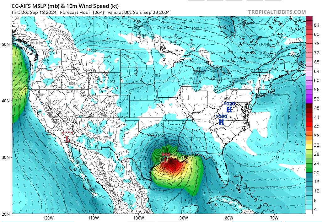
The fear is climatology on this one. Climatology shows that storms this time of year strongly favor more of the east portion of the GOM than the west, though a strong ridge can change that. I just don’t see that strong ridge in the next week or so. If this potential system organizes about 200 hundred miles (closer to Belize City than Cancun), that plenty of time for it to ramp up.

This is all hypothetical until something does start going, of course. But I am with wxman here, think we will see them bump up the chances to 50-60% by Friday.
0 likes   
The above post is not official and should not be used as such. It is the opinion of the poster and may or may not be backed by sound meteorological data. It is not endorsed by any professional institution or storm2k.org. For official information, please refer to the NHC and NWS products.

User avatar
robbielyn
Category 5
Category 5
Posts: 1298
Joined: Wed May 07, 2003 9:45 am
Location: brooksville, fl

Re: Area of low pressure to develop over the western Caribbean Sea

#73 Postby robbielyn » Wed Sep 18, 2024 11:00 am

I do not know whats been making big bend or west coast of fl the target since 2016 with Hermine. Before that it was either sfl or western panhandle. We are oversaturated with rain so we don't even need a depression here. I don't wish for anyone to get hit of course, however, I wish it had a brain to say lets leave the peninsula out this time. After Debby we have had tons of rain since so I really think any tropical storm that comes close to us will cause severe flooding issues. Our river banks are still high.
1 likes   
Robbielyn McCrary
I know just about enough to sound like I know what I'm talking about sometimes. But for your safety please follow the nhc for truly professional forecasting. :D

TomballEd
Category 2
Category 2
Posts: 580
Age: 61
Joined: Wed Aug 16, 2023 4:52 pm
Location: Spring/Klein area, not Tomball

Re: Area of low pressure to develop over the western Caribbean Sea

#74 Postby TomballEd » Wed Sep 18, 2024 11:05 am

Blown Away wrote:
jfk08c wrote:
Ivanhater wrote:Where do you see that. It's getting caught and turned NE well before ever reaching the coast


Newest 06z has landfall around Texas/Louisiana border

[url]https://i.postimg.cc/65fn62zb/06z-EURO-AI.jpg [/url]
06z... This model has been flopping all over the place since yesterday...


That solution becomes less climatologically favored past the Equinox for the NW Gulf. Not impossible, 1949 and 1989 had Texas October hurricanes, but not likely, either. GEFS mean heights would make that unlikely to happen.
0 likes   

User avatar
sunny
Category 5
Category 5
Posts: 7031
Joined: Fri Aug 06, 2004 2:11 pm
Location: New Orleans

Re: Area of low pressure to develop over the western Caribbean Sea

#75 Postby sunny » Wed Sep 18, 2024 11:13 am

TomballEd wrote:
Blown Away wrote:
jfk08c wrote:
Newest 06z has landfall around Texas/Louisiana border

[url]https://i.postimg.cc/65fn62zb/06z-EURO-AI.jpg [/url]
06z... This model has been flopping all over the place since yesterday...


That solution becomes less climatologically favored past the Equinox. Not impossible, 1949 and 1989 had October hurricanes, but not likely, either.


Hurricane Juan in 1985 and Hurricane Zeta 2020. Zeta was a 3. Both around Halloween.
4 likes   

User avatar
StPeteMike
Category 2
Category 2
Posts: 622
Joined: Thu Jun 07, 2018 11:26 pm

Re: Area of low pressure to develop over the western Caribbean Sea

#76 Postby StPeteMike » Wed Sep 18, 2024 11:20 am

Interesting 12z models. Seems like we have two camps, one that gets this organized by Monday and another that takes an extra day for it to get itself together. Icon 12z has gone a little east again too and also gets the system stalled out for a while with the trough coming in.
0 likes   
The above post is not official and should not be used as such. It is the opinion of the poster and may or may not be backed by sound meteorological data. It is not endorsed by any professional institution or storm2k.org. For official information, please refer to the NHC and NWS products.

TomballEd
Category 2
Category 2
Posts: 580
Age: 61
Joined: Wed Aug 16, 2023 4:52 pm
Location: Spring/Klein area, not Tomball

Re: Area of low pressure to develop over the western Caribbean Sea

#77 Postby TomballEd » Wed Sep 18, 2024 11:20 am

sunny wrote:
TomballEd wrote:
Blown Away wrote:[url]https://i.postimg.cc/65fn62zb/06z-EURO-AI.jpg [/url]
06z... This model has been flopping all over the place since yesterday...


That solution becomes less climatologically favored past the Equinox. Not impossible, 1949 and 1989 had October hurricanes, but not likely, either.


Hurricane Juan in 1985 and Hurricane Zeta 2020. Zeta was a 3. Both around Halloween.


Juan sank an oil rig and killed a couple of rig hands. But I'm talking extreme NW Gulf, far W. Louisiana down through Texas.
0 likes   

User avatar
Kazmit
Category 5
Category 5
Posts: 2124
Age: 22
Joined: Mon Jul 25, 2016 8:49 am
Location: Williamsburg, VA / Bermuda

Re: Area of low pressure to develop over the western Caribbean Sea

#78 Postby Kazmit » Wed Sep 18, 2024 11:27 am

With the GFS, the trough keeps sucking it north before it can really get going. Seems that conditions will be quite favorable if it has the time to take advantage of them though.
0 likes   
Igor 2010, Sandy 2012, Fay 2014, Gonzalo 2014, Joaquin 2015, Nicole 2016, Humberto 2019

I am only a tropical weather enthusiast. My predictions are not official and may or may not be backed by sound meteorological data. For official information, please refer to the NHC and NWS products.

User avatar
Ivanhater
Storm2k Moderator
Storm2k Moderator
Posts: 11153
Age: 38
Joined: Fri Jul 01, 2005 8:25 am
Location: Pensacola

Re: Area of low pressure to develop over the western Caribbean Sea

#79 Postby Ivanhater » Wed Sep 18, 2024 11:33 am

12z Canadian looks rough for Pensacola :double:
0 likes   
Michael

User avatar
Kazmit
Category 5
Category 5
Posts: 2124
Age: 22
Joined: Mon Jul 25, 2016 8:49 am
Location: Williamsburg, VA / Bermuda

Re: Area of low pressure to develop over the western Caribbean Sea

#80 Postby Kazmit » Wed Sep 18, 2024 11:35 am

12z GFS has a ridge blocking the system just as it makes landfall, moving it slowly east across northern Florida. Re-emerges in the Atlantic.
0 likes   
Igor 2010, Sandy 2012, Fay 2014, Gonzalo 2014, Joaquin 2015, Nicole 2016, Humberto 2019

I am only a tropical weather enthusiast. My predictions are not official and may or may not be backed by sound meteorological data. For official information, please refer to the NHC and NWS products.


Return to “Talkin' Tropics”

Who is online

Users browsing this forum: Google [Bot], Ulf and 95 guests