2025 ENSO Updates
Moderator: S2k Moderators
Forum rules

The posts in this forum are NOT official forecasts and should not be used as such. They are just the opinion of the poster and may or may not be backed by sound meteorological data. They are NOT endorsed by any professional institution or STORM2K. For official information, please refer to products from the National Hurricane Center and National Weather Service.


Re: 2025 ENSO Updates
There is a WWB going on near 120W in the Pac EQ Epac.
1 likes
The above post and any post by Ntxw is NOT an official forecast and should not be used as such. It is just the opinion of the poster and may or may not be backed by sound meteorological data. It is NOT endorsed by any professional institution including Storm2k. For official information, please refer to NWS products.
Help support Storm2K!
-
DorkyMcDorkface

- Category 5

- Posts: 1039
- Age: 28
- Joined: Mon Sep 30, 2019 1:32 pm
- Location: Mid-Atlantic
Re: 2025 ENSO Updates
Ntxw wrote:There is a WWB going on near 120W in the Pac EQ Epac.
A strong easterly trade surge in the Equatorial CPAC looks to be manifesting concurrently. We already have somewhat of a Modoki Niña look going on (although current anoms are closer to neutral) so I'd imagine that will be reinforced in the coming weeks.


2 likes
Please note the thoughts expressed by this account are solely those of the user and are from a hobbyist perspective. For more comprehensive analysis, consult an actual professional meteorologist or meteorological agency.
Floyd 1999 | Isabel 2003 | Hanna 2008 | Irene 2011 | Sandy 2012 | Isaias 2020
Re: 2025 ENSO Updates
DorkyMcDorkface wrote:Ntxw wrote:There is a WWB going on near 120W in the Pac EQ Epac.
A strong easterly trade surge in the Equatorial CPAC looks to be manifesting concurrently. We already have somewhat of a Modoki Niña look going on (although current anoms are closer to neutral) so I'd imagine that will be reinforced in the coming weeks.
https://i.ibb.co/TMbvNRWS/20250220232735-04d7bc16c3d6fb3a9aa1eef91d273d86b75dff49.png
https://i.ibb.co/HLPyB6QS/eps-u850-anom-hov-equatorial-2025022100.png
https://i.ibb.co/fV7SPJvc/crw-ssta-enso.png
It's normal for weakening cold ENSO to shift EWBs to the IDL and then further west, progression. What's happening in the EQ Epac isn't, is why 1+2 has warmed so much, these epac wwbs since November have reflected some over the PDO each time/PNA.
0 likes
The above post and any post by Ntxw is NOT an official forecast and should not be used as such. It is just the opinion of the poster and may or may not be backed by sound meteorological data. It is NOT endorsed by any professional institution including Storm2k. For official information, please refer to NWS products.
Help support Storm2K!
Help support Storm2K!
-
Kingarabian

- S2K Supporter

- Posts: 16377
- Joined: Sat Aug 08, 2009 3:06 am
- Location: Honolulu, Hawaii
Re: 2025 ENSO Updates
Ntxw wrote:DorkyMcDorkface wrote:Ntxw wrote:There is a WWB going on near 120W in the Pac EQ Epac.
A strong easterly trade surge in the Equatorial CPAC looks to be manifesting concurrently. We already have somewhat of a Modoki Niña look going on (although current anoms are closer to neutral) so I'd imagine that will be reinforced in the coming weeks.
https://i.ibb.co/TMbvNRWS/20250220232735-04d7bc16c3d6fb3a9aa1eef91d273d86b75dff49.png
https://i.ibb.co/HLPyB6QS/eps-u850-anom-hov-equatorial-2025022100.png
https://i.ibb.co/fV7SPJvc/crw-ssta-enso.png
It's normal for weakening cold ENSO to shift EWBs to the IDL and then further west, progression. What's happening in the EQ Epac isn't, is why 1+2 has warmed so much, these epac wwbs since November have reflected some over the PDO each time/PNA.
If memory recalls correct, 2012 and 2017 were good examples on why WWBs in the far eastern Pacific are useless if trades dont slow near the dateline. Without a downwelling KW, WWBs near 120W can cause the Nino regions to warm temporarily only to reverse come July. For warm neutral/El Nino we would need an erupting downwelling KW off of Peru and easterlies between 120W->90W.
1 likes
RIP Kobe Bryant
Re: 2025 ENSO Updates
Kingarabian wrote:Ntxw wrote:DorkyMcDorkface wrote:A strong easterly trade surge in the Equatorial CPAC looks to be manifesting concurrently. We already have somewhat of a Modoki Niña look going on (although current anoms are closer to neutral) so I'd imagine that will be reinforced in the coming weeks.
https://i.ibb.co/TMbvNRWS/20250220232735-04d7bc16c3d6fb3a9aa1eef91d273d86b75dff49.png
https://i.ibb.co/HLPyB6QS/eps-u850-anom-hov-equatorial-2025022100.png
https://i.ibb.co/fV7SPJvc/crw-ssta-enso.png
It's normal for weakening cold ENSO to shift EWBs to the IDL and then further west, progression. What's happening in the EQ Epac isn't, is why 1+2 has warmed so much, these epac wwbs since November have reflected some over the PDO each time/PNA.
If memory recalls correct, 2012 and 2017 were good examples on why WWBs in the far eastern Pacific are useless if trades dont slow near the dateline. Without a downwelling KW, WWBs near 120W can cause the Nino regions to warm temporarily only to reverse come July. For warm neutral/El Nino we would need an erupting downwelling KW off of Peru and easterlies between 120W->90W.
Yeah, to be fair I'm not saying an El Nino initiating wwb is occuring. It's to support the idea of earlier post, there are competing factors against a dominate enso state thus neutral is best bet.
2 likes
The above post and any post by Ntxw is NOT an official forecast and should not be used as such. It is just the opinion of the poster and may or may not be backed by sound meteorological data. It is NOT endorsed by any professional institution including Storm2k. For official information, please refer to NWS products.
Help support Storm2K!
Help support Storm2K!
-
cycloneye

- Admin

- Posts: 149686
- Age: 69
- Joined: Thu Oct 10, 2002 10:54 am
- Location: San Juan, Puerto Rico
Re: 2025 ENSO Updates: CPC 2/24/25 weekly update=Niño Costero 1+2 up to +1.0C / Niño 3.4 at -0.3C
CPC weekly update has niño 1+2 warming up to +1.0C and niño 3.4 remains at -0.3C.
https://www.cpc.ncep.noaa.gov/products/ ... ts-web.pdf

https://www.cpc.ncep.noaa.gov/products/ ... ts-web.pdf
0 likes
Visit the Caribbean-Central America Weather Thread where you can find at first post web cams,radars
and observations from Caribbean basin members Click Here
and observations from Caribbean basin members Click Here
-
cycloneye
- Admin
- Posts: 149686
- Age: 69
- Joined: Thu Oct 10, 2002 10:54 am
- Location: San Juan, Puerto Rico
Re: 2025 ENSO Updates
Text of Andy's message:
While we are still not past the "Spring Predictability Barrier" for ENSO, it looks like we'll go into March with enhanced trades along the dateline for a while. Easterly surges around this time of year tend to be an indicator of ENSO remaining on the cooler side, although it wouldn't surprise me if the far East Pacific "El Niño Costero" persists for another month or two with weaker trades there.
https://x.com/AndyHazelton/status/1894395322392056268
0 likes
Visit the Caribbean-Central America Weather Thread where you can find at first post web cams,radars
and observations from Caribbean basin members Click Here
and observations from Caribbean basin members Click Here
-
weeniepatrol

- Category 5
- Posts: 1345
- Joined: Sat Aug 22, 2020 5:30 pm
- Location: WA State
Re: 2025 ENSO Updates

Despite anemic cool anomalies in Nino 3.4 (ONI will probably only have a single -0.5 trimonthly), the atmosphere response is quite robust. Strong standing wave of suppressed IDL convection.
2 likes
-
cycloneye
- Admin
- Posts: 149686
- Age: 69
- Joined: Thu Oct 10, 2002 10:54 am
- Location: San Juan, Puerto Rico
Re: 2025 ENSO Updates
weeniepatrol wrote:https://i.imgur.com/gNAfze0_d.webp?maxwidth=760&fidelity=grand
Despite anemic cool anomalies in Nino 3.4 (ONI will probably only have a single -0.5 trimonthly), the atmosphere response is quite robust. Strong standing wave of suppressed IDL convection.
And is exactly -0.5C for NDJ.
https://origin.cpc.ncep.noaa.gov/produc ... ONI_v5.php
2 likes
Visit the Caribbean-Central America Weather Thread where you can find at first post web cams,radars
and observations from Caribbean basin members Click Here
and observations from Caribbean basin members Click Here
-
DorkyMcDorkface
- Category 5
- Posts: 1039
- Age: 28
- Joined: Mon Sep 30, 2019 1:32 pm
- Location: Mid-Atlantic
Re: 2025 ENSO Updates
1 likes
Please note the thoughts expressed by this account are solely those of the user and are from a hobbyist perspective. For more comprehensive analysis, consult an actual professional meteorologist or meteorological agency.
Floyd 1999 | Isabel 2003 | Hanna 2008 | Irene 2011 | Sandy 2012 | Isaias 2020
-
Kingarabian
- S2K Supporter
- Posts: 16377
- Joined: Sat Aug 08, 2009 3:06 am
- Location: Honolulu, Hawaii
Re: 2025 ENSO Updates
SPAC is pretty warm as well so its helping to give the look that +ENSO is developing. But the subsurface is the opposite. When Nino 3 and Nino 1+2 warm independently, it's always interesting. But in the grand scheme of the ENSO mechanism, it means nothing. +ENSO doesn't form east to west at the subsurface, rather west to east.
5 likes
RIP Kobe Bryant
-
Hurricane2022

- Category 5
- Posts: 2090
- Joined: Tue Aug 23, 2022 11:38 pm
- Location: Araçatuba, Brazil
Re: 2025 ENSO Updates
0 likes
Sorry for the bad English sometimes...!
For reliable and detailed information for any meteorological phenomenon, please consult the National Hurricane Center, Joint Typhoon Warning Center , or your local Meteo Center.
--------
ECCE OMNIA NOVA FACIAM (Ap 21,5).
For reliable and detailed information for any meteorological phenomenon, please consult the National Hurricane Center, Joint Typhoon Warning Center , or your local Meteo Center.
--------
ECCE OMNIA NOVA FACIAM (Ap 21,5).
-
cycloneye
- Admin
- Posts: 149686
- Age: 69
- Joined: Thu Oct 10, 2002 10:54 am
- Location: San Juan, Puerto Rico
Re: 2025 ENSO Updates=CPC weekly update of 3/3/25=Niño 1+2 at +1.1C / Niño 3.4 at -0.2C
The CPC weekly update of 3/3/25 has niño costero up to +1.1C while Niño 3.4 is at -0.2C.
https://www.cpc.ncep.noaa.gov/products/ ... ts-web.pdf

https://www.cpc.ncep.noaa.gov/products/ ... ts-web.pdf
1 likes
Visit the Caribbean-Central America Weather Thread where you can find at first post web cams,radars
and observations from Caribbean basin members Click Here
and observations from Caribbean basin members Click Here
-
Kingarabian
- S2K Supporter
- Posts: 16377
- Joined: Sat Aug 08, 2009 3:06 am
- Location: Honolulu, Hawaii
Re: 2025 ENSO Updates
Looking more and more likely that the CFS +ENSO forecast will bust for ASO. Nina forcing will get stronger with westerly wind anomalies over the IO and very strong trades continue over the date line. This looks to continue during the first week of April. We haven't even gotten a WPAC WWB yet much less a dateline event.
Doesn't take much to get La Nina/-ENSO. But it takes a lot to get +ENSO/El Nino.
Doesn't take much to get La Nina/-ENSO. But it takes a lot to get +ENSO/El Nino.
2 likes
RIP Kobe Bryant
-
Iceresistance

- Category 5
- Posts: 9605
- Age: 22
- Joined: Sat Oct 10, 2020 9:45 am
- Location: Tecumseh, OK/Norman, OK
Re: 2025 ENSO Updates
What is El Nino costero? I've never heard of that term before
0 likes
Bill 2015 & Beta 2020
Winter 2020-2021
All observations are in Tecumseh, OK unless otherwise noted.
Winter posts are focused mainly for Oklahoma & Texas.
Take any of my forecasts with a grain of salt, refer to the NWS, SPC, and NHC for official information
Never say Never with weather! Because ANYTHING is possible!
Winter 2020-2021
All observations are in Tecumseh, OK unless otherwise noted.
Winter posts are focused mainly for Oklahoma & Texas.
Take any of my forecasts with a grain of salt, refer to the NWS, SPC, and NHC for official information
Never say Never with weather! Because ANYTHING is possible!
-
WeatherBoy2000
- Category 1

- Posts: 463
- Joined: Mon Apr 10, 2023 9:29 am
Re: 2025 ENSO Updates
Iceresistance wrote:
What is El Nino costero? I've never heard of that term before
El nino costero is a term used to describe the el nino like warming of the waters right off South America. It's still not a proper el nino because the nino 3.4 region remains below 0.5c.
1 likes
-
DorkyMcDorkface
- Category 5
- Posts: 1039
- Age: 28
- Joined: Mon Sep 30, 2019 1:32 pm
- Location: Mid-Atlantic
Re: 2025 ENSO Updates
Iceresistance wrote:
What is El Nino costero? I've never heard of that term before
Oh, someone else answered before I could get back to you lol.
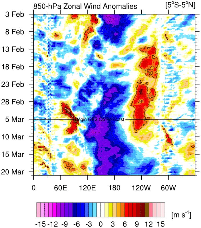
The poster above pretty much explained it. Last time we saw something similar was during the spring of 2017 (albeit 3.4 was warmer than this year). I remember when many agencies were expecting El Niño to emerge from that but it was a "head-fake" in a way as -ENSO ended up developing by the fall due to an unimpressive subsurface and lack of strong WWB activity. Here's a snapshot from late March of that year:

6 likes
Please note the thoughts expressed by this account are solely those of the user and are from a hobbyist perspective. For more comprehensive analysis, consult an actual professional meteorologist or meteorological agency.
Floyd 1999 | Isabel 2003 | Hanna 2008 | Irene 2011 | Sandy 2012 | Isaias 2020
Re: 2025 ENSO Updates
26FEB2025 27.5 1.1 27.0 0.3 26.7-0.2 27.5-0.6
05MAR2025 28.1 1.6 27.4 0.5 27.0 0.0 27.8-0.3
So, the latest week being reported (last calendar week) shows all regions warmed with Nino 3.4 up to 0.0 and Nino 1+2 up to a whopping +1.6. But keep in mind that these aren’t taking into account the relatively warm surrounding tropical/global waters like RONI does. So, one may want to subtract ~0.5 to 0.6 to get a better picture of the situation. Regardless, the trends have been clearly warmer and Nino 1+2, itself, would still be in moderate Nino territory and Nino 3 would be up to neutral.
https://www.cpc.ncep.noaa.gov/data/indi ... st9120.for
0 likes
Personal Forecast Disclaimer:
The posts in this forum are NOT official forecasts and should not be used as such. They are just the opinion of the poster and may or may not be backed by sound meteorological data. They are NOT endorsed by any professional institution or storm2k.org. For official information, please refer to the NHC and NWS products.
The posts in this forum are NOT official forecasts and should not be used as such. They are just the opinion of the poster and may or may not be backed by sound meteorological data. They are NOT endorsed by any professional institution or storm2k.org. For official information, please refer to the NHC and NWS products.
-
cycloneye
- Admin
- Posts: 149686
- Age: 69
- Joined: Thu Oct 10, 2002 10:54 am
- Location: San Juan, Puerto Rico
Re: 2025 ENSO Updates: CPC weekly update of 3/10/25: Niño 1+2 at +1.6C / Niño 3 at +0.5C / Niño 3.4 at 0.0C
The weekly update from CPC has continued warming of the different areas. Niño 1+2 at +1.6C / Niño 3 at +0.5C / Niño 3.4 at 0.0C
https://www.cpc.ncep.noaa.gov/products/ ... ts-web.pdf

https://www.cpc.ncep.noaa.gov/products/ ... ts-web.pdf
0 likes
Visit the Caribbean-Central America Weather Thread where you can find at first post web cams,radars
and observations from Caribbean basin members Click Here
and observations from Caribbean basin members Click Here
Re: 2025 ENSO Updates
LarryWx wrote:26FEB2025 27.5 1.1 27.0 0.3 26.7-0.2 27.5-0.6
05MAR2025 28.1 1.6 27.4 0.5 27.0 0.0 27.8-0.3
So, the latest week being reported (last calendar week) shows all regions warmed with Nino 3.4 up to 0.0 and Nino 1+2 up to a whopping +1.6. But keep in mind that these aren’t taking into account the relatively warm surrounding tropical/global waters like RONI does. So, one may want to subtract ~0.5 to 0.6 to get a better picture of the situation. Regardless, the trends have been clearly warmer and Nino 1+2, itself, would still be in moderate Nino territory and Nino 3 would be up to neutral.
https://www.cpc.ncep.noaa.gov/data/indi ... st9120.for
Question for you Larry, if the RONI is the superior index, how would you grade this past winter noting was showing a better La Nina than ONI based off the PAC teleconnections? My initial guess is that the +PNA and North Pacific Aleutian trough gave some questions as to how reliable it is. Should we not have seen a more robust -PNA/Aleutian ridge combo per RONI?

0 likes
The above post and any post by Ntxw is NOT an official forecast and should not be used as such. It is just the opinion of the poster and may or may not be backed by sound meteorological data. It is NOT endorsed by any professional institution including Storm2k. For official information, please refer to NWS products.
Help support Storm2K!
Help support Storm2K!
Who is online
Users browsing this forum: No registered users and 235 guests