I love it. CMC caves as well to the Euro. Nice corridor of beneficial rainfall from SC TX into North TX (DFW region) setting up within the next 5-10 days as predicted.
Definitely should see the SPC tweak those severe outlooks a little further east for the weekend possibly stretching into next week. A lot to track.
Texas Spring 2026
Moderator: S2k Moderators
Forum rules

The posts in this forum are NOT official forecast and should not be used as such. They are just the opinion of the poster and may or may not be backed by sound meteorological data. They are NOT endorsed by any professional institution or STORM2K.
-
txtwister78

- Category 5

- Posts: 2224
- Joined: Wed Jan 30, 2019 12:56 pm
- Location: San Antonio
Re: Texas Spring 2026
1 likes
-
wxman22

- Category 5
- Posts: 1974
- Joined: Mon Jan 30, 2006 12:39 am
- Location: Wichita Falls, TX
- Contact:
Re: Texas Spring 2026
The SPC is now mentioning the possibility of a substantial severe weather event both Sunday and Tuesday.
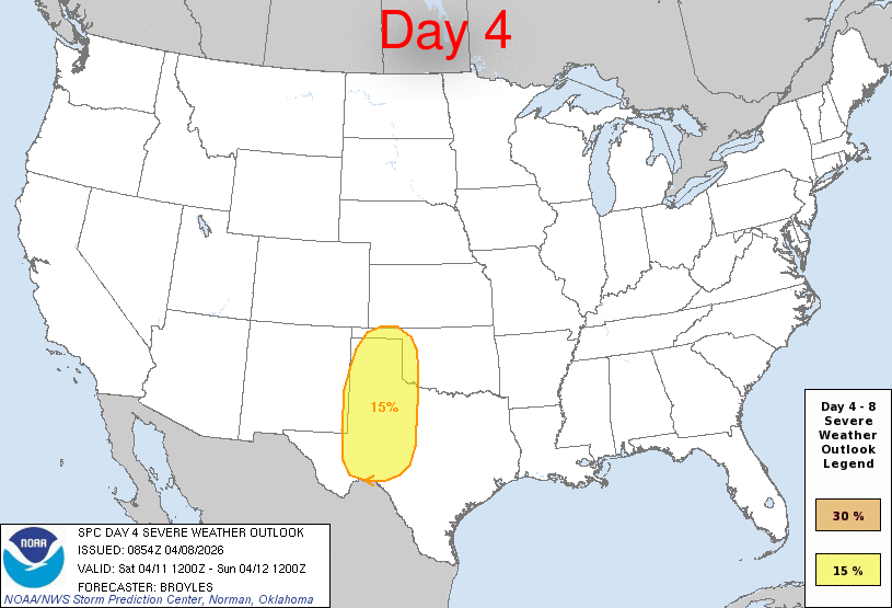
Day 4-8 Convective Outlook
NWS Storm Prediction Center Norman OK
0354 AM CDT Wed Apr 08 2026
Valid 111200Z - 161200Z
...DISCUSSION...
...Saturday/Day 4 to Monday/Day 6...
On Saturday, mid-level southwesterly flow will strengthen over the
central U.S., as an upper-level system moves to near the West Coast.
A moist airmass will be in place over the southern and central
Plains, as a low-amplitude shortwave trough moves across the region.
Large-scale ascent along with warming surface temperatures will
result in scattered thunderstorm development over much of west Texas
Saturday afternoon. MLCAPE is expected to peak near 1000 J/kg in
some areas, with 0-6 km shear being in the 30 to 40 knot range over
much of the southern High Plains. This should be sufficient for a
severe threat, with large hail and severe wind gusts possible.
From Saturday night into Sunday, strong moisture advection is
forecast over the Great Plains. By Sunday afternoon, moderate
instability is expected to be in place over much of this airmass.
Isolated to scattered severe thunderstorms are expected throughout
much of the moist sector during the afternoon and evening. Some
model forecasts move a 50 to 60 knot mid-level jet through central
and northeast Texas during the afternoon and evening. If this
happens, then a substantial severe threat would be possible from
parts of central and north Texas into Oklahoma. Severe storms,
including supercells with large hail, wind damage and a tornado
threat would be possible in areas that destabilize the most.
On Monday, a moist and unstable airmass is forecast to remain from
the southern Plains extending north-northeastward into the Upper
Midwest. Strong to severe thunderstorm development will be possible
over much of the instability corridor in the afternoon and evening.
The greatest potential for severe storms is forecast from the
southern Plains north-northeastward into the lower Missouri Valley
and upper Mississippi Valley, where the models develop moderate
instability and have 0-6 km shear mostly in the 30 to 40 knot range.
Severe storms with large hail, wind damage and a tornado threat will
be possible.
...Tuesday/Day 7 and Wednesday/Day 8...
The western U.S. trough is finally forecast to approach the southern
Plains on Tuesday, where a moist and unstable airmass should be in
place. Some solutions suggest that a mid-level jet will move into
the southern Plains Tuesday afternoon. This would create strong
deep-layer shear over parts of the moist sector, suggesting that a
substantial severe threat will be possible. Although there is still
spatial uncertainty regarding this scenario, current model forecasts
would support supercells with large hail, severe wind gusts and some
tornadoes.
On Wednesday, a shortwave trough is forecast to move through the
central states, with a southwest-to-northeast corridor of moderate
instability in place by afternoon from northeast Texas into western
Ozarks. This would be favorable for severe storms. However, at this
extended range, considerable uncertainty exists concerning severe
threat magnitude and spacing.
..Broyles.. 04/08/2026
0 likes


Re: Texas Spring 2026
Stratton23 wrote:hearing some talk of a “ Super “ El nino event “, ive personally never heard of a Super El nino lol, what would be the difference between a regular el nino and a super one, at least in terms of long term impacts to texas both in the summer and winter?
A Super El Nino is one that reaches +2C above normal in the ENSO 3.4 region for a long period of time. They are the strongest El Ninos and have profound effects years after they terminate, often changing the PDO, creating a new warmer base, and shifting patterns to new regimes. There are only a handful, known is 1877-78, 1982-1983, 1997-1998, and 2015-16. Winters generally are very warm because they flood Canada with warm maritime air more than your typical El Nino but they also feature very strong systems in the winter. They are generally not favorable for cold on a broad scale. However are often associated with periods of very heavy rain throughout the year.
0 likes
The above post and any post by Ntxw is NOT an official forecast and should not be used as such. It is just the opinion of the poster and may or may not be backed by sound meteorological data. It is NOT endorsed by any professional institution including Storm2k. For official information, please refer to NWS products.
Help support Storm2K!
-
TomballEd
- Category 5
- Posts: 1306
- Age: 62
- Joined: Wed Aug 16, 2023 4:52 pm
- Location: Spring/Klein area, not Tomball
Re: Texas Spring 2026
GEFS continue to signal heavy rains for Central Texas and North Texas with less rainfall for STX and SETX. Op Euro from 0Z shows a lot of rain in NETX and SEOK.
0 likes
-
txtwister78
- Category 5
- Posts: 2224
- Joined: Wed Jan 30, 2019 12:56 pm
- Location: San Antonio
Re: Texas Spring 2026
TomballEd wrote:GEFS continue to signal heavy rains for Central Texas and North Texas with less rainfall for STX and SETX. Op Euro from 0Z shows a lot of rain in NETX and SEOK.
Euro Op continues to show SC TX to N TX corridor outside of one run. The ICON and CMC have also trended wetter further south with time. More importantly so have the ensembles.
The GFS continues to be wildly inconsistent. Track record there matters with that model or should.
0 likes
Return to “USA & Caribbean Weather”
Who is online
Users browsing this forum: Iceresistance, TxHunter66 and 177 guests