

ATL GUSTAV: Tropical Depression - Discussion
Moderator: S2k Moderators


Re: ATL: Hurricane Gustav in NW Caribbean Sea
anyone hoping for a stall better also remember it could stall right AFTER landfall...after going through fay I would never wish that on anyone and that was just a trop storm the geography of that coast, that would be bibilical for many areas
0 likes


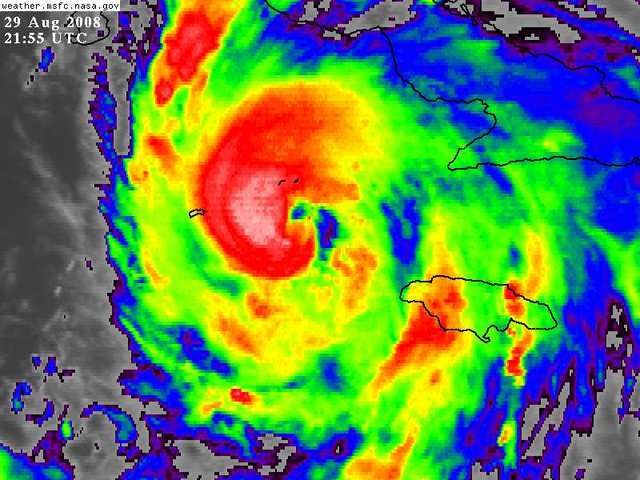
Re: ATL: Hurricane Gustav in Central Caribbean Sea
tolakram wrote:
Interesting view, not sure what the lower cloud levels are.
Dry air getting in?


Beginning to take on the look of a menacing hurricane
0 likes

Re: ATL: Hurricane Gustav in Central Caribbean Sea
Sanibel wrote:One last point - If the trough over the Gulf is upper level you would expect a stronger storm with higher tops to be more influenced by it - right?
Last three center readings:
984
980
977
Hello! Can you say BOOM?
Sanibel, it looks like from the KYW sounding that the GOM trough (ULL?) is at the 200 mb level. Deeper cyclone would be steered more by this layer. But, upper level winds are hostile now in the GOM which means more shear. I also did notice the anticyclone dropping south over Alabama. The models must be anticipating that trough to weaken and migrate west or southwest in response to the high dropping southward in AL. Be interesting with the 00Z models to see what effect (if any) the upper air soundings have on the future track. The data over the water is critical (we have a large data gap in the GOM for upper air).
0 likes
-
Just Joshing You

- Category 2

- Posts: 512
- Joined: Sat Nov 03, 2007 10:29 am
- Location: Nova Scotia
-
nolecaster
- Tropical Depression

- Posts: 52
- Joined: Tue Aug 31, 2004 7:15 pm
- Location: Tallahassee
- Contact:
Re:
Just Joshing You wrote:What is this talk about a 'fist'?
Over the years, posters here have noticed the "fist" right before a hurricane explodes in intensity.
0 likes
Re: ATL: Hurricane Gustav in NW Caribbean Sea
No thread for observations? Caimans are in hurricane conditions right now.....
0 likes
Re: ATL: Hurricane Gustav in Central Caribbean Sea
ronjon wrote:Sanibel wrote:One last point - If the trough over the Gulf is upper level you would expect a stronger storm with higher tops to be more influenced by it - right?
Last three center readings:
984
980
977
Hello! Can you say BOOM?
Sanibel, it looks like from the KYW sounding that the GOM trough (ULL?) is at the 200 mb level. Deeper cyclone would be steered more by this layer. But, upper level winds are hostile now in the GOM which means more shear. I also did notice the anticyclone dropping south over Alabama. The models must be anticipating that trough to weaken and migrate west or southwest in response to the high dropping southward in AL. Be interesting with the 00Z models to see what effect (if any) the upper air soundings have on the future track. The data over the water is critical (we have a large data gap in the GOM for upper air).
ron jon what do you think of the trough like feature over the western bahamas /fla straits , do you see this having any shear or otherwise effects on gustav, mentioned in miami discussion "HAVE NOTICED A
TROUGH OF LOW PRESSURE OVER THE NORTHERN BAHAMAS WHICH MAY
POSSIBLY BE CONNECTED SOMEWHAT TO GUSTAV IS ENHANCING CONVECTION"
0 likes
-
StormWarning1
- Category 1

- Posts: 254
- Joined: Sun Jul 10, 2005 9:29 pm
- Location: Nashville TN
Re: ATL: Hurricane Gustav in Central Caribbean Sea
ronjon wrote:Sanibel wrote:One last point - If the trough over the Gulf is upper level you would expect a stronger storm with higher tops to be more influenced by it - right?
Last three center readings:
984
980
977
Hello! Can you say BOOM?
Sanibel, it looks like from the KYW sounding that the GOM trough (ULL?) is at the 200 mb level. Deeper cyclone would be steered more by this layer. But, upper level winds are hostile now in the GOM which means more shear. I also did notice the anticyclone dropping south over Alabama. The models must be anticipating that trough to weaken and migrate west or southwest in response to the high dropping southward in AL. Be interesting with the 00Z models to see what effect (if any) the upper air soundings have on the future track. The data over the water is critical (we have a large data gap in the GOM for upper air).
Upper air soundings will not be in the 00z GFS run, not enough time to get the data in. Look for it in the 6z model runs.
0 likes
Eye has just taken a little wobble to the north, probably wobbling around quite a lot thanks to the very deep convection blowing up in the eyewall, looking more and more textbook right now, would expect pressure is dropping quite nicely still...also probably has 18-24hrs before any landfall to strengthen.
0 likes

Re: Re:
nolecaster wrote:Just Joshing You wrote:What is this talk about a 'fist'?
Over the years, posters here have noticed the "fist" right before a hurricane explodes in intensity.
As I coined the term, I would say yes. Started at 2115z and wrapped around the center. RI starts in less than 6 hours...count it down...
0 likes
Re: ATL: Hurricane Gustav in Central Caribbean Sea
cpdaman wrote:ronjon wrote:Sanibel wrote:One last point - If the trough over the Gulf is upper level you would expect a stronger storm with higher tops to be more influenced by it - right?
Last three center readings:
984
980
977
Hello! Can you say BOOM?
Sanibel, it looks like from the KYW sounding that the GOM trough (ULL?) is at the 200 mb level. Deeper cyclone would be steered more by this layer. But, upper level winds are hostile now in the GOM which means more shear. I also did notice the anticyclone dropping south over Alabama. The models must be anticipating that trough to weaken and migrate west or southwest in response to the high dropping southward in AL. Be interesting with the 00Z models to see what effect (if any) the upper air soundings have on the future track. The data over the water is critical (we have a large data gap in the GOM for upper air).
ron jon what do you think of the trough like feature over the western bahamas /fla straits , do you see this having any shear or otherwise effects on gustav, mentioned in miami discussion "HAVE NOTICED A
TROUGH OF LOW PRESSURE OVER THE NORTHERN BAHAMAS WHICH MAY
POSSIBLY BE CONNECTED SOMEWHAT TO GUSTAV IS ENHANCING CONVECTION"
cp, that trough is at the surface - it's becoming entrained within the overall circulation of Gus and will likely lead to an increase in TS over S FL tomorrow.
0 likes
Re:
dwg71 wrote:Appears headed right at little caymans, is it supposed to or split with the big island??
There's a forecast point directly on top of the Isle of Yoot (that's how soprano would say it). Gotta be scary for those folks.
And... can anyone recall a 3 day path for a storm from the NHC that's a straight line, like the current one? It's almost like they're saying...okay, I give up, lets pick a path after day 2, then go EXTRAP.
I'm not dissing NHC...it just seems...........irregular.
0 likes
-
Just Joshing You
- Category 2
- Posts: 512
- Joined: Sat Nov 03, 2007 10:29 am
- Location: Nova Scotia
Who is online
Users browsing this forum: No registered users and 24 guests