
With the majority of the storm over for Texas here are some official stats. Sleet is officially counted in the snow category.
CLL: Data is missing for snowfall but it's likely trace
Total QPF: 0.05 inches
IAH (Houston Bush)
Yesterday's snowfall: Trace
Today's snowfall: Trace (likely a record)
Total QPF: 0.05 inches (yesterday and today)
Austin
Yesterday's snowfall: Trace
Today's snowfall: Trace, record is 0.31 (2001)
Total QPF: 0.05 inches (yesterday and today)
So overall the dry runs verified well as stats are kept
Texas Winter 2013-2014
Moderator: S2k Moderators
Forum rules
 The posts in this forum are NOT official forecast and should not be used as such. They are just the opinion of the poster and may or may not be backed by sound meteorological data. They are NOT endorsed by any professional institution or STORM2K.

The posts in this forum are NOT official forecast and should not be used as such. They are just the opinion of the poster and may or may not be backed by sound meteorological data. They are NOT endorsed by any professional institution or STORM2K.
0 likes
The above post and any post by Ntxw is NOT an official forecast and should not be used as such. It is just the opinion of the poster and may or may not be backed by sound meteorological data. It is NOT endorsed by any professional institution including Storm2k. For official information, please refer to NWS products.
Help support Storm2K!
-
TheProfessor

- Professional-Met

- Posts: 3506
- Age: 29
- Joined: Tue Dec 03, 2013 10:56 am
- Location: Wichita, Kansas
Re: Texas Winter 2013-2014
gboudx wrote::uarrow: 57 was referring to you misspelling "players" as "pliers". Hence the "hand tool" comment.
Wow I just now saw that. Thanks
0 likes
An alumnus of The Ohio State University.
Your local National Weather Service office is your best source for weather information.
Your local National Weather Service office is your best source for weather information.


Re: Texas Winter 2013-2014
Not quiet over deep south Texas harlingen is about to get in the action with some sleet and snow we have a winter weather advisory going on
0 likes
 Christopher
Rio Grande Valley Harlingen
Ham Tech Operator: KF5HFA
Re: Texas Winter 2013-2014
As of today the -EPO is approaching -2SD's (daily values) and the WPO has begun it's trek downwards and is well in negative territory. There is a well advertised Aleutian ridge that will park into Alaska. This feature, omega block, will likely send our -EPO into the 3-4 SD's below normal similar to that of early December so expect a similar cold snap to bleed down the rockies next week.
Likewise the PNA is rapidly falling and will approach negative sending the Polar jet down from Canada/Alaska into the southern rockies and southern plains. A couple of big storms will come out of this configuration. There is good tropical connection to the WPAC which leads one to believe some potentially powerful systems to eject out from Texas and either cut into the Lakes or move towards the Apps. +NAO will signal ridging to the east coast thus there will be a battle between cold and warm air to the east of us likely fueling these systems.

Meanwhile the MJO is getting another burst feeding a semi subtropical jet. As I've told gpsnowman this morning, going through analogs and maps of past years one year stuck out. Will we see cold like that? Probably not but it is noteworthy to mention with that incredible warm pool in the NEPAC resembling it so well.


Get your rest the rest of this week, lots of model watching and late night crunching to do. There is nothing wxman57 can do to stop what is coming! No repeat of 1986. I have decided to take control of his weather machine for good, until spring.
Likewise the PNA is rapidly falling and will approach negative sending the Polar jet down from Canada/Alaska into the southern rockies and southern plains. A couple of big storms will come out of this configuration. There is good tropical connection to the WPAC which leads one to believe some potentially powerful systems to eject out from Texas and either cut into the Lakes or move towards the Apps. +NAO will signal ridging to the east coast thus there will be a battle between cold and warm air to the east of us likely fueling these systems.
Meanwhile the MJO is getting another burst feeding a semi subtropical jet. As I've told gpsnowman this morning, going through analogs and maps of past years one year stuck out. Will we see cold like that? Probably not but it is noteworthy to mention with that incredible warm pool in the NEPAC resembling it so well.
Get your rest the rest of this week, lots of model watching and late night crunching to do. There is nothing wxman57 can do to stop what is coming! No repeat of 1986. I have decided to take control of his weather machine for good, until spring.
0 likes
The above post and any post by Ntxw is NOT an official forecast and should not be used as such. It is just the opinion of the poster and may or may not be backed by sound meteorological data. It is NOT endorsed by any professional institution including Storm2k. For official information, please refer to NWS products.
Help support Storm2K!
Help support Storm2K!
-
Rgv20

- S2K Supporter

- Posts: 2466
- Age: 39
- Joined: Wed Jan 05, 2011 5:42 pm
- Location: Edinburg/McAllen Tx
Re: Texas Winter 2013-2014
Ntxw wrote:Meanwhile the MJO is getting another burst feeding a semi subtropical jet. As I've told gpsnowman this morning, going through analogs and maps of past years one year stuck out. Will we see cold like that? Probably not but it is noteworthy to mention with that incredible warm pool in the NEPAC resembling it so well.
What year might that be? 1*99?
P.S: Yes, I intentionally censored the Date!
0 likes
The following post is NOT an official forecast and should not be used as such. It is just the opinion of the poster and may or may not be backed by sound meteorological data. It is NOT endorsed by any professional institution including storm2k.org For Official Information please refer to the NHC and NWS products.
-
WeatherGuesser
- Category 5

- Posts: 2672
- Joined: Tue Jun 29, 2010 6:46 am
Re: Texas Winter 2013-2014
Here is the 18z GFS at 5h for early/mid next week. The OP's all have this big low heights storm, they vary on location run to run and depth of cold air going back and forth. But this is a set up for a blizzard underneath the trowel heading(winds 30-40mph) for negative tilt and likely severe thunderstorms on the other side.

0 likes
The above post and any post by Ntxw is NOT an official forecast and should not be used as such. It is just the opinion of the poster and may or may not be backed by sound meteorological data. It is NOT endorsed by any professional institution including Storm2k. For official information, please refer to NWS products.
Help support Storm2K!
Help support Storm2K!
-
TheProfessor
- Professional-Met
- Posts: 3506
- Age: 29
- Joined: Tue Dec 03, 2013 10:56 am
- Location: Wichita, Kansas
Re:
WeatherGuesser wrote:'learnt' must be Texan for 'learned'.
Actually I looked that up and learnt was the proper way to phrase what I said.
0 likes
An alumnus of The Ohio State University.
Your local National Weather Service office is your best source for weather information.
Your local National Weather Service office is your best source for weather information.
-
Texas Snowman

- Storm2k Moderator

- Posts: 6197
- Joined: Fri Jan 25, 2008 11:29 am
- Location: Denison, Texas
Re: Texas Winter 2013-2014
Ntxw, where is DFW sitting in terms of days with lows at or below freezing?
0 likes
The above post and any post by Texas Snowman is NOT an official forecast and should not be used as such. It is just the opinion of the poster and may or may not be backed by sound meteorological data. It is NOT endorsed by any professional institution including storm2k.org. For official information, please refer to NWS products.
Re: Texas Winter 2013-2014
Texas Snowman wrote:Ntxw, where is DFW sitting in terms of days with lows at or below freezing?
As of today 37, tomorrow will be 38. Then we will need 10 more (I believe we will) to crack 48 and be guaranteed top 10 finish.
0 likes
The above post and any post by Ntxw is NOT an official forecast and should not be used as such. It is just the opinion of the poster and may or may not be backed by sound meteorological data. It is NOT endorsed by any professional institution including Storm2k. For official information, please refer to NWS products.
Help support Storm2K!
Help support Storm2K!
Re: Re:
TheProfessor wrote:WeatherGuesser wrote:'learnt' must be Texan for 'learned'.
Actually I looked that up and learnt was the proper way to phrase what I said.
Very nicely done young man. Refreshing to see young folks actually caring about communication skills. Bravo!
0 likes
I am neither a professional meteorologist nor an amateur meteorologist. Please do not consider any of my posts to be a forecast of anything. Anything I post that is remotely forward looking should be considered speculation at best.
CPC is ramping up for it, look familiar? Remember December?


Speaking of the CPC they predicted a warm FMA for Texas. And now to kick it off they are doing this to February. It's just disgusting and wreckless. We certainly don't pay them to do this after what happened and STILL ongoing. They have countless tools of teleconnections, models, and otherwise yet this???

Speaking of the CPC they predicted a warm FMA for Texas. And now to kick it off they are doing this to February. It's just disgusting and wreckless. We certainly don't pay them to do this after what happened and STILL ongoing. They have countless tools of teleconnections, models, and otherwise yet this???
Last edited by Ntxw on Tue Jan 28, 2014 9:42 pm, edited 1 time in total.
0 likes
The above post and any post by Ntxw is NOT an official forecast and should not be used as such. It is just the opinion of the poster and may or may not be backed by sound meteorological data. It is NOT endorsed by any professional institution including Storm2k. For official information, please refer to NWS products.
Help support Storm2K!
Help support Storm2K!

-
orangeblood
- S2K Supporter
- Posts: 3895
- Joined: Tue Dec 15, 2009 6:14 pm
- Location: Fort Worth, TX
Re:
Ntxw wrote:With the majority of the storm over for Texas here are some official stats. Sleet is officially counted in the snow category.
CLL: Data is missing for snowfall but it's likely trace
Total QPF: 0.05 inches
IAH (Houston Bush)
Yesterday's snowfall: Trace
Today's snowfall: Trace (likely a record)
Total QPF: 0.05 inches (yesterday and today)
Austin
Yesterday's snowfall: Trace
Today's snowfall: Trace, record is 0.31 (2001)
Total QPF: 0.05 inches (yesterday and today)
So overall the dry runs verified well as stats are kept
Good work Ntxw, once again it needs to be noted that the GFS is out performing all models, particularly within the 5 day verification range. NAM has been atrocious!!
0 likes
Re: Re:
orangeblood wrote:Good work Ntxw, once again it needs to be noted that the GFS is out performing all models, particularly within the 5 day verification range. NAM has been atrocious!!
Yes the NAM is having a bad year, although it's doing ok on temperatures just not precip. I heard it was getting an upgrade of some kind soon? Until then we can throw it in the do not trust column with NOAA's monthly and seasonal predictions. We're guaranteed a cold spring at the rate they are going.
Edit: We have to give euro some credit too because it wasn't as wet as the other models for most of it's runs having up to 0.10inches but never going over.
0 likes
The above post and any post by Ntxw is NOT an official forecast and should not be used as such. It is just the opinion of the poster and may or may not be backed by sound meteorological data. It is NOT endorsed by any professional institution including Storm2k. For official information, please refer to NWS products.
Help support Storm2K!
Help support Storm2K!
-
SaskatchewanScreamer
sigh I should have picked this one earlier....

Now I really did expect Tireman4 to upload a picture of one he or his kids made (in fact I would've thought all of you would've made one given your child-like excitement over the thought of snow).
I still can't get over how a little bit of sleet/ice rain/snow can shut your cities down re the power I was referring to earlier (but I have seen enough pics on my FB feed to know why it is done).

Now I really did expect Tireman4 to upload a picture of one he or his kids made (in fact I would've thought all of you would've made one given your child-like excitement over the thought of snow).
I still can't get over how a little bit of sleet/ice rain/snow can shut your cities down re the power I was referring to earlier (but I have seen enough pics
0 likes
I love what I'm seeing from the 0z GFS. It isn't quite there yet but it's getting colder each run with a heck of a lot of qpf in the Red River Valley/Oklahoma/Arkansas region. Hook the precip with the temps a little more and pops goes the weasel. With incoming 1050+ HP (there it is again) it's only going to trend colder and more south. Love it love it, pattern is ripe.
Last edited by Ntxw on Tue Jan 28, 2014 11:35 pm, edited 1 time in total.
0 likes
The above post and any post by Ntxw is NOT an official forecast and should not be used as such. It is just the opinion of the poster and may or may not be backed by sound meteorological data. It is NOT endorsed by any professional institution including Storm2k. For official information, please refer to NWS products.
Help support Storm2K!
Help support Storm2K!
-
weatherguy425
- Tropical Storm

- Posts: 180
- Joined: Sun Aug 16, 2009 1:06 pm
- Location: Houston, TX > Lubbock, TX > Savannah, GA
- Contact:
Re: Texas Winter 2013-2014
Just one run, but models continuing to trend deeper with our weekend system, the system that ntxw mentioned earlier today. We'll have to keep an eye on this one.

Uploaded with ImageShack.us
Edit: Figures, he beat me to it!

Uploaded with ImageShack.us
Edit: Figures, he beat me to it!
0 likes
-
Rgv20
- S2K Supporter
- Posts: 2466
- Age: 39
- Joined: Wed Jan 05, 2011 5:42 pm
- Location: Edinburg/McAllen Tx
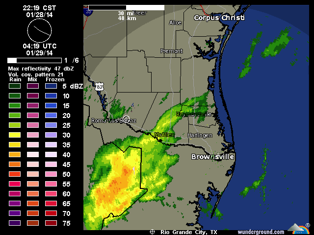
Special 06z Balloon being released..
AREA FORECAST DISCUSSION...UPDATED
NATIONAL WEATHER SERVICE BROWNSVILLE TX
1020 PM CST TUE JAN 28 2014
.DISCUSSION...RADAR LIGHTING UP WITH PRECIP TO THE WEST AND
SOUTHWEST AS INFLUENCE FROM 850MB FRONTOGENESIS AND LIFT FROM THE
UPPER LOW TO THE SOUTHWEST COME TOGETHER. TEMPERATURES ACROSS THE
CWA ARE ABOVE FREEZING WITH DEWPOINTS IN THE TEENS. WE WILL LOSE
SOME PRECIP TO DRY NEAR SURFACE AIR. PRECIP AMOUNTS ARE TRENDING A
LITTLE HIGHER WITH MODEL SOUNDINGS AND OBSERVED SOUNDINGS
SUGGESTING SLEET.
A SPECIAL 06Z BALLOON WILL BE RELEASED WITHIN THE HOUR THAT WILL
PROVIDE CRITICAL TEMPERATURE PROFILE DATA. IF THAT INFORMATION
SHOWS A COLDER THAN EXPECTED PROFILE...WINTER STORM WARNINGS FOR
SLEET /MAY/ BE REQUIRED FOR PARTS OF THE AREA...MAINLY IN THE
MIDDLE AND UPPER VALLEY...BASED ON PRECIP TRENDS. /68-JGG/
Latest Saved Radar Loop..

0 likes
The following post is NOT an official forecast and should not be used as such. It is just the opinion of the poster and may or may not be backed by sound meteorological data. It is NOT endorsed by any professional institution including storm2k.org For Official Information please refer to the NHC and NWS products.

Who is online
Users browsing this forum: No registered users and 28 guests