
I see nothing wrong with it, it still has two powerful systems with lots of qpf. As I said the cold will come and these type of ejections only trend south. i just hope it ends as snow when the trends are done and not ice because with that much liquid it will not be pretty.
With how the 5h pattern looks and how the teleconnections have evolved with these dual systems reminds me of feb 2011.
Texas Winter 2013-2014
Moderator: S2k Moderators
Forum rules
 The posts in this forum are NOT official forecast and should not be used as such. They are just the opinion of the poster and may or may not be backed by sound meteorological data. They are NOT endorsed by any professional institution or STORM2K.

The posts in this forum are NOT official forecast and should not be used as such. They are just the opinion of the poster and may or may not be backed by sound meteorological data. They are NOT endorsed by any professional institution or STORM2K.
Last edited by Ntxw on Wed Jan 29, 2014 3:35 pm, edited 1 time in total.
0 likes
The above post and any post by Ntxw is NOT an official forecast and should not be used as such. It is just the opinion of the poster and may or may not be backed by sound meteorological data. It is NOT endorsed by any professional institution including Storm2k. For official information, please refer to NWS products.
Help support Storm2K!
-
CYCLONE MIKE
- Category 5

- Posts: 2183
- Joined: Tue Aug 31, 2004 6:04 pm
- Location: Gonzales, LA
Re: Texas Winter 2013-2014
Well after a disappointing storm yesterday I'm stuck at home trying to find some snow for us  According to the 12z gfs looks like we're in for a spring-like warm up til this time next week. Then a drastic change with a massive cool down once again. Unfortunately doesn't look like any moisture for now but we all know how that can change.


Last edited by CYCLONE MIKE on Wed Jan 29, 2014 3:35 pm, edited 1 time in total.
0 likes
-
wxman57

- Moderator-Pro Met

- Posts: 23174
- Age: 68
- Joined: Sat Jun 21, 2003 8:06 pm
- Location: Houston, TX (southwest)
Re: Texas Winter 2013-2014
12Z Euro keeps that nasty cold snow north of Texas. It's centered up in Oklahoma and eastward.

0 likes
-
TheProfessor

- Professional-Met

- Posts: 3506
- Age: 29
- Joined: Tue Dec 03, 2013 10:56 am
- Location: Wichita, Kansas
Re:
Ntxw wrote:I see nothing wrong with it, it still has two powerful systems with lots of qpf. As I said the cold will come and these type of ejections only trend snow. i just hope it ends as snow when the trends are done and not ice because with that much liquid it will not be pretty.
With how the 5h pattern looks and how the teleconnections have evolved with these dual systems reminds me of feb 2011.
It does, that storm also had two systems, for me the first one dropped about 2 inches of sleet and 2 inches of snow. The second part dumped about 6 inches of snow on top of that.
I too also hope that we are able to avoid Icemageddon 3.
0 likes
An alumnus of The Ohio State University.
Your local National Weather Service office is your best source for weather information.
Your local National Weather Service office is your best source for weather information.
-
TheProfessor
- Professional-Met
- Posts: 3506
- Age: 29
- Joined: Tue Dec 03, 2013 10:56 am
- Location: Wichita, Kansas
Re: Texas Winter 2013-2014
wxman57 wrote:12Z Euro keeps that nasty cold snow north of Texas. It's centered up in Oklahoma and eastward.
http://home.comcast.net/~cgh57/eurosnow2.gif
Why does this map look so different than the other one posted on the page before?
0 likes
An alumnus of The Ohio State University.
Your local National Weather Service office is your best source for weather information.
Your local National Weather Service office is your best source for weather information.
-
wxman57
- Moderator-Pro Met
- Posts: 23174
- Age: 68
- Joined: Sat Jun 21, 2003 8:06 pm
- Location: Houston, TX (southwest)
Re: Texas Winter 2013-2014
TheProfessor wrote:wxman57 wrote:12Z Euro keeps that nasty cold snow north of Texas. It's centered up in Oklahoma and eastward.
http://home.comcast.net/~cgh57/eurosnow2.gif
Why does this map look so different than the other one posted on the page before?
The difference is due to the 12Z Euro taking the upper low about 150 miles farther north across TX. It's also weaker and a little faster-moving vs. the 00Z run, which is closer to the 12z GFS. The 12Z GFS slowed down the short wave it had zipping across TX on Tuesday and has a little deeper trof across TX Tue PM/Wed.
Basically, the Euro is trending faster, weaker and farther north with the upper low and the GFS is trending in the opposite direction but closer to the 12Z Euro.
0 likes
-
Tireman4

- S2K Supporter

- Posts: 5903
- Age: 60
- Joined: Fri Jun 30, 2006 1:08 pm
- Location: Humble, Texas
- Contact:
Re: Texas Winter 2013-2014
wxman57 wrote:12Z Euro keeps that nasty cold snow north of Texas. It's centered up in Oklahoma and eastward.
http://home.comcast.net/~cgh57/eurosnow2.gif
Could you turn that upside down sir? Thanks....and you know...models 9 days out......
0 likes
-
TheProfessor
- Professional-Met
- Posts: 3506
- Age: 29
- Joined: Tue Dec 03, 2013 10:56 am
- Location: Wichita, Kansas
Re: Texas Winter 2013-2014
wxman57 wrote:TheProfessor wrote:wxman57 wrote:12Z Euro keeps that nasty cold snow north of Texas. It's centered up in Oklahoma and eastward.
http://home.comcast.net/~cgh57/eurosnow2.gif
Why does this map look so different than the other one posted on the page before?
The difference is due to the 12Z Euro taking the upper low about 150 miles farther north across TX. It's also weaker and a little faster-moving vs. the 00Z run, which is closer to the 12z GFS. The 12Z GFS slowed down the short wave it had zipping across TX on Tuesday and has a little deeper trof across TX Tue PM/Wed.
Basically, the Euro is trending faster, weaker and farther north with the upper low and the GFS is trending in the opposite direction but closer to the 12Z Euro.
Sorry I should have been more specific. Why is it different than the other 12z Euro map posted on the page before?
0 likes
An alumnus of The Ohio State University.
Your local National Weather Service office is your best source for weather information.
Your local National Weather Service office is your best source for weather information.
-
CYCLONE MIKE
- Category 5
- Posts: 2183
- Joined: Tue Aug 31, 2004 6:04 pm
- Location: Gonzales, LA
Re: Texas Winter 2013-2014
somethingfunny wrote:The 12z Euro is a little more reasonable.
It still depicts snowfall for much of Texas, but these events are still a long way off and I'm really not expecting anything to happen or to not happen at this point.
http://models.weatherbell.com/ecmwf/201 ... _tx_41.png
Wxman, why does this map and the one you posted look so different even though they are both 12z euro? Also does it send the cold more east than south or look like the gfs?
0 likes
-
wxman57
- Moderator-Pro Met
- Posts: 23174
- Age: 68
- Joined: Sat Jun 21, 2003 8:06 pm
- Location: Houston, TX (southwest)
Re: Texas Winter 2013-2014
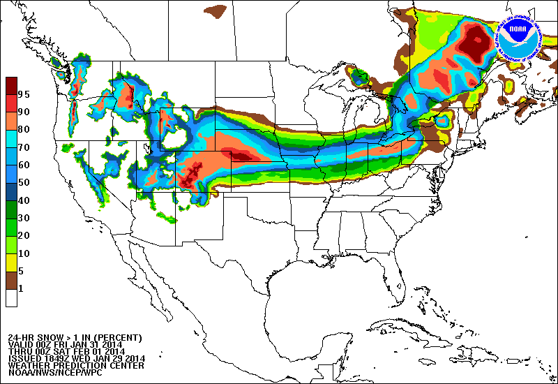
Ah, I see now. The map posted earlier (not by me) is a CUMULATIVE snowfall from 0hr to 240hr. The map I posted is just for a 24hr period next Tue-Wed. There is a second event that the Euro sees Thu/Fri of next week that was not included on my first map:

0 likes
-
Portastorm

- Storm2k Moderator

- Posts: 9955
- Age: 63
- Joined: Fri Jul 11, 2003 9:16 am
- Location: Round Rock, TX
- Contact:
Re: Texas Winter 2013-2014
As the NWS/NOAA national weather desk spoke of earlier today in its 3-7 day forecast discussion, Texas next week is going to be the location for a baroclinic zone. That essentially is a long line across the state whereas north of that line you'll have much colder temperatures than you will south of it. Baroclinic zones often foster significant cyclogenesis (i.e. formation of surface lows) which can end up being quite active storm systems. These systems can feature snowstorm/blizzard-like conditions on the northern side of these zones and stormy/spring-like storms to the south of these zones. Think of the baroclinic zones (or lines) themselves as the race track on which the surface lows will travel.
One thing appears more likely than not and that is next week will not be a boring one for Texas weather.
One thing appears more likely than not and that is next week will not be a boring one for Texas weather.
0 likes
Any forecasts under my name are to be taken with a grain of salt. Get your best forecasts from the National Weather Service and National Hurricane Center.
-
CYCLONE MIKE
- Category 5
- Posts: 2183
- Joined: Tue Aug 31, 2004 6:04 pm
- Location: Gonzales, LA
Re: Texas Winter 2013-2014
Thanks for clarifying that. Do the temps look in line with what the 12z gfs are showing? Gfs looks pretty cold, again.
0 likes
-
Lagreeneyes03
- Category 2

- Posts: 610
- Joined: Mon Dec 09, 2013 10:53 am
- Location: Luxurious Lake Grapevine
-
aggiecutter
- Category 5
- Posts: 1755
- Joined: Thu Oct 14, 2004 9:22 pm
- Location: Texarkana
Re: Texas Winter 2013-2014
Portastorm wrote:As the NWS/NOAA national weather desk spoke of earlier today in its 3-7 day forecast discussion, Texas next week is going to be the location for a baroclinic zone. That essentially is a long line across the state whereas north of that line you'll have much colder temperatures than you will south of it. Baroclinic zones often foster significant cyclogenesis (i.e. formation of surface lows) which can end up being quite active storm systems. These systems can feature snowstorm/blizzard-like conditions on the northern side of these zones and stormy/spring-like storms to the south of these zones. Think of the baroclinic zones (or lines) themselves as the race track on which the surface lows will travel.
One thing appears more likely than not and that is next week will not be a boring one for Texas weather.
Looking at the model trends, the first storm will be more of a heavy rain and severe weather event for north Texas east of I-35. The second storm later in the week is more plausible, and I could see that happening.
It is just the opinion of the poster and may or may not be backed by sound meteorological data. It is NOT endorsed by any professional institution including storm2k.org. For official information, please refer to NWS products.
0 likes
-
wxman57
- Moderator-Pro Met
- Posts: 23174
- Age: 68
- Joined: Sat Jun 21, 2003 8:06 pm
- Location: Houston, TX (southwest)
Re: Texas Winter 2013-2014
CYCLONE MIKE wrote:Thanks for clarifying that. Do the temps look in line with what the 12z gfs are showing? Gfs looks pretty cold, again.
12Z Euro deterministic has coldest of 26F at DFW airport next week.
0 likes
-
orangeblood
- S2K Supporter
- Posts: 3895
- Joined: Tue Dec 15, 2009 6:14 pm
- Location: Fort Worth, TX
Re: Texas Winter 2013-2014
aggiecutter wrote:Portastorm wrote:As the NWS/NOAA national weather desk spoke of earlier today in its 3-7 day forecast discussion, Texas next week is going to be the location for a baroclinic zone. That essentially is a long line across the state whereas north of that line you'll have much colder temperatures than you will south of it. Baroclinic zones often foster significant cyclogenesis (i.e. formation of surface lows) which can end up being quite active storm systems. These systems can feature snowstorm/blizzard-like conditions on the northern side of these zones and stormy/spring-like storms to the south of these zones. Think of the baroclinic zones (or lines) themselves as the race track on which the surface lows will travel.
One thing appears more likely than not and that is next week will not be a boring one for Texas weather.
Looking at the model trends, the first storm will be more of a heavy rain and severe weather event for north Texas east of I-35. The second storm later in the week is more plausible, and I could see that happening.
It is just the opinion of the poster and may or may not be backed by sound meteorological data. It is NOT endorsed by any professional institution including storm2k.org. For official information, please refer to NWS products.
Agreed, the snowcover across the central plains should be fairly significant after the 1st system exits. And with the big HP coming down from Canada on the backside of the low pressure, Fresh cold air over fresh snowcover is a great recipe for the 2nd system to create more winter weather further south into Texas. Not to say the 1st system doesn't have potential for those south of the Red River but at this time it looks more like an Oklahoma winter weather maker.
The following post is NOT an official forecast and should not be used as such. It is just the opinion of the poster and may or may not be backed by sound meteorological data. It is NOT endorsed by any professional institution including storm2k.org. For official information, please refer to NWS products
0 likes

Re: Texas Winter 2013-2014
Posting this picture from 2010. Hopefully it brings us another 12 inches of snow... 

0 likes
-
srainhoutx

- S2K Supporter
- Posts: 6919
- Age: 68
- Joined: Sun Jan 14, 2007 11:34 am
- Location: Haywood County, NC
- Contact:
Re: Texas Winter 2013-2014
Another thing to monitor is the progression of Winter Storms spreading across the Central Plains. The dry NW flow aloft that has been present for the past 35-40 days will change beginning later this week with the first in a series of storms that will lay down snow where there has been little to none. That should assist in less air mass modification as that snow pack increase over time.
0 likes
Carla/Alicia/Jerry(In The Eye)/Michelle/Charley/Ivan/Dennis/Katrina/Rita/Wilma/Ike/Harvey
Member: National Weather Association
Wx Infinity Forums
http://wxinfinity.com/index.php
Facebook.com/WeatherInfinity
Twitter @WeatherInfinity
Member: National Weather Association
Wx Infinity Forums
http://wxinfinity.com/index.php
Facebook.com/WeatherInfinity
Twitter @WeatherInfinity
-
WeatherGuesser
- Category 5
- Posts: 2672
- Joined: Tue Jun 29, 2010 6:46 am
Re: Texas Winter 2013-2014
srainhoutx wrote:Another thing to monitor is the progression of Winter Storms spreading across the Central Plains. The dry NW flow aloft that has been present for the past 35-40 days will change beginning later this week with the first in a series of storms that will lay down snow where there has been little to none. That should assist in less air mass modification as that snow pack increase over time.
Now THAT map I'll take. That puts it all north of me, unlike one I saw here earlier.
0 likes
-
gboudx

- S2K Supporter
- Posts: 4090
- Joined: Thu Sep 04, 2003 1:39 pm
- Location: Rockwall, Tx but from Harvey, La
Re:
Lagreeneyes03 wrote:McCauley's "stat method" shows "no snow...for now
From my very short time of reading his FB page, I think the timeframe is too far out right now for his SM to pick up on it. If by Saturday or Sunday it's not seeing it, then don't even give the Lucy the satisfaction.
0 likes
Who is online
Users browsing this forum: No registered users and 28 guests