ATL: BERTHA - Post-Tropical - Discussion

Moderator: S2k Moderators

Message
Author
User avatar
NDG
S2K Supporter
S2K Supporter
Posts: 15446
Joined: Sun Jul 09, 2006 10:14 pm
Location: Orlando, FL

Re:

#621 Postby NDG » Thu Jul 31, 2014 4:12 pm

RL3AO wrote:93L is skimming south of an area of very dry air with fairly high winds. IMO much of that 45kt wind the hunters are finding is not the tropical low, but apart of the SAL push.

http://i794.photobucket.com/albums/yy22 ... 30da09.png


There is some nice pressure gradient to the north of 93L which has a pressure of around 1007-1008mb, pressures to the north of it are much higher around 10014-1015 mb in a relatively short distance.
0 likes   

ninel conde

Re: ATL: INVEST 93L - Discussion

#622 Postby ninel conde » Thu Jul 31, 2014 4:19 pm

Blown Away wrote:Image
Some low clouds wrapping in... Nice little circulation...


looks par for the course the last few seasons. i expect it might find some moisture as it trucks on NE in a few days.
0 likes   

User avatar
NDG
S2K Supporter
S2K Supporter
Posts: 15446
Joined: Sun Jul 09, 2006 10:14 pm
Location: Orlando, FL

#623 Postby NDG » Thu Jul 31, 2014 4:19 pm

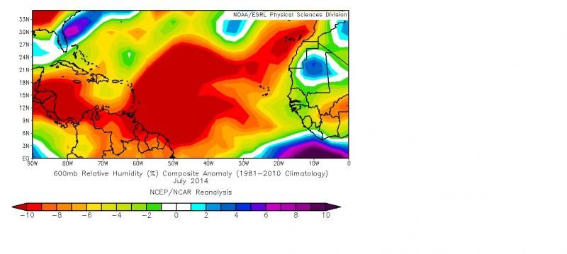
From Today's CSU forecast update, this is how bone dry July was in the Atlantic at H60, they think is the driest ever. No wonder TD2 and 93L have struggled so much.
Very weird when the sub Saharan area in Africa has had wetter than normal wx.

Image
0 likes   

ninel conde

Re:

#624 Postby ninel conde » Thu Jul 31, 2014 4:20 pm

NDG wrote:From Today's CSU forecast update, this is how bone dry July was in the Atlantic at H60, they think is the driest ever. No wonder TD2 and 93L have struggled so much.
Very weird when the sub Saharan area in Africa has had wetter than normal wx.

Image


the desert conditions extend well into the atlantic north of the tropics as well.
0 likes   

Sanibel
Category 5
Category 5
Posts: 10375
Joined: Mon Aug 30, 2004 11:06 pm
Location: Offshore SW Florida

Re: ATL: INVEST 93L - Discussion

#625 Postby Sanibel » Thu Jul 31, 2014 4:21 pm

The dry air is winning. It could re-fire but will it survive the Caribbean?
0 likes   

Frank2
Category 5
Category 5
Posts: 4061
Joined: Mon Jul 25, 2005 12:47 pm

Re: ATL: INVEST 93L - Discussion

#626 Postby Frank2 » Thu Jul 31, 2014 4:23 pm

I always find it ironic that the air can be so dry over so much water...

P.S. I did see the photo of 93L on the previous page - not very impressive at all...
Last edited by Frank2 on Thu Jul 31, 2014 4:24 pm, edited 1 time in total.
0 likes   

User avatar
northjaxpro
S2K Supporter
S2K Supporter
Posts: 8900
Joined: Mon Sep 27, 2010 11:21 am
Location: Jacksonville, FL

#627 Postby northjaxpro » Thu Jul 31, 2014 4:23 pm

For a organized tropical cyclone to be designated, convection must be around or very close within the center of circulation, which we simply do not have at this time. I think 93L is on its last legs right now. The system is really up against it with the dry air and later on shear down the road. Unless we see convection fire later tonight around the LLC, 93L will be history and a Bones sighting will be on this thread very soon. We will see what happens tonight.
Last edited by northjaxpro on Thu Jul 31, 2014 4:30 pm, edited 3 times in total.
0 likes   
NEVER, EVER SAY NEVER in the tropics and weather in general, and most importantly, with life itself!!

________________________________________________________________________________________

Fay 2008 Beryl 2012 Debby 2012 Colin 2016 Hermine 2016 Julia 2016 Matthew 2016 Irma 2017 Dorian 2019

User avatar
NDG
S2K Supporter
S2K Supporter
Posts: 15446
Joined: Sun Jul 09, 2006 10:14 pm
Location: Orlando, FL

Re: ATL: INVEST 93L - Discussion

#628 Postby NDG » Thu Jul 31, 2014 4:24 pm

Sanibel wrote:The dry air is winning. It could re-fire but will it survive the Caribbean?


I think the only area it can do anything is north of the Greater Antilles, east of US Atlantic coast, where best conditions in the Atlantic have been more often than not.
0 likes   

User avatar
gatorcane
S2K Supporter
S2K Supporter
Posts: 23691
Age: 47
Joined: Sun Mar 13, 2005 3:54 pm
Location: Boca Raton, FL

Re: ATL: INVEST 93L - Discussion

#629 Postby gatorcane » Thu Jul 31, 2014 4:27 pm

NDG wrote:
Sanibel wrote:The dry air is winning. It could re-fire but will it survive the Caribbean?


I think the only area it can do anything is north of the Greater Antilles, east of US Atlantic coast, where best conditions in the Atlantic have been more often than not.


Actually looking at the GFS, conditions across the entire Caribbean become quite favorable in about 72 hours (at least from a shear perspective) with that screaming shear dropping off, just in time for August. Actually I see a large anticyclone centered over the South-Central Caribbean in about 5-6 days from now. Fortunately this system is not heading west across the Caribbean.

The posts in this forum are NOT official forecast and should not be used as such. They are just the opinion of the poster and may or may not be backed by sound meteorological data. They are NOT endorsed by any professional institution or storm2k.org. For official information, please refer to the NHC and NWS products.
Last edited by gatorcane on Thu Jul 31, 2014 4:30 pm, edited 2 times in total.
0 likes   

User avatar
NDG
S2K Supporter
S2K Supporter
Posts: 15446
Joined: Sun Jul 09, 2006 10:14 pm
Location: Orlando, FL

Re: ATL: INVEST 93L - Discussion

#630 Postby NDG » Thu Jul 31, 2014 4:28 pm

Frank2 wrote:I always find it ironic that the air can be so dry over so much water...

P.S. I did see the photo of 93L on the previous page - not very impressive at all...


There is always fairly humid air at the surface but without widespread instability there is nothing to make that moist air rise to the mid levels of the atmosphere after convection forms. But yes, I know what you mean that one would think that the atmosphere would automatically be moist over such a large ocean.
0 likes   

User avatar
NDG
S2K Supporter
S2K Supporter
Posts: 15446
Joined: Sun Jul 09, 2006 10:14 pm
Location: Orlando, FL

Re: ATL: INVEST 93L - Discussion

#631 Postby NDG » Thu Jul 31, 2014 4:30 pm

gatorcane wrote:
NDG wrote:
Sanibel wrote:The dry air is winning. It could re-fire but will it survive the Caribbean?


I think the only area it can do anything is north of the Greater Antilles, east of US Atlantic coast, where best conditions in the Atlantic have been more often than not.


Actually looking at the GFS, conditions across the entire Caribbean become quite favorable in about 72 hours with that screaming shear dropping off, just in time for August. Fortunately this system is not heading west across the Caribbean.

The posts in this forum are NOT official forecast and should not be used as such. They are just the opinion of the poster and may or may not be backed by sound meteorological data. They are NOT endorsed by any professional institution or storm2k.org. For official information, please refer to the NHC and NWS products.


Yes, I have been seeing the GFS show that but I don't believe it until I see it, but there is always the threat for low level shear which could be even more destructive.
0 likes   

User avatar
MGC
S2K Supporter
S2K Supporter
Posts: 5899
Joined: Sun Mar 23, 2003 9:05 pm
Location: Pass Christian MS, or what is left.

Re: ATL: INVEST 93L - Discussion

#632 Postby MGC » Thu Jul 31, 2014 4:30 pm

Surprised by the low pressure and high winds. I bet some will argue that 93L was likely a TS very early this morning when the convection was more robust. So, what will the NHC do? Here we have a naked swirl with TS winds headed towards populated islands? Upgrade, or let the island weather bureaus handle it?....MGC
0 likes   

User avatar
SouthDadeFish
Professional-Met
Professional-Met
Posts: 2835
Joined: Thu Sep 23, 2010 2:54 pm
Location: Miami, FL
Contact:

#633 Postby SouthDadeFish » Thu Jul 31, 2014 4:32 pm

Keep in mind there are other ways to get dry air in the mid-levels of the atmosphere other than SAL. Subsidence is another primary way. Anyway, I think the shear vorticity associated with the strong low-level trades is what has kept the circulation so vigorous despite the lack of convection. The swirl will begin to lose this shear vorticity as it gains latitude.
0 likes   

User avatar
northjaxpro
S2K Supporter
S2K Supporter
Posts: 8900
Joined: Mon Sep 27, 2010 11:21 am
Location: Jacksonville, FL

Re: ATL: INVEST 93L - Discussion

#634 Postby northjaxpro » Thu Jul 31, 2014 4:36 pm

MGC wrote:Surprised by the low pressure and high winds. I bet some will argue that 93L was likely a TS very early this morning when the convection was more robust. So, what will the NHC do? Here we have a naked swirl with TS winds headed towards populated islands? Upgrade, or let the island weather bureaus handle it?....MGC


No upgrade unless convection bursts near the LLC. I would be very surprised if NHC pulled the trigger right now.
0 likes   
NEVER, EVER SAY NEVER in the tropics and weather in general, and most importantly, with life itself!!

________________________________________________________________________________________

Fay 2008 Beryl 2012 Debby 2012 Colin 2016 Hermine 2016 Julia 2016 Matthew 2016 Irma 2017 Dorian 2019
TJRE
Tropical Storm
Tropical Storm
Posts: 188
Joined: Sun Jun 02, 2013 9:04 am
Location: New Jersey

Re: ATL: INVEST 93L - Discussion

#635 Postby TJRE » Thu Jul 31, 2014 4:42 pm

CIMSS check-in

Image

to B or not to B..... that is the question

http://tropic.ssec.wisc.edu/
0 likes   

Frank2
Category 5
Category 5
Posts: 4061
Joined: Mon Jul 25, 2005 12:47 pm

#636 Postby Frank2 » Thu Jul 31, 2014 4:43 pm

In the NHC days forcaster Gil Clark would call them "screaming easterlies" of 40-50 kts that came behind a wave axis...

P.S. Thanks for that explaanation, NDG - makes sense...
0 likes   

User avatar
'CaneFreak
Category 5
Category 5
Posts: 1486
Joined: Mon Jun 05, 2006 10:50 am
Location: New Bern, NC

Re:

#637 Postby 'CaneFreak » Thu Jul 31, 2014 4:50 pm

Ding ding ding. We have a winner. Best post I have read all day. Shear vorticity is the only thing keeping this thing alive. 41 degree dewpoint depressions were found at 500 mb this afternoon just east of Guadeloupe. Horrid out there.

SouthDadeFish wrote:Keep in mind there are other ways to get dry air in the mid-levels of the atmosphere other than SAL. Subsidence is another primary way. Anyway, I think the shear vorticity associated with the strong low-level trades is what has kept the circulation so vigorous despite the lack of convection. The swirl will begin to lose this shear vorticity as it gains latitude.
0 likes   

User avatar
NDG
S2K Supporter
S2K Supporter
Posts: 15446
Joined: Sun Jul 09, 2006 10:14 pm
Location: Orlando, FL

Re: ATL: INVEST 93L - Discussion

#638 Postby NDG » Thu Jul 31, 2014 5:47 pm

Perhaps it wouldn't hurt to have special flight missions in the MDR for the remainder of the hurricane season sampling the atmosphere to keep hurricane models from over developing tropical waves that way the NHC will have a better idea of what percentage to give for development. IMO.
0 likes   

RL3AO
Moderator-Pro Met
Moderator-Pro Met
Posts: 16308
Joined: Thu Jun 14, 2007 10:03 pm
Location: NC

Re: ATL: INVEST 93L - Discussion

#639 Postby RL3AO » Thu Jul 31, 2014 6:03 pm

NDG wrote:Perhaps it wouldn't hurt to have special flight missions in the MDR for the remainder of the hurricane season sampling the atmosphere to keep hurricane models from over developing tropical waves that way the NHC will have a better idea of what percentage to give for development. IMO.


I don't think its a data problem. Models are clearly showing how dry it is.
0 likes   

User avatar
Evil Jeremy
S2K Supporter
S2K Supporter
Posts: 5463
Age: 32
Joined: Mon Apr 10, 2006 2:10 pm
Location: Los Angeles, CA

Re: ATL: INVEST 93L - Discussion

#640 Postby Evil Jeremy » Thu Jul 31, 2014 6:04 pm

Not to give anyone a headache (well, a bigger one), but convection is popping again, on the right side of the LLC. It was around this time last night that convection started refiring, and held into the night.
0 likes   
Frances 04 / Jeanne 04 / Katrina 05 / Wilma 05 / Fay 08 / Debby 12 / Andrea 13 / Colin 16 / Hermine 16 / Matthew 16 / Irma 17


Return to “2014”

Who is online

Users browsing this forum: No registered users and 2 guests